Meeting of the Port Phillip City Council
6 March 2024
|
Welcome Welcome to this Meeting of the Port Phillip City Council. Council Meetings are an important way to ensure that your democratically elected representatives are working for you in a fair and transparent way. They also allow the public to be involved in the decision-making process of Council. About this meeting There are a few things to know about tonight’s meeting. The first page of tonight’s Agenda itemises all the different parts to the meeting. Some of the items are administrative and are required by law. In the agenda you will also find a list of all the items to be discussed this evening. Each report is written by a Council officer outlining the purpose of the report, all relevant information and a recommendation. Council will consider the report and either accept the recommendation or make amendments to it. All decisions of Council are adopted if they receive a majority vote from the Councillors present at the meeting. |
Public Question Time and Submissions Provision is made at the beginning of the meeting for general question time from members of the public. All contributions from the public will be heard at the start of the meeting during the agenda item 'Public Questions and Submissions.' Members of the public have the option to either participate in person or join the meeting virtually via Teams to ask their questions live during the meeting. If you would like to address the Council and /or ask a question on any of the items being discussed, please submit a ‘Request to Speak form’ by 4pm on the day of the meeting via Council’s website: Request to speak at a Council meeting - City of Port Phillip |
|
|
|
To Councillors
Notice is hereby given that a Meeting of the Port Phillip City Council will be held in St Kilda Town Hall and Virtually via Teams on Wednesday, 6 March 2024 at 6:30pm. At their discretion, Councillors may suspend the meeting for short breaks as required.
AGENDA
1 APOLOGIES
2 MINUTES OF PREVIOUS MEETINGS
Minutes of the Meeting of the Port Phillip City Council 21 February 2024.
3 Declarations of Conflicts of Interest
4 Public Question Time and Submissions
5 Councillor Question Time
6 Sealing Schedule
Nil
7 Petitions and Joint Letters
7.1 Petition: Protect our weekly wellness gathering: FeelGoodFlows............................................................. 7
7.2 Petition: Request for use of Elwood Primary School Reserve as an Off-Leash Dog Park........................... 15
7.3 Petiton: City of Port Phillip Rental Crisis ................... 16
8 Presentation of CEO Report
8.1 Presentation of December CEO Report - Issue 103.. 21
9 Inclusive Port Phillip
9.1 Older Persons Advisory Committee Annual Report 2023 - For Endorsement............................................. 25
10 Liveable Port Phillip
10.1 Cowderoy Street Right Turn Restriction Trial............. 35
10.2 Barak Beacon Public Housing Estate......................... 47
10.3 Draft Housing Strategy and Phase 3 Community consultation............................................................... 107
10.4 City of Port Phillip Spatial Economic and Employment Framework (SEEF): Adoption................................... 119
11 Sustainable Port Phillip
Nil
12 Vibrant Port Phillip
Nil
13 Well Governed Port Phillip
13.1 City of Port Phillip Advocacy Strategy...................... 133
13.2 Municipal Association of Victoria State Council - May 2024 - Submissions.................................................. 137
13.3 Proposed Discontinuance of Road Adjoining 3-5, 7, 9, and 15 Fitzroy Street, St Kilda.................................. 143
13.4 Audit and Risk Committee - Biannual Report as at 31 December 2023 AND Annual Review of the Committee Charter...................................................................... 151
13.5 Status of Council Decisions and Questions Taken on Notice recorded by Council: 1 October - 31 December 2023.......................................................................... 155
14 Notices of Motion
Nil
15 Reports by Councillor Delegates
16 URGENT BUSINESS
17 Confidential Matters................................................ 163
The information contained in the following Council reports is considered to be Confidential Information in accordance with Section 3 of the Local Government Act 2020.
17.1 Discussion papers from the Department of Transport and Planning - Modernising Parking Requirements & Improving Residential Development Standards for Small Lots
3(1)(c) land use planning information, being information that if prematurely released is likely to encourage speculation in land values.
Reason:
Proposed changes to the planning scheme regarding
parking and
small lot requirements may impact property values or development decisions
17.2 Provision of Recycling Processing Services
3(1)(a). Council business information, being information that would prejudice the Council's position in commercial negotiations if prematurely released
3(1)(g(i)) private commercial information, being information provided by a business, commercial or financial undertaking that relates to trade secrets
3(1)(g(ii)) private commercial information, being information provided by a business, commercial or financial undertaking that if released, would unreasonably expose the business, commercial or financial undertaking to disadvantage.
Reason:
The report contains Commercial sensative material which will allow non successful applicants the oppurtunity to reverse engineer the successful pricing.
Meeting of the Port Phillip City Council
6 March 2024
3. Declarations of Conflicts of Interest
4. Public Question Time and Submissions
5. Councillor Question Time
6. Sealing Schedule
Nil
7. Petitions and Joint Letters
7.1 Petition: Protect our weekly wellness gathering: FeelGoodFlows............................................................. 7
7.2 Petition: Request for use of Elwood Primary School Reserve as an Off-Leash Dog Park........................... 15
7.3 Petiton: City of Port Phillip Rental Crisis ................... 16
Item 7.1 Petition: Protect our weekly Wellness Gathering: FeelGoodFlows
A Petition containing 7647 signatures, was received via change.org.
The Petition states the following:-
My name is Eliza, I am the founder of Feel Good Flows, an offering that has been here for you consistently for four years as a response to the mental health crisis that we endured during isolation in lock down.
I am thrilled to see the growth of our community. Since day one I enquired and paid the council for permission to use this land to offer the community wellness by donation for those who can, free for those who can’t. I need your help to protect it.
We have now gathered on St Kilda Beach for four years peacefully to pause, be still, reset, meditate, breathe, & move under the open skies, by the sea. We then stay to connect and chat over chais and fruits… all sourced locally and prepared for the community to enjoy complimentary.
Now the council wants to restrict Feel Good Flows to just 15 people per gathering on the public beach under the current permit fees I have been paying for four years OR have me pay an event fee of $400+ every single time we gather.
We have no infrastructure, no signage, no microphones, no litter, nothing… just a group of people peacefully gathering in nature.
We are an all-welcoming weekly wellness gathering offered by donation, and you don’t have funds to pay a donation, don't worry just come.
Restricting numbers, means telling people that they are not welcome to join, that they “can’t sit with us” that they need to leave this public beach and do what… move 1.5m away from the rest of the group? Go home?
Imagining the impact of this on an individual who has maybe taken a bit of courage and effort to show up alone to a community gathering only to be turned away… is honestly heart breaking.
So now paying the council $400+ per event is the only option, but that puts us at a significant loss and our “honest donation” foundation model would need to change… which it never will. This is an exorbitant amount for a gathering of just one hour on public beaches - especially where we leave the area better than how we found it by cleaning regularly.
Furthermore the council has suggested the frequency of the events may be impacted and we are not guaranteed permission at all.
These suggestions would mean the cancellation of Feel Good Flows St Kilda Sundays… as well as our recently launched Elwood Sunrises.
We are gathered on public land, we have no loud branding, flags, or even microphones, we welcome all walking by pedestrians to join us, there is no membership, no branded hoodies, no merch, nothing to buy, there are no questions asked, just come as you are and connect with the community.
I’m usually good at doing it all on my own… but we are a community and I need your help to communicate this message to the council and to come to a fair and sustainable solution for Feel Good Flows moving forward.
I am meeting with the mayor next week who important to note has said she loves what we are doing and is hoping she can help.
Thanking you in advance for your support of our weekly wellness ritual.
OFFICER COMMENT
Background
In the last five years, and particularly throughout the impacts of COVID, Council saw significant increase in requests for personal trainers, bootcamps, yoga, ice baths and general mental and physical health providers seeking to conduct their operations in public open space. This trend continues and we have a number of wellness providers operating along the foreshore and in public parks.
The foreshore is the most requested location.
To manage these requests, Council endorsed the Fitness Training Policy 2021 . Under the Local Law this policy permits all ongoing outdoor group activities by commercial operators, including yoga and wellness classes. This Policy is located on Council’s website and its conditions are reflected in the permit issued to the operator.
The key objectives of this policy are:
· To preserve the quality and longevity of public open space and council assets within these spaces
· To ensure fitness training activities do not unreasonably impact community access to public open space
· To ensure all who recreate on Council owned and managed land within the City of Port Phillip are provided with a safe environment to do so
· To provide equity in the management of outdoor fitness trainers, considering other fitness and commercial recreation providers and events who operate in the municipality
· To provide health and wellbeing opportunities to support physical and mental health for all members of the community through outdoor fitness training
The Policy:
· identifies permissible activities, which includes personal training boxing, aerobics, yoga, Pilates, bootcamps, running or related activities.
· identifies suitable sites for activities (occupying a space of no greater than 20 x 20m) and restricted sites (including pathways).
· Restricts participant numbers to 15 people per session, with lower numbers approved at some locations.
These licences are restricted to 15 people to:
· Protect and preserve our natural environment.
· Provide equitable access to our limited public space for diverse activities.
· Ensure activities are safe and well-managed.
· Balance the needs of all open space users, including residents and visitors.
The following is considered when making decisions on suitable locations: local amenity; size of open space, level and type of other usage; community events; capital works projects; suitability of activity offered; existing infrastructure; and informal community use.
Licence and Fees
Under our Local Law, both a permit and licence is required to operate this type of activity in the municipality. Both include all the required conditions in line with the Policy.
While both the Licence and Permit are administered by Council, the licence is a Department of Environment, Energy and Climate Action (DEECA) requirement.
The DEECA licence is required by all Personal Training providers. This licence is also known as a Tour Operator licence and was introduced by DEECA to set safety standards, mitigate risks and protect natural and cultural areas. DEECA’s website outlines the following – A tour operator licence is required for “Commercial outdoor recreational activities are inclusive of fitness, stretch, strength and wellness activities such as yoga, personal training, boot camps, and organised swimming or running”.
The 2023/24 annual once off fee for this licence is $331. This fee includes up to two approved locations and at these locations providers can run multiple sessions across the week, enabling them to cater to more participants. The locations and the class numbers are set within the licence/permit.
We currently have eight (8) businesses operating under these permits. Including four (4) wellness classes. Combined this is around 15 classes (hours) a week on the foreshore.
Council receives a number of requests to operate on our beaches, in the last month we have permitted new wellness classes in Elwood and St Kilda and have had to speak with another yoga business who have been operating in St Kilda without a permit.
Other Council Permits for Use of Public Space
Other Council permits provide businesses and community groups with the ability to use public space. They are:
Outdoor Commercial Recreational Activities
· This policy applies to any activity (recreation or sport related):
o which is conducted outdoors along the foreshore, parks, beaches, and other approved public spaces.
o for which a fee is charged, or other commercial gain is obtained.
o which implements an educational component.
· Personal training activities are outside the scope of this policy/permit.
· Outdoor Commercial Recreational Policy 2022
Event Permit
· Event permits are required when there is a gathering of more than 20 people
· A small event (up to 200 people) is $400 per event + $105 event fee application.
· The Outdoor Event Policy doesn’t apply to activity permitted under a separate section of the Local Law. Due to this the permit cannot be used to permit ongoing regular classes, such as yoga or wellness sessions.
· Feel Good Flows were offered the opportunity to run four events annually under this permit.
· The $400 fee for each session would apply, however fees could be reduced or waived if standard criteria was met. Events are eligible under the following conditions in the Outdoor Event Guidelines :
o Local Community Events (free to attend)
o Events occurring outside peak times and sites
o Events who have ‘Deductible Gift Recipient’ (DGR) status.
Sport Permit:
· The Fitness Training Policy ‘does not apply to sports clubs and their activities, or events, which are managed separately by Council.’
· Given yoga is recognised under this policy, it is excluded from operating as a sports club/sporting activity.
Benchmarking
When looking at alternatives for FGF we approached neighbouring municipalities and found they also have similar policies in place.
Bayside City Council permits personal training within a number of public open spaces, but does not permit activities on the foreshore. They allow permits for a maximum of 15 participants, with the option of seeking ad hoc event permits for larger participant activities - Bayside Personal Trainer Permit
Glen Eira City Council permits personal training within a number of public open spaces, with a maximum of 15 participants – Glen Eira Personal Training Permit
Feel Good Flows
The Feel Good Flows (FGF) webpage contains the following information and access to services:
“Established in 2019, Feel Good Flows welcomes you to join a fresh and fun approach to wellness gatherings with open-air community sessions where you get to choose your contribution, or attend for free – community who has your back. We also run big events, corporate programs, drug rehabilitation, a community service for vulnerable members of society.”
Service Offerings:
· Feel Good Flows provide options to book a class and donate between $8-$28.
· They also offer a walk-up option where people can join on the day for free.
· The program also encourages the most vulnerable in the community to join in classes.
· Along with the outdoor classes on St Kilda and Elwood Beaches the business also operates out of a studio in Middle Park and offers corporate and private events (some clients listed are Nike and Champion)
· Online services can also be arranged.
Permit
· Feel Good Flows have a permit/licence to conduct yoga classes at both St Kilda and Elwood Beach on Sundays and Fridays respectively.
· In line with the permit classes are restricted to 15 people.
· This permit has been in place since 2022 however we understand that the business has been operating since 2019.
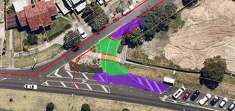
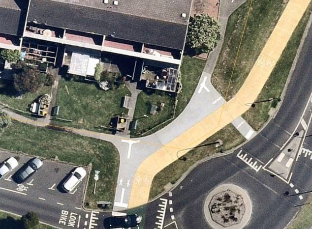
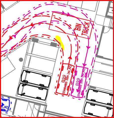
![]()
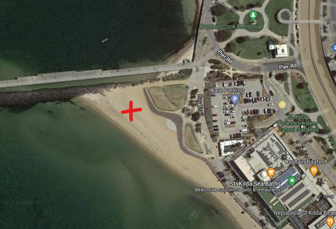
Image 1: Feel Good Yoga Flows allocated area under the permit/licence.
Compliance
FGF is currently operating outside it’s permit conditions. This has been highlighted in:
· The Age on 2 January 2024 where an article featured a 100 person yoga event hosted by Feel Good Flows on St Kilda Beach
· Conversations with the business owner who has indicated that there are regularly over 15 people present at their outdoor classes
· In photos which have been posted on the business’ website and social media, showing large numbers at gatherings, blocked pathways, drum kits and amplified music. These photos also show the operation is regularly set up on the all-access beach access pad, which is the only year-round access point for those with low mobility.
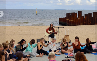
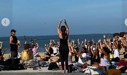
Image 2&3: FGF at St Kilda Beach - Source - Feel Good Flows – Facebook
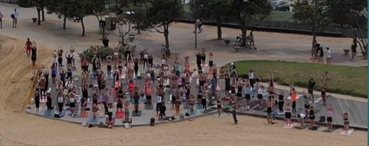
Image 4: FGF at St Kilda Beach - Source - Feel Good Flows Website
After a January new years day event which was found to be non-compliant, FGF was issued with a request to comply with their permit conditions, specifically to limit their operations to 15 participants and to conduct their activities in their permitted location (that does not include the adjoining boardwalk). This compliance warning was followed with a number of discussions and a meeting regarding the permit and alternatives for the business operations.
Options
Through these discussions, FGF have requested to continue operating with upwards of 50 participants per session, indicating that their model of operation could not restrict people at the sessions.
In Response to this information, the following options were provided to FGF:
· Continue with the existing licence and achieve compliance with the number of participants, by conducting multiple yoga sessions throughout the week, with up to 15 participants per session. This would provide access to yoga sessions for the same number of people overall, over an extended period of time, rather than 50 plus people in one session.
· Apply for an Event Permit running up to four large scale events over a 12 month period at a fee of $400 per event. Fee discounts are available if criteria can be met (see page 26 of the Outdoor Events Guidelines for this criteria).
· Consider a community facility. Council has a number of community facilities across the municipality which may be suitable and fee discounts could be sought if criteria is met. (All information for hiring community centres can be found on CoPP website Hire a venue - City of Port Phillip).
Current State
Currently the business has continued to run with numbers over 15, at both the St Kilda and Elwood Locations. With the exception of St Kilda Festival Sunday where all non-Festival related activities are excluded from the St Kilda area.
In the last week, FGF have entered into an agreement with St Kilda Sea Baths to provide classes on their rooftop. They are advertising bookings for these classes on their website and St Kilda Beach has been removed as a site.

Image 5: FGF booking information for St Kilda Sea Baths Location – source FGF website.
Recommendation Rationale
It is recommended that all activities within public space continue to operate under the current policy requirements. As:
· These policies have been put in place to balance the amenity of all users of public space against the benefits of the provision of outdoor health and wellness classes.
· The permits are in line with DEECA requirements, and the process provides for equitable usage.
· FGF is operating as a business providing a fee for use service in public space (along with some discounted/free options).
· It is difficult to manage the safety of all participating with large numbers. Safety could include ensuring participants are undertaking a safe practice and appropriate response to potential disruptive behaviour or situation.
· Removal of the numbers restriction for this business would create a precedent to other providers and for future businesses who apply to use the foreshore and public space.
It is therefore recommended that FGF are required to comply with the conditions within their permit at both locations (St Kilda and Elwood), including restricting classes to 15 people and operating in the designated locations (on the beach away from the pathways and all-abilities access pad).
|
That Council: 1. Receives and notes the petition. 2. Thanks the petitioners for their petition. 3. Acknowledges the community benefit that Feel Good Flows provides. 4. Notes the increasing pressure on public space to support commercial operators, particularly along the foreshore, and recognises the importance of public open spaces being shared by all community users. 5. Notes the provider can continue operations in line with their current licence, as per the Fitness Training Policy, with participant numbers of no more than 15 and within the allocated locations. 6. Requests officers to work with Feel Good Flows on the alternative options of four annual events or a community venue in line with relevant policies and guidelines. |
|
ATTACHMENTS |
Nil |
Meeting of the Port Phillip City Council
6 March 2024
7.2 Petition: Request for use of Elwood Primary School Reserve as an Off-Leash Dog Park
A Petition containing 96 signatures, was received from local members of the community.
The Petition states the following:-
We, the undersigned, are a Community of like-minded residents who want to exercise and socialise our dogs, off-leash, in a safe, local area each day.
The Clarke Street Reserve is local but is small, is not fenced and borders Mitford Street which has a lot of traffic especially during peak hours. It is not a safe off-leash area.
The Elwood Primary School Reserve however is a much larger area and is already fenced. It is used exclusively by the School during school hours but is an ideal area for more community use outside of those times.
We urge both the Council and Elwood Primary School to work together so that the Elwood Primary School Reserve becomes available as an off-leash dog park before 8:30am and after 4:30pm.
Of course, the School must have first use of the park and on the few occasions that they need after school access, off-leash dog activity would not be allowed.
We thank you for your consideration and look forward a positive response.
|
That Council: Receives and notes the Petition and provides a response to a future Council meeting. |
|
ATTACHMENTS |
Nil |
Meeting of the Port Phillip City Council
6 March 2024
7.3 Petiton: City of Port Phillip Rental Crisis
A Petition containing 5 signatures, was received from residents.
The Petition states the following:-
To the Mayor·and Councillors of the Port Phillip City Council,
We, the following named citizens of the City of Port Phillip (whose names, addresses, and signatures appear immediately below), were amongst 41 attendees at a public meeting concerning the local rental crisis held at the Betty Day Centre in St Kilda on November 21st, 2023.
The meeting agreed and resolved that we should petition the Council to assist and support its residents who are renting, or seeking to rent in the private sector, many of whom are facing problems finding a home, while encountering steep rent increases, security of tenure issues and difficulties with maintenance and repairs.
Nearly 50% of residents in Port Phillip are renters, and the meeting considered that it was time for Council to play a bigger role in addressing the needs of this group.
Accordingly, we have been assigned to petition Council to:
1. Establish an emergency rental relief fund for low income residents and partner with a relevant agency, such as Launch Housing to manage such a fund on behalf of Council.
2. Establish a dedicated page on the Port Phillip Council website that will provide information for renters about their rights and where they can access assistance and support.
3. Nominate a Council Housing Officer to provide support, information and advice for renters in Port Phillip and liaise with relevant local support agencies.
4. Re-establish financial support for Southside Justice to provide legal assistance for tenants facing eviction and/or unfair treatment at the hands of Landlords and Real Estate Agencies.
5. Ensure that there is a funding allocation in the next Council Budget to meet the costs associated with these initiatives.
6. Advocate to the State Government for introduction of a 'fairness formula' by which maximum rent increases would be calculated (as recommended by Tenants Victoria in their submission to the Victorian Government's recent Inquiry into the Rental and Housing Affordability Crisis).
7. Advocate to, and partner with, State and Federal Governments for substantial expansion of social housing (inclusive of public housing) in Port Phillip.
|
RECOMMENDATION That Council: Receives and notes the Petition and provides a response to a future Council meeting. |
|
ATTACHMENTS |
Nil |
Meeting of the Port Phillip City Council
6 March 2024
8.1 Presentation of December CEO Report - Issue 103..................................................................... 19
Meeting of the Port Phillip City Council
6 March 2024
|
Presentation of December CEO Report - Issue 103 |
|
|
Executive Member: |
Joanne McNeill, Executive Manager, Governance and Organisational Performance |
|
PREPARED BY: |
Jacky Bailey, Head of Corporate Planning |
1. PURPOSE
1.1 To provide Council with a regular update from the Chief Executive Officer regarding Council’s activities and performance.
2. EXECUTIVE Summary
2.1 In March 2014, the City of Port Phillip introduced a program of more regular performance reporting through the CEO Report.
2.2 The attached CEO Report – Issue 104 (Attachment 1) focuses on Council’s performance for January 2024.
|
That Council: 3.1 Notes the CEO Report – Issue 104 (provided as Attachment 1). |
4. OFFICER DIRECT OR INDIRECT INTEREST
4.1 No officers involved in the preparation of this report have any material or general interest in the matter.
|
ATTACHMENTS |
Meeting of the Port Phillip City Council
6 March 2024
9.1 Older Persons Advisory Committee Annual Report 2023 - For Endorsement....................... 25
Meeting of the Port Phillip City Council
6 March 2024
|
Older Persons Advisory Committee Annual Report 2023 - For Endorsement |
|
|
Executive Member: |
Tarnya McKenzie, Interim General Manager, Community Wellbeing and Inclusion |
|
PREPARED BY: |
Cathy Horsley, Team Leader Community Building |
1. PURPOSE
1.1 To present the Older Persons Advisory Committee (OPAC) Annual Report for 2023 for endorsement (Attachment 1) which informs Council of the achievements over the period January to December 2023.
2. EXECUTIVE Summary
2.1 The OPAC Annual Report 2023 documents the activity of the committee in 2023, including membership representation and nominations, retired members, monthly meetings, subcommittees and working groups, significant consultation and feedback activity, engagement with external groups and events.
2.2 In 2023, OPAC activities focused on supporting the endorsement and implementation planning of Council’s Positive Ageing Policy.
2.3 In 2023 OPAC provided significant support to Council providing feedback and consultation about the proposed changes to Aged Care Services in Port Phillip.
2.4 OPAC was established in 2000 as an outcome of the International Year of the Older Person and is the peak advisory and advocacy body on issues affecting the wellbeing of older people (55 years and over) within the Port Phillip municipality and seeks to provide advice to Council and its officers on policies, plans and services that affect older people and their interests, and encourage Council to advocate to other levels of government, this includes advocating for significant events, activities and services relating to older persons.
2.5 OPAC aims to be representative and advocate on behalf of older persons from our diverse community including people with disabilities, people who identify as lesbian, gay, bisexual, transgender, or intersex (LGBTI), people of Aboriginal or Torres Strait Island background, people experiencing financial disadvantage (including people who are homeless or at risk of homelessness) and our multicultural and multifaith communities.
2.6 This report seeks endorsement of the OPAC Annual Report 2023.
|
That Council: 3.1 Endorses the Older Persons Advisory Committee Annual Report 2023 (Attachment 1) 3.2 Recognises the value of work undertaken by the OPAC as the peak advisory and advocacy body on issues affecting the wellbeing of older people (55 years and over) within the City of Port Phillip. 3.3 Acknowledges the on-going work of the OPAC and thank the Committee for its efforts. |
4. KEY POINTS/ISSUES
4.1 In early 2023, OPAC members were key subject matter experts and stakeholders in the finalisation of the Council’s Positive Ageing Policy. OPAC provided advice and feedback about the design and content of the policy to make the policy a more user friendly and readable document by including case studies.
4.2 OPAC participated in three workshops with Community Services to provide feedback about the proposed Changes to Aged Care Services in Port Phillip. OPAC feedback was incorporated in the engagement collateral. In December 2023 OPAC provided a formal response to Council regarding Proposed Changes to Aged Care Services.
4.3 OPAC continued to advocate for older people through the draft Council Plan and Budget submission input process. This included advocating for activities and service improvements in areas aligned to OPAC key focus areas of positive ageing, ageism awareness, public spaces, wellbeing, physical environment, housing and housing insecurity, environmental sustainability, and Council communications.
4.4 OPAC provided feedback on a range of significant projects and plans including the Positive Ageing Policy, Accessibility Action Plan, Public Toilet Plan, E-Scooter Trial, Act and Adapt Sustainable Environment Strategy, Ten Year Integrated Transport Strategy, Places to Live: Port Phillip Housing Strategy.
Advice Highlighting Matters Affecting Older Residents
4.5 The OPAC has continued to consult on matters relevant to older people residing in the City of Port Phillip and deliberated on specific Council matters concerning older people. Community trends relevant to Council were identified through OPAC meetings where reports were provided from OPAC representatives. Key activities are listed below.
4.6 OPAC received regular updates from council officers regarding the Positive Ageing Policy endorsement and implementation in 2023. Deputy Chair Ian MacDonald, Coralie Ling and Rosemary Rule attended the Council meeting 17 May to speak in support of the endorsement of the Positive Ageing Policy and ask about implementation plans.
4.7 OPAC received regular updates from Council officers regarding proposed changes to Aged Care Services. OPAC were consulted as part of this process. OPAC participated in workshops on 20 October and 4 December where contributed feedback on the community engagement plan. OPAC submitted a response to the proposed Changes to Aged Care Services during the formal engagement period.
4.8 The OPAC 23/24 budget submission complimented the implementation of Positive Ageing Policy and Council’s review of delivery of Aged Care Services. The submission was further strengthened with the inclusion of resourcing indicators. The submission included the following items which were subsequently endorsed:
· Council offers a print and post option for Divercity by request.
· Funding to support older people to improve their digital literacy skills with classes in the community, partnering with libraries, tech organisations and community groups.
· Council’s Community Bus service return to a ‘Hop on Hop Off’ service.
· Request that the age at which community facilities fees are waived where 65% of attendees are aged over 65 be lowered to 60 years in line with the Positive Ageing Policy.
4.9 The OPAC Sport and Recreation Working Group worked with Council’s Sport and Recreation team to design a phone survey which was delivered to ten local sporting clubs.
4.10 OPAC instigated the inaugural Joint Special Advisory Committee Meeting held on 21 March, chaired by OPAC Chair Wendy Priddle. At the meeting members discussed the meeting purpose and opportunities for alignment including public events, website improvements and a possible joint budget submission where objectives align.
4.11 OPAC continued to raise awareness about ageism against older people and seek ways to end ageism. An Ageism Awareness Information session was delivered by Wendy Priddle on 15 June to 12 participants from local Aged Care service providers for World Elder Abuse Prevention Awareness Day (WEAAD). A further six sessions were conducted for Council staff in 2023, executive leadership and councillors on 26 October 2023.
OPAC Election of Office Bearers
4.12 At the meeting 6 February 2023 Freda Erlich and Coralie Ling resigned as Chair and Deputy Chair respectively having completed their term as outlined on the OPAC Terms of Reference. OPAC members were invited to nominate for the vacant positions. Nominations were open from 27 February to 3 March 2023. Six members were nominated, two members accepted their nomination, one for Chair, one for Deputy Chair.
4.13 At the meeting 6 March 2023 quorum was achieved and the two nominees were unanimously endorsed by members in attendance without the need for a vote.
The following members were elected at the 6 March meeting:
· Wendy Priddle - Chair
· Ian MacDonald - Deputy Chair.
Membership and Recruitment
4.14 As a result of the resignation of four members in 2022 and the passing of a member in 2023, OPAC membership reduced to eleven members, leaving six vacancies.
4.15 In May 2023 Council called for Expressions of Interest from people wishing to join the OPAC. This opportunity was promoted broadly to the community via digital distribution through existing networks, e-newsletters, Council website and social media platforms. Hard copies of information were also made available at St Kilda and Port Melbourne Assists and St Kilda and Port Melbourne Libraries.
4.16 Ten Expressions of Interest were received. The selection panel were impressed by the calibre of all applications and recommended five people join the committee. The five recommendations were presented to the OPAC for endorsement at the meeting 3 July 2023 and endorsed by Council at the meeting 19 July.
OPAC Activities and Engagement with External Groups and Organisations
4.17 State Member for Albert Park Nina Taylor attended the August and October OPAC meetings providing responses to question posed by the committee in relation to changes to Aged Care Services, management of social and affordable housing and took questions.
4.18 On 4 September the OPAC Statement on The Indigenous Voice to Parliament was endorsed by the committee.
4.19 Members of the OPAC Public Spaces and Physical Environment Working Group received a briefing from e-scooter providers Lime and Neuron in November. The working group shared feedback and raised concerns shared by older residents. The working group focused on patronage and usage, trip mapping, problems and accidents, improper parking, and failure to wear helmets.
4.20 Five OPAC members worked with TestMate agency to test the Council website useability and provide feedback to improve the website content and layout.
OPAC Events 2023
4.21 OPAC co-designed the 2023 City of Port Phillip Seniors Festival, held from 1 to 15 October. The festival included 35 Council and community led events and activities across the municipality with an estimated total attendance of over 1,700 people.
4.22 Acts and activities on offer in Port Phillip’s 2023 Seniors Festival included an Elvis tribute show to launch the festival, sport and recreation activities, community gardening, digital storytelling and art workshops, safety forums and healthy living seminars, cultural celebrations and an excerpt of The Nutcracker performed by students of the National Ballet School.
OPAC Governance – Development of Action Plan
4.23 Established in 2020 the OPAC Objectives and Planning Working Group developed the OPAC Action Plan for 2023. The Objectives and Planning Working Group meeting held on 16 January 2023 was made up of the OPAC Chair, Deputy Chair and eleven members of the OPAC who nominated to participate. Team Leader Community Building also attended/contributed to provide relevant information and administrative support.
4.24 The OPAC Governance Subcommittee was established in 2020 to support the OPAC to develop guidelines and processes to ensure OPAC meetings are running effectively and efficiently. Where appropriate it has a role in implementing decisions taken by OPAC.
4.25 In 2023 the Governance Subcommittee utilised the following tools to assist with its stated aim of efficient and effective operations:
· OPAC Governance Sub Committee Guidelines
· Guidelines for the establishment of OPAC Working Group and Sub-Committees
· Agenda setting and meeting procedures
· Consultation guidelines for council officers
· Process for introducing New Items for action by OPAC
· Procedure for Subcommittees and Working Groups.
5. CONSULTATION AND STAKEHOLDERS
5.1 The 2023 Annual Report has been prepared by staff in consultation with the OPAC Chairperson Wendy Priddle and Deputy Chairperson Ian MacDonald, and with input from committee members Freda Erlich, Coralie Ling, Sue McGowan, Neville Aphoy, Judith Armstrong, Betty Knight, Rosemary Rule, Liz Robson, Richard Whitfield, Ada Lubin, Jeanette Lyons, Janet Gardner, and Vasileios Tsialtas.
6. LEGAL AND RISK IMPLICATIONS
6.1 There are no known legal or risk implications.
7. FINANCIAL IMPACT
7.1 The OPAC Annual Report is written and produced by internal staff resources. There is no expense other than officer time associated with the production.
7.2 The budget allocation for the OPAC program for the financial year is $3,500. A full-time position allocates approximately 0.2 FTE of the role supporting the committee.
7.3 The OPAC are Port Phillip residents who provide their time and skills on a voluntary basis.
8. ENVIRONMENTAL IMPACT
8.1 The OPAC are committed to sustainability ensuring all catering provisions for monthly meetings adhere to Council’s sustainability guidelines.
8.2 Printing is kept to a minimum with most communication by email.
9. COMMUNITY IMPACT
9.1 The OPAC provides the opportunity for understanding good governance, community and civic participation and sharing of best practice to advocate for older people in the Port Phillip community.
9.2 The OPAC is a formal advisory group to Council and is supported and resourced by the Grants and Community Building Team. In 2023, sixteen local residents/committee members regularly attend meetings and organised events in the City of Port Phillip.
9.3 In 2023 the OPAC provided input via consultation on significant projects and plans including the Positive Ageing Policy, Proposed Changes to Aged Care Services Accessibility Action Plan, Public Toilet Plan, E-Scooter Trial, Act and Adapt Sustainable Environment Strategy, Ten Year Integrated Transport Strategy, Places to Live: Port Phillip Housing Strategy.
9.4 The OPAC are Port Phillip residents who participate on a voluntary basis. Participation and engagement with other Advisory Committees and external networks helps to build community connections.
9.5 OPAC members represented the following associations/networks and reported relevant activities at the OPAC monthly meetings; Elwood Croquet Club, Port Phillip Citizens for Reconciliation, University of the Third Age Port Phillip, Port Phillip Multifaith Network, Port Phillip Multicultural Advisory Committee, Linking Neighbours Leadership Group.
10. ALIGNMENT TO COUNCIL PLAN AND COUNCIL POLICY
10.1 Since 2000, the Older Persons Advisory Committee has been guided by and aligned to the strategic goals of each Council Plan.
10.2 The activities of this committee align with two of the Strategic Directions in the 2021-31 Council Plan:
Strategic Direction 1 – Inclusive Port Phillip, Initiatives:
We will provide client services and programs that are inclusive and accessible for all, including people who identify as LGBTIQA+, people with disability, people from culturally and linguistically diverse backgrounds, Indigenous backgrounds, and people experiencing homelessness.
We will partner with our Older Persons Advisory Committee, Youth Advisory Committee, Multicultural Advisory Committee, MultiFaith Network and establish other committees, where relevant, to ensure the diversity of our community’s experience is represented in decision-making.
Strategic Direction 5 – Well Governed Port Phillip, Initiatives:
We will provide opportunities for our community to participate in civic life and help share Council policy, services, programs, and decisions by facilitating engagement in line with Council’s Community Engagement Policy.
10.3 The OPAC Annual Report in 2023 documents OPAC’s ongoing support of the Council’s Positive Ageing Policy. Members of the OPAC were key subject matter experts and stakeholders in the development of the Positive Ageing Policy and provided advice and feedback on the community survey and the design of the finalised the policy in 2023. OPAC continue to provide feedback about the policy implementation.
10.4 The OPAC is a formal advisory group to Council, providing community members the opportunity to participate in civic life to inform Council decision making. The OPAC work with the Council to provide good governance for the benefit and wellbeing of its community.
11. IMPLEMENTATION STRATEGY
11.1 TIMELINE
11.1.1 If endorsed, the OPAC Annual Report will be presented to members at the April 2024 OPAC Meeting.
11.2 COMMUNICATION
11.2.1 If endorsed by Council the OPAC 2023 Annual Report will be made available to the community on the Council website including in an accessible version format.
12. OFFICER DIRECT OR INDIRECT INTEREST
12.1 No officers involved in the preparation of this report have any material or general interest in the matter.
|
ATTACHMENTS |
Meeting of the Port Phillip City Council
6 March 2024
10.1 Cowderoy Street Right Turn Restriction Trial... 35
10.2 Barak Beacon Public Housing Estate............... 43
10.3 Draft Housing Strategy and Phase 3 Community consultation..................................................... 103
10.4 City of Port Phillip Spatial Economic and Employment Framework (SEEF): Adoption.... 115
Meeting of the Port Phillip City Council
6 March 2024
|
Cowderoy Street Right Turn Restriction Trial |
|
|
Executive Member: |
Brian Tee, General Manager, City Growth and Development |
|
PREPARED BY: |
Noshin Tasnim, Transport Engineer Thomas Mason, Coordinator Transport Safety |
1. PURPOSE
1.1 To report on the findings of the evaluation of the Cowderoy Street No Right Turn Restriction Trial and recommend a permanent right turn restriction from Canterbury Road to Cowderoy Street between 4:30 – 6:30pm, Monday to Friday.
2. EXECUTIVE Summary
2.1 In 2022 Council received a request from the West St Kilda Residents Association (WSKRA) to investigate their long-standing concerns about excessive vehicle volumes and alleged rat running on Cowderoy Street, St Kilda West.
2.2 Traffic data subsequently collected on Cowderoy Street showed that the daily vehicle volumes were higher than the normal range for a local street.
2.3 Community consultation was undertaken in October 2022 to understand the level of community support for a trial of a no right turn restriction from Canterbury Road into Cowderoy Street during afternoon peak periods. The consultation found that 48.4% of the community supported the restriction and 51.6% were against it.
2.4 At the Council Meeting on 3 May 2023, Council considered the community feedback and endorsed a 6-month trial, key parts of the resolution are listed below:
· Notes that there is community desire to resolve evening peak hour rat running in the St Kilda West Area.
· Endorses a 6-month trial, between July – December 2023, of a no right turn restriction from 4:30 – 6:30pm, Monday to Friday from Canterbury Road to Cowderoy Street, St Kilda West.
· Requests that officers evaluate the 6-month trial and provide a report to Council on traffic measures required to further reduce the evening peak rat running in the St Kilda West Area.
2.5 The objectives of the Cowderoy Street No Right Turn Restriction Trial were as follows:
· Maintain safety for all road users.
· Reduce traffic volumes in Cowderoy Street.
· Limit impact of any redirected traffic volumes on the surrounding road network,
2.6 To support the evaluation of the trial, traffic data was collected before and during the trial to understand the impact of the proposal.
2.7 The traffic data obtained indicated:
· The daily traffic volume on Cowderoy Street reduced by approximately 25% from pre-trial counts with Cowderoy Street now operating with a more appropriate volume of cars considering its road classification.
· Traffic volumes in surrounding streets showed minimal fluctuations, with many streets experiencing relatively stable or only slight increases in traffic volumes indicating that the re-distributed traffic was absorbed across multiple surrounding streets as opposed to a single street.
· Where streets had observed increased traffic volumes the resulting daily traffic volume remained within the acceptable limits of their respective road classification.
· Vehicle speeds recorded during the trial were generally consistent with pre-trial data.
2.8 Council sought feedback from community members throughout the trial via an online Have Your Say survey. The feedback received had mixed views mainly dependant on where respondents lived in relation to the trial, with community members both supporting and not supporting the trial. The outcome of the community engagement is detailed in the Engagement Report included as Attachment 1.
2.9 Based on the assessment of the impact and effectiveness of the trial Council officers recommend the trial turn ban become permanent.
|
That Council: 3.1 Notes that the trial has proven to be successful with a reduction of traffic volumes on Cowderoy Street with limited impact to surrounding streets. 3.2 Endorses a permanent right turn restriction from Canterbury Road to Cowderoy Street between 4:30 – 6:30pm, Monday to Friday. 3.3 Advises the community of the outcome of the trial, next steps, and thanks them for their contribution. |
4. KEY POINTS/ISSUES
4.1 High traffic volumes and alleged “rat-running” have been long-standing issues for residents on Cowderoy Street. The West St Kilda Residents Association (WSKRA) has requested Council implement measures to improve residential amenity and reduce through traffic.
4.2 Cowderoy Street is classified as a local street. The function of a local street is to provide access to properties within the local area. A typical volume for a local street is between 500 to 3,000 vehicles per day.
4.3 Traffic counts by Council show that the average weekday traffic volume on Cowderoy Street in 2021 and 2022 exceeded 3,000 vehicles. Table 1. below shows the results of four different traffic counts conducted on Cowderoy Street in 2021 and 2022.
|
Cowderoy Traffic Conditions |
March 2021 |
April 2021 |
May 2021 |
March 2022 |
|
85th Percentile Speed (km/h) The speed at which 85% of vehicles travel at or below the speed limit |
41.9 |
43.1 |
44.4 |
43.2 |
|
Average Weekday Traffic Volume (vehicles per day) The average number of vehicles travelling in one weekday through the street (in both directions) |
3,504 |
3,218 |
3,092 |
3,226 |
Table 1 Traffic Survey Data - Cowderoy Street 2021 and 2022
4.4 Council, at its meeting of 19 October 2022, resolved to undertake a consultation with the local community on a potential 12-month trial to install a no right turn restriction to operate between 4:30 - 6:30pm on weekdays from Canterbury Road to Cowderoy Street; and to receive a further report on the outcome of the community consultation process, prior to determining if Council proceeds with the trial. The consultation found that 48.4% of the community supported the restriction and 51.6% were against it.
4.5 Council, at its meeting on 3 May 2023, endorsed a 6-month trial of a no right turn restriction between 4:30 and 6:30pm, Monday to Friday from Canterbury Road into Cowderoy Street in St Kilda West.
4.6 The trial was implemented on Tuesday 25 July 2023.
Trial Evaluation
4.7 The trial’s effectiveness was assessed using both qualitative and quantitative data including through an online survey on Council’s Have Your Say page, and the collection of transport data to analyse vehicle volumes and speeds on the surrounding road network before, during and at the conclusion of the trial.
4.8 The objectives of the trial are outlined below
· Maintain safety for all road users.
· Reduce traffic volumes in Cowderoy Street.
· Monitor impacts of any redirected traffic volumes on the surrounding road network
4.9 Traffic surveys were conducted during the following periods
· 5 – 12 June 2023 – pre-trial traffic counts to determine baseline
· 14 – 21 October 2023 – traffic counts at 3-month mark
· 15-22 December 2023 – traffic counts at 5-month mark
4.10 The following events may have impacted traffic survey volume data. However, officers are confident that the data collected is sufficient to adequately assess the effects of the trial.
· During the October surveys, two traffic count tubes were damaged. These locations were at McGregor Street and Langridge Street between Canterbury Road and Canterbury Place. To ensure valid results these counts were replaced and re-counted the following week therefore the impact was minimal.
· South East Water (SEW) construction works within the Middle Park area occurred between the 4th and 15th December 2023. The construction works involved work zones and road closures within Deakin Street and Cowderoy Street. The impact of these works on the traffic surveys were considered minimal.
· The December counts may have been impacted by the seasonal holiday period.
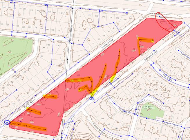
4.11 Locations where traffic surveys were undertaken are shown in Figure 1.
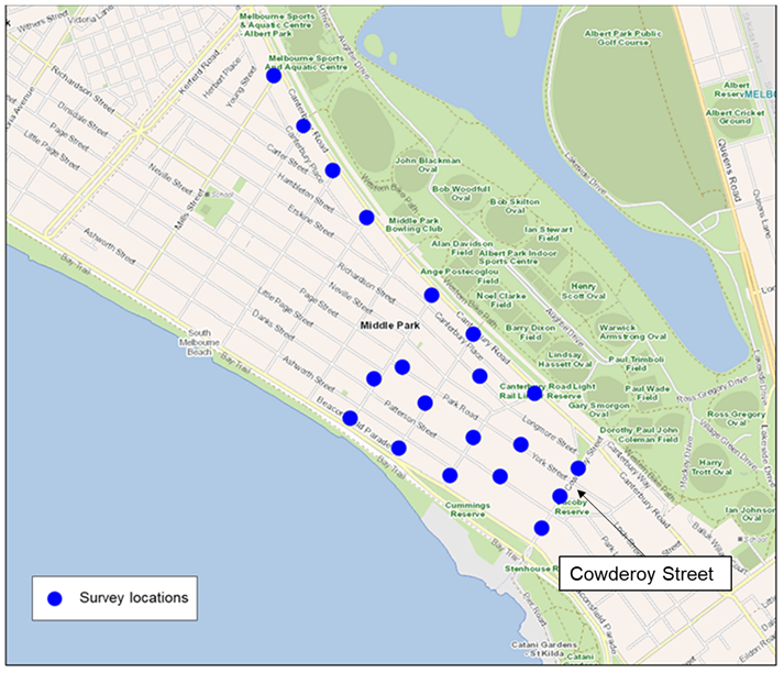
Figure 1 Traffic Counter Locations
4.12 Community consultation was undertaken to understand:
· Any impacts on access and amenity
· Community observations regarding vehicle behaviour (speeding, adhering to stop/giveaway signs)
· If the ban changed the community’s sense of safety
· Any unforeseen consequences
4.13 The objective of the trial was to support the amenity of local residents and reduce through traffic on local roads. Therefore, the analysis of the survey results involved differentiating responses between local residents and those outside the directly impacted area. Local residents were those who lived within the local area zone shown in below.
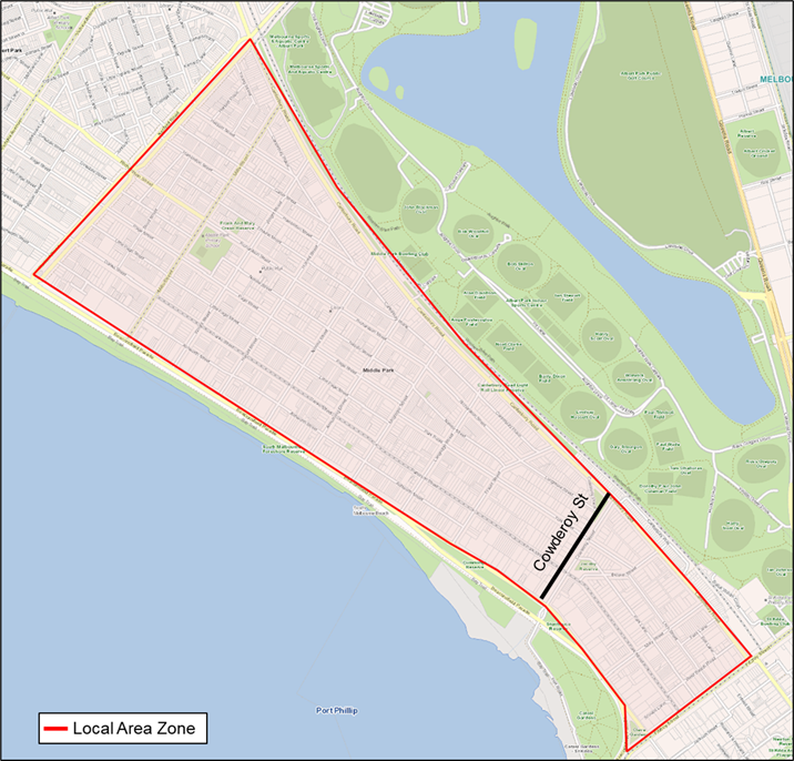
Figure 2 Local Area Zone
Trial Outcome – Traffic survey results
Objective 1 - Maintain safety for all road users.
4.14 The Road Crash Information System (RCIS) records the official number of crashes attended by Victoria Police. This database is typically updated bi-annually, the latest update being May 2023. Therefore, crash data during the trial period is not yet available.
4.15 The community informed Council of two crashes at the intersection of Langridge Street and Patterson Street. Victoria Police advise that these crashes were not attended and have not been officially recorded in the RCIS. As there is limited detail on the timing of these crashes, officers are not able to confirm whether the trial turn ban was a contributing factor of these crashes.
4.16 Officers are aware of the historic road safety concerns at the intersection of Langridge Street and Patterson Street. Motorists have been observed to regularly cross Patterson Street from Langridge Street without giving way in both directions. A project has been developed by officers to address the crash history at this intersection. This project is to be considered by Council in the 24/25 budget.
4.17 In June 2023 officers installed temporary speed cushions on Langridge Street, on approach to Patterson Street to address the safety concerns. Based on community feedback officers are aware that the temporary measures may not be sufficient, and officers are currently investigating additional interim treatments at this intersection to further address the safety issue.
4.18 The 85th percentile vehicle speeds during the trial were generally consistent with pre-implementation data showing little to no impact on the average speeds of vehicles.
Objective 2 - Reduce traffic volumes in Cowderoy Street.
4.19 Traffic data obtained on Cowderoy Street between Canterbury Road and York Street for the evaluation is summarised in Table 2.
|
Traffic survey date |
Average weekday traffic volume |
Average weekday volume between 4.30pm-6.30pm (Trial) |
|
June 2023 (pre-trial) |
2587 veh/day (Base line) |
559 veh/2 hours (Base line) |
|
October 2023
|
1902 veh/day
|
264 veh/2 hours
|
|
December 2023 |
2049 veh/day
|
281 veh/2 hours
|
Table 2 Summary of traffic data – Cowderoy Street
4.20 Cowderoy Street is now operating at a more appropriate volume considering its road classification and the number of properties along it.
Objective 3 - Impact of any redirected traffic volumes on the surrounding road network.
4.21 Traffic volumes in surrounding streets generally showed minimal fluctuations, with many streets experiencing relatively stable or slightly increased traffic volumes.
4.22 Before the trial there were concerns that redistributed volumes would transfer to the next available side street. To assess this, officers closely monitored the fluctuation of vehicle volumes in parallel streets to Cowderoy Street. Specifically, vehicle volumes travelling from Canterbury Road toward Beaconsfield Parade.
4.23 The data indicates that the redistributed traffic was dispersed across multiple streets as opposed to a single street. This data is presented in Figure 3. This data is compared to the volumes recorded on Cowderoy Street before the trial for context.
Figure 3 One way traffic volume of Cowderoy Street and surrounding streets
4.24 Of the surveyed locations Fraser Street and Langridge Street saw the greatest increases in one-way traffic volumes between the hours of 4:30-6:30PM, with an increase of 122 and 120 vehicles respectively, traveling south off Canterbury Road compared with baseline data from June.
4.25 The total average weekday volume on Fraser Street was observed to be 1289 veh/day (15% increase from baseline June 2023 volumes) in October and 1407 veh/day (26% increase from baseline) in December 2023. This daily traffic volume remains mid-range of the typical volume for a local street.
4.26 The total average weekday volume on Langridge Street was observed to be 1827 veh/day (58% increase from baseline June 2023 volumes) in October and 1815 veh/day (57% increase from baseline) in December 2023. This daily traffic volume remains mid-range of the typical volume for a local street.
4.27 In summary, the objective to reduce traffic volumes to acceptable levels for a local street on Cowderoy Street has generally been met with limited impact to surrounding streets.
Non-compliance
4.28 Some non-compliance to the restriction was observed by Victoria Police and the community particularly at the start of the trial as drivers adapted to the changed traffic conditions.
4.29 To assist with compliance of the right turn restriction, Officers reached out to Google Maps to ensure journey mapping and directions aligned with the trial ban. Google Maps has since been updated to exclude the right turn into Cowderoy Street from Canterbury Road as a route option between 4:30 and 6:30 PM on weekdays in line with the trial ban.
4.30 A survey on the 11th October 2023 with no Police presence showed that during the restriction period of 4:30-6:30 PM, 171 vehicles turned right from Canterbury Road to Cowderoy Street.
4.31 Non-compliance often occurs when new road restrictions are introduced as drivers become accustomed to the change. To understand compliance over a longer period of implementation, turning movement counts were undertaken on 22 February 2024 at Canterbury Road intersections with Mary Street and Deakin Street. These intersections currently have similar right turn restrictions. During the restriction period (4:30-6:30 PM) Mary Street saw 35 vehicles turn right from Canterbury Road and Deakin Street saw 25 vehicles.
4.32 Victoria Police have been attending the site regularly to enforce and monitor the turn ban trial. Officers will continue to seek Vic Police support should the trial be made permanent.
4.33 The limited time ban means no physical infrastructure can be put in place to physically restrict the movement.
Trial Outcome – Survey Results
4.34 The HYS survey had a total of 161 responses. Of the responses the following demographics were noted:
· 9% were Cowderoy Street residents.
· 83% were local residents (not including residents on Cowderoy Street).
· 8% of respondents were from the wider community.
4.35 A review of the open-ended comments found the following key themes:
4.35.1 The trial has reduced traffic volumes on Cowderoy Street, resulting in a safer environment for pedestrians and active transport.
Officer response: The review of traffic data confirms that the trial has been successful in reducing traffic volumes along Cowderoy Street.
4.35.2 Traffic volumes were reported to have increased in streets excluding Cowderoy Street and vehicles were observed to be speeding.
Officer response: The review of traffic data during the trial found that, where streets had increased traffic volumes, the resulting daily traffic volume remained within the acceptable limits of their respective road classification. Vehicle speeds recorded during the trial were generally consistent with pre-trial data.
4.35.3 Request for additional road safety treatments on streets where there is a perceived increase in traffic volumes and speeds.
Officer response: Based on the traffic data obtained and site investigations conducted, no immediate treatments to address the impacts of redistribution are warranted. Officers will continue to monitor all streets that may be affected by the right turn ban on Cowderoy Street should Council determine to make it permanent.
4.35.4 Can additional right turn restrictions be considered on other side streets off Canterbury Road, including Fraser Street, Langridge Street and McGregor Street.
Officer response: While officers understand the community desire for a broader approach including further turn bans, Officers propose an iterative approach to balance the impact of reducing local access against the need to protect residents in local streets from unacceptable traffic impacts.
5. CONSULTATION AND STAKEHOLDERS
5.1 In May 2023 a letter was sent to the 3875 local residents informing them of the Council endorsed 6-month trial of the right turn restriction ban.
5.2 A postcard detailing how to provide feedback on the trial was then sent to the same residential properties during the week beginning 14 August 2023.
5.3 Neighbourhood Engagement Pop Up was conducted at the corner of Armstrong Street and Erskine Street, Middle Park in November 2023 which included information on the trial and survey.
5.4 Officers met with WSKRA to discuss the trial in June 2023.
5.5 Cowderoys Dairy and Frankies Top Shop are two local business along Cowderoy Street. Both business close by 3pm on weekdays and are minimally impacted by the right turn restriction ban
5.6 The community requested the ability for bicycles to turn right at the intersection of Cowderoy Street and Canterbury Road at all times. Officers responded by installing a ‘Bicycles Excepted’ sign to allow bicycle movements.
5.7 A detailed summary of community feedback can be found in Attachment 1
6. LEGAL AND RISK IMPLICATIONS
6.1 Department of Transport is the road authority responsible for management of declared roads such as Canterbury Road, Fitzroy Street north of Canterbury Road and Beaconsfield Parade.
6.2 City of Port Phillip is the road authority responsible for management of local roads including Cowderoy Street within St Kilda West.
6.3 Victoria Police are the enforcement agency responsible for enforcing the Road Safety Road Rules 2017.
7. FINANCIAL IMPACT
7.1 Should the trial be made permanent there would be negligible financial impact to Council - on the basis no additional signage is required.
7.2 Should the trial be endorsed to be removed this work would be able to be accommodated in existing budgets.
8. ENVIRONMENTAL IMPACT
8.1 The proposed changes to the road network may result in some people choosing to travel by active or public transport, reducing greenhouse gas emissions.
8.2 Reduced traffic on Cowderoy Street will improve the safety and amenity of the street, which may result in more people choosing to walk or cycle for local trips.
9. COMMUNITY IMPACT
9.1 A permanent no right-turn restriction on Canterbury Road will reduce southbound traffic volumes and is likely to improve the amenity of residents on Cowderoy Street during evening peak hours.
9.2 The restriction is likely to redirect some traffic onto the surrounding local road network. While capacity is available to support this increase, this may lead to amenity impacts for residents in other streets.
10. ALIGNMENT TO COUNCIL PLAN AND COUNCIL POLICY
10.1 The Cowderoy Street No Right Turn Restriction Trial aligns to Strategic Direction 2 of the Council Plan 2021-31: Liveable: Port Phillip is a great place to live, where our community has access to high quality public spaces, development and growth are well managed, and it is safer and easy to connect and travel within.
11. IMPLEMENTATION STRATEGY
11.1 TIMELINE
11.1.1 If endorsed the signage installed for the trial is consistent with signage required to make this restriction permanent. Minor amendments to signage will be investigated to ensure clear visibility of the restriction and to minimise non-compliance.
11.1.2 Officers will continue to monitor surrounding streets for significant increases in traffic volumes and crashes.
11.1.3 Victoria Police will be notified of the outcome and their presence requested in an ongoing capacity to enforce the restriction if required.
11.1.4 If the recommendation to convert the trial infrastructure to permanent is not endorsed by Council the trial infrastructure including all signage would be removed as soon as possible within existing budgets.
11.2 COMMUNICATION
11.2.1 WSKRA and survey respondents will be notified of this report to be tabled at the Council meeting.
11.2.2 The outcome of the council meeting will be communicated to all stakeholders via letters and an update on the webpage.
11.2.3 Key messages will depend on the motion endorsed by Council but may include:
· The trial of right turn restriction at the intersection of Cowderoy Street and Canterbury Road has proven to be successful with a reduction of traffic volumes on Cowderoy Street with limited impact to surrounding streets.
· Council will continue to investigate options to make local streets as safe as they can be and reduce through traffic where possible.
12. OFFICER DIRECT OR INDIRECT INTEREST
12.1 No officers involved in the preparation of this report have any material or general interest in the matter.
|
ATTACHMENTS |
1. Cowderoy Steet-No Right Turn Restriction Trial
Enagement Report |
Meeting of the Port Phillip City Council
6 March 2024
|
Barak Beacon Public Housing Estate |
|
|
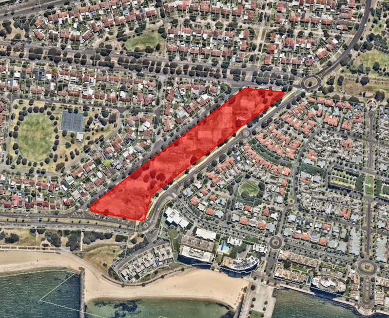
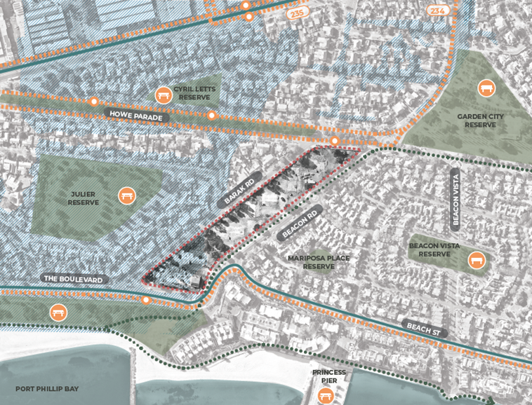
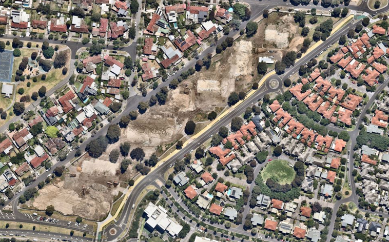
location/address: |
1/16 Barak Road, Port Melbourne |
|
Executive Member: |
Brian Tee, General Manager, City Growth and Development |
|
PREPARED BY: |
Larry Parsons, Manager City Development |
1. PURPOSE
1.1 To provide a Council position on an application to the Minister for Planning c/- Homes Victoria under Clause 52.20 (Victoria’s Big Housing Build) of the Port Phillip Planning Scheme for 1/16 Barak Road, Port Melbourne (Barak-Beacon Public Housing Estate).
2. EXECUTIVE SUMMARY
|
Ward: |
Gateway |
|
Trigger for determination |
1/16 Barak Road, Port Melbourne |
|
ApplicATION NO: |
PDLM/00159/2023 |
|
Applicant: |
Homes Victoria |
|
Existing use: |
Former mid-rise public housing estate, site has recently been completed cleared. |
|
Abutting uses: |
A mixture of dwelling stock ranging from detached single dwellings, up to apartment buildings typology. |
|
Zoning: |
General Residential Zone – Schedule 1 (GRZ1) |
|
Overlays: |
Special Building Overlay – Schedule 1 (SBO1) |
|
ABORIGINAL CULTURAL HERITAGE: |
Yes |
|
TIME FOR RESPONSE: |
20 days = 25 February 2024 (extended to 7 March 2024) |
Strategic Planning Matters
2.1 Gazetted on the 1st of December 2020, Amendment VC190 introduced a new provision into all Victorian Planning Schemes. Titled ‘Victoria’s Big Housing Build’, Clause 52.20 of the Victoria Planning Provisions was gazetted to facilitate the planning process for the development of housing projects by or on behalf of the Chief Executive Officer, Homes Victoria.
2.2 The Minister for Planning, rather than Council, will assess and approve these planning proposals. Planning requirements are confined to matters such as external amenity impacts, internal residential amenity and car parking. The process has a simplified consultation process allowing community and council feedback but does not allow any appeals of a decision.
2.3 Victoria’s Big Housing Build program is a $5.3 billion investment in social and affordable housing, delivering over 12,000 new dwellings:
· including 9,300 new social housing dwellings
· replacing 1,100 existing dwellings.
The investment, delivered throughout metropolitan and regional Victoria, will boost total social housing supply by 10%.
2.4 Council at its meeting on 19 October 2022, Council adopted the “City of Port Phillip Guiding Principles for Victorian Government public housing projects within the municipality” (‘Guiding Principles’) as follows:
1. Strategic alignment - Projects reflect the values of social equity, diversity and inclusion and have alignment with Council strategic policy directions.
2. Social housing yield - Projects deliver a net increase in social (public and community) housing dwellings and do not reduce the overall number of new bedrooms provided. The people accommodated on the site are increased, resulting in a reduction in the public housing waitlist. Projects are retained in public ownership.
3. Dwelling mix - Projects deliver a mix of housing types, sizes and tenures that meet the needs of existing and future residents and diverse households and needs groups, including families.
4. Projects ensure that different housing types are integrated and visually indistinguishable, with all residents benefitting from equitable access to residential amenity.
5. Holistic consideration of resident needs - Projects integrate health and wellbeing into design, provide opportunities for social connections, include measures to minimise the cost of living, maintain or improve access to public transport, local services and employment and provide potential for on-site resident support services and social enterprises.
6. Design excellence - Projects deliver a high-quality built environment, universal housing design outcomes and high amenity within buildings and outdoor spaces.
7. Sustainability - Projects incorporate best-practice environmentally sustainable design and respond to climate change impacts, including minimising operating costs for residents.
8. Neighbourhood integration - Projects integrate with the surrounding community and public realm, retain valued vegetation and features, prioritise walking and cycling and manage potential impacts on the surrounding community, including amenity, traffic and parking.
9. Broader public benefit - Projects provide quantifiable benefits to the surrounding community, such as public open space, community facilities and/or spaces for not-for-profit organisations and service organisations that support the local community.
10. Council jurisdiction - Projects manage demand and impacts on Council infrastructure, facilities and services including open space.
2.5 Council officers applied the Guiding Principles in formulating input to Victorian Government public housing projects within the City of Port Phillip.
Application Matters / Background
2.6 This report considers an application referred to Council from Minister for Planning c/ Homes Victoria under the Victoria’s Big Housing Build’ process to construct four (4) new buildings, varying in height from four (4) to eleven (11) storeys, containing 408 dwellings, comprised of 130 social housing dwellings, 82 affordable dwellings, and 196 market dwellings, all of which are ‘build to rent’, to be assessed under Clause 52.20 (Victoria’s Big Housing Build).
2.7 The application site is in the suburb of Port Melbourne in the Gateway ward of the City of Port Phillip (CoPP).
2.8 Under Clause 52.20-2 an application is exempt from the requirement to ‘obtain a permit or any provision of this planning scheme that prohibits the use or development of land, requires the use or development of land to be carried out in a particular manner, or requires a specified thing to be done to the satisfaction of a specified person or body, does not apply to any use or development this clause 52.20 applies to if requirements of clause 52.20 are met’.
2.9 Accordingly, the Minister for Planning is the Responsible Authority for an application that meets the requirements of Clause 52.20-3 of the Port Phillip Planning Scheme, which is the case in this instance.
2.10 Council received a pre-application request from the Victorian State Government in October 2023, seeking preliminary advice on the then development plans for the Barak Beacon Site.
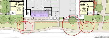
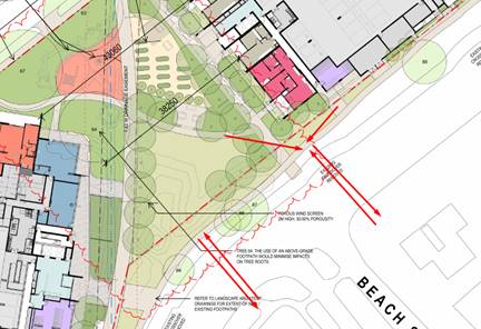
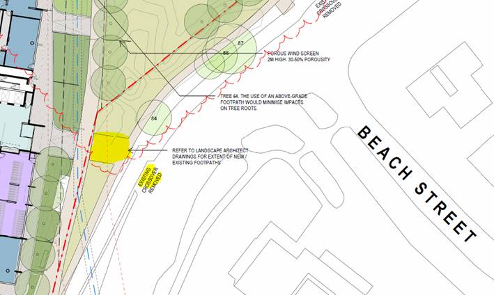
2.11 On review of the development plans Council provided initial feedback via a letter on 29 October 2023, which covered the key areas of concern; site response and massing, urban design, overshadowing impacts, pedestrian and vehicle access, parking ratios, open space tree retention, and housing diversity.
2.12 Homes Victoria provided updated plans and documents in response to Council’s feedback on 6 December 2024. After further review Council provided further comment on 23 December 2024, the matters raised again related to urban design, pedestrian and vehicle access, extent of vegetation removal, and overshadowing of the public realm.
2.13 Council received the public engagement documentation on 5 February 2024 with 20 days to respond to the Minister for Planning via Homes Victoria. In this time a full set of internal referrals have been provided as referenced in this report. This response is Council’s sole opportunity to comment formally on the proposal, with no third party appeal rights provided by the specific regulation of Clause 52.20 of the Planning Scheme. At officers’ request, Homes Victoria extended the response time for the City of Port Phillip to 7 March 2024, which permits consideration at a Council meeting on 7 March 2024. Beyond this date Council input is at risk of not being considered by the Minister. This timeline does not allow for the proper consideration of the issues by Council and may risk suboptimal outcomes. Noting that Council has also received very difficult timelines in relation to Fishermans Bend, officers will advocate to the State Government for a more realistic timelines to ensure all issues are properly identified and addressed.
|
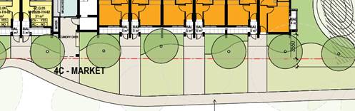
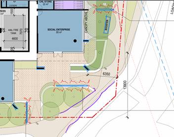
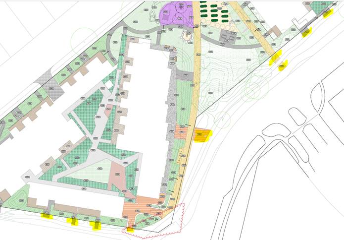
3.1 That the Council delegate advise the Minister for Planning c/- Homes Victoria that Council: 3.1.1 Does not support the following aspects of the development (as further detailed in this report): · The front setbacks of Buildings 2 and 3 to Barak Road. · The rear setbacks of Buildings 2 and 3 to Beacon Road. · The extent of hard surface and lack of planting opportunities along the eastern elevation of Building 4. · Lack of integration of the internal pathways to Beach Street (including pedestrian crossing across Beacon Road) · The low number of three or more bedroom apartments identified as a core housing requirement through the Council area. · The internal amenity of the studio apartments as outline in Section 10 of this report. · The lack of replacement canopy tree planting, particularly along the east and west boundaries. · Failure to provide the internal communal open space areas required. · Further consideration required regarding parking provision, especially for larger dwellings, and regarding vehicle swept path issues in the car park. · Revision of wind mitigation measures to reduce their visual and amenity impact. All other aspects of the proposal including traffic, sustainable design and waste management are generally acceptable subject to receipt of more detailed information which may result in minor changes to the proposal. These design and operational concerns need to be addressed or conditioned in any permit to be issued. |
4. PROPOSAL
4.1 Homes Victoria will oversee the delivery of new housing through a Ground Lease Model, in which the State Government will lease the land to a not-for-profit group (Building Even Better Communities) who will finance, design and construct the new housing. The redevelopment of the Barak-Beacon Public Housing Estate forms part of a broader Government initiative.
4.2 The redevelopment of the Barak Beacon site will replace 89 older style social dwellings with 408, social, affordable and market rental homes as well as provide specialist disability accommodation. The redevelopment will achieve a 46% increase in social housing over the former site conditions, and a more diverse rental housing stock designed to better meet the needs of the Port Melbourne community.
4.3 Under the lease with Homes Victoria, the community housing provider (Building Even Better Communities) will manage and maintain the site for 40 years, before handing the land and all dwellings back to Homes Victoria.
4.4 The application proposes to:
· Construct four (4) new buildings (known as buildings 1, 2, 3 and 4), varying in height from four (4) to eleven (11) storeys, containing 408 dwellings, comprised of 130 Social Housing dwellings, 82 Affordable dwellings, and 196 Market Dwellings, all of which are ‘build to rent’, and meet the requirements to be assessed under Clause 52.20 (Victoria’s Big Housing Build).
· The site contains 249 car spaces, of which 10 are DDA compliant.
· 519 bicycle spaces, including 445 secure, and 74 visitor spaces are scattered throughout the site.
4.5 More particularly, the built form proposal is comprised as follows:
Building 1 (including tower 1A and 1B)
Built form
· Two tower forms above a two to four storey podium and mezzanine level carpark.
· Tower 1A: 9 storey building (maximum height 31.4 metres - excluding roof top services)
· Tower 1B: Partially 10, partially 11 storey building (maximum height 37.6 metres - excluding roof top services)
Building Setbacks
· 1.9 to 3.1 metres to the south boundary at ground (2.2 to 3 metres above)
· 4 to 6.7 metres to the west boundary (same setbacks above).
· 7.5 to 12.9 metres to the east boundary at ground (6.3 to 9.3 at upper levels).
Building layout
· Two residential lobby areas one presenting to the east, the other west.
· Each lobby contains, a dual lift core and fire escape.
· Central carparking over 3 storeys (including mezzanine level).
· Tower 1A: contains 97 social dwellings.
· Tower 1B: contains 93 market dwellings.
· 78 square metre multi-purpose space on ground floor north-east.
· 56 square metre food and beverage tenancy on ground floor north-east.
· 85 square metre social enterprise on ground floor south-east.
· 79 square metre office for CHL on ground floor south-east.
Parking and Bicycle Provision
· Carparking over 3 storeys (including mezzanine level).
· Parking Spaces: 112 resident spaces, and 6 DDA compliant spaces (total spaces 118).
· Bicycle Spaces: 201 secure resident spaces, and 26 visitor spaces (total 227).
Podium landscaped area located centrally between the tower forms.
Building 2 (including mid-rise tower 2A and 2B)
Built form
· Two low scale building forms above a single storey podium.
· Building 2A: Five (5) storeys (maximum height 17.8 metres - excluding roof top services)
· Building 2B: Four (4) storeys (maximum height 14.4 metres - excluding roof top services)
Building Setbacks
· 1 to 4.2 metres to the east boundary (upper levels 3.65 to 4.2 metres excluding emergency stairwell)
· 1.65 to 3.8 metres to the west boundary (upper levels 3.65 to 5.9 metres).
Building layout
· Two residential lobby areas one presenting to the north, the other south.
· The southern lobby contains, a dual lift core and fire escape.
· The northern lobby contains, a single lift core and fire escape.
· Central at grade carparking area, with mezzanine level above.
· Collectively they contain: 44 affordable dwellings, and 31 market dwellings.
· Vehicle access from west elevation off Barak Road.
Parking and Bicycle Provision
· Carparking over 1 storey (under mezzanine level).
· Parking Spaces: 35 resident spaces, and 4 DDA compliant spaces (total spaces 39).
· Bicycle Spaces: 80 secure resident spaces, and 16 visitor spaces (total spaces 96).
Building 3 (including mid-rise tower 3A and 3B)
Built form
· Two low scale building forms above a single storey podium.
· Building 3A: Four (4) storeys (maximum height 14.7 metres - excluding roof top services)
· Building 3B: Four (4) storeys (maximum height 14.2 metres - excluding roof top services)
· Two (2) storey ‘townhouse’ style apartments to the north facing Barak Road.
Building Setbacks
· 1.2 to 4.1 metres to the east boundary.
· 3.8 metres to the west boundary (upper levels 3.8 to 5.3 metres).
Building layout
· Two residential lobby areas one presenting to the north, the other south.
· Both lobbies contain, a single lift core and fire escape.
· Central at grade carparking area, with mezzanine level above.
· Collectively they contain: 35 affordable dwellings, and 37 social dwellings.
· Vehicle access from west elevation off Barak Road.
Parking and Bicycle Provision
· Carparking over 1 storey (under mezzanine level).
· Parking Spaces: 41 resident spaces, and no DDA compliant spaces (total spaces 41).
· Bicycle Spaces: 78 secure resident spaces, and 16 visitor spaces (total spaces 94).
Building 4 (including mid-rise towers 4A, 4B and 4C)
Built form
· Three separate building forms connected via a podium landscaped area.
· Building 4A: Four (4) storeys comprising a mix of market and affordable dwellings.
· Building 4B: Two (2) storey comprising market dwellings in a townhouse typology
· Building 4C: Four (4) and Five (5) storey building comprising market dwellings
Building Setbacks
· 3.35 to 4.4 metres to the east boundary (same at upper levels).
· 2.9 to 3.6 metres to the west boundary at ground level (upper levels 2.9 to 3 metres).
· 3.35 to 27.5 metres to the north boundary.
Building layout
· Two residential lobby areas one presenting to the north and east, the other to the south and west.
· The south lobby contains, a single lift core and fire escape.
· The northern lobby contains, a dual lift core and fire escape.
· Central at grade carparking area, with mezzanine level above.
· Tower 4A: contains 32 market dwellings.
· Tower 4B: contains 6 market dwellings.
· Tower 4C: contains 37 market dwellings.
· Vehicle access from west elevation off Barak Road.
Parking and Bicycle Provision
· Carparking over 1 storey (under mezzanine level).
· Parking Spaces: 45 resident spaces, and no DDA compliant spaces (total spaces 45).
· Bicycle Spaces: 86 secure resident spaces, and 16 visitor spaces (total spaces 102).
Overall Development
Total number of dwellings, dwelling types, and commercial floor space
Total Parking Provision on site
Total Bicycle Provision on site
Materials and Finishes
A mixture of white and mid to dark brown shades of concrete and cladding finishes, with powder coated metal panels, louvers and canopies throughout.
The complete list of materials are as follows:

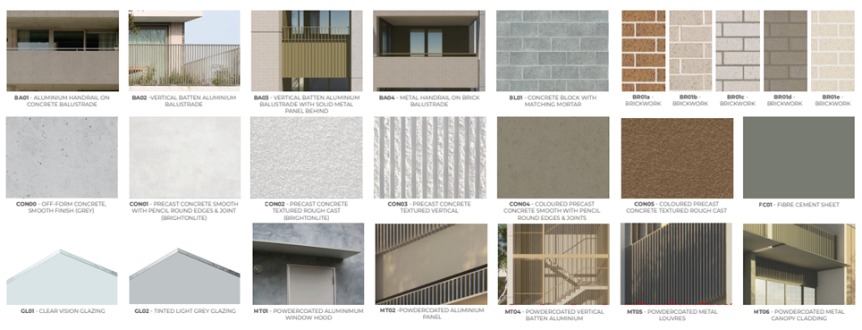
Materials Schedule examples
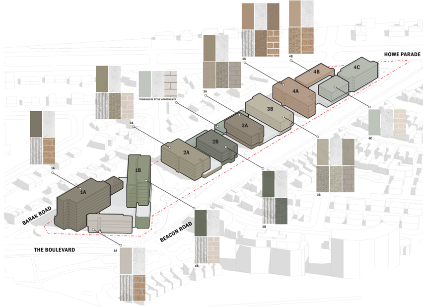
Materials Schedule Schematic.
Housing Types Explained (extract of Homes Victoria Website)
Social housing
Social housing is an umbrella term that includes both public housing and community housing. It generally indicates housing that involves some degree of subsidy.
Public housing is housing owned and managed by Homes Victoria. The government provides public housing to eligible Victorians including:
people who are unemployed.
· on low incomes.
· live with a disability or a mental illness.
· or who are at risk of homelessness.
Affordable housing
Affordable housing is a broad term describing housing suitable for the needs of a range of low to moderate income households and priced (whether bought or rented) so these households can meet their other essential living costs.
Under the program, rents in metropolitan Melbourne are set at least 10 per cent below the area’s median market rent, with the added protection of a cap set at 30 per cent of the median income.
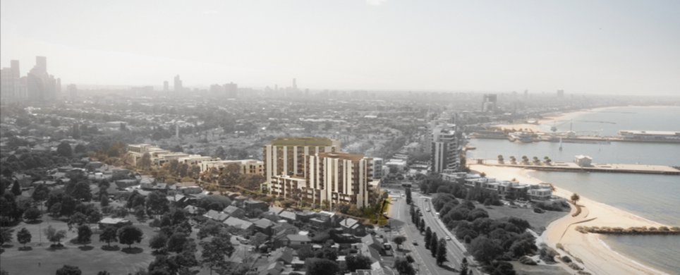
Figure 1: 3D Render of development (western view)
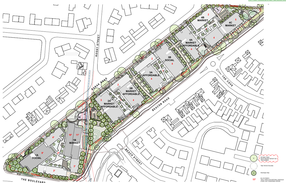
Figure 2: Overall site plan, including building numbers and floor levels.
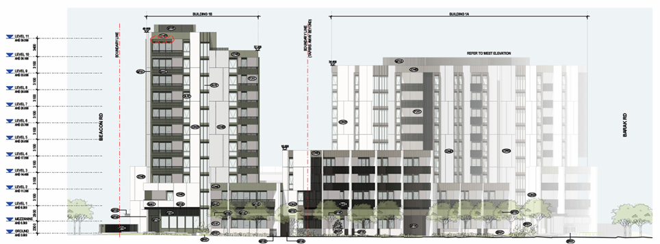
Figure 3: South Elevation of Building 1 as viewed from the Boulevard.
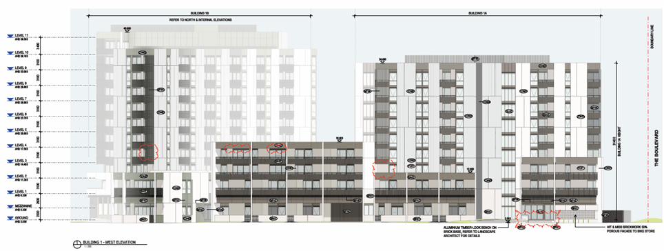
Figure 4: West elevation of Building 1 as viewed from Barak Road.
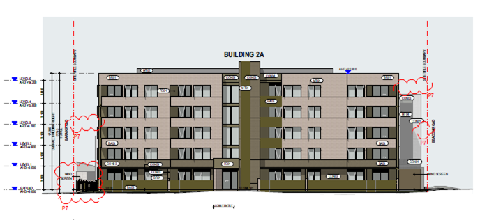
Figure 5: West elevation of Building 2 as viewed from Barak Road.
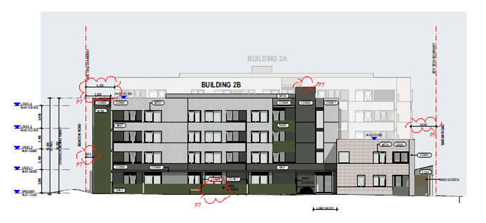
Figure 6: East elevation of Building 2 as viewed from Beacon Road.
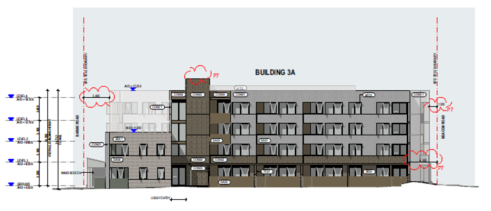
Figure 7: West Elevation of Building 3 as viewed from Barak Road.
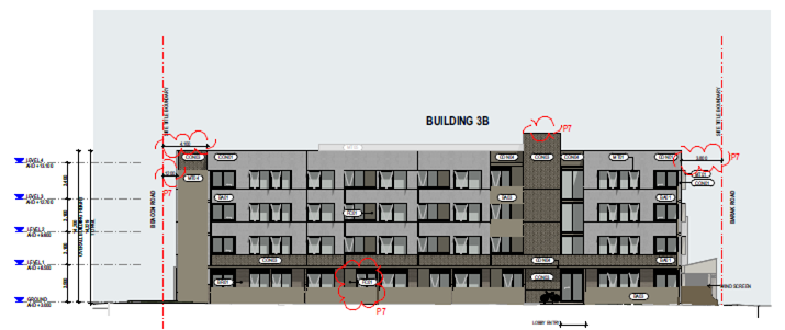
Figure 8: East elevation of Building 3 as viewed from Beacon Road.
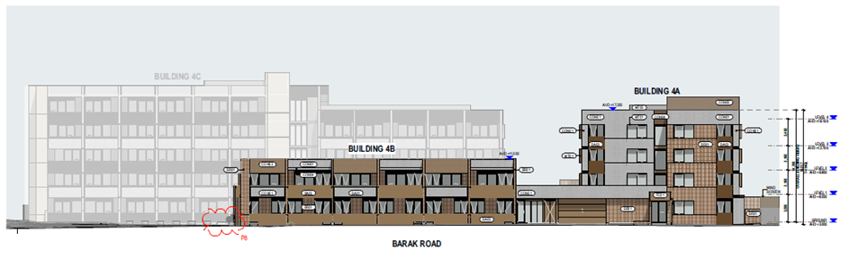
Figure 9: West Elevation of Building 4 as viewed from Barak Road.
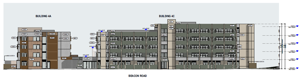
Figure 10: East elevation of Building 4 as viewed from Beacon Road.
Table 4.1: Assessed Documents Summary
|
Proposed Plans |
Development Plans prepared by Hayball and referred to as Project No. 2698 Drawing Nos. POR-A-TP-1-00-000 to POR-A-TP-1-00-002 (Rev P4), POR-A-TP-1-01-002 to POR-A-TP-1-01-013 (Rev P7), POR-A-TP-1-01-A000 to POR-A-TP-1-01-A012 (Rev P6), POR-A-TP-1-01-B000 to POR-A-TP-1-01-B005 (Rev P7), POR-A-TP-1-01-C000 to POR-A-TP-1-01-C004 (Rev P7), POR-A-TP-1-01-D000 to POR-A-TP-1-01-D005 (Rev P7), POR-A-TP-1-02-000 to POR-A-TP-1-02-009 (Rev P7), POR-A-TP-1-02-010 to POR-A-TP-1-02-013 (Rev P7), POR-A-TP-1-10-001 (Rev P4), POR-A-TP-1-10-11 (Rev P4), POR-A-TP-1-10-011A (Rev P4), POR-A-TP-1-10-014 (Rev P5), POR-A-TP-1-10-014A (Rev P4), POR-A-TP-1-10-015 (Rev P4), POR-A-TP-1-10-015A (Rev P4), POR-A-TP-1-10-033 (Rev P4), POR-A-TP-1-10-033A (Rev P4), POR-A-TP-1-10-041A (Rev P5), POR-A-TP-1-10-049 (Rev P1) and POR-A-TP-1-20-001 (Rev P5) – 61 sheets in total. Landscape Plans prepared by GLAS Landscape Architecture and referred to as Project No. POR-L-1-001 (Rev P3), POR-L-1-005 (Rev P3), POR-L-1-050 (Rev P3), POR-L-1-100 to POR-L-1-103 (Rev P3), POR-L-1-150 (Rev P3), POR-L-1-200 (Rev P3), POR-L-1-250 (Rev P3), POR-L-1-255 (Rev P3), POR-L-1-700 (Rev P3), and POR-L-1-701 (Rev P3). |
|
Supporting Documents |
· Tree Protection Management Plan (Rev A1), dated 19 January 2024, prepared by Ironbark Environmental Arboriculture. · Pedestrian Wind Environment Statement (Rev 4), dated 12 January 2024, prepared by Windtech. · Pedestrian Wind Environment Study (Rev 1), dated 29 January 2024, Prepared by Windtech. · Access Report (Rev B) – Town Planning (Accessibility), (Revision 1), dated 12 January 2024, prepared Architecture & Access. · Green Travel Plan, dated 12 January 2024, prepared by Onemilegrid. · Town Planning Report, date 25 January 2024, prepared by Urbis. · Town Planning Acoustic Report (Rev 3), dated 12 December 2023, prepared by Octave Acoustics. · Stormwater Management Plan (Rev F) dated 25 January 2024, Prepared by MCG Consult. · Transport Impact Assessment, date 19 January 2024, prepared by onemilegrid. · Arboricultural Impact Assessment (Rev A1), dated 19 January 2024, prepared by Ironbark Environmental Arboriculture. · Sustainability Management Plan (Rev 4), dated 25 January 2024, prepared by Introba. · Landscape Town Planning Report, dated 29 January 2024, prepared by GLAS Landscape Architecture. · Urban Context Report, dated 29 January 2024, prepared by Hayball. |
5. SUBJECT SITE AND SURROUNDS
5.1 Existing conditions are as follows:
Table 5.1: Site context
|
Site description and area
|
The subject site is an island site, surrounded by, Barak and Beacon Roads to the east and west, Howe Parade to the north, and ‘The Boulevard’ to the south. It is located 300 metres north-west of Princes Pier in Port Melbourne. The subject site is formally known as Lots 4-67A on PP3084B, and not affected by any covenants or agreements. Two easements affect the site a 7.62-metre-wide drainage easement is located along the southern portion of the site between Barak Road and Beacon Road, and two easements totaling 18.1 metre wide affect the northern most point of the land. The lot has an area of 20,950 square metres and is located approximately 3 kilometres south-west of the Melbourne CBD. The sites official street frontage is to Barak Road to the west which runs for a length of 365 metres. The lot is irregular in shape with a length ranging from 370 to 390 metres, and a width ranging from 48 to 70 metres (approximately) and is relatively flat. Length of accessible site boundaries: · Barak Road (western abuttal): 365 metres. · Howe Parade (northern abuttal): 72.4 metres. · Beacon Road (eastern abuttal): 358 metres. · The Boulevard (southern abuttal): 95.5 metres. The land was previously developed with a low-rise social housing development from Circa 1950 but has since been cleared. A construction site office is located in the north-east portion of the site.
Aerial Photograph of site and surrounds (taken November 2023) |
|
Surrounds / neighbourhood character |
The surrounding land to the east, west and north of the site is developed with one to three storey detached residential dwellings. To the south and south-east of the site is the port Melbourne Beach foreshore, including a higher density residential area with apartment buildings of up to twelve storeys. Further south-east past this area is the historic Princes Pier. Northern Interface To the north of the site is Barak Road and Howe Parade. Barak Road is a two-way street that connects Howe Parade in the north with The Boulevard to the south. Howe Parade is an east-west Road with a large median strip containing vegetation and a pedestrian path. Further to the north is Williamstown Road a four-lane east-west road that separates the residential land to the Capital City Zoned land to the north. Eastern Interface Beacon Road runs along the eastern and southern interface of the site and connects Williamstown Road to the north with the Boulevard to the south-west. Beacon Road is generally characterised by more modern detached dwellings constructed of a mixture of brick and weatherboard forming part of the Beacon Cove Low Rise Residential Precinct (Precincts D and E) protected under the Neighbourhood Character Overlay – Schedules 4 and 5. Garden City Reserve is a large public park located to the north-east of the subject site. Southern Interface To the south of the site is Beacon Road and the Boulevard. This interface is characterised by medium scale residential apartments and contemporary residential dwellings of varying heights up to 12 storeys (along Beach Street). The Bay Trail is also located to the south of the site which is located along the foreshore. The open space adjoining the Bay Trail and foreshore are sensitive interfaces from a shadowing perspective. Western Interface The western interface of the site is the southern portion of Barak Road. The opposite side of Barak Road is generally characterised by detached single and double storey dwellings forming part of the Garden City Housing Estates protected under Heritage Overlay – Schedule 2 (HO2). These dwellings are setback from the property boundary 4 metres on average. The Boulevard veers north and turns into Todd Road approximately 650 metres to the west. Further to the west is the Port of Melbourne.
Figure 2: Extract from submission entitled ‘Urban relationship walkability and transport’
Aerial photograph of site (November 2023)
Limited bus services run along Beach Street (236 service) between Port Melbourne and Queen Victoria Market in the CBD. A further bus service is located on Howe Parade (234 Service) and runs between Port Melbourne and Queen Victoria Market in the CBD. Vehicle access to the Westgate Freeway is approximately 1100m from the site via Todd Road. The Port Melbourne Activity Centre centres around Bay Street is located approximately 1200m to the east of the site, providing a wide range of employment, shopping opportunities and community services. |
6. Permit Triggers
The following zone and overlay controls apply to the site. If the application was for a Planning Permit (rather than an application for a Planning Scheme Amendment) the following permissions would have been required:
Table 6.1: Planning Permit Triggers
|
Planning Scheme Provision |
Why is a planning permit required? |
|
Clause 52.20: Victoria’s Big Housing Build |
Clause 52.20-2: Use and Development Any requirement of this planning scheme to obtain a permit or any provision of this planning scheme that prohibits the use or development of land, requires the use or development of land to be carried out in a particular manner, or requires a specified thing to be done to the satisfaction of a specified person or body, does not apply to any use or development Clause 52.20 applies to if requirements of this clause are met. The only exceptions to this are triggers under the following Clauses: · Clause 45.03 (Environmental Audit Overlay). · Clause 45.07 (City Link Project Overlay). · Clause 45.08 (Melbourne Airport Environs Overlay). · Clause 52.02 (Easements, Restrictions and Reserves). As such the usual triggers for the use and development of the land under the General Residential Zone – Schedule 1, and Special Building Overlay – Schedule 1 cannot be applied, nor decision guidelines enforced. To be considered under Clause 52.20, the following consultation requirements must be met: · Public consultation, and consultation with the relevant municipal council, must be undertaken. · A report that summarises the consultation undertaken, feedback received, and explains how the feedback has been considered and responded to must be prepared to the satisfaction of the responsible authority. The provisions of Clause 52.20 prevail over any inconsistency in the Port Phillip Planning Scheme. Clause 52.20-5 outlines the requirements for plans and documents to be prepared and submitted to the satisfaction of the Minister for Planning. See Appendix B for a table outlining compliance with these requirements. Clauses 52.20-6 and 52.20-7 provides development standards for the proposal. A report detailing how the proposed development responds to the relevant standards is provided at Appendix B. The proposal has been designed to comply with the design requirements of Clause 52.20 (and reflected in the Apartment Design Guidelines). Clause 52.20-8 (Native vegetation requirements) Before the removal, destruction or lopping of native vegetation outside the levy area: · Information about the native vegetation in accordance with the application requirements 1, 5 and 9 in Table 4 of the Guidelines must be provided to the satisfaction of the Secretary. · The biodiversity impacts from the native vegetation must be offset in accordance with the Guidelines. · Evidence that the required offset has been secured must be provided to the satisfaction of the Secretary. The requirements of Clause 52.20-8 do not apply to any native vegetation identified in the table of exemptions to Clause 52.17-7. |
7. PLANNING SCHEME PROVISIONS
7.1 State Planning Policy Frameworks (SPPF)
The following State Planning Policies are relevant to this application:
Clause 11: Settlement, including:
Clause 11.01-1R1: Settlement - Metropolitan Melbourne
Clause 11.02: Managing Growth
Clause 13: Environmental Risks and Amenity, including:
Clause 13.01: Climate Change Impacts
Clause 13.03: Floodplains
Clause 13.07: Amenity
Clause 15: Built Environment and Heritage, including:
15.01-1: Built Environment
15.01-1R: Urban design - Metropolitan Melbourne
15.01-2S: Building Design
15.01-4R: Healthy neighbourhoods - Metropolitan Melbourne
15.01-5S: Neighbourhood character
15.02-1: Sustainable development
15.02-2S: Aboriginal cultural heritage
15.01-5L: Port Melbourne and Garden City
Clause 16: Housing
Clause 16.01-1R: Housing supply - Metropolitan Melbourne
Clause 16.01-1L-01: Housing diversity
Clause 16.01-2S: Housing affordability
Clause 16.01-2L: Affordable housing
Clause 18: Transport, including:
Clause 18.02-4S: Car parking
Clause 19: Infrastructure, including:
Clause 19.01: Energy
Clause 19.01-1S: Energy supply
Clause 19.01-2R: Renewable energy - Metropolitan Melbourne
Clause 19.03-4S: Stormwater
7.2 Other relevant provisions
Clause 52.20: Victoria’s Big Housing Build
Clause 72.04: Incorporated Documents.
7.3 Relevant Planning Scheme Amendment/s
Past and present Planning Scheme Amendments relevant to the subject site include:
14 April 2023: Amendment C203port:
· The amendment implements the Port Phillip Planning Scheme Review and updates the local policies in the Port Phillip Planning Scheme by replacing the Municipal Strategic Statement (MSS) and Local Planning Policy Framework (LPPF) at Clause 21 and Clause 22 with a Municipal Planning Strategy (MPS), local policies within the Planning Policy Framework (PPF) and selected local schedules, particular provisions and operational provisions, consistent with; The Victoria Planning Provisions (VPP) as a result of Amendment VC148 and The Ministerial Direction – The Form and Content of Planning Schemes.
· Deletes Clauses 22.01 (Non-residential Uses in the Residential Zones), 22.04 (Heritage Policy), 22.06 (Urban Design Policy for Non-residential Development and Multi Unit Residential Development), 22.08 (Outdoor Advertising Policy), 22.12 (Stormwater Management (Water Sensitive Urban Design), 22.13 (Environmental Sustainable Development), and Clause 22.15 Fishermans Bend Urban Renewal Area Policy to enable replacement of the LPPF with the new PPF.
· Replaces the Schedule to Clause 72.04 (Documents Incorporated in this Planning Scheme) with a new schedule that deletes obsolete documents or updates the naming of documents.
1 December 2020: Amendment VC190
· Gazetted on the 1st of December 2020, Amendment VC190 introduced a new particular provision into all Victorian Planning Schemes. Titled ‘Victoria’s Big Housing Build’, Clause 52.20 of the Victoria Planning Provisions was gazetted to facilitate the planning process for the development of housing projects by or on behalf of the Chief Executive Officer, Homes Victoria.
8. REFERRALS
8.1 External referrals
The Minister for Planning C/- Homes Victoria is responsible for external referrals, including to Council. Council needs to provide a response.
8.2 Internal referrals
The application was internally referred for comment.
Referral responses are summarised below and outlined in full at Appendix 5 of this report.
Table 8.1: Internal Referral Summary
|
Internal Department / Referral Officer |
Internal Referral Comments (summarised) |
|
Urban Design |
Summary Issues of concern include: 1. Small front setback to Beacon Road Buildings 2 and 3 · Setbacks of 2m or less do not allow room for front gardens or other landscape screening or softening. No attempt at coordination with verge landscaping has been attempted, meaning these elements are not screened or softened. · Building 2’s prominent services (substation and MSB) are a related concern. 2. Landscape plans require further development and coordination with architectural plans: · Existing significant trees and street trees are not clearly shown on the concept plans. · Details of proposed on site landscaping is important to compensate for recent and proposed loss of large trees and to soften small setbacks, such as on Barak Road. · The scheme is also dependant on successful podium landscaping across all 4 buildings. Further details are required to demonstrate how this planting will be successfully delivered. 4. Public movement network · The pathway network needs to be amended to accommodate pedestrian desire line to Beach Street, which is the shortest walking route to the tram and other services. · The existing narrow meandering verge pathways on Beacon and The Boulevard generally do not integrate well with the proposed redevelopment and require review and realignment i.e., on Beacon Rd: o Building 4 has multiple ground floor dwelling entry paths connecting to the public path, the public path would be better located closer to the title boundary than the kerb. o Building 2 has duplicate parallel paths that are not widely enough spaced to allow for planting in between. 5. Safe pedestrian movement connections to site. · lack of safe crossing over Beacon Road at Beach Street intersection. · Barak Road intersections with The Boulevard and Howe Parade could be improved by kerb extensions. Examples of above concerns: a. Building 2: 1800mm front setback to Beacon Rd, with prominent services (Substation & MSB). No space for front gardens within the site and there appears to be unnecessary duplication of paths resulting in excessive paved area. The verge and existing street trees are not clearly shown. There is an opportunity for the public realm to greatly improve this poor outcome: coordinated pathways, verge planting and street trees could form an attractive public forecourt that contributes positively to streetscape.
b. Building 3: 2000mm front setback, most of the same problems as Building 2. Greater coordination with new and existing paths and existing trees is required e.g., paving appears to extend across trunk locations of existing street trees.
c. Poor design outcomes from lack of integration between private and public realm paths and planting, resulting in unclear movement hierarchy and excessive amounts of pavement. For example, Building 4 Beacon Road verge: wide paths serving just 2 dwellings each extend across verge to meet narrow public path. A new public path integrated with existing and new street tree planting and proposed development.
d. Pathway network needs to be amended to accommodate pedestrian desire line to Beach Street, which is shortest walking route to tram and services. This should include a new safe pedestrian crossing of Beacon Road.
e. Building 1 south-east corner plaza: · Main public pedestrian path narrows dangerously at corner (purple lines) with awkward junction meaning pedestrians may step onto bike path: unnecessarily creating conflict between transport modes. · Public sightlines and ground floor activation/ passive surveillance reduced by multiple layers of wind screens, building blades and service cupboards (blue lines)
f. Barak Road intersection safety and amenity improvements: better safety for all road users, more greenery and more on-street parking (purple).
Urban Design Recommendations: To address the above urban design concerns, the following recommendations are made: 1. Continued coordination with council is recommended throughout pre-application and design development stages. 2. Further design coordination and development of construction staging plan, architectural design, landscape design, and public realm plan. This should include: o Detailed landscape design, demonstrating replacement of recent and proposed loss of large site trees and softening of street frontages. Also provide details of podium planting. o Coordination of site services and wind mitigation to minimise visual and amenity impacts. o Creating legible hierarchy of public movement: better integrating new and existing footpaths 3. Provide a public realm plan, that coordinates and integrate new public realm works with existing features and proposed redevelopment, including: o New street tree planting on all frontages to fill existing gaps, compensate for tree removal, and to create consistent tree-lined street frontages that visually soften the scale of proposed built form, o New footpath works required on Beacon Rd and the Boulevard verges to better integrate with the proposed path network and pedestrian desire lines. i.e., the existing meandering footpath will need to be substantially realigned and rebuilt. o Beacon Road new pedestrian crossing(s) at Beach Street intersection, a safety upgrade in response to the increased housing density and new public pedestrian link across the site o Barak Road intersection safety and amenity upgrades with The Boulevard and Howe Parade: o Improve safety: kerb extensions and reconfigure intersection geometry (remove ‘slip’ lane, create right-angle intersection) o increase amount of greenery (de-paving), and o increase amount of on-street parking. |
|
Development Engineer |
Development Engineering Comments are as follows: · Circled in blue are the proposed Legal Point of discharge for the property which are at the southern side (On Beacon Road) and northwest corner on The Barak Road. These connection points are the existing council stormwater pit and are outside the property boundary. · Highlighted in yellow are the existing Council stormwater assets within the site boundary. These are required to be discontinued OR maintained by the owner if they are to be utilized for the internal drainage. · Outdoor structures i.e Pergola is proposed over this existing stormwater asset (circled in red) on the eastern side. Please note that this stormwater asset is servicing part of Howe Parade Road runoff.
· Existing crossover facing Beacon Road below is shown to be removed. However, can we please have this referred to traffic as the strip highlighted in yellow could be used for parking purposes unless bollards are in place around its periphery.
· From an asset perspective, to define the public and private realm, are the primary and secondary paving strips (highlighted in yellow) outside the site boundary being delineated? In addition, the existing footpath strip (clouded in red) at the corner of Beacon Rd and the Boulevard seems to run within public and private realm. Is this being resurfaced/delineated, or it is to remain as it is?
|
|
Affordable Housing Program Co-ordinator |
The project is consistent with the In Our Backyard - Growing Affordable Housing in Port Phillip 2025-2025 strategy (IOBY): · Strategy 2 - Optimise benefits from existing affordable housing sites. · Policy 3 - Facilitate opportunities to increase affordable housing yield and diversity on existing social housing sites through transfer, redevelopment, or sale and reinvestment. · Action 3.1 - Work with the Victorian Government to identify and facilitate opportunities to pilot new delivery models and increase the yield, diversity and/or quality of housing in existing public housing estates, where there is a clear social benefit. IOBY provides three example development models including the following models that is most applicable to the proposal: redevelopment that establishes mixed housing outcomes, including public housing, community housing, Community Land trusts, and private housing. The Barak - Beacon redevelopment is consistent with the objectives of IOBY. The site provides one of the best opportunities to increase the number of social (public and community) housing units in Port Phillip. The development increases the social housing from 86 public housing dwellings to 408 dwellings in 4 buildings comprising: · 130 social (public and community) housing dwellings (a 51% increase, although promotional information from Homes Victoria refers to a 46% increase) · 82 affordable housing dwellings (with a discounted rent) · 196 market dwellings. The location of the affordable and social housing is well spread across the development: · Social housing in 2 buildings (97 dwellings in building 1A facing / closest to the beach, and 33 dwellings in building 3B in the middle of the site) · Affordable housing in the 3 buildings further inland from the beach. In particular, the location of a majority of the social housing in a building closest to the beach is supported, as it locates the social housing where it has direct bay views and access, rather than locating the social housing in a location which is perceived to be less marketable on a mixed housing development. |
|
Sustainable Design |
The plans and supporting documents listed in the referral above have been reviewed, and the following comments are submitted. · The SMP demonstrates that the proposed development should reach a good standard for ESD. · The SMP should state how embodied carbon will be reduced in relation to building materials. · The proposed Stormwater Treatment Plan demonstrates that the development would achieve an acceptable outcome for water sensitive urban design. · Insufficient detail is provided about rainwater tank maintenance in the Stormwater Treatment Plan. The plan should be updated to include specific details about rainwater tank maintenance tasks, frequency of tasks and persons responsible for maintenance. The Sustainability Strategy presented in Section 2 of the Sustainability Management Plan prepared by Introba responds directly to Clause 15.01 (Environmentally Sustainable Development) of the City of Port Phillip Planning. See the assessment below:
The internal daylight amenity has also been reviewed and the following result determined:
|
|
Traffic Engineering |
General Comments: · 242 residential parking spaces proposed. · 7 commercial parking spaces proposed (including loading dock in Building 1). · 5 on-street parking spaces proposed (4 carshare and 1 loading zone). · All of the residential component has been assessed at the minimum rate of 0.6 spaces according to 52.20. · The commercial uses have been assessed against 52.06. · Below is a table comparing the statutory requirement of parking provision and the proposed parking provision within the development.
· There are significant concerns regarding applying the parking rate of 0.6 spaces for each three or more bedroom dwelling. This is a very low parking rate for the type of use. Clause 52.20 states that “A minimum 1 car space should be provided to each 4 bedrooms of a residential building.” A review of the definition of “residential building” in Clause 74 classifies residential building as land used to accommodate persons, however, does not include dwellings. While the definition of “residential building” may not strictly apply to the development, it appears a parking rate of 0.6 spaces to each three or more bedroom dwelling is very ambitious considering the locality of the site. This will very likely result in future residents parking on-street, saturating the local parking supply and ruining resident amenity in the local area and force Council to introduce parking restrictions which in turn forces residents to obtain parking permits (at a cost) and changes the way they can park on-street. This will have a direct impact on the surrounding community and developments should be designed to be self-sufficient rather the relying on opportunities external to the site to pick up any slack. Importantly, the rates in Clause 52.20 are minimum rates and consideration needs to be made for the type of dwelling proposed and its likely parking demand. It is therefore highly recommended that the parking provision for each three or more bedroom dwelling be revised to achieve a more realistic outcome and this to be supported by empirical evidence of similar sites. · There are very similar concerns regarding the parking provision for the SDA dwellings. The parking provision for the SDA dwellings is well below the statutory minimum rate of 0.6 with a rate of 0.21 spaces per dwelling proposed. The traffic report suggests a lower parking rate is acceptable based on the NDIS Specialist Disability Accommodation Standard and the parking provision proposed is considered acceptable. There is no clear justification of the rate and more detail, supported by empirical assessment, is required. · With regard to the on-street loading - re-iterating our previous comments, loading bays are strongly encouraged to be accommodated onsite. The updated plans show one on-street loading bay/drop off zone proposed near building 1B. We do not support the proposed on-street loading zone/drop off zone as on-street parking is a community resource. Any changes to on-street parking must be justified, must be assessed against parking occupancy data and the community needs to be consulted on any changes. Therefore, changes to parking cannot be guaranteed to be successful and we strongly encourage developments to provide onsite parking and be fully self-sufficient. There is also a concern that the loading bay will not demonstrate efficient use of on-street parking as residents from Towers 2,3 and 4 are not likely to use the loading bay at all and the commercial uses may not frequently utilise the bay. Swept Path Comments: · In response to the below traffic assessment, we do not agree that it is acceptable for a high wall or obstruction to encroach into the 300mm clearance lines. Clearance lines need to be fit for purpose and be clear from obstructions. It is unreasonable to expect motorists to judge distances less than 300mm from any point of the vehicle body. The argument made regarding a B85 vehicle with 300mm clearance lines on either side amounting to a width of 2.47m wide versus a 2.4m parking space is not being entirely transparent of the intentions of parking standards. Firstly, the minimum width of parking spaces in the Planning Scheme is 2.6m wide. Furthermore, the Planning Scheme accounts for walls, columns and obstructions by not permitting obstructions within clearance required areas effectively widening the parking space to 2.9m where a wall is directly adjacent to the parking space. The Planning Scheme states that its design standards are to be used in preference to the Australian Standards. Regardless, AS2890.1 also has consideration to spaces that directly abut walls or obstructions and require the space to be widened by 300mm. Lastly, if the Australian Standard is proposed to be used instead of the Planning Scheme, it needs to demonstrate safe and efficient use and that the design works.
· Below note made on the traffic report plans to be adopted in the architectural plans for the manoeuvre to work.
· Below swept path does not work and vehicle body touches the wall. If Council were the referral authority this would not be acceptable and does not achieve safe and efficient use.
· Below swept clearance line encroaches over wall and vehicle body almost touches the wall. If Council were the referral authority this would not be acceptable and does not achieve safe and efficient use.
· The below swept path diagrams have too many overlays on it making assessment extremely difficult. For example, it is unclear how many corrective manoeuvres are required for the red movement. We require simplified swept paths demonstrating movement for one vehicle only per plan so body lines, clearance lines and the number of manoeuvres are clearly identifiable for assessment.
· Below swept path relies on vehicle body touching access aisle wall in order to manoeuvre the access aisle. If Council were the referral authority this would not be acceptable and does not achieve safe and efficient use.
· Below manoeuvre requires vehicle to mount kerb when manoeuvring the access aisle. If Council were the referral authority this would not be acceptable and does not achieve safe and efficient use.
· Below note made on the traffic report plans to be adopted in the architectural plans for the manoeuvre to work.
Access and Intersection Comments: Locating vehicle crossings on Barak Road was a design response to ensure there are no conflicts with the bicycle path along Beacon Road, as the path in this location is bidirectional and the success and safety of the path is when conflicts are kept to a minimum. The Beacon Road bidirectional bike path is one of Council’s dedicated bicycle corridors identified in our Integrated Transport Strategy. Conflicts with a bike path should be kept at a minimum especially as bike riders travel at higher speeds compared to pedestrians and there is less reaction time at conflict points. On balance it was considered appropriate to provide all access points to the new development from Barak Road as: o Sight visibility triangles are provided on either side of all access points for appropriate pedestrian visibility as per the Planning Scheme requirements. o There were previously 2 access points on Barak Road for the previous development and the proposal results in a net increase of 2 new access points. The Beacon Road / Williamstown Road intersection is recognised as conflictive. As Williamstown Road is an arterial road managed by DTP, DTP are the responsible authority to approve any treatments proposed at this intersection. Outside of this, DTP and Council are working together on developing a proposal for a pedestrian operated signal crossing across Williamstown Road at the intersection of Beacon Road. |
|
Sustainable Transport |
Bicycle Parking · Concerns regarding the ratio of types of bike parking available are not listed in Green Travel Plan. · Prefer supply of more horizontal bike parking that considers difficulty of lifting bikes that may be experienced by residents. · No accommodation for larger bikes such as cargo bikes Car Share · CoPP currently has 4 qualified car share providers (GoGet, Flexicar, Kinto and PopCar) that have agreements with Council and can apply for on street designated parking bays in line with Council Car Share Policy and Guidelines 2023-2028. · Uber Car Sharing is not an approved car share service in Port Phillip and does not have existing agreements with Council. · The location and availability of Uber Car Share vehicles is not guaranteed due to the nature of this peer-to-peer model where residents choose to make their vehicles available for others to hire. |
|
Landscape Architect |
Please provide plans which separate the ground floor landscape and podium level landscape plans. At this large scale they read as the same level. Also please include the architectural plans within the landscape plans so that the context of the landscape plans is easier to understand. Recommend refining the pedestrian link between buildings 2B/3A as well as 3B/4A. The current design has a central pedestrian route to which private units connect via individual paths. The issues include: · Pedestrian hierarchy is unclear: compared with the main building lift lobby entrances, paths to individual apartments are overly prominent. They should be rationalised as much as possible. · Further development of planting and landscaping should occur (such as seating, informal play etc) to make these inviting public spaces, not just pedestrian thoroughfares. Suggest that buildings 2 and 3 on Beacon Road utilise the very wide verge to create a forecourt/plaza and unify the multiple disconnected entrances. This would mitigate the sense of a back of house or blank facades that the current uses will have (car park, water metre room, substation, bicycle storage, emergency staircase, Comms, MSB, cleaner). This simplification would incorporate the various separate entries into a single space and create opportunities for new street tree planting to soften and integrate this space with wider public realm. Similarly, consider creating a plaza or forecourt space between the bicycle storage areas on Beacon Road at building 4. Additionally at building 4, please consider straightening out the footpath on Beacon Road so that it sits next to or closer to the bicycle path and doing one of the following: 1. Narrowing the footpaths that connect from the units to 1.5m to reduce the overall pavement area. 2. Create a secondary route adjacent to the landscaped balconies from Beacon Road that runs parallel with the footpath. There are no desire lines directly across the street. Most people will be turning left or right onto Beacon Road. Recommend utilising the berms or mounding adjacent to Howe Parade for informal or nature play. Recommend that podium levels provide facilities that accommodate a range of activities including a mix of seating areas to enable flexible social interaction, productive or communal gardens, BBQ facilities, etc. Recommend narrowing footpaths to/from balconies at podium level to maximise useful public open space. There are numerous points around the site where either wind screens or building supports obstruct view lines. Please consider CPTED or Designing out Crime principles. Please provide further information on the nature of these wind screens. Any future proposals for wind screens should treat them as a landscape element and ensure they are integrated with other elements in the landscape. The plant list appears to be mostly native and non-invasive plants which is supported. Please consider the lighting conditions against the proposed planting mixes. The pollinator mix requires full sun. However, the pollinator mix is proposed along Beacon Road which will be in shade for most of the day. Suggest simplifying the wavey planting motif around building 3 and 4 to ensure easy maintenance. |
|
Strategic Planning |
Overall, strategic planning supports the proposed use and development. In addition to the detailed comments provided by other departments, strategic planning suggests the following aspects for improvement: Non-residential uses (quantum and intended use): · There is a lack of communal spaces/rooms for residents in each building. This is important given it is build-to-rent and the proportion of 1-bedroom apartments. Suggest considering adding internal communal space such as co-working space. · Design of the non-residential use space needs to have potential types of uses in mind to avoid design and layout that are not suitable and cannot easily be adapted once completed. Housing diversity (number of bedrooms): The current development proposes about 90% of the dwelling to be studio/1-bed/2-bed. And it is unclear whether this configuration is based on requirements for social and affordable housing occupants, and how does this respond to potential changes in the future. One of the biggest challenges we face in Port Phillip is the limited choice of housing types available to our community. For example, the majority (66.8 per cent) of dwellings in our city have two or fewer bedrooms. For market housing at least, suggest increasing the proportion of 3-bedroom apartments. For instance, consider match the current proportion and provide at least 30% of the housing to be 3 beds. |
9. PUBLIC NOTIFICATION/OBJECTIONS
9.1 Clause 52.20 (Consultation Requirements) - Before plans, documents and information required under Clause 52.20-5 are submitted:
9.1.1 Public consultation, and consultation with the relevant municipal council, on the plans, documents and information proposed to be submitted under Clause 52.20-5; and
9.1.2 A report that summarises the consultation undertaken, feedback received, and explains how the feedback has been considered and responded to, must be completed.
9.2 The requirements of Clause 52.20-4 must be undertaken to the satisfaction of the Minister for Planning and may be varied or waived by the Minister for Planning.
9.3 Therefore, Housing Victoria has given notice of the proposal to the City of Port Phillip, relevant persons including landowners and occupiers, and referral authorities.
9.4 The Council had 20 days from the date of receiving notice to provide a written response (05 February 2024). Council requested and was granted an extension of time to 7 March 2024 to accommodate Council meeting timeframes.
10. OFFICER’S ASSESSMENT
Planning Policy Framework
10.1 Responding to Local Policy
Table 11.1: Clause 22.15 Assessment
|
Clause 11.03 Fishermans Bend Urban Renewal Area Policy |
Officer Assessment |
|
Clause 13.01: Climate Change Impacts Objective To plan for and manage coastal hazard risk and climate change impacts. Strategies Plan for sea level rise of not less than 0.8 metres by 2100 and allow for the combined effects of tides, storm surges, coastal processes and local conditions such as topography and geology when assessing risks and coastal impacts associated with climate change. Ensure that land subject to hazards is identified and appropriately managed to ensure that future use and development is not at risk. Avoid use and development in areas vulnerable to coastal inundation and erosion. |
Not Achieved
Council’s flood mapping for the site, shows that the southern half of the subject site falls within an area affected by the 1% sea level rise. As such the development would normally require referral to Melbourne Water to confirm the flood level, and mitigation works necessary to address these impacts. Council recommends that consultation with Melbourne Water be conducted as part of the assessment of this application.
|
|
Clause 13.03: Floodplains Objective To assist the protection of: · Life, property and community infrastructure from flood hazard, including coastal inundation, riverine and overland flows. · The natural flood carrying capacity of rivers, streams and floodways’. · The flood storage function of floodplains and waterways. · Floodplain areas of environmental significance or of importance to river, wetland or coastal health. Strategies Identify land affected by flooding, including land inundated by the 1 in 100 year flood event (1 per cent Annual Exceedance Probability) or as determined by the floodplain management authority in planning schemes. Avoid intensifying the impact of flooding through inappropriately located use and development. Plan for the cumulative impacts of use and development on flood behaviour. |
Not Achieved Council’s flood mapping for the site, shows that the southern third of the subject site falls within an area affected by a Special Building Overlay – Schedule 1 (SBO1). As such the development would normally require referral to Melbourne Water to confirm the flood level, and any mitigation works necessary to address these impacts. As the application is being assessed under Clause 52.20 (Victoria’s Big Housing Build), it does not trigger the requirement to be assessed under the SBO1). The application states in their submission that “the finished floor levels of the development have been designed in consultation with Melbourne Water, with the finished floor levels of all habitable areas to be constructed no lower than 300mm above the applicable flood level (which as above, varies across the Subject Site)”. Again, as no evidence has been provided of this Council’s delegate recommends that consultation with Melbourne Water be conducted as part of the assessment of this application to ensure no detriment to people or property will occur. |
|
Clause 15.01-1S: Urban design Objective To create urban environments that are safe, healthy, functional and enjoyable and that contribute to a sense of place and cultural identity. Strategies Require development to respond to its context in terms of character, cultural identity, natural features, surrounding landscape and climate. Require development to respond to its context in terms of character, cultural identity, natural features, surrounding landscape and climate. Ensure development contributes to community and cultural life by improving the quality of living and working environments, facilitating accessibility and providing for inclusiveness. Ensure the interface between the private and public realm protects and enhances personal safety. Ensure development supports public realm amenity and safe access to walking and cycling environments and public transport. Ensure that the design and location of publicly accessible private spaces, including car parking areas, forecourts and walkways, is of a high standard, creates a safe environment for users and enables easy and efficient use. Ensure that development provides landscaping that supports the amenity, attractiveness and safety of the public realm. |
Overall, the urban design outcome proposed has resulted in a high standard of urban design and architecture that is generally supported. However, several detailed issues need to be addressed for the redevelopment to achieve successful integration with the surrounding neighbourhood and to resolve public safety and movement issues. These issues include further development of landscape design, building services integration, wind mitigation and public realm improvements. These issues will be discussed in greater detail at the end of the report, but are summarised as follows: · Non-compliant front setbacks to Beacon Road of Buildings 2 and 3 · Non-compliant rear setbacks to Beacon Road of Buildings 2 and 3 · Excessive hard surface, for pedestrian and service access along the Beacon Road interface for Building 4. · The existing and proposed paths need to be reviewed and better integrated together to create a clear and legible public movement hierarchy to facilitate public movement through the site (particularly to Beach Street). · Lack of safe crossing over Beacon Road at Beach Street intersection. · Excessive reliance on the Council Road verges for landscape treatment to soften and integrate the built forms. |
|
Clause 15.01-2S: Building design Objective To achieve building design and siting outcomes that contribute positively to the local context, enhance the public realm and support environmentally sustainable development. Strategies Ensure a comprehensive site analysis forms the starting point of the design process and provides the basis for the consideration of height, scale, massing and energy performance of new development. Ensure development responds and contributes to the strategic and cultural context of its location. Minimise the detrimental impact of development on neighbouring properties, the public realm and the natural environment. Improve the energy performance of buildings through siting and design measures that encourage: Passive design responses that minimise the need for heating, cooling and lighting. On-site renewable energy generation and storage technology. Use of low embodied energy materials. Encourage water efficiency and the use of rainwater, stormwater and recycled water. Minimise stormwater discharge through site layout and landscaping measures that support on-site infiltration and stormwater reuse. Ensure the form, scale, and appearance of development enhances the function and amenity of the public realm. Ensure buildings and their interface with the public realm support personal safety, perceptions of safety and property security. |
Achieved in part: Buildings 2, 3 and 4 of the proposed development fail to provide the minimum 3.0 metre setback to Barak Road, and a minimum 2 metre setback to Beacon Road. These latter ‘one metre’ setbacks form part of shear walls up to 4 storeys high. Council’s ESD Officer has reviewed the building layout and is generally in support of the internal amenity provided. Comment received stated (in part): · The Sustainable Management Plan (SMP) demonstrates that the proposed development should reach a good standard for Environmentally Sensitive Design. · The proposed Stormwater Treatment Plan demonstrates that the development would achieve an acceptable outcome for water sensitive urban design. Concerns with the form, scale, and appearance of the development, and it interface with the public realm have been previously discussed under urban design and will be discussed in more detail later in this report.
|
|
Clause 15.01-5L: Neighbourhood Character – Port Melbourne and Garden City of Port Phillip Design development to respond to the following existing character elements: · The predominantly single storey scale of development in residential areas. · The fine grain subdivision pattern and small lot sizes. |
Achieved in Part The history of the subject site is that it formed part of the social housing estates managed by the state government. As such the built form that existed on the site was not in keeping with development patterns of the Historic Garden City estates to the north and west, nor was it reflective of the newer Beacon Cove Estate to the east. This built form history, in conjunction with the island nature of the site (given it is fully surrounded by roads), does lend a level of leniency on how much the built forms can deviate from the housing patterns surrounding it. Given this, the higher more intensive built forms are recommended for support, as long as suitable setbacks, and integration with the abutting public realm can be achieved. As discussed earlier in this report under Urban Design, it is considered further work is needed to address these setbacks and interfaces, in order to ensure they do not affect the very distinctive neighbourhood and heritage character of this area. |
|
Clause 16.01-1L-01: Housing diversity Strategies Provide a mix of housing types that: · Includes a mix of dwelling sizes. · Are accessible and adaptable for people of all abilities and for older persons (to enable ‘aging in place’). Support flexible housing design and emerging housing models that enable adaptation as household needs change over time and support people to work from home. Encourage design that delivers a range of housing types suitable for households with children through: · The development of mid-rise housing with access to private open space. · Living room sizes that exceed minimum requirements. · Access to outdoor communal green space including children’s play spaces on ground level, podium levels or roof tops and locating some dwellings to achieve direct visual access to those play spaces. · Providing children’s communal active indoor play or recreation space as part of indoor communal spaces. · Locating sufficient storage areas in areas with easy access to dwellings. |
Achieved Overall, the proposed use and development is supported. In addition to the detailed comments provided relating to internal amenity the following aspect for improvement. There is a lack of communal spaces/rooms for residents in each building. This is important given it is build-to-rent and the proportion of 1-bedroom apartments. Suggest considering adding internal communal space such as co-working space.
|
|
Clause 16.01-2S: Housing affordability Objective To deliver more affordable housing closer to jobs, transport and services. Strategies Improve housing affordability by: · Ensuring land supply continues to be sufficient to meet demand. · Increasing choice in housing type, tenure and cost to meet the needs of households as they move through life cycle changes and to support diverse communities. · Promoting good housing and urban design to minimise negative environmental impacts and keep costs down for residents and the wider community. · Encouraging a significant proportion of new development to be affordable for households on very low to moderate incomes. Increase the supply of well-located affordable housing by: · Facilitating a mix of private, affordable and social housing in suburbs, activity centres and urban renewal precincts. · Ensuring the redevelopment and renewal of public housing stock better meets community needs. Facilitate the delivery of social housing by identifying surplus government land suitable for housing. |
Achieved In Our Backyard - Growing Affordable Housing in Port Phillip 2025-2025 strategy (IOBY) is the core policy relating to the provision of affordable housing throughout Port Phillip. The Barak - Beacon redevelopment is consistent with the objectives of IOBY. The development increases the social housing from 86 public housing dwellings to 408 dwellings in 4 buildings comprising: · 130 social (public and community) housing dwellings (a 51% increase, although promotional information from Homes Victoria refers to a 46% increase) · 82 affordable housing dwellings (with a discounted rent) · 196 market dwellings. The location of the affordable and social housing is well spread across the development: · Social housing in 2 buildings (97 dwellings in building 1A facing / closest to the beach, and 33 dwellings in building 3B in the middle of the site) · Affordable housing in the 3 buildings further inland from the beach. In particular, the location of a majority of the social housing in a building closest to the beach is supported, as it locates the social housing where it has direct bay views and access, rather than locating the social housing in a location which is perceived to be less marketable on a mixed housing development. |
|
Clause 19.03-3L: Stormwater management (water sensitive urban design) Objectives To promote the use of water sensitive urban design, including stormwater reuse. To mitigate the detrimental effect of development on downstream waterways and risk of flooding, by the application of best practice stormwater management through water sensitive urban design. Strategies Achieve the best practice water quality performance objectives set out in the Urban Stormwater Best Practice Environmental Management Guidelines (CSIRO, 1999). Reduce stormwater run-off in the design of new developments by limiting the amount of concrete and paving on private property. Improve the quality of stormwater and reduce the flow of water discharged to waterways including through: · Collection and reuse of rainwater and stormwater on site. · Vegetated swales and buffer strips. · Rain gardens. · Water recycling systems. · Multiple uses of water within a single site. · Directing flow from impervious ground surfaces to landscaped areas. · Flow retention and retarding systems. · Site permeability. Use measures to prevent litter being carried off-site in stormwater flows including: · Waste enclosures and storage bins. · Litter traps for developments with the potential to generate significant amounts of litter. Incorporate vegetation on buildings where practicable (to be irrigated with rainwater/stormwater). Use water sensitive urban design principles in the design of public infrastructure, including: · Reducing potable water consumption. · Maximising water reuse. · Reducing wastewater discharge. · Minimising stormwater pollution before it is discharged to the aquatic environment. · Maximising groundwater protection. · Reducing flood impacts. |
Achieved A Stormwater Management Plan report has been prepared by MCG Consult for the Ground Lease Model 2 Project located at Barak / Beacon Road, Port Melbourne. The report demonstrates that the recommended water sensitive urban design devices exceed the required best practice water quality performance objectives by incorporating Water Sensitive Urban Design into the proposed stormwater drainage system for Total Suspended Solids, Total Phosphorous, Total Nitrogen and Gross Pollutants. The proposed detention methods minimise the effects caused by runoff for all flows up to and including the 10% AEP storm event. As such from a stormwater management perspective, it is considered that the development complies with the City of Port Phillip Council Planning Scheme Clause 22.10 and Clause 52.20-7.5. |
10.2 Clause 52.20: Victoria’s Big Housing Build
10.3 Clause 52.20 seeks to facilitate “Victoria’s Big Housing Build” projects, such as the proposal.
10.4 Pursuant to Clause 52.20-2, a proposed development which meets the requirements of Clause 52.20 can be exempt from:
10.4.1 Obtaining a planning permit
10.4.2 Any provision of the Port Phillip Planning Scheme that prohibits the use or development of land, requires the use or development of land to be carried out in a particular manner, or requires a specified thing to be done to the satisfaction of a specified person or body.
10.5 The provisions of Clause 52.20 prevail over any inconsistency in the Port Phillip Planning Scheme.
10.6 Clauses 52.20-6 and 52.20-7 provides development standards for the proposal. An assessment detailing how the proposed development responds to the relevant standards is provided at Appendix A.
10.7 An assessment of the core concerns raised is detailed below.
Neighbourhood Character and Visual Bulk
10.8 Street Setbacks (Clause 52.20-6.2). Under this Clause if there is no building on the abutting allotment facing the front street, the front setback should be 4 metres for streets not in a Transport Zone. Side setbacks should be at least 2 metres under this same clause.
10.9 Buildings 2, 3 and 4 of the proposed development fail to provide this and will provide a minimum 3.0 metre setback to Barak Road, and a minimum 1 metre setback to Beacon Road. These ‘one metre’ setbacks are sited in front of shear walls up to 4 storeys high.
10.10 The applicant has argued that the shorter setbacks should be allowed as ‘neighbouring sites on the opposite side of Barak and Beacon Road are shown to have street setbacks ranging between 0 and 7 metres’. These neighbouring sites are in designated heritage and controlled neighbourhood character areas and have a maximum height of 2 storeys.
10.11 Given the size of the subject site and the substantially more intensive built forms I do not believe the above reductions are merited nor could they be reasonably argued to be ‘in keeping with the neighbourhood character’, even given the island nature of the site.
10.12 It is considered that the setbacks as proposed should not be supported and will overbear the existing streetscape. Given the intensity of the site, it is recommended that Council not support any reduction in the setbacks to the surrounding streets that are non- compliant. Aka at least 4 metres to Barak Road, and 2 metres to every other street.
10.13 Overall, the front setbacks are considered to not comply with the objective as set within Clause 52.20-6.2.
10.14 Building setback (Clause 52.20-7.6). The site is an ‘island site’, with four street interfaces. As such the difficulty in a more intensive built forms ability to integrate into the existing neighbourhood character should be lessened.
10.15 Whilst the buildings have been designed to address the street, the setbacks particularly to Beacon Road fall far short of those required under the even the more lenient standards under Clause 52.20.
10.16 Buildings 2, 3 and 4 have setbacks to Beacon Road of only 1 to 1.2 metres at the ground level, given the height of these buildings of 4 to 5 storeys this in no way reflects the setback of the surrounding area.
10.17 These setbacks fail to allow for any canopy tree planting within them completely relying on the Council Street verge and street trees to break up the visual bulk.
10.18 It is suggested that buildings 2 and 3 on Beacon Road utilise the very wide verge to create a forecourt/plaza and unify the multiple disconnected entrances to dwellings. This would mitigate the sense of a back of house or blank facades that the current uses will have and reduce the extent of hard surface.
10.19 Further to this, from a public asset management perspective, it is necessary to clearly define the public and private realm. The plans clearly indicate that primary and secondary pathways through the site extend outside of the site boundary onto public land, how are these to be delineated?
10.20 The management of these assets will also result in conflicts in maintenance between the onsite and offsite managing bodies (aka Council and the site manager for Barak Beacon).
10.21 See further discussions regarding these impacts in the Urban Design comments provided earlier in this report.
10.22 The primary portion of the extent of separation from the built forms proposed and the existing dwellings outside of the subject site is (with the exception of the northern boundary of the site) solely reliant on the width of the abutting streets.
10.23 Integration with the street 52.20-7.17. Whilst blank walls have been minimised throughout the development, a large proportion of these areas are fronted to Beacon Road and given the 1 to 1.2 metre setback along these interfaces, the impacts from these back of house and blank wall areas on the streetscape is pronounced and improved setbacks and an improved materiality mix needs to be incorporated.
10.24 Landscaping 52.20-7.4. The site has an area of 20,950sqm as indicated in the Landscape Plan prepared by Glas and whilst the deep soil areas cover 5048m2 which equates to 24% of the subject site, exceeding the required 15%, the extent of canopy cover is harder to determine.
10.25 Whilst drawing number POR-L-TP-250 of the Glas Landscape plans states 176 canopy trees are to be planted throughout the site their locations are not clearly shown on the plans, nor are their mature canopy size and height shown making assessment difficult.
10.26 The lodged town planning report states the tree canopy coverage totals approximately 9,600sqm at maturity, which is 46% of the subject site, exceeding the 20% required. Given the extent of built form and hard surfaces proposed as part of this development, an almost 50% coverage seems unlikely.
10.27 On review of the species listed in the landscape plans the canopy coverage is believed to be much closer to the minimum 20% coverage under this standard.
10.28 Given the 58 trees previously removed, and the 18 tree intended to be removed from the site achieving the bare minimum 20% is not deemed a suitable response to offset the impact of the neighbourhood character from tree loss. A higher tree density needs to be implemented.
10.29 A review of the landscape plans provided also indicates that a number of these trees will be planted in close proximity to built forms, or hard surfaces which will likely stunt their potential growth fur minimising the potential canopy cover. It is recommended an improved landscape plan layout and clear planting schedule be provided.
Internal Amenity of dwellings assessment
10.30 Secluded Open Space Provision (52.20-6.16). A review of the secluded private open space provision throughout the development has been conducted and two main non-compliances have been identified.
10.31 The first, being the townhouse typologies within building 4B not having access to a 25sqm area of SPOS at ground floor due to the location of the carparking area. This, whilst non-compliant, is considered an acceptable outcome due to the total area of outdoor space associated with the townhouses (39sqm) and the proximity to communal open spaces on site.
10.32 However, the reduced balcony amenity for the studio apartment Typology A/M-Studio-01 is not supported. The proposed dimensions of 1.12m wide and 6m2 for a balcony fails to meet the minimum size under this Clause and given the concerns raised with the internal amenity of this apartment typology (discussed later), the provision of the at least the minimum sized balcony is considered necessary to ensure adequate amenity for future occupants.
10.33 Clause 52.20-7.13 (functional layout). A review of the minimum living and bedroom sizes throughout the development has been conducted and again concerns with the studio apartment layouts have been identified.
10.34 On review, the A/M-Studio-01 apartment layout fails to meet the minimum standard dimensions of either Table 13 (minimum bedroom dimensions) or 14 (minimum living area dimensions). The living room dimension is 2.34m to 2.83m wide which is not adequate to fit suitable furniture with comfortable clearances.
10.35 The studio bedroom proposed is only 2.52m x 2.51m (scales at 2.4 x 2.4) with an additional 490mm overlap with the living area. No additional area to the minimum room dimensions has been provided to accommodate a wardrobe. Further to this an overlap between the living area and bedroom is required to allow it to be functional. This is strongly discouraged as it does not provide an adequate level of internal amenity.
10.36 All other apartment typologies have been designed to meet minimum areas in accordance with this standard. However, it should be noted tables 13 and 14 outline the ‘minimum standard’ acceptable, and it is disappointing that a greater emphasis hasn’t been placed on providing amenity above the minimum even in an affordable housing estate.
10.37 Clause 52.20-7.14 (Room depth). Under this standard open plan habitable areas are deemed compliant if they have a floor to ceiling height of 2.7 metres, and a depth of no more than 9 metres (from the external window). Whilst this is considered to ‘meet the standard’ given the high proportion of apartments with a southern orientation, their reliance on the only light source being a south facing window, (which is partially covered in a number of examples by the balcony above) would result in significantly compromised light amenity.
10.38 On review of the housing types (Social, Market, and Affordable dwellings) the location of the affordable and social housing is well spread across the development and has the support of Council’s Housing Development Officer.
10.39 Social housing is located in two (2) buildings with 97 dwellings in building 1A closest to the beach, and 33 dwellings in building 3B in the middle of the site.
10.40 The affordable housing portion of the dwellings is located in the 3 buildings further inland from the beach, with market dwellings being located mainly in Building 4 at the northernmost end of the site.
Wind mitigation device impacts on communal open space
10.41 The pedestrian wind environment assessment report submitted by Windtech provided an analysis on the local wind environment at the critical outdoor areas within and around the subject site.
10.42 The results of this assessment indicate that the development needed to incorporate several design features and wind mitigating strategies, after which the majority of the outdoor trafficable areas are expected to be suitable for the intended uses.
10.43 These wind mitigation strategies include the introduction of porous wind screening elements within the common property at ground level and the inclusion of a 1.5m high screen along the northern, south-western, and south-eastern perimeter of all podium communal open space levels.
10.44 The wind screening devices proposed above, are scattered throughout the site, and at some points, are up to 3 metres in height, with only 30% porosity. Given this there are numerous points around the site where either wind screens or building supports obstruct view lines (see screens highlighted red in the below plan of Building 1).
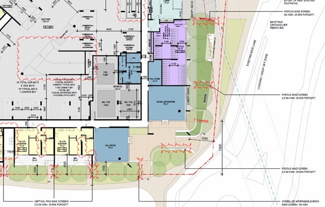
10.45 Further consideration of Crime Prevention Through Environmental Design (CPTED) or Designing out Crime principles need to be incorporated into these structures. Any future proposals for wind screens should treat them as a landscape element and ensure they are integrated with other elements in the landscape.
10.46 Further to this, coordination of site services and wind mitigation to minimise visual and amenity impacts is advised.
Overshadowing and other impacts to the public realm
10.47 A key consideration in the design of the building was overshadowing to public spaces. The most sensitive interface for the proposed development will be the southern interface with the Bay Trail and adjoining areas of public open space. This area is identified within the Strategic Framework Plans at Clause 02.04-5 as being ‘regionally significant open space’.
10.48 The two tower forms of building 1 have been sited, and building heights limited to ensure the overshadowing of the Bay Trail is minimised. The shadow diagrams prepared by Hayball demonstrate some limited overshadowing during this time however this is generally limited to the vegetated area north of the pedestrian/cycling pathway. At all hours during the Winter Solstice, the vast majority of the open space is free of shadow and has decent solar access.
10.49 In particular, the southern part of the Bay Trail owing to its location, is always free from any shadows. It is further identified that the open space area will maintain a high degree of amenity as the overshadowing predominantly impacts the vegetated areas, rather than the grassed areas of public open space.
10.50 It is further noted that these vegetated areas are predominantly dense foliage, so the amenity value of them is limited as the space is less usable. During the September solstice, the proposed buildings do not cast any shadow over the Bay Trail or the adjoining public open spaces.
10.51 This outcome ensures that the amenity of these spaces will not be adversely affected with respect to overshadowing as a result of the proposed development in compliance with the requirements of Clause 52.20-6.12.
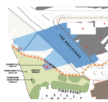
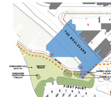
10am Winter Solstice Shadow 12pm Winter Solstice
Flooding Impacts
10.52 Part of the Subject Site is subject to flooding from the Melbourne Water drainage system, whilst the Clause 52.20 (Victoria’s Big Housing Build), does not specifically allow the assessment of the flood overlays, and sea level rise, the applicant has advised the following in their planning submission (see page 34 of the planning report).
10.53 ‘The proposed development has been designed with these flooding considerations in mind, with open space proposed along the relevant overlay areas at the lowest points on the Subject Site’. Initial feedback to the applicant has been provided by Melbourne Water, outlining the following information:
· Flooding Source as the Barak Road Main Drain, which runs throughout the Subject Site.
· A relevant flood level for the 1% AEP (Annual Exceedance Probability) flood level is 2.6 metres to AHD (Australian Height Datum).
· The 2100 1% AEP flood level for the property is 2.4 metres to AHD.
· Key access roads surrounding the Subject Site are all subject to flooding risk.
10.54 Consequently, the finished floor levels of the development have apparently been designed in consultation with Melbourne Water, with the finished floor levels of all habitable areas to be constructed no lower than 300mm above the applicable flood level (which as above, varies across the Subject Site).
10.55 The proposed design (siting and finished floor levels) will ensure that the development will not unreasonably impact floodwaters and appropriately minimises risk from flooding.
10.56 In addition, it is understood the application will be formally referred to Melbourne Water during the consultation process.
Vegetation Removal
10.57 During the site demolition that was undertaken in early 2023, 58 trees were removed on the subject site. A further 18 trees will be removed to accommodate the proposed development. The subject site is not subject to any environmental or landscape overlays pertaining to vegetation removal and therefore no permit requirement is required to remove said vegetation, with the exception of the removal of ‘Native Vegetation’ under Clause 52.20-8 (normally Clause 52.17).
10.58 The applicants state that ‘all native vegetation on site was found to be planted and therefore is exempt from protection under Clause 52.17-7 (Native Vegetation). Therefore, no offsets are required to remove the existing vegetation on site’. However, this evidence has never been provided to Council, therefore the need for retrospective planning approval is considered to still stand.
10.59 There are four trees that remain on the subject site which have been retained due to their moderate (Tree 23) and high (Trees, 63, 64, 67) Arboricultural value. Trees, 23, 63, 64 and 65 will experience minor TPZ encroachments as a result of the proposed development. The remainder of the trees will experience major TPZ encroachment. Arborist supervision will be required when works are to take place in proximity to the trees and its roots and tree protection measures will be required to be installed.
10.60 Aboriginal Cultural Heritage
All of the land is in an 'area of cultural heritage sensitivity' as defined under the Aboriginal Heritage Regulations 2018. This includes registered Aboriginal cultural heritage places and landform types that are generally regarded as more likely to contain Aboriginal cultural heritage.
Under the Aboriginal Heritage Regulations 2018, ‘areas of cultural heritage sensitivity' are one part of a two-part trigger which require a 'cultural heritage management plan' be prepared where a listed 'high impact activity' is proposed.
If a significant land use change is proposed (for example, a subdivision into 3 or more lots), a cultural heritage management plan may be triggered. One or two dwellings, works ancillary to a dwelling, services to a dwelling, alteration of buildings and minor works are examples of works exempt from this requirement.
Under the Aboriginal Heritage Act 2006, where a cultural heritage management plan is required, planning permits, licences and work authorities cannot be issued unless the cultural heritage management plan has been approved for the activity.
As a Cultural Heritage Management Plan or relevant exemption has not been provided a condition will need to be added to any issuing permit that this must be provided prior to works commencing.
11. INTEGRATED DECISION MAKING AND CONCLUSION
11.1 Clause 71.02 of the planning scheme requires the decision maker to integrate the range of policies relevant to the issues to be determined and balance the positive and negative environmental, social, and economic impacts of the proposal in favour of net community benefit and sustainable development. When considering net community benefit, fair and orderly planning is key; the interests of present and future Victorians must be balanced; and the test is one of acceptability.
11.2 The proposal would result in several positive, neutral, and negative impacts which are outlined below:
Positive
· The proposal is considered to have strong strategic support from the planning scheme, which has a consistent theme of increasing the density of affordable residential dwelling at strategic locations and within relatively close proximity to jobs, services and public transport (environmental, economic and social).
· The proposal would include communal open space areas and pedestrian connections that could be utilised by the wider public (with some corrections including to wind mitigation measures).
Neutral
· Internal amenity would be provided commensurate with the approved development, except in the studio apartments.
· The car parking provision for dwellings would be adequate, provided rates for larger dwellings are increased and vehicle swept path issues are resolved.
· The flood impacts are stated to be suitably mitigated, with Melbourne Water confirmation yet to be sighted.
Negative
· The siting and setbacks of the built forms dominate the surrounding streetscapes.
· The extent of landscape removal, and reliance on Council street verges for a landscape buffer is detrimental to the neighbourhood character.
12. OFFICER DIRECT OR INDIRECT INTEREST
12.1 No officers involved in the preparation of this report have any direct or indirect interest in the matter.
13. OPTIONS
13.1 Provide comments to the Minister for Planning c/- Homes Victoria as recommended.
13.2 Provide changed or additional comments to the Minister for Planning c/- Homes Victoria to those recommended.
13.3 Refuse to provide comments.
14. CONCLUSION
14.1 To provide a Council position on an application to the Minister for Planning C/- Home Victoria under Clause 52.20 (Victoria’s Big Housing Build) of the Port Phillip Planning Scheme for 1/16 Barak Road, Port Melbourne (Barak-Beacon Public Housing Estate).
14.2 Under Clause 52.20-2 an application is exempt from the requirement to ‘obtain a permit or any provision of this planning scheme that prohibits the use or development of land, requires the use or development of land to be carried out in a particular manner, or requires a specified thing to be done to the satisfaction of a specified person or body, does not apply to any use or development this clause 52.20 applies to if requirements of clause 52.20 are met’.
14.3 Accordingly, the Minister for Planning is the Responsible Authority for an application that meets the requirements of Clause 52.20-3 of the Port Phillip Planning Scheme, which is the case in this instance.
14.4 It is recommended that the Council resolve that a letter be sent to the Minister for Planning c/- Homes Victoria advising that:
Council does not support the following aspects of the development (as further detailed in this report:
· The front setbacks of Buildings 2 and 3 to Barak Road.
· The rear setbacks of Buildings 2 and 3 to Beacon Road.
· The extent of hard surface and lack of planting opportunities along the eastern elevation of Building 4.
· Lack of integration of the internal pathways to Beach Street (including pedestrian crossing across Beacon Road)
· The low number of three or more bedroom apartments identified as a core housing requirement through the Council area.
· The internal amenity of the studio apartments as outline in Section 10 of this report.
· The lack replacement canopy tree planting, particularly along the east and west boundaries.
· Failure to provide the internal communal open space areas required.
· Further consideration required regarding parking provision, especially for larger dwellings, and regarding vehicle swept path issues in the car park.
· Revision of wind mitigation measures to reduce their visual and amenity impact.
14.5 All other aspects of the proposal including traffic, sustainable design and waste management are generally acceptable subject to receipt of more detailed information which may result in minor changes to the proposal. These design and operational concerns need to be addressed or conditioned in any permit to be issued.
|
ATTACHMENTS |
Meeting of the Port Phillip City Council
6 March 2024
|
Draft Housing Strategy and Phase 3 Community consultation |
|
|
Executive Member: |
Brian Tee, General Manager, City Growth and Development |
|
PREPARED BY: |
Samindi Yapa, Strategic Planner Lingna Zhang, Senior Strategic Planner |
1. PURPOSE
1.1 To outline the key strategies and actions of the Draft Places to Live: Port Phillip Housing Strategy (the Draft Strategy).
1.2 ![]() To seek Council endorsement for releasing the Draft Strategy and
supporting technical report for community consultation.
To seek Council endorsement for releasing the Draft Strategy and
supporting technical report for community consultation.
2. EXECUTIVE Summary
2.1 As more people choose to call Port Phillip home, housing growth will need to change to maintain the city’s liveability, accessibility, and diversity.
2.2 The new Places to Live: Port Phillip Housing Strategy (the Strategy) will help guide and manage housing growth over a 15-year period, providing certainty and consistency of housing outcomes across residential areas of the municipality.
2.3 The Strategy will ensure adequate housing growth can be accommodated in Port Phillip and will provide guidance on the type of new housing required to meet current and future community needs. The Strategy will help to achieve our Community Vision in the Proudly Port Phillip Council Plan 2021-31.
2.4 Officers have prepared the draft Places to Live: Port Phillip Housing Strategy following two rounds of community consultation (see Attachment 1).
2.5 The Draft Strategy demonstrates that there is enough existing residentially zoned land to accommodate projected housing growth in Port Phillip, however some intervention is necessary to influence the type of housing being provided to improve housing outcomes around diversity, design, character, affordability and sustainability.
2.6 The Draft Strategy outlines a vision for Housing in Port Phillip, objectives, strategies and an action plan for implementation. There are two main tools which will be used to implement the actions in the Draft Strategy: planning scheme amendments and advocacy.
2.7 Community consultation on the Draft Strategy is proposed for five weeks in March – April this year (Phase 3 community engagement). Consultation will include in person and online opportunities for the community to provide comments and ask questions. See Section 5 for information on Phase 1 & 2.
2.8 Community feedback from the Phase 3 community engagement will then be considered in preparing the final Strategy for Council endorsement in mid-2024.
|
That Council: 3.1 Endorses the release of Draft Places to Live: City of Port Phillip Housing Strategy (Attachment 1) and supporting documents (Attachment 2, 3 and 4) for community and stakeholder consultation. 3.2 Authorises the Chief Executive Officer, or their delegate to finalise and make minor changes that do not materially alter Draft Places to live: City of Port Phillip Housing Strategy prior to publication for consultation. |
4. KEY POINTS/ISSUES
Rationale for a new Housing Strategy
4.1 State planning policy requires councils to proactively plan for projected population growth over at least a 15-year period and provide clear direction on locations where growth should occur.
4.2 A Housing Strategy is the key foundational strategic planning document that assists Council in planning for our residents' current and future housing needs.
4.3 Council's existing Housing Strategy was finalised over 15 years ago and lapsed in 2017. Since it was adopted in 2007, changes to Port Phillip’s planning framework, have had significant local implications, including:
a) Rezoning the Fishermans Bend Urban Renewal Area (‘Fishermans Bend’) in 2012 to accommodate residential land uses and development. Fishermans Bend will be Australia’s largest urban renewal area. It is anticipated that the Port Phillip portion will accommodate 68,000 residents.
b) Release of Melbourne’s Metropolitan Planning Strategy, Plan Melbourne 2017-50, which outlines how Melbourne will meet the demand for housing diversity and growth, including by accommodating an increased percentage of new housing in established areas and activity centres.
c) Introduction of a new suite of residential zones in 2013 (reformed in 2017), which provided local government with the opportunity to direct the location and scale of residential change.
d) Updated State Government population and household projections.
4.4 An up-to-date Housing Strategy provides direction on where, and how much housing should be accommodated in areas across the municipality. This supports Council in undertaking precinct level structure planning such as the South Melbourne Structure Plan.
Housing Strategy Approach
4.5 A Housing Strategy must be prepared in accordance with State Government requirements, must be evidence-based and provide strategic justification for any proposed changes to the planning scheme.
4.6 The draft Strategy is informed by several technical investigations, including:
· Affordable Housing Needs Study (SGS Economics and Planning) (Attachment 2)
· Neighbourhood Character Study (LAT Studios) (Attachment 3)
· Housing capacity report (Urban Enterprise) (Attachment 4)
4.7 The Housing capacity report is currently being updated to reflect the most recent ABS census and Victorian in Future data released in 2023. The Draft Strategy will be updated post-community consultation to reflect the updated findings. The changes are not anticipated to have any significant impact on the draft Strategy as currently prepared.
4.8 The Draft Strategy has undergone a peer review process to ensure its robustness.
4.9 The Draft Strategy aligns with other projects being undertaken concurrently by Council, including the municipal-wide Spatial Economic and Employment Framework and the draft South Melbourne Structure Plan.
4.10 Council officers prepared a Discussion Paper to help refine the scope, priorities, and direction of the draft Strategy. Community was consulted on the Discussion Paper in April / May 2023 (Phase 2 consultation). The outcomes of that consultation were presented to Councillors in July 2023. More detailed Neighbourhood Character conversations, separate to the project consultation program, took place in July 2023.
4.11 The feedback has resulted in several refinements to key components of the Draft Strategy including the Vision and specific Actions. (A summary of consultation findings is outlined in Sections 4.6 & 4.6 of this report).
4.12 The Strategy will be primarily implemented through an amendment to the Port Phillip Planning Scheme. The planning scheme amendment process generally takes up to 2 years and will need to be approved by the Minister for Planning.
4.13 The Strategy will also have non-statutory implementation directions, which includes advocacy initiatives and projects to assist statutory implementation.
Vision and Objectives of the draft Housing Strategy
4.14 The vision for the draft Housing Strategy is:
A City with liveable places that meet the needs of our diverse and growing community.
An evolving City that respects the rich history while looking to the future. A City of safe, distinct, inclusive, interconnected neighbourhoods. A City that continues its long-standing commitment to providing affordable housing and is a home to our diverse community. A City that is sustainable and resilient to meet the challenges of a changing environment.
4.15 To achieve the vision, the draft Housing Strategy sets out 6 objectives:
· Objective 1: Ensure adequate housing supply.
· Objective 2: Direct new housing to appropriate locations.
· Objective 3: Encourage new housing to respond to preferred neighbourhood character.
· Objective 4: Encourage a range of housing options to support our diverse community.
· Objective 5: Support new housing to be well-designed and resilient to the impacts of climate change.
· Objective 6: Facilitate the provision of more affordable housing.
4.16 Detail on each of these objectives and how they will be achieved is outlined in the Draft Strategy, below is a high-level summary of the draft Objectives and the key recommendations of the Draft Strategy.
Objective 1: Ensure adequate housing supply.
4.17 By 2036, we expect an extra 43,510 people will move to our city and live in an additional 21,480 homes (Victoria in Future population projections, 2023)
4.18 Port Phillip has a strong housing supply pipeline (0 to 5 years) to meet expected short-term demand, and sufficient residential land to accommodate projected housing demand over the next 15 years. Therefore, the Draft Strategy recommends monitoring and reviewing development and trends.
Objective 2: Direct new housing to appropriate locations.
4.19 The location of new housing is critical to creating a sustainable city. Melbourne’s Metropolitan Strategy, Plan Melbourne 2017-2050, is guided by the principle of 20-minute neighbourhoods. Within a local context, Port Phillip seeks to facilitate 10-minute neighbourhoods which requires locating housing and jobs “close to existing (or soon to be completed) high quality pedestrian routes and frequent public transport services that connect to key destinations like schools, employment, shops and community facilities.” (Move, Connect, Live: Integrated Transport Strategy 2018-28).
4.20 In response, the Draft Strategy directs housing growth to areas close to services, jobs, public transport, and areas within and around activity centres and where there is the greatest capacity for change. Housing development will be more limited in established residential areas to protect heritage and neighbourhood character.
4.21 Areas surrounding Major Activity centres, Neighbourhood Activity Centres and train stations (within 800 metres) are flagged for further investigation as key strategic opportunity for new housing, particularly ‘infill’ development. Further strategic work is required to determine the appropriate level of housing growth. This approach acknowledges several key considerations:
· Both Port Phillip’s Major Activity Centres (Bay Street, Clarendon Street, Fitzroy and Acland Streets and Carlisle Street) and Neighbourhood Activity Centres (including Armstrong Street, Middle Park, Ormond Road / Glenhuntly Road, Elwood, Bridport Street/Victoria Avenue, Albert Park) have a role to play in facilitating 10-20 minute neighbourhoods – this is a shift from current policy which focuses only on Major Activity Centres.
· Community feedback from previous consultations has indicated support for increased housing and greater housing diversity near existing infrastructure and services.
· Some of those areas are protected by Heritage Overlays (HO). While the HO does not prohibit development it requires compliance with the council's heritage policy and will impact development outcomes and potential yields. While the HO is often seen as the reason for limiting growth, it is the combination of the residential zone (which restricts building height), HO, and various land constraints - including lot sizes, street width and site access - that shapes outcomes. The draft strategy proposes to investigate whether additional housing capacity may be achieved through upzoning some of this land. This would be further investigated through feasibility testing and further capacity modelling.
4.22 A Residential Development Framework Plan (the Plan) is a spatial plan that identifies areas with different levels of future housing change (minimal, incremental, moderate, substantial). This provides certainty to the community about where growth and intensification will be encouraged.
Residential Development Framework Plan – Draft Change Area Definitions
|
Change Area Type |
Proposed criteria based on Planning Practice Note 90 and applied to Port Phillip local setting |
|
Substantial Change Areas have the capacity to accommodate a high amount of housing growth over time. |
· Major Urban Renewal Area and Precincts e.g. Fishermans Bend Urban Renewal Area (FBURA) and St Kilda Road North (including Domain) · Strategic Sites or Urban Renewal sites identified in a Structure Plan |
|
Moderate Change Areas that have the capacity to accommodate moderate housing growth over time. |
· Mainly within major activity centres and large neighbourhood activity centres (Ormond Road, Elwood) where moderate growth can be accommodated but where new development should respect existing valued neighbourhood character and/or heritage attributes. |
|
Incremental Change Areas that have the capacity to accommodate a modest level of housing growth over time. |
· Within established residential areas where existing neighbourhood character will evolve and change over time with reference to key neighbourhood attributes identified in current local policy and through the Neighbourhood Character Study. · Includes neighbourhood and local activity centres (except Ormond Road, Elwood which is ‘Moderate Change’) · May include heritage areas within proximity to activity centres and train stations (subject to further investigation to determine capacity) |
|
Minimal Change Areas that have limited capacity to accommodate future housing growth over time |
· Within established residential areas that have special and valued neighbourhood, heritage, environmental, or landscape characteristics. |
4.23 The Plan is a key implementation tool that along with the preferred Neighbourhood Character Statements (see objective 3 below) will be translated into local planning policy, residential zones and zone schedules to provide statutory guidance on the level of housing change, typology and built form / character outcomes desired.
4.24 Many areas in the municipality are vulnerable to the impacts of climate change and at risk of increased flooding and extreme weather events:
· Special Building Overlays exist in many parts of Port Phillip, which trigger a referral to Melbourne Water to ensure development is undertaken with flood risk considered and often results in the need to construct new development to an elevated finished floor level.
· Melbourne Water has provided Council officers with updated interim flood data and modelling / mapping which includes updated sea level rise information. Officers have been using this information as the ‘best available’ to inform the Housing Strategy.
· Work is also underway to understand the ‘flood sensitivity’ of the housing capacity based on the SBO and Melbourne Water’s flood mapping.
· In January 2024, the Department of Energy, Environment and Climate Action (DEECA) released new Coastal Hazard Vulnerability Data. Until Melbourne Water and Council officers have comprehensively reviewed the DEECA data, officers will continue to rely on the interim Melbourne Water Sea level rise data and mapping as the ‘best available’.
· Port Phillip will continue to work with Melbourne Water and DEECA to ensure the most up to date, best-available information is used to inform housing development.
Objective 3: Encourage new housing to respond to preferred neighbourhood character.
4.25 When planning for future housing growth, it is important to identify valued existing neighbourhood character elements, where it exists, and preferred future character to guide new development. The Neighbourhood Character Study focuses on established residential areas where no specific built form or heritage controls apply. This study area is predominately in the south of CoPP (Elwood and Ripponlea, Balaclava and St Kilda East, St Kilda and St Kilda West), and Port Melbourne, parts of Middle Park, Albert Park and South Melbourne.
4.26 The Study identified five key ‘Character Areas’ and has prepared Preferred Future Neighbourhood Character Statements which aim to reflect the valued features and characteristics of an area but also be ‘forward-looking’ to ensure contemporary housing needs are being met.
4.27 The development of the Preferred Future Neighbourhood Character Statements was informed by ‘Neighbourhood Character Conversations’ held with community in July 2023. These statements will inform new design objectives, standards and requirements to be incorporated into the Planning Scheme through changes to the schedules in the residential zones applying to the character areas.
4.28 This document is in the final stages of development and will be finalised for presentation to Council at a meeting in March 2024 to consider Phase 3 engagement with the community.
Objective 4: Encourage a range of housing options to support our diverse community.
4.29 While there is currently a sufficient supply of housing being delivered, there is a lack of diversity in terms of bedroom mix and dwelling typology being delivered. For example, the majority (67 per cent) of dwellings in our city have two or less bedrooms. 56 per cent of dwellings in our city are high density apartments (above 3 storeys), while less than 8 per cent of dwellings in our city are separate houses. As such, the Draft Strategy recommends strengthening local planning policy to include minimum bedroom ratios for new developments of 100 dwellings or more. As local planning policy cannot impose the ratio as a mandatory diversity requirement, the final diversity ratio will predominantly be influenced by market dynamics. Instead, the Draft Strategy articulates the objectives that the policy aims to achieve and provides Council’s statutory planners with strategic guidelines when assessing development applications and a policy position to enter negotiations with developers.
4.30 Consistent with Australia-wide trends, our population is ageing. Ageing in place in secure housing, or other accommodation, is fundamental for health and wellbeing. The Draft Strategy encourages new residential development to incorporate design features that provide accessibility to people of all ability. This will be implemented through the development of design guidelines. The Draft Strategy also supports the delivery of diverse aged care models in areas close to services, public transport and activity centres.
Objective 5: Support new housing to be well-designed and resilient to the impacts of climate change.
4.31 The lack of land available in Port Phillip for development of new separate houses means that apartments will continue to be the predominant housing typology for new housing. Therefore, it is important that they are well-designed, liveable and provide a level of internal and external amenity to improve the occupant’s health, wellbeing, and overall quality of life. The Draft Strategy recommends advocating to the State Government to update the Apartment Design Guidelines Victoria to address specific gaps to achieve amenity and liveability in new apartment development.
4.32 The current suite of Environmentally Sustainable Development (ESD) requirements in the Port Phillip Planning Scheme are not adequate to tackle climate change. Port Phillip is working with the Council Alliance for a Sustainable Built Environment (CASBE) and 23 other councils to introduce new planning policy that elevates ESD in new development and encourages a move towards net zero carbon development. Council is also updating the Sustainable Design Strategy during 2024-25, which will help set new standards for building design in City of Port Phillip. To support this the draft Housing Strategy recommends continued advocacy to the State Government to authorise the preparation of the Elevating ESD Targets Planning Scheme amendment.
Objective 6: Facilitate the provision of more affordable housing.
4.33 Affordable housing is essential infrastructure for sustainable, inclusive, and productive communities.
4.34 The In Our Backyard – Growing Affordable Housing In Port Phillip 2015-2025 (IOBY) Strategy represents Council’s overall vision in Affordable Housing. The Housing Strategy will help implement the In Our Backyard Strategy through recommending use of appropriate planning tools to facilitate affordable housing.
4.35 A proposed key action of the Draft Strategy is introducing a new affordable housing local planning policy which proposes that 10 per cent of new dwellings in future major developments (except in Fishermans Bend) should be affordable housing.
4.36 The proposed affordable housing target of 10% for major developments (20 or more dwellings):
a) Aligns with Housing Assistance Need: 10 per cent of all households in Port Phillip are in severe or moderate rental housing stress.
b) Aligns with Victoria Housing Statement: At least 10 per cent Affordable Housing is encouraged in significant residential developments that utilise the Victorian Government‘s development facilitation program & surplus public land development.
c) Progressive increase of social housing stock: 6.5 per cent of the housing stock in Port Phillip is classified as social (public and community) housing. In 2015, the same figure was 7.2 per cent. The proposed 10 per cent target aims to maintain the current proportion of social housing stock and to gradually increase the proportion of affordable housing units in Port Phillip over time.
d) Alignment with existing targets in Structure Plans: both the Bay Street Activity Centre Structure Plan and Carlisle Street Activity Centre Structure Plan propose a 10 per cent target.
e) Consistency within the range of housing targets proposed in recent strategies by other Councils. (e.g., Yarra, Maribyrnong, Merri-bek)
f) Is not a mandatory requirement. Local government cannot impose mandatory affordable housing targets under the state policy framework. Affordable housing (under most circumstances) can only be facilitated through voluntary agreement, as part of the planning permit application process. A practice guideline could be developed to assist planners and developers in the planning assessment and negotiation process.
g) The actual contribution would be determined case-by-case. Factors to be considered include development feasibility, available government subsidies etc.
h) Developers would enter into a voluntary agreement with Council to provide affordable housing (a ‘s173 agreement’). This is the approach in Fishermans Bend.
Why propose a development threshold of 20 or more dwellings?
4.37 This approach is preferred as it:
a) Exempts small-scale / ‘mum & dad’ developers.
b) Captures a high proportion (89%) of potential new dwellings.
What can Council do to incentivise developers?
4.38 The implementation of the Housing Strategy would explore incentives for developers, such as the fast tracking of planning permits.
4.39 Developers are encouraged to partner with registered housing providers to ensure affordable housing is appropriately provided and managed.
5. Consultation and stakeholders
5.1 Development of the Strategy includes engagement with the community and key stakeholders, such as residents, traders and business owners, community groups, government agencies, and property owners.
5.2 Feedback has been / will be sought key milestones of the project:
|
|
Purpose |
Timing |
|
Phase 1 |
High level engagement to introduce the project to the community and understand their values and concerns related to housing |
September – October 2022 (completed) |
|
Phase 2 |
Consultation on the Discussion Paper |
April – May 2023 (completed) |
|
Phase 3 |
Consultation on the Draft Strategy |
March – April 2024 |
Approach to community consultation
5.3 The overall objectives for the broader project consultation program are as follows:
a) Introduce the project and its purpose, building community knowledge and ensuring meaningful engagement.
b) Inform the community about the project's necessity and the role of local government in housing.
c) Clarify the program's scope and establish a comprehensive engagement process.
d) Understand community concerns, priorities, and aspirations.
e) Provide comprehensive feedback to the community on key findings, demonstrating how their input has influenced the project.
Phase 1 & 2 Community Consultation
5.4 Phase 1 community consultation was undertaken over six weeks, in September – October 2022. The key findings from Phase 1 were:
a) Our community most value housing that is well-designed, energy efficient and affordable.
b) Trees and landscaping within front gardens were identified as neighbourhood character elements most important to Port Phillip residents.
c) Most people believed new housing should be located close to public transport, parks, and open space and local shops.
d) The community indicated that they would like more affordable and social housing, followed by increased protection of neighbourhood character and more focus on green / open space.
5.5 Phase 2 community consultation was undertaken over a four-week period in April – May 2023. The key findings from Phase 2 were:
a) Housing design quality was identified as the most significant housing need, followed by preferred neighbourhood character.
b) Expectation that Council will play a proactive role through the planning process and delivery of affordable housing.
c) The need for diverse, accessible, well-designed housing close to infrastructure and amenities was highlighted.
d) The future of housing that emerged involves accommodating diverse housing needs in a way that preserves neighbourhood character and makes homes more affordable.
Phase 3 Community Consultation
5.6 The third and final phase of community consultation is due to take place during March - April 2024, over a five-week period.
5.7 The primary purpose of Phase 3 is to test the Draft Strategy with the community to assess the level of support. The key objectives are to:
a) Demonstrate how the feedback from Phase 2 informed the development of the Draft Strategy.
b) Test the level of support for the Draft Strategy and identify any areas of concern.
c) Test the level of support for the Residential Development Framework Plan and future neighbourhood character statements.
5.8 The proposed consultation program will consist of:
a) A survey and other engagement activities on Council’s Have Your Say online engagement platform. Hardcopy surveys will also be available.
b) Online information session to provide interested community members and stakeholders with the opportunity to have their questions answered.
c) Online forums to explore elements of the Draft Strategy in more depth with priority stakeholders and build an understanding of Council’s roles and ability to influence housing outcomes.
6. LEGAL AND RISK IMPLICATIONS
6.1 Preparation of the Housing Strategy accords with Council’s obligations under the Planning and Environment Act 1987
6.2 State Government’s update to Plan Melbourne 2017-2050 is due to be released imminently. The new plan for Victoria is set to establish housing targets for local government areas, which may have implications for the provision of housing in Port Phillip. To mitigate this risk officers will work closely with DTP.
7. FINANCIAL IMPACT
7.1 Development of the Strategy was budgeted over 3 years, from FY2022/23 to FY2024/25. The development of the Draft Strategy and Phase 3 community engagement are included in the project budget for the FY2023/24.
7.2 Implementation of the Housing Strategy will be via a planning scheme amendment. This is a separate process which will be subject to a future budget bid through the planning scheme amendments program.
7.3 Implementation of specific Actions of the Housing Strategy will be subject to future budget bids.
8. ENVIRONMENTAL IMPACT
8.1 The Strategy will aim to ensure that new housing will be able to cope with our future environment. The Strategy will aim to ensure housing is energy efficient, climate resilient and located to encourage sustainable and active modes of travel.
9. COMMUNITY IMPACT
9.1 The Strategy is being prepared to ensure the current and emerging housing needs of Port Phillip’s community will be met over the next 15 years.
9.2 The Strategy will provide a robust strategic framework for the management of housing growth and change in the municipality, thereby providing greater certainty and consistency for all participants in the planning process.
9.3 The Strategy is being developed with extensive input from the community.
9.4 Implementation of the Strategy via a Planning Scheme Amendment will have a direct impact on landowners of property that may be used for residential purposes. The degree of this impact will vary pending the housing outcomes desired for each site, and whether it is a change from the current planning provisions.
10. ALIGNMENT TO COUNCIL PLAN AND COUNCIL POLICY
10.1 The Port Phillip Housing Strategy will contribute to achieving all strategic directions of the Council Plan 2021-31. Specifically, the preparation of a new Housing Strategy is a key initiative of Strategic Direction 2: Liveable Port Phillip.
10.2 The Strategy will also help achieve outcomes and key actions of Council’s core strategies; Act and Adapt: Sustainable Environment Strategy 2018-28; Move, Connect, Live: Integrated Transport Strategy 2018-28; and Places for People: Public Space Strategy 2022-32.
11. IMPLEMENTATION STRATEGY
11.1 TIMELINE
11.1.1 Phase 3 community and stakeholder consultation on the Draft Strategy will occur in March this year.
11.1.2 The final Strategy (including the Residential Development Framework Plan) and findings from Phase 3 community engagement will be presented to Council for consideration and subsequent adoption in mid-2024.
11.1.3 The draft Housing Strategy contains an implementation program which lists the actions and provides a timeframe for delivery.
11.2 COMMUNICATION
11.2.1 Stakeholders who have taken part in previous phase of consultation will be directly notified about the consultation, currently proposed for March - April 2024. The wider Port Phillip community will be notified about the consultation period primarily via social media promotions. This will direct people to the project Have Your Say page. Hard copies of the Draft Housing Strategy will be available.
11.2.2 The consultation program will include a range of in person and online opportunities for the community to provide comments, feedback and ask questions.
11.2.3 Phase 3 consultation will provide an opportunity for the community and stakeholders to comment on the content and actions contained in the draft Housing Strategy following on from previous engagement that has led to the development of the draft Strategy.
12. OFFICER DIRECT OR INDIRECT INTEREST
12.1 No officers involved in the preparation of this report have any material or general interest in the matter.
|
ATTACHMENTS |
1. CoPP Draft Housing Strategy 2. CoPP Affordable Housing Needs Study |
Meeting of the Port Phillip City Council
6 March 2024
|
City of Port Phillip Spatial Economic and Employment Framework (SEEF) :Adoption |
|
|
Executive Member: |
Brian Tee, General Manager, City Growth and Development |
|
PREPARED BY: |
Alayna Chapman, Head of City Strategy |
1. PURPOSE
1.1 The purpose of this report is to:
a) Inform Council of the outcomes of the final phase of community engagement on the draft City of Port Phillip Spatial Economic and Employment Framework (SEEF) and the associated technical report titled, City of Port Phillip Spatial Economic and Employment Framework Technical Report December 2023, Urban Enterprise Pty. Ltd. (technical report).
b) Outline the vision, objectives, strategic directions, and actions of the final SEEF for Council’s consideration.
c) Seek adoption of the final SEEF and technical report.
2. EXECUTIVE Summary
2.1 The City of Port Phillip is home to a substantial business and employment base that capitalises on its proximity to the CBD and Port Phillip Bay. While the city’s iconic shopping strips (also known as activity centres) contribute to the city's unique character, there's been a significant shift in the economic and employment landscape.
2.2 The City of Port Phillip’s economic and employment role has evolved from early industrial and seaside resort functions toward professional services and the specialisations of tourism and creative industries. This evolution responds to broader economic trends and local conditions, prompting regular updates to economic and land-use policies.
2.3 Council plays a role in fostering business and employment by creating a conducive environment for economic activity. Land use planning is a key tool, shaping employment and economic activity through policies and controls that influence permissible land uses.
2.4 The SEEF project aims to understand and capitalise on economic and employment growth opportunities in the City of Port Phillip, providing a strategic foundation for future decisions on employment land.
2.5 The final SEEF (refer to Attachment 1) applies to all employment land within the municipality and is informed by stakeholder engagement and a technical report, prepared by Urban Enterprise Pty. Ltd. on behalf of Council (refer to Attachment 2). The SEEF’s ideas have been refined through testing and development, incorporating research findings and stakeholder input.
2.6 The final SEEF outlines a vision, objectives, strategic directions, and actions. Key support mechanisms for these actions include a planning scheme amendment, active monitoring of land use trends and data and fostering collaborative partnerships and advocacy efforts.
|
That Council: 3.1 Notes the officer report in relation to the adoption of a long-term spatial framework for facilitating economic and employment growth in Port Phillip. 3.2 Notes the consultation approach in the preparation of the final City of Port Phillip Spatial Economic and Employment Framework and final City of Port Phillip Spatial Economic and Employment Framework Technical Report December 2023 at Attachments 1 and 2, respectively. 3.3 Adopts the final City of Port Phillip Spatial Economic and Employment Framework at Attachment 1 and the final City of Port Phillip Spatial Economic and Employment Framework Technical Report December 2023 at Attachment 2 as the strategic justification and basis for: a) future decisions on employment land and economic matters; and b) a future amendment to the Port Phillip Planning Scheme to introduce new and amended planning provisions. 3.4 Authorises the Chief Executive Officer (or their delegate) to make any minor editorial changes to the final City of Port Phillip Spatial Economic and Employment Framework at Attachment 1 prior to publication and before applying to the Minister for Planning for authorisation to prepare an Amendment, under section 8A of the Planning and Environment Act 1987. |
4. KEY POINTS/ISSUES
Rationale for a new spatial and economic plan for the city
4.1 Over the last decade the City of Port Phillip's planning framework has undergone significant changes, affecting the local economy and employment:
a) In 2012, The Fishermans Bend Urban Renewal Area (FBURA) was rezoned to accommodate 80,000 residents and 80,000 jobs – 34,000 of which are proposed to be in the City of Port Phillip.
b) The State Government reformed Victoria’s land use zones in 2013, resulting in most of the City of Port Phillip’s business zones defaulting to the more flexible Commercial 1 Zone, which allows for a broader range of uses, including residential. The aim was to facilitate diverse mixed-use precincts and activity centres.
c) The metropolitan planning strategy, known as Plan Melbourne 2017-50 (Plan Melbourne), was released, establishing a hierarchy of employment precincts. This plan also proposes an expanded central city and encourages the creation of 20-minute neighbourhoods.
d) The Melbourne Industrial and Commercial Land Use Plan (MICLUP) was released in 2020, outlining a recommended planning framework for employment land across Melbourne. This plan categorises commercial and industrial areas based on their significance at the state, regional, or local level.
4.2 In 2018, an audit of the Port Phillip Planning Scheme highlighted the need for strategic work to understand how employment land contributes to the local economy. It also emphasised the importance of balancing the city's role as an employment destination with its obligation to accommodate housing growth.
4.3 To guide updated local land use planning policies, the 2018 planning scheme audit suggested that Council create an employment land strategy to better address the city's employment needs and trends, considering a more proactive approach to retaining employment land.
SEEF approach
4.4 The primary goals of the SEEF are to:
a) Understand and realise Port Phillip’s economic and employment growth opportunities.
b) Provide a sound strategic basis for future decisions on employment land.
c) Provide direction for employment outcomes in activity centres.
d) Provide a strategic basis to update planning provisions in the Port Phillip Planning Scheme.
4.5 The development of the SEEF included economic research and analysis, considering the planning policy framework, strategic context, and economic and employment trends. It also calculated employment projections alongside an assessment of development capacity across zones capable for accommodating employment activity.
4.6 The document provides a summary of the main findings and strategic framework outlined in the accompanying technical report. For more in-depth research and analysis, refer to the technical report at Attachment 2. Stakeholder consultation findings are incorporated into both the SEEF and the accompanying technical report.
SEEF findings
Key trends
4.7 Key trends shaping economic and employment dynamics in Port Phillip include:
a) A post-pandemic shift in the commercial property market, with businesses embracing coworking spaces, flexible setups, and remote work technology.
b) Growing competition between residential and non-residential development due to flexible land use zones, leading to a decline in office use in commercial and mixed-use zones.
c) The westward expansion of the central city into the City of Port Phillip, aligning with the city's shift to a service and knowledge-based economy, creating opportunities for Port Melbourne and South Melbourne.
d) The city fringe, particularly South Melbourne and Port Melbourne, emerging as attractive alternative office locations for businesses.
e) Investments in public transport, highlighted by the Anzac Station (Melbourne Metro Tunnel project), as well as developments in health and education precincts (such as the Alfred Hospital) and Melbourne's Arts Precinct.
f) Catalyst developments in the Fishermans Bend National Employment and Innovation Cluster (FBNEIC), including a full-line Woolworths store, a proposed University of Melbourne engineering and design campus, and the revitalisation of the General Motors Holden site.
g) Economic opportunities associated with the city's waterfront assets and precincts, including Station Pier, St Kilda Triangle, foreshore, and St Kilda Marina.
h) Despite having over 400 hectares of land promoting business and economic activity, less than 24 hectares are exclusively reserved for employment purposes, posing a risk of displacing current employment space with residential land use over time.
Key economic data
4.8 The following data provides a snapshot of Port Phillip’s existing and emerging economy.
Current economic data:
a) There are approximately 68,000 employed residents in Port Phillip.
b) There are around 88,000 jobs that exist in Port Phillip.
c) Port Phillip's economic output (Gross Regional Product) is $13.82 billion, making up 2.8% of Victoria's total (Gross State Product). Professional services contribute significantly, accounting for 22%, which is almost twice the Victorian average of 11%.
d) There are approximately 21,000 businesses registered in Port Phillip, most of which are non-employing businesses (62% or 13,000).
e) Employment in the City of Port Phillip is primarily concentrated in the northern section of the municipality, including St Kilda Road North, South Melbourne, and Fishermans Bend.
f) The greatest industry of employment is professional, scientific, and technical services, which accounted for 20% of all jobs, followed by health care and social assistance, construction, retail trade and accommodation and food services.
g) There is an estimated additional employment land capacity of 1.71 million sqm (excluding Fishermans Bend).
2041 forecasted data:
a) Employment in Port Phillip is projected to increase to between 22,000 and 43,000 jobs over the period to 2041, equating to average growth rates of 1.2% - 2.1% per annum.
b) Most job growth is projected in professional, scientific, and technical services, education, and health care.
c) The greatest increases in employment are expected to occur in the northern part of the municipality including South Melbourne, St Kilda Road, and Fishermans Bend, while St Kilda is also projected to experience significant employment growth.
d) There is projected to be an overall need for an additional 562,000sqm of employment floorspace over the SEEF period (excluding Fishermans Bend), for which the City of Port Phillip has the employment land capacity to accommodate.
SEEF recommendations
4.9 The vision for the City of Port Phillip’s employment land has been developed to facilitate economic prosperity at the local and state levels and support the delivery of the community vision. Please refer to page 39 of Attachment 1 for the full vision.
4.10 The objectives of Council to achieve the vision are as follows:
Objective 1. Accommodate demand for employment growth in locations of advantage due to existing agglomeration, infrastructure, and place characteristics.
Objective 2. Strategically and proactively manage transition of former industrial areas – particularly Fishermans Bend – to ensure that economic opportunities are maximised and consider local specialisations and opportunities.
Objective 3. Ensure that residential land use complements rather than displaces economic activity and employment.
Objective 4. Support the recovery, resilience, and growth of specialised sectors with links to cultural identity, innovation and specialisation, especially cultural and creative activities and events and hospitality.
Objective 5. Provide a land use and built form environment which attracts and retains a talented professional workforce.
Objective 6. Promote opportunities for business and employment growth aligned with health and education institutions and related innovation.
Objective 7. Promote the availability of a range of retail, service and employment types in activity centres and villages.
4.11 Five Strategic Directions (SD) have also been developed to achieve the vision and objectives as follows:
SD1. Accommodate and optimise an expanded Central City: Employment land in the northern parts of the City of Port Philip (St Kilda Road North and Fishermans Bend) is identified in policy as areas of state significance which form part of Melbourne’s ‘central city’. Planning for intensification of employment and business activity in these areas will generate economic benefit and cluster knowledge-based businesses (high and medium-high-technology manufactures, together with health and education services, financial and business services, and communication services).
SD2. Support and grow areas of specialisation, innovation, and competitive advantage: This direction seeks to foster growth in areas that demonstrate specialisation, innovation, and competitive advantages. It aims to leverage the unique strengths of different regions within the municipality. Key regionally significant locations where employment land should be retained and complemented by supporting uses include:
i) South Melbourne Enterprise Precinct - for ongoing commercial, creative and media activity.
ii) St Kilda’s concentration of cultural venues, creative activity, and the night-time economy.
iii) Alfred Hospital is a highly specialised medical institution which can be supported by accommodating uses that directly and indirectly support the function of a broader health precinct.
iv) Visitor gateways and destinations including Station Pier, St Kilda Marina and the St Kilda Triangle present the opportunity to grow regional and global tourism and generate local employment.
SD3. Strengthen and diversify Activity Centre and neighbourhood economies: This direction seeks to enhance the economic resilience and diversity of local centres and neighbourhoods. This involves supporting essential services, goods, and hospitality businesses, with a focus on resilience and diversification in the face of economic challenges.
SD4. Retain local employment precincts and increase utilisation: This direction seeks to revitalise and intensify the economic use of local mixed-use and employment precincts. It recognises the importance of retaining employment land and encourages greater utilisation, especially in areas where new employment land opportunities are limited.
SD5. Align housing, transport, and employment policy: This direction seeks to ensure a cohesive approach to land use, built form, and transport planning. It emphasises the need to align housing, transport, and employment policies to create a well-integrated strategy, considering factors such as housing availability, affordability, and their impact on the local economy.
4.12 Each direction addresses specific aspects of economic and employment development within the City of Port Phillip, contributing to an overall framework for sustainable growth and prosperity.
4.13 Figure 1. shows a spatial framework which identifies the recommended roles of employment precincts and activity centres over the planning period.
Figure 1.Spatial framework
SEEF Implementation
4.14 Each direction has specific actions. These actions, with the strategic directions, provide a comprehensive strategy to guide the City of Port Phillip in achieving its economic and employment vision and objectives. The SEEF emphasises coordination across various sectors, including housing, transport, and land use, to create a cohesive and sustainable approach to economic development. It aims to align and support other adopted Council strategies that guide decisions and investment across the municipality.
4.15 Following Council adoption, the SEEF actions would be implemented through a mix of methods, including a planning scheme amendment, ongoing monitoring of land use trends and data, and the cultivation of collaborative partnerships and advocacy efforts.
5. CONSULTATION AND STAKEHOLDERS
5.1 Preparing the final SEEF and technical report has included two phases of engagement with the community (refer to Table 1), including key stakeholders such as residents, traders and business owners, community groups and property owners.
|
Phase |
Purpose |
Timing |
|
Phase 1 |
Initial targeted consultation to uncover emerging challenges and opportunities in preparation for drafting the SEEF and technical report. |
Sep 2022 |
|
Phase 2 |
Broader consultation on the draft vision, objectives, and strategic directions of the draft SEEF and supporting draft technical report. |
Jun-Aug 2023 |
Table 2. Engagement phases
Phase 1 community engagement
5.2 In September 2022, Phase 1 community engagement involved economic research, targeted consultations with businesses, representatives, and the Council’s Business Advisory Committee. This phase aimed to introduce the project to stakeholders, improve our understanding of community perceptions and priorities for Port Phillip’s economy. Methods included business surveys, workshops, focus groups, and interviews. Findings were incorporated into the draft SEEF, endorsed on 3 May 2022, for public engagement.
Phase 2 Community Engagement:
5.3 Phase 2, from June to August 2023, sought feedback on the draft SEEF vision, objectives, and directions. Activities were promoted on social media and Council’s 'Have Your Say' website. Building on Phase 1, over 500 visits to the website were recorded. Feedback from various activities, including online surveys, newsletters, and focus groups, shaped the final SEEF. Key findings addressed language clarity, the relationship between residential and economic land use, Fishermans Bend planning, public transport, and talent attraction.
Feedback impact:
5.4 Feedback from Phase 2 led to updates in the final SEEF (Attachment 1) and technical report (Attachment 2), providing a more comprehensive overview of the economic landscape in Port Phillip. These updates aimed to better quantify the impact of the COVID-19 pandemic on future economic growth patterns, simplify language and offer a clearer perspective on the current and future economic outlook for Port Phillip.
5.5 Community engagement, coupled with updates to analysis and projections to capture the results of the 2021 Census and Victoria in Future 2023 (the official State government projection of population and households) has contributed to a more current, refined, and responsive final SEEF and technical report.
5.6 A detailed summary of the feedback received is included in the engagement report available on Council’s 'Have Your Say' website: Supporting Economic and Employment Growth in our City | Have Your Say Port Phillip.
6. LEGAL AND RISK IMPLICATIONS
6.1 Preparation of the SEEF accords with Council’s obligations under the Planning and Environment Act 1987.
7. FINANCIAL IMPACT
7.1 There are no direct financial implications for Council to consider from the adoption of the final SEEF.
8. ENVIRONMENTAL IMPACT
8.1 The final SEEF has a vision which seeks to have local employment land that will meet the needs of residents and provide opportunities for employment close to home, responding to the need for sustainable, resilient, and liveable communities.
9. COMMUNITY IMPACT
9.1 Phase 1 and 2 engagements provided the opportunity for the community to share their thoughts on the vision, objectives and a series of directions and strategies which support economic growth and vitality over the coming years.
10. ALIGNMENT TO COUNCIL PLAN AND COUNCIL POLICY
10.1 The final SEEF is informed by Council’s policies and strategies and will contribute to achieving the strategic directions outlines in the current Council Plan 2021-31.
11. IMPLEMENTATION STRATEGY
11.1 The final SEEF and technical report (refer to Attachment 1 and Attachment 2, respectively) applies to all employment land within the municipality and establishes a comprehensive 20-year framework for facilitating economic and employment growth in Port Phillip.
11.2 The final SEEF provides a vision, objectives, strategic directions, actions, and a spatial framework plan, to inform future decision making by the city on the evolution, growth, and development of employment land within the municipality. The SEEF’s implementation will include active monitoring of land use trends and data and fostering collaborative partnerships and advocacy efforts. Notably, the primary implementation of the SEEF will occur via a future planning scheme amendment.
Future Planning Scheme Amendment
11.3 Following adoption by Council, the final SEEF and technical report will provide the strategic basis for an amendment to the Port Phillip Planning Scheme. The amendment would seek to introduce new and amended economic and employment planning provisions to reflect the key strategic directions outlined in the documents. The amendment would also include the SEEF and technical report as background documents in the scheme.
11.4 There is an opportunity to pursue an Amendment that combines the implementation of the SEEF and the updated Housing Strategy so that employment land policy aligns with housing.
12. OFFICER DIRECT OR INDIRECT INTEREST
12.1 No officers involved in the preparation of this report have any material or general interest in the matter.
|
ATTACHMENTS |
1. City of Port Phillip Spatial Economic and Employment
Framework (March 2024) 2. City of Port Phillip Spatial Economic and Employment
Framework - Technical Report (December 2023) |
Meeting of the Port Phillip City Council
6 March 2024
11. Sustainable Port Phillip
Nil
12. Vibrant Port Phillip
Nil
13. Well Governed Port Phillip
13.1 City of Port Phillip Advocacy Strategy............ 119
13.2 Municipal Association of Victoria State Council - May 2024 - Submissions................................. 123
13.3 Proposed Discontinuance of Road Adjoining 3-5, 7, 9, and 15 Fitzroy Street, St Kilda................ 129
13.4 Audit and Risk Committee - Biannual Report as at 31 December 2023 AND Annual Review of the Committee Charter.......................................... 137
13.5 Status of Council Decisions and Questions Taken on Notice recorded by Council: 1 October - 31 December 2023........................................ 141
Meeting of the Port Phillip City Council
6 March 2024
|
City of Port Phillip Advocacy Strategy |
|
|
Executive Member: |
Brian Tee, General Manager, City Growth and Development |
|
PREPARED BY: |
Chris Brayne, Coordinator Advocacy, Grants & Partnership James Gullan, Head of Advocacy, Economic Development and Partnerships |
1. PURPOSE
1.1 To seek Councillor endorsement of the new City of Port Phillip Advocacy Strategy 2024-2027
2. EXECUTIVE Summary
2.1 Advocacy is an important tool used by councils to raise awareness of, and champion issues that are within their control, as well as outside their control. Effective advocacy is done by seizing any opportunity to promote Council’s key messages and inform government of these priorities.
2.2 Council is at the heart of their communities, therefore are best placed to respond to their needs and advocate for priorities that are important to its people and places. This means taking action to influence or partner with other levels of government, agencies, decisions makers and key stakeholders to deliver funding, projects, services or policy change that will benefit the local community.
2.3 Council does not currently have a formal advocacy strategy to guide and support Council’s key initiatives and Council Plan objectives. This has resulted in an advocacy program that lacks clear processes and is often reliant on the personal connections and networks of advocacy officers and Councillors. This could potentially impact on operational continuity for Council business and can provide inconsistent outcomes.
2.4 This Advocacy Strategy will provide clarity on the work of the advocacy team and ensure Council is maximising opportunities for future success through appropriate resourcing and relationship management.
|
That Council: 3.1 Endorses the City of Port Phillip Advocacy Strategy 2024-2027 to provide Councillors, officers and the community with an advocacy process that details how Council prioritise, implement, and report on advocacy priorities. 3.2 Authorises the Chief Executive Officer, or their delegate to make any minor amendments that do not change the material intent of the Strategy. |
4. KEY POINTS/ISSUES
4.1 City of Port Phillip undertakes advocacy on behalf of residents and community for outcomes beyond the scope of local government.
4.2 Effective advocacy requires Council to have a clear understanding of the issues and challenges facing their community, and objectives on how to address and solve such challenges or opportunities.
4.3 Advocacy has increased funding for the delivery of Council programs, services and projects that benefit the Port Phillip community and to influence government legislation, policy or practices.
4.4 Advocacy is the key mechanism that Council uses to influence government decision makers.
4.5 At the 2022 Federal and State Elections, Council provided local candidates with publicly available advocacy priorities requiring government consideration and/or funding support. Although successful candidates made some funded election commitments, there is opportunity to further expand on council’s public-facing advocacy processes.
4.6 This strategy will provide councillors, officers, and the community with an advocacy process that details how Council prioritise, implement, and report on advocacy priorities.
4.7 Advocacy is resource and time intensive. It is important that this resourcing is provided to Council items that have met minimum threshold requirements. Considerations for prioritisation include initiatives endorsed by Council, the urgency of the initiative or the volume of the community affected.
4.8 This strategy will create a methodology for prioritising Council items and match this level of prioritisation with appropriate levels of resourcing. This is reflected in the Strategy through ‘Gold’, ‘Silver’ and ‘Bronze’ prioritisation levels.
4.9 Developing a key list of ‘Gold’ and ‘Silver’ tiered priorities will ensure that the Council is maximising its efforts in the lead up to critical events for advocacy, such as State and Federal Budgets and Elections.
4.10 Through the updated model set out in the Advocacy Strategy, council can also adopt a more strategic and planned approach that better utilises our stakeholder and advocacy networks.
4.11 The Strategy will further promote transparency and accountability surrounding Council’s advocacy.
5. CONSULTATION AND STAKEHOLDERS
5.1 Councils advocacy priorities are informed by a range of inputs, including the council plan, council budget, community feedback and other key stakeholders.
5.2 Research conducted by the advocacy team included the analysis of existing advocacy strategies by other local government areas.
6. LEGAL AND RISK IMPLICATIONS
6.1 The Advocacy Strategy contains timeframes and actions for the advocacy team. As with any goals or actions, there is a risk that Council will not meet these goals and actions in the planned timeframe.
6.2 Ongoing monitoring of our progress on advocacy items and the impact of the Strategy and the prioritisation methodology will be conducted regularly.
7. FINANCIAL IMPACT
7.1 The Strategy will be delivered within existing budget allocations. If additional funds are required, these will be put to Council for consideration as part of the annual budget process throughout the life of the Strategy.
7.2 The Advocacy Strategy will guide the work of the advocacy team to achieve funding and policy success as we reach the critical events such as the bidding process/delivery of the State/Federal Budgets, and the competitive period preceding the State/Federal Elections, as well as the ongoing day-to-day efforts of the team.
8. ENVIRONMENTAL IMPACT
8.1 Environmental issues such as action on climate change, waste reduction efforts and renewable energy investment represent areas of advocacy for the City of Port Phillip.
8.2 As specified advocacy requests from the Sustainability Team are made, these will be assessed through the Advocacy Strategy’s structured prioritisation process, to determine the level of priority and resourcing allocated to these advocacy items.
9. COMMUNITY IMPACT
9.1 The Advocacy Strategy will create a transparent and measurable advocacy program for our community with clear processes that maximise use of available resources and networks. The Advocacy Strategy deepens the understanding of the advocacy context and asks for specific outcomes and interventions, creating a path for these actions.
9.2 The community is positively impacted by successful advocacy outcomes.
9.3 The Advocacy Strategy provides the opportunity to support existing Council projects and initiatives that benefit community such as Great Places and Precincts, Live Music Precinct Strategy and others.
10. ALIGNMENT TO COUNCIL PLAN AND COUNCIL POLICY
10.1 The Strategy aligns with the Well-Governed Port Phillip Strategic Direction.
10.2 This Strategy allows the City of Port Phillip to tier advocacy priorities and then direct appropriate resourcing towards these priorities.
10.3 This will support the growth of effective advocacy engagement with the State and the Federal Governments.
11. IMPLEMENTATION STRATEGY
TIMELINE
11.1 This Strategy’s adoption will provide guidance around existing work already being undertaken by the Advocacy Team.
11.2 Council officers will begin to implement the strategy with immediate effect, including
Establishing and tiering advocacy priorities in accordance with prioritisation process established by in the Strategy.
Developing Advocacy Plans, detailing history, anticipated actions and timelines, will be developed for priorities tiered as ‘Gold’.
Tracking success measures and indicators during implementation.
11.3 Bi- annual (twice yearly) reports will be provided to Councillors.
11.4 Council officers will finalise the strategy and public facing content, including design and uplifts to council’s internal intranet and external website.
COMMUNICATION
11.5 Adoption of the Advocacy Strategy will be communicated via Council’s website and supported by an ongoing communications approach which will include regular updates on our website, stories through our Divercity newsletter and social media about our successful advocacy outcomes.
11.6 The implementation of the Advocacy Strategy will be supported by uplifts to Councils Advocacy website to align the contents of the strategy and advocacy priorities.
12. OFFICER DIRECT OR INDIRECT INTEREST
12.1 No officers involved in the preparation of this report have any material or general interest in the matter.
|
ATTACHMENTS |
Meeting of the Port Phillip City Council
6 March 2024
|
Municipal Association of Victoria State Council - May 2024 - Submissions |
|
|
Executive Member: |
Brian Tee, General Manager, City Growth and Development |
|
PREPARED BY: |
Chris Brayne, Coordinator Advocacy, Grants & Partnership James Gullan, Head of Advocacy, Economic Development and Partnerships |
1. PURPOSE
1.1 To seek Council’s
1.1.1 Approval to submit motions for consideration at the Municipal Association of Victoria (MAV) State Council Meeting, and
1.1.2 approval to submit parallel motions for consideration at the Australian Local Government Association (ALGA) National General Assembly (NGA).
2. EXECUTIVE Summary
2.1 The Municipal Association of Victoria (MAV) State Council Meeting will be held on Friday 17 May 2024.
2.2 Motions from member councils on issues of state-wide significance to local government are due by midnight on Monday 18 March 2024, with further amendments permitted by 5pm on Monday 25 March 2024.
2.3 This report recommends a range of motions for the MAV to advocate regarding Victorian precinct rejuvenation and further support for traders and local government during the annual events calendar.
|
That Council: 3.1 Endorses the following motions for submission to the Municipal Association of Victoria (MAV) State Council Meeting on 17 May 2024: 3.1.1 That the MAV: Seeks the collaborative support of the State Government through the Minister for Precincts and the Minister for Tourism to rejuvenate precincts significantly hit from a lack of visitation extending from the COVID pandemic and to open grant opportunities for these precincts to revive their visitor economies. 3.1.2 That the MAV: Requests the office of Minister for Tourism, Sport and Major Events consider a roundtable to hear from traders and local government on the challenges associated with holding these major events in their municipalities, and the opportunity for flow on impacts to be realised. 3.2 Authorises the Chief Executive Officer, or their delegate to make any minor amendments that do not change the material intent of the Motions. |
4. KEY POINTS/ISSUES
About MAV/State Council Meeting:
4.1 The Municipal Association of Victoria (MAV) is a membership association and the legislated peak body for local government in Victoria.
4.2 The MAV offers diverse business services to council members including specialist policy and advocacy, governance and legislative advice, sector development, insurance, and procurement services.
4.3 The MAV Strategy 2021-25, adopted at the May 2021 State Council meeting, identifies six MAV Strategic Outcomes:
· Economically sound councils
· Healthy, diverse and thriving communities
· Well-planned, connected and resilient built environment
· Changing climate and a circular economy
· Sector capability and good governance
· Effective and responsive MAV.
4.4 The City of Port Phillip is a member of the MAV and Council is represented by Cr Robbie Nyaguy
4.5 The MAV will be holding its Annual State Council Meeting on 17 May 2024.
4.6 Motions are being sought from member Councils on issues of state-wide significance to local government.
Requirements for Submission:
4.7 Motions must be submitted online by 18 March 2024 using the State Council Motion Submission Form.
4.8 The form is in a ‘survey’ format and requires that councils identify:
4.8.1 that the motion has been the subject of a council resolution (and the date of the council meeting)
4.8.2 whether the motion or item is of strategic relevance to the MAV or of such significance to local government that it ought to be considered at the meeting;
4.8.3 that the motion is not repetitive in form or substance of a motion or item considered at the most recently held meeting of the State Council in October 2023 and, if so, provide a rationale for the duplication.
4.9 Motions initially assessed as ‘not of state-wide significance’ will referred to the submitting council’s designated representative, then reviewed by the MAV CEO, and finally by the MAV Board, who determine whether the motion is submitted for State Council consideration.
4.10 MAV have indicated that joint submissions will be favourable considered.
Background:
Motion #1: Victorian Precinct Rejuvenation after COVID
4.11 Precincts across the Greater Melbourne area remain stagnant in visitation post COVID. Areas such as St Kilda, which have historically been destinations for backpackers and working holiday visa travellers have been unable to rebound in visitation numbers.
4.12 Areas such as Waterfront Place, that have lost TT Line and Princess Cruises, are also needing support from State Government to build visitation numbers and create new opportunities.
4.13 MAV is in a unique position to engage directly with the Minister for Precincts, Colin Brooks, and the Minister for Tourism, Steve Dimopoulos to ensure that visitors are coming to Victoria, and particularly to these precincts.
Motion #2: Maximising the value of our Major Events economy
4.14 The major events calendar in Victoria represents a key opportunity for economic growth.
4.15 However, these events can place extra burdens on neighbourhood roads, parking and local residents’ amenity. There are also missed opportunities for financial benefits for local businesses despite the visitation and public attention.
4.16 A strong engagement with State Government about our events calendar and the needs of traders could strengthen the local economic benefits from Victoria’s major events.
5. CONSULTATION AND STAKEHOLDERS
5.1 These issues have been raised through consultation with community stakeholders, trader associations and are in line with in the Creative and Prosperous Cities Strategy and Council plan.
6. LEGAL AND RISK IMPLICATIONS
6.1 The notice of motion proposed is consistent with Council’s role and powers as set out in the Local Government Act 2020 (Part 2- Division 1).
7. FINANCIAL IMPACT
7.1 Our Precincts represent a key opportunity for growth, but without planning and necessary investment, could become financially difficult to support from council budget.
7.2 Our major events calendar in Port Phillip reflects a key economic growth opportunity which could be realised through strengthened collaboration with local traders and State Government.
8. ENVIRONMENTAL IMPACT
8.1 Precinct rejuvenation can often enhance local environment and see cleaner outcomes for the Port Phillip community.
9. COMMUNITY IMPACT
9.1 Our community’s precincts rely heavily on trading opportunities. Our motion to MAV supports the precincts’ efforts to grow visitation numbers after a large reduction post COVID.
9.2 The annual events calendar poses challenges and opportunities for local communities with concerns around amenity, and parking/road disruptions. Our motion to MAV indicates the importance our council places on working collaboratively with State Government, event hosts and the local community in creating additional benefit from our major events.
10. ALIGNMENT TO COUNCIL PLAN AND COUNCIL POLICY
10.1 The proposal aligns with Council’s Well-Governed Port Phillip service direction: A city that is a leading local government authority, where our community and our organisation are in a better place as a result of our collective efforts.
10.1.1 We will facilitate and advocate for:
· Other levels of government to recognise and be mindful of the impact on local government when making policy and legislative changes.
11. IMPLEMENTATION STRATEGY
11.1 TIMELINE
MAV
11.1.1 Engage other councils on endorsed motions to solicit support for a potential joint application.
11.1.2 Proposed motions to be submitted by midnight on 18 March 2024
11.1.3 Accepted motions will be circulated to member councils on Wednesday 17 April 2024 and discussed at the MAV State Council Meeting on Friday 17 May 2024 ahead of a vote from all Council representatives present.
ALGA
11.1.4 Proposed motions to be submitted by midnight on 29 March 2024
11.1.5 All notices of motions will be reviewed by the ALGA Board’s NGA Sub-committee prior to publishing the NGA Business Paper to ensure that they meet these guidelines. This sub-committee reserves the right to select, edit or amend notices of motions to facilitate the efficient and effective management of debate on motions at the NGA.
11.2 COMMUNICATION
11.2.1 Councillors will be advised of the outcome of the MAV State Council Meeting.
12. OFFICER DIRECT OR INDIRECT INTEREST
12.1 No officers involved in the preparation of this report have any material or general interest in the matter.
|
ATTACHMENTS |
Nil |
Meeting of the Port Phillip City Council
6 March 2024
|
Proposed Discontinuance of Road Adjoining 3-5, 7, 9, and 15 Fitzroy Street, St Kilda |
|
|
Executive Member: |
Lachlan Johnson, General Manager, Operations and Infrastructure |
|
PREPARED BY: |
Siobhan Belmore, Manager Property and Assets Vicki Tuchtan, Head of Property Operations & Facilities |
1. PURPOSE
1.1 To consider whether the road adjoining 3-5, 7, 9, and 15 Fitzroy Street, St Kilda, being the land contained in certificate of title volume 2591 folio 074 (described as Road R1 on plan of subdivision LP29616, as attached) shown hatched in the image below (Road), should be discontinued pursuant to the Local Government Act 1989 (Act) and sold to the adjoining owner.
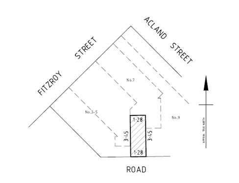
2. EXECUTIVE Summary
2.1 The Road is approximately 4.4 square metres in total area and adjoins the rear of 3-5, 7, 9, and 15 Fitzroy Street, St Kilda VIC 3182.
2.2 The Road is listed on Council’s Register of Public Roads, also known as part R3571.
2.3 The owner of 3-5, 7, 9, and 15 Fitzroy Street, St Kilda VIC 3182 (Owner) has requested that Council discontinues and sells the Road to them (Proposal).
2.4 At its meeting on 16 August 2023, Council resolved to:
· Remove the Road in question from the Register; and
· Commence the statutory procedures and give notice pursuant to sections 207A and 223 of the Act of its intention to discontinue and sell the Road to the Owner for market value.
2.5 On 22 November 2023, Council gave public notice by publication in The Age newspaper and on Council’s website.
2.6 Council did not receive any submissions in response to the public notice.
2.7 Council is now able to consider whether to discontinue and sell the Road to the Owner.
2.8 Officers recommend that Council discontinues the Road and sells it to the Owner, for market value, which is $30,000 (ex GST) plus reimbursement of Council’s costs to facilitate this transaction. The proceeds of the sale will be held in Council’s Strategic Property Reserves to support the acquisition and development of the property portfolio.
|
That Council: Having considered that there were no submissions in response to the public notice regarding Council’s proposal to discontinue the road being the land contained in certificate of title volume 2591 folio 074 (described as Road R1 on plan of subdivision LP29616) (Road): 3.1 Resolves to discontinue the Road as it considers that the Road is not reasonably required for public use for the following reasons: · It is enclosed between the walls and fences of the adjoining properties, and only accessible on the southern boundary; · It is only open to the general public for pedestrian access to the rear of the adjoining properties at 3-5 and 7 Fitzroy Street; · It is not open to the general public for vehicular access; and · It does not form part of a thoroughfare for pedestrian or vehicular traffic to any other public road; 3.2 Resolves to sell the discontinued Road for market value plus reimbursement of Council’s costs to facilitate this transaction to the adjoining owner of 3-5, 7, 9, and 15 Fitzroy Street, St Kilda (Owner); 3.3 Notes that proceeds from the sale will go into Council’s Strategic Property Reserves used to support the acquisition and development of the property portfolio; 3.4 Directs that a notice pursuant to clause 3 of Schedule 10 of the Local Government Act 1989 is published in the Victorian Government Gazette; 3.5 Authorises the Chief Executive Officer or their delegate to negotiate, approve, and enter into such documentation to complete the discontinuance, sale, and transfer of the Road as described; 3.6 Directs that the Chief Executive Officer or their delegate signs an authorisation allowing Council’s solicitors to execute transfer documents and any other documents required to be signed on Council’s behalf in connection with the transfer of the discontinued Road to the Owner; 3.7 Directs that any easements, rights or interests required to be created or saved over the Road by any public authority be done so and not be affected by the discontinuance and sale of the Road; and 3.8 Directs that the Owner be required to consolidate the title to the discontinued Road with the title to the Owner’s land (or such part of it approved by Council) within 12 months of the date of the transfer of the discontinued Road. |
4. KEY POINTS/ISSUES
4.1 The Road has an approximate area of 4.4 square metres and is shown as Road R1 on plan of subdivision LP29616 (as attached).
4.2 The Owner has requested that Council discontinues the Road and sells the Road to them (Proposal).
4.3 The Owner has agreed to pay Council’s costs and disbursements associated with the proposed discontinuance of the Road, together with the market value for its transfer of the discontinued Road to them.
4.4 At its meeting on 16 August 2023, Council resolved to:
· Remove the Road in question from the Register; and
· Commence the statutory procedures and give notice pursuant to sections 207A and 223 of the Act of its intention to discontinue and sell the Road to the Owner for market value plus legal fees.
4.5 On 22 November 2023, Council gave public notice by publication in The Age newspaper and on Council’s website.
4.6 Council did not receive any submissions in response to the public notice.
4.7 Council is now able to consider whether to discontinue and sell the Road to the Owner.
4.8 The Road is shaded red on the locality plan shown below.
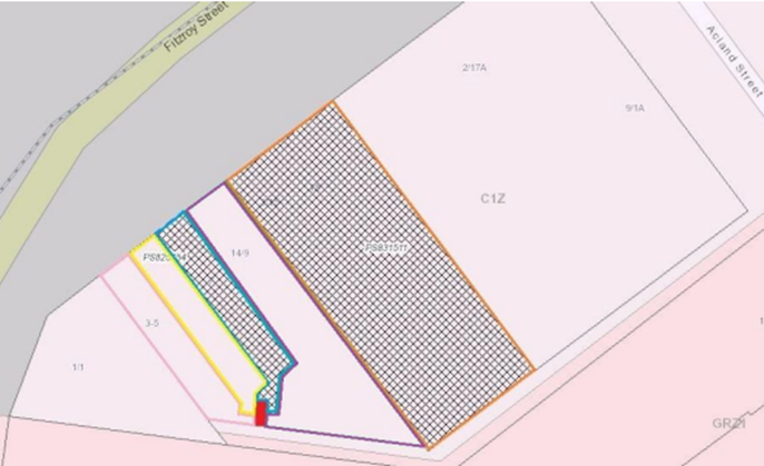
4.9 The Road adjoins the rear of the following properties, all of which are registered in the name of the Owner (Owner’s Property):
· 3-5 Fitzroy Street, St Kilda, being the land contained in certificates of title 8198 folio 555 and volume 8500 folio 030 and shown delineated pink and yellow respectively on the Locality Plan;
· 7 Fitzroy Street, St Kilda, being the land contained in certificate of title 8198 folio 557 and shown delineated blue on the Locality Plan;
· 9 Fitzroy Street, St Kilda, being the land contained in certificate of title 8198 folio 556 and shown delineated purple on the Locality Plan; and
· 15 Fitzroy Street, St Kilda, being the land contained in certificate of title 7734 folio 161 and shown delineated orange on the Locality Plan.
4.10 The Road is the land contained in in certificate of title volume 2591 folio 074, being Road R1 on plan of subdivision LP26916 (as attached).
4.11 Council has statutory power to consider discontinuing the Road.
4.12 If the Road is discontinued, the land will vest in Council free of road status (section 207B of the Act).
ADJOINING PROPERTIES
4.13 All properties which directly adjoin the Road are the Owner’s Properties.
4.14 The only other property located near the Road (but does not directly adjoin the Road) is 1 Fitzroy Street, St Kilda (1 Fitzroy Street), which is not one of the Owner’s Properties.
4.15 The consent of the owner of 1 Fitzroy Street is not considered required, as:
· The Road does not abut or adjoin 1 Fitzroy Street;
· 1 Fitzroy Street does not have any legal abuttal on title or any right of carriageway over the Road; and
· The Road is not required for access to any part of 1 Fitzroy Street.
PROPOSAL
4.16 The Owner has agreed to pay Council’s costs and disbursements associated with the proposed discontinuance of the Road, together with the market value for the transfer of the discontinued Road to the Owner.
4.17 If the Road is discontinued and sold to the Owner, Council will require the Owner to consolidate the title to the discontinued Road with the title to the Owner’s Property within 12 months of the date of transfer of the Road to the Owner, at the Owner’s expense.
ANALYSIS
4.18 It is considered that the Road in question is no longer reasonably required for general public use as it:
· Is part of a laneway which is wholly enclosed between the walls and fences of the adjoining properties, and behind gates at its northern and southern ends;
· Is not open to the general public for pedestrian or vehicular access; and
· Does not form part of a thoroughfare for pedestrian or vehicular traffic to any other public road.
5. CONSULTATION AND STAKEHOLDERS
5.1 The following statutory authorities have been advised of the proposed discontinuance of the Road and have been asked to respond to the question of whether they have any existing assets in the Road, which should be saved under section 207C of the Act:
· Port Phillip City Council;
· Citipower;
· Multinet Gas;
· Melbourne Water;
· South East Water; and
· Telstra Corporation.
5.2 Council’s Asset Management Team has advised that Council has no assets in or above the Road and no objection to the Proposal.
5.3 Melbourne Water, South East Water, Telstra Corporation, CitiPower, have advised that they have no objection to the Proposal.
5.4 Multinet Gas did not respond to Council’s correspondence regarding assets in or above the Road prior to the requested deadline. Council is proceeding on the basis that Multinet Gas does not have any right, power, or interest which it wishes to be saved under section 207C of the Act.
5.5 Council has notified the community of the Proposal through a public notice in The Age newspaper on 22 November 2023, and on Council’s website inviting submissions in accordance with section 223 of the Act.
5.6 The deadline for submissions was on 20 December 2023.
5.7 No submissions were received by Council in response to the public notice.
6. LEGAL AND RISK IMPLICATIONS
6.1 Under clause 3 of Schedule 10 of the Act, a council has the power to discontinue roads located within its municipality and sell the land from that road or retain the land for itself. Council must first give notices in accordance with sections 207A and 223 of that Act.
6.2 Under section 114 of the Local Government Act 2020 (2020 Act), a council must comply with that section if it sells or exchanges land. Section 114 requires that (unless section 116 applies) before selling or exchanging land, a council must at least 4 weeks prior to the sale or exchange publish notice of its intention to do so on council’s website and in any other prescribed manner, undertake a community engagement process in accordance with its community engagement policy, and obtain a valuation from a person qualified under section 13DA(2) of the Valuation of Land Act 1960 made not less than 6 months prior to the sale or exchange.
6.3 Council has a Discontinuance and Sale of Roads Policy (Policy) that enables roads that are no longer required for public access to be discontinued and sold to the adjoining owner(s).
7. FINANCIAL IMPACT
7.1 The Owner has agreed to acquire the Road for its market value (plus GST). If Council proposes to transfer the Road, it will need a current valuation of the Road in accordance with the 2020 Act. This is in accordance with Council’s Policy.
7.2 The Owner has agreed to pay Council’s costs and disbursements associated with the proposed discontinuance of the Road.
7.3 As at 20 November 2023, the market valuation of the land in the Road was $6,000 per square metre excluding GST totalling $30,000 excluding GST. The valuation was undertaken on 20 November 2023. In accordance with Council’s Policy and previous sales of roads, the value attributed to the land in the Road is based on the following assumptions:
· The Road is valued on a “direct comparison on land value rate”, taking into consideration restrictions due to the shape and location of the site, and the limited width of the site restricts potential redevelopment of the site in isolation without consolidation with adjoining property; and
· No discount is applicable to the full land value due to the limited purchasing market for the Road.
8. ENVIRONMENTAL IMPACT
8.1 The Proposal has no detrimental environmental implications.
9. COMMUNITY IMPACT
9.1 Council will facilitate the discontinuance and sale of roads where appropriate consultation has occurred, legislative requirements have been met and it is considered that road discontinuance and sale is in the best interest of the wider community.
9.2 The proposed discontinuance and sale of the Road will enable the land in the Road to be re-purposed.
9.3 If Council resolves to discontinue and sell the Road, proceeds from the sale will go into Council’s Strategic Property Reserves used to support the acquisition and development of the property portfolio.
10. ALIGNMENT TO COUNCIL PLAN AND COUNCIL POLICY
10.1 The proposal aligns with the Strategic Direction 5 – Well Governed in the Council Plan 2021-2031: A City that is a leading local government authority, where our community and our organisation are in a better place as a result of our collective efforts.
11. IMPLEMENTATION STRATEGY
11.1 TIMELINE
· If the Proposal is approved:
o a notice will be published in the Victorian Government Gazette to formally discontinue the Road; and
o a contract of sale for the discontinued Road and transfer of the discontinued Road pursuant to section 207D of the Act will be prepared by Council’s solicitors.
11.2 COMMUNICATION
The public notification process has provided the community with the opportunity to make submissions in respect of the Proposal. Having considered that no submissions were received, Council may now determine whether to discontinue and sell the Road.The Owner will be advised of the final Council decision and the reasons for it within five (5) days of the Council meeting.
12. OFFICER DIRECT OR INDIRECT INTEREST
12.1 No officers involved in the preparation of this report have any material or general interest in the matter.
|
ATTACHMENTS |
Meeting of the Port Phillip City Council
6 March 2024
|
Audit and Risk Committee - Biannual Report as at 31 December 2023 AND Annual Review of the Committee Charter |
|
|
Executive Member: |
Joanne McNeill, Executive Manager, Governance and Organisational Performance |
|
PREPARED BY: |
Julie Snowden, Coordinator Risk and Assurance |
1. PURPOSE
1.1 To adopt the updated Audit and Risk Committee Charter 2023
1.2 To present to the Audit and Risk Committee Biannual Report as of 31 December 2023.
2. EXECUTIVE Summary
2.1 Council is required by the Local Government Act (LGA) 2020 to establish an Audit and Risk Committee (the Committee) as an advisory committee of Council.
2.2 Under the LGA, the Audit and Risk Committee must prepare a biannual report on activities to Council and must prepare and approve an Audit and Risk Committee Charter (the Charter) which sets out the Committee’s objective, authority, tenure, role and responsibilities, reporting and administrative arrangements, with the Charter to be reviewed annually.
2.3 This paper satisfies this reporting requirement and the annual review of the charter for adoption by Council.
2.4 The last update provided to Council was the presentation of the Audit and Risk Committee Biannual report as of 30 June 2023.
|
That Council: 3.1 Adopts the updated Audit and Risk Committee Charter (Attachment 1) 3.2 Notes that the updated Audit and Risk Committee Charter will be published on Council’s website. 3.3 Notes the Audit and Risk Committee Biannual Report as of 31 December 2023, which details activities of the Committee covering scheduled meetings held on 31 August 2023 and 5 December 2023. |
4. KEY POINTS/ISSUES
4.1 Proposed changes to the Charter
4.1.1 The major changes to the Committee Charter in 2023 include:
· Updated information relating to WWCC requirements;
· Amended officer title/s where required;
· Updated date Charter was approved by Council;
· Updated next review date.
4.1.2 The Audit and Risk Committee adopted the proposed changes to the Charter for subsequent Council endorsement pending a decision being made on working with children checks (wwcc) for Councillors on the Audit and Risk Committee.
4.1.3 At 6 December 2023 Council Meeting, included in the annual appointments of Councillors to Committees report, in line with the appropriate risk assessments undertaken, Councillors agreed Committees whose independent members are remunerated by Council should hold a WWCC. The Charter has been updated accordingly.
4.2 Matters considered by the Committee at its 31 August 2023 meeting were:
4.2.1 Committee only time
The Committee and the external and internal auditor discussed their respective audit activities, with the Committee noting full assistance had been provided by management.
4.2.2 Chief Executive Officer’s Report
The Committee noted the overview from the CEO on key activities, including an increased focus on getting the organisation aligned with the Council Plan and Budget and CEO Performance Agreement with Council, cascading down to individual performance plans, an update on our response to contractor performance of new waste provider, Fishermans Bend advocacy priorities and an uplift in our strategic approach to risk management.
4.2.3 Strategic Risk and Internal Audit (SRIA)
The Committee noted the regular SRIA update and the Internal Audit Recommendations Tracking Status Report.
4.2.4 Assurance Activities Update
The Committee discussed the audit findings from the Data Lifecycle Management and Climate Change Adaption audits and signed off on scopes for the following audits: Building Essential Safety Measures, Business Function Risk Assurance Map (BFRAM), Fraud and Corruption Control Framework and Revenue Assurance Assessment. The Committee also noted the Internal Audit Plan status report 2022/23.
4.2.5 External Audit
External representatives from BDO, new agent appointed by the Victorian Auditor General’s Office (VAGO) discussed the performance statements and interim closure reports, commending the Chief Financial Officer and the finance team for their efforts. The Committee thanked them for their excellent summary.
The Committee noted the management representation letter commending management on their excellent certification process and recommended the annual accounts and the performance statement for adoption by Council in principle. The Committee also noted the review of Asset Revaluation and Depreciation Methods report.
4.2.6 Compliance Monitoring
The Committee noted the regular Compliance update, the biannual Safety and Wellbeing update the Procurement update including an update on the Procurement Framework and the annual Procurement and Vendor Compliance update, an update on Councillor Expenses and an update of the Register of Delegations,
4.2.7 Financial Monitoring
The Committee noted the financial sustainability standing report, the Rates Collected and Rates Outstanding Report, the Debtor Management Policy/Procedure and endorsed the Council Organisation Expense Policy.
4.2.8 Supplementary Reports
The Committee noted the following reports: Digital and Technology Services (DTS) six-monthly update, Gifts and Hospitality update and an update on Fishermans Bend.
4.3 Matters considered by the Committee at its 5 December 2023 meeting were:
4.3.1 Committee only time
The Committee discussed agenda items and key discussion topics.
4.3.2 Chief Executive Officer’s Report
The Committee noted the overview from the CEO on key activities, including an update on the following organisational key topics: People and Culture, Customer and Community, Community Engagement, Governance and Advocacy and Program and Project Delivery.
4.3.3 Strategic Risk and Internal Audit (SRIA)
The Committee noted the regular SRIA update, the Internal Audit Recommendations Tracking Status Report and the annual Insurance Update.
4.3.4 Assurance Activities Update
The Committee discussed the audit findings from the Business Function Risk Assurance Map (BFRAM) and the Fraud and Corruption Prevention audits and signed off on scopes for the following audits: Business Continuity Planning / IT Disaster Recovery and Parking Management Internal Audit. The Committee also noted the Internal Audit Plan status report 2022/23, the Risk and Issues Brief and the Internal Audit Charter.
4.3.5 External Audit
There Committee noted the final VAGO Management Letter.
4.3.6 Compliance Monitoring
The Committee noted the regular Compliance update and the Health Safety and Wellbeing Q1 update.
4.3.7 Financial Monitoring
The Committee noted the financial sustainability standing report and the quarterly Financial / Portfolio Deliverability Review.
4.3.8 Supplementary Reports
The Committee noted a Child Safe Incident update.
4.3.9 Performance Evaluation
The Committee noted the results of the annual Self-Assessment Survey on its own performance.
4.3.10 Membership Expirations
The Committee: nominated an independent member as Chairperson for the 2024 calendar year and reappointed an independent member for a further 3 year term - considered by Council under separate report 7 February 2023.
5. ALIGNMENT TO COUNCIL PLAN AND COUNCIL POLICY
5.1 Strategic Direction 5 - Well Governed Port Phillip: Supporting sound decision-making through transparency, accountability, community participation, risk management and compliance.
6. OFFICER DIRECT OR INDIRECT INTEREST
6.1 No officers involved in the preparation of this report have any material or general interest in the matter.
|
ATTACHMENTS |
Meeting of the Port Phillip City Council
6 March 2024
|
Status of Council Decisions and Questions Taken on Notice recorded by Council: 1 October - 31 December 2023 |
|
|
Executive Member: |
Joanne McNeill, Executive Manager, Governance and Organisational Performance |
|
PREPARED BY: |
Rebecca Purvis, Senior Council Business Advisor |
1. PURPOSE
1.1 To provide Councillors with an update on the status of all Resolutions passed by Council at Council and Planning Committee Meetings between 1 October – 31 December 2023 and the status of actions that were previously reported as outstanding in the last quarterly status report.
1.2 To provide Council with an update on the status of Questions Taken on Notice during Council Meetings from 1 October – 31 December 2023 and the status of questions taken on notice that were previously reported as outstanding in the last quarterly status report.
2. EXECUTIVE Summary
2.1 Council Resolutions
2.1.1 The implementation status of Council Resolutions is a vital measure of Council’s performance. This process may also assist reporting for the Local Government Performance Reporting Framework.
2.1.2 There has been a total of 65 Resolutions (decisions) that have been made by Council, in Council and Planning Committee meetings open to members of the public, between the period of 1 October – 31 December 2023. Of these, 4 decisions remain open/outstanding.
2.1.3 There has been a further 9 decisions that have been made in Council and Planning Committee meetings closed to members of the public. These confidential decisions have been completed.
2.1.4 This report includes a further 9 decisions that remain outstanding and a further 5 decisions that have been completed from previous reporting periods (that is, prior to 1 October 2023).
2.1.5 This report is a report in time and is representative of decisions made by Council in the period 1 October – 31 December 2023.
2.2 Questions taken on notice
2.2.1 At each meeting, provision is made at the beginning for members of the public and for Councillors to ask general questions. Questions relating to a topic on the agenda are not permitted during this time however can be asked prior to the discussion of that item. When a question is unable to be responded to at the time, it is taken ‘on notice’ for a response to be provided.
2.2.2 The response status of Questions taken on Notice during Council meetings is a measure of Council’s engagement and communication with the community.
2.2.3 A total of 17 questions were taken on notice during the period 1 October – 31 December 2023 in Council meetings open to members of the public. A copy of the response to each of these questions has been made available on the website. A summary of responses to questions taken on notice during this reporting period are contained in Attachment 3 to this report.
|
That Council: 3.1 Notes the implementation status of Council and Planning Committee Resolutions as contained in Attachments 1 and 2. 3.2 Notes the response status of questions taken on notice during Council Meetings as contained in Attachment 3.
|
4. KEY POINTS/ISSUES
4.1 Accountability is a fundamental requirement of good governance. Council has an obligation to report, explain and be answerable for the consequences of decisions it has made on behalf of the community.
4.2 Reporting on the progress of the implementation of Council resolutions provides Council with the information it needs to demonstrate its accountability to the community.
4.3 Decisions of Council should be implemented in an effective, timely, appropriate, and responsive manner that makes the best use of the available people, resources, and time to ensure the best possible results.
4.4 Council Resolutions
4.4.1 A resolution made by Council is when an officer recommendation or a Councillor’s motion is adopted at a Council Meeting or Planning Committee (i.e., a decision has been made). Once a decision on a recommendation has been made, it turns into a resolution. These resolutions are tracked through an internal system.
4.4.2 Attachments 1 and 2 of this report include a summary of the actions taken to implement resolutions where required, or confirmation that Council has noted items where appropriate. The summary of actions has been compiled and divided into the following categories:
· Status of Resolutions made at Council Meetings – Outstanding
· Status of Resolutions made at Council Meetings and Planning Committee Meetings – Completed
4.4.3 The Status of Resolutions documents include resolution of officer’s reports, notices of motion, petitions and joint letters, and items of urgent business. Resolution of procedural motions (i.e., attendances and apologies, closing the meeting to discuss confidential items) have not been included.
4.4.4 Some of the reasons that resolutions have not been fully implemented may relate to consultation processes being undertaken, awaiting legal advice, or waiting for documents to be executed.
4.4.5 Where it is expected that a resolution may take a longer time to fully implement, the expected completion date has been extended.
4.5 Questions taken on notice
4.5.1 At each meeting, provision is made at the beginning for members of the public and for Councillors to ask general question/s. Questions relating to a topic on the agenda are not permitted during this time but can be asked prior to the discussion of that item. When a question is unable to be responded to at the time, it is taken ‘on notice’ for a response to be provided.
4.5.2 Attachment 3 of this report includes a summary of questions asked and a link to where the responses to those questions has been published on Council’s website.
5. CONSULTATION AND STAKEHOLDERS
5.1 This report provides Council and the community with an update on the implementation of outcomes of council decisions.
6. LEGAL AND RISK IMPLICATIONS
6.1 If decision-making is open and able to be followed by observers, it is more likely that all relevant legal requirements will be complied with.
7. FINANCIAL IMPACT
7.1 There are no financial impacts arising from this report.
8. ENVIRONMENTAL IMPACT
8.1 There are no environmental impacts arising from this report.
9. COMMUNITY IMPACT
9.1 Making decisions and having to account for them in an open and transparent way encourages honest consideration of issues by Councillors and promotes community confidence in the decision-making process.
9.2 Members of the community should be able to follow and understand the decision-making process. This means that they will be able to clearly see where a decision was made, and how this decision was implemented.
10. ALIGNMENT TO COUNCIL PLAN AND COUNCIL POLICY
10.1 Reporting on the progress of council resolutions delivers on Direction 5 of the Council Plan (Well Governed Port Phillip), by providing a transparent and good governance approach to decision making.
10.2 Good decision-making processes helps people feel that Council will act in the community’s overall interest. It also encourages Councils to remember that they are acting on behalf of their community and helps them to understand the importance of having open and ethical processes which adhere to the law and stand up to scrutiny.
11. IMPLEMENTATION STRATEGY
11.1 TIMELINE
Council receives ongoing reporting on the status of implementation of Council Decisions, and questions taken on notice at Council Meetings, on a quarterly basis.
12. OFFICER DIRECT OR INDIRECT INTEREST
12.1 No officers involved in the preparation of this report have a material or general interest in the matter.
|
ATTACHMENTS |
1. Outstanding Decisions as at 31 December 2023 -
Council Meetings 2. Completed Decisisions Council and Planning Committee
Meetings - 1 October to 31 December 2023 |
Meeting of the Port Phillip City Council
6 March 2024
14. Notices of Motion
Nil
15. Reports by Councillor Delegates
11. Urgent Business
17.1 Discussion papers from the Department of Transport and Planning - Modernising Parking Requirements & Improving Residential Development Standards for Small Lots.......... 163
17.2 Provision of Recycling Processing Services........... 819
RECOMMENDATION
That Council resolves to move into confidential to deal with the following matters pursuant to section 66(2) of the Local Government Act 2020:
17.1 Discussion papers from the Department of Transport and Planning - Modernising Parking Requirements & Improving Residential Development Standards for Small Lots
3(1)(c) land use planning information, being information that if prematurely released is likely to encourage speculation in land values.
Reason:
Proposed changes to the planning scheme regarding
parking and
small lot requirements may impact property values or development decisions
17.2 Provision of Recycling Processing Services
3(1)(a). Council business information, being information that would prejudice the Council's position in commercial negotiations if prematurely released
3(1)(g(i)) private commercial information, being information provided by a business, commercial or financial undertaking that relates to trade secrets
3(1)(g(ii)) private commercial information, being information provided by a business, commercial or financial undertaking that if released, would unreasonably expose the business, commercial or financial undertaking to disadvantage.
Reason:
The report contains Commercial sensative material which will allow non successful applicants the oppurtunity to reverse engineer the successful pricing.