Meeting of the Port Phillip City Council
18 June 2025
|
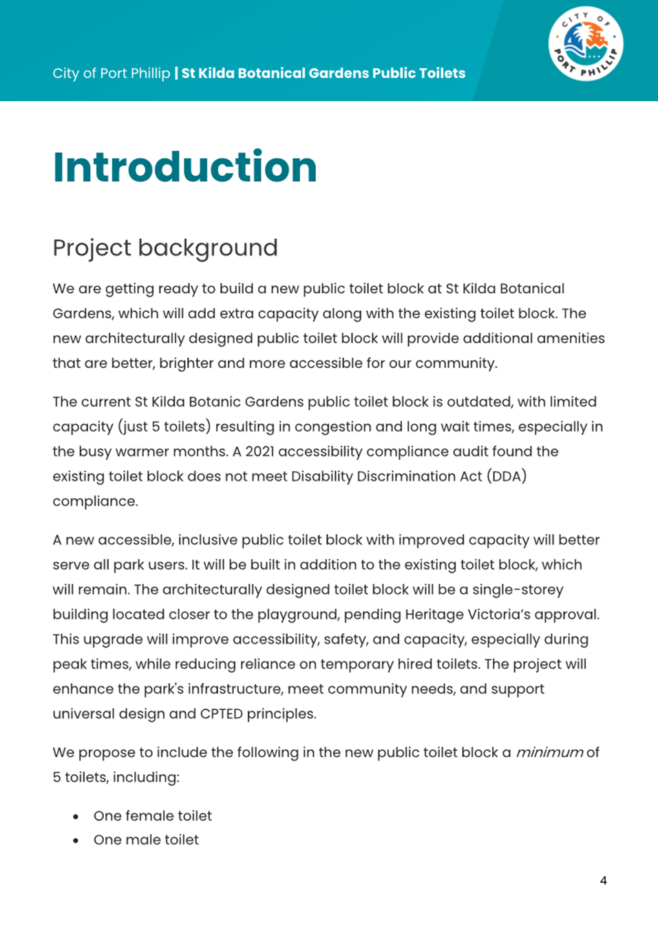
Welcome Welcome to this Meeting of the Port Phillip City Council. Council Meetings are an important way to ensure that your democratically elected representatives are working for you in a fair and transparent way. They also allow the public to be involved in the decision-making process of Council.
About this meeting There are a few things to know about tonight’s meeting. The first page of tonight’s Agenda itemises all the different parts to the meeting. Some of the items are administrative and are required by law. In the agenda you will also find a list of all the items to be discussed this evening. Each report is written by a Council officer outlining the purpose of the report, all relevant information and a recommendation. Council will consider the report and either accept the recommendation or make amendments to it. All decisions of Council are adopted if they receive a majority vote from the Councillors present at the meeting. |
Public Question Time and Submissions Provision is made at the beginning of the meeting for general question time from members of the public. All contributions from the public will be heard at the start of the meeting during the agenda item 'Public Questions and Submissions.' Members of the public have the option to either participate in person or join the meeting virtually via Teams to ask their questions live during the meeting. If you would like to address the Council and /or ask a question on any of the items being discussed, please submit a ‘Request to Speak form’ by 4pm on the day of the meeting via Council’s website: Request to speak at a Council meeting - City of Port Phillip |
|
|
|
|
Meeting of the Port Phillip City Council |
To Councillors
Notice is hereby given that a Meeting of the Port Phillip City Council will be held in St Kilda Town Hall and Virtually via Teams on Wednesday, 18 June 2025 at 6:30pm. At their discretion, Councillors may suspend the meeting for short breaks as required.
AGENDA
1 APOLOGIES
2 MINUTES OF PREVIOUS MEETINGS
Minutes of the Meeting of the Port Phillip City Council 21 May 2025.
3 Declarations of Conflicts of Interest
4 Public Question Time and Submissions
5 Councillor Question Time
6 Sealing Schedule
Nil
7 Petitions and Joint Letters........................................ 5
7.1 Petition: Woodgate Street and Boundary Street Lighting.......................................................................... 5
7.2 Petition: Enhancing Argyle Street Precinct.................. 7
7.3 Petition: Urban Forest Precinct Plan.......................... 12
8 Presentation of CEO Report
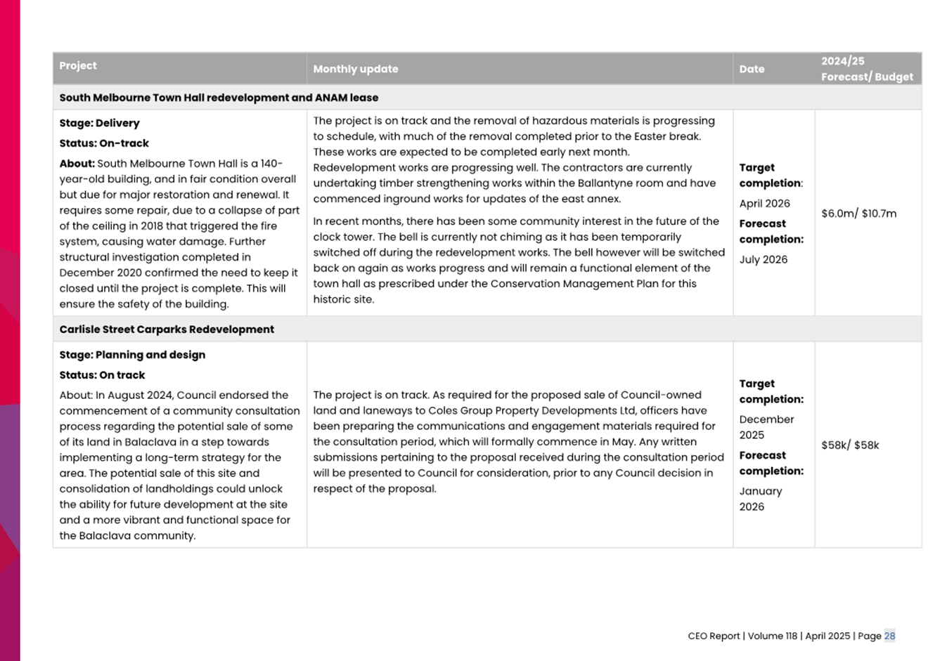
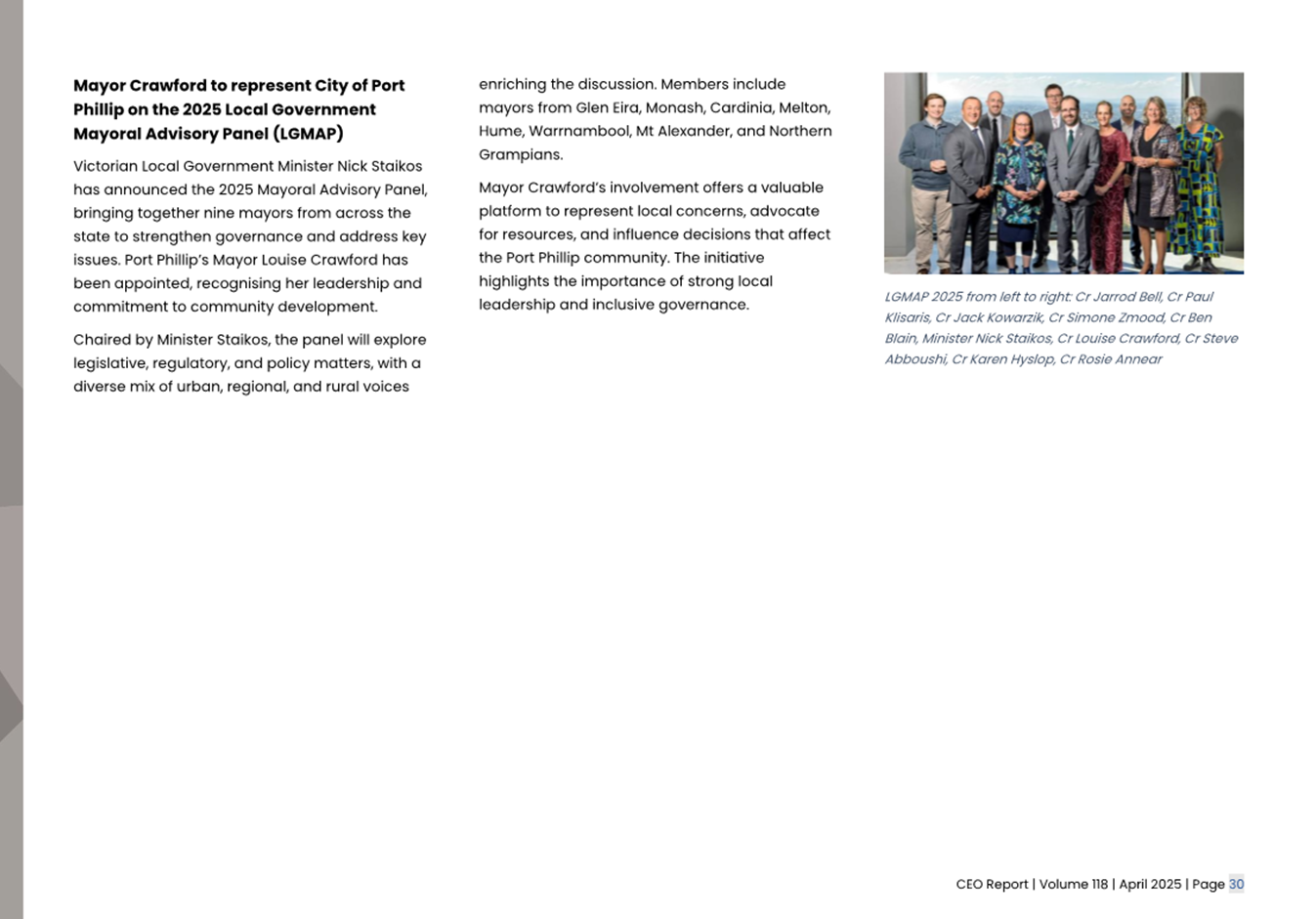
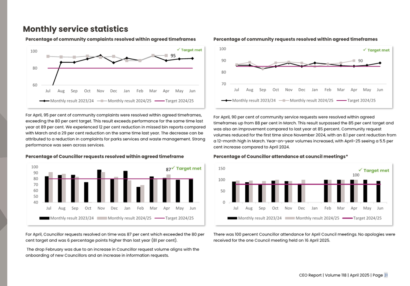
8.1 Presentation of CEO Report Issue 117 - Quarter 3, and CEO Report Issue 118 - April, 2024-25...................... 17
9 Inclusive Port Phillip
9.1 Older Persons Advisory Committee Annual Report 2024 - For Endorsement........................................... 123
10 Liveable Port Phillip
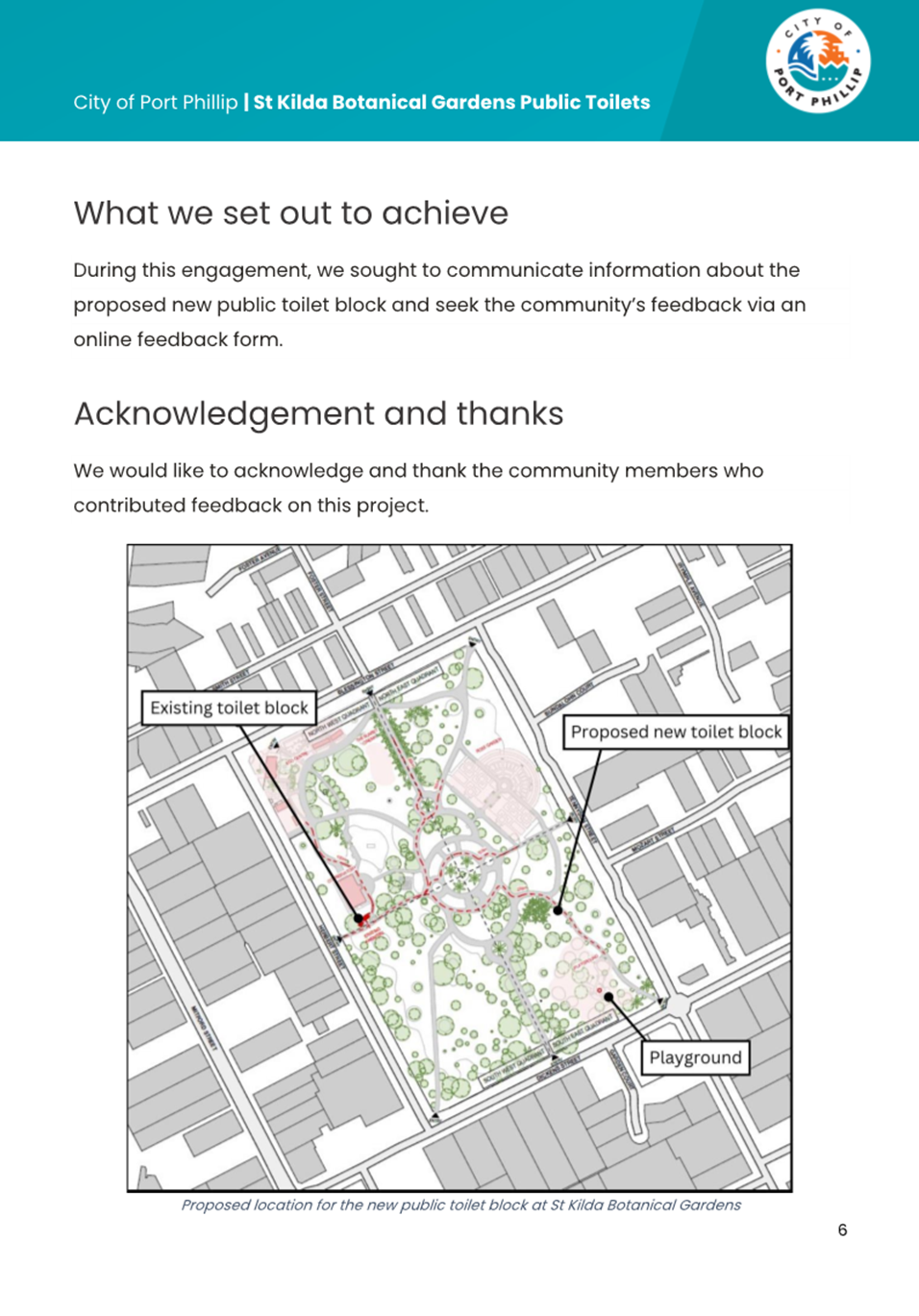
10.1 St Kilda Botanical Gardens Public Toilets Design & Construction.............................................................. 150
10.2 Edwards Park Public Amenities Location................. 215
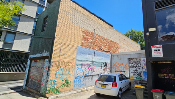
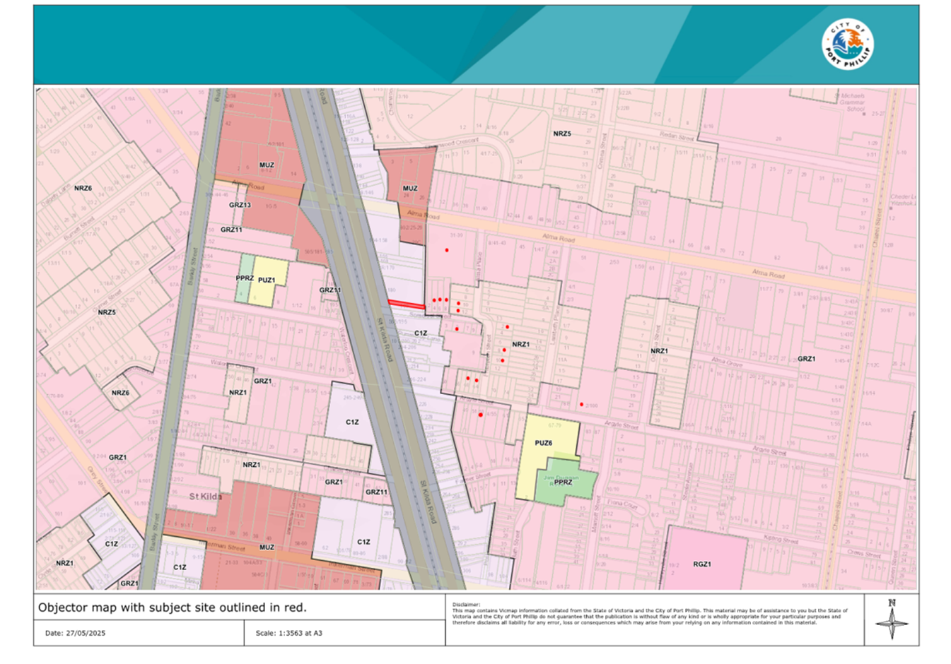
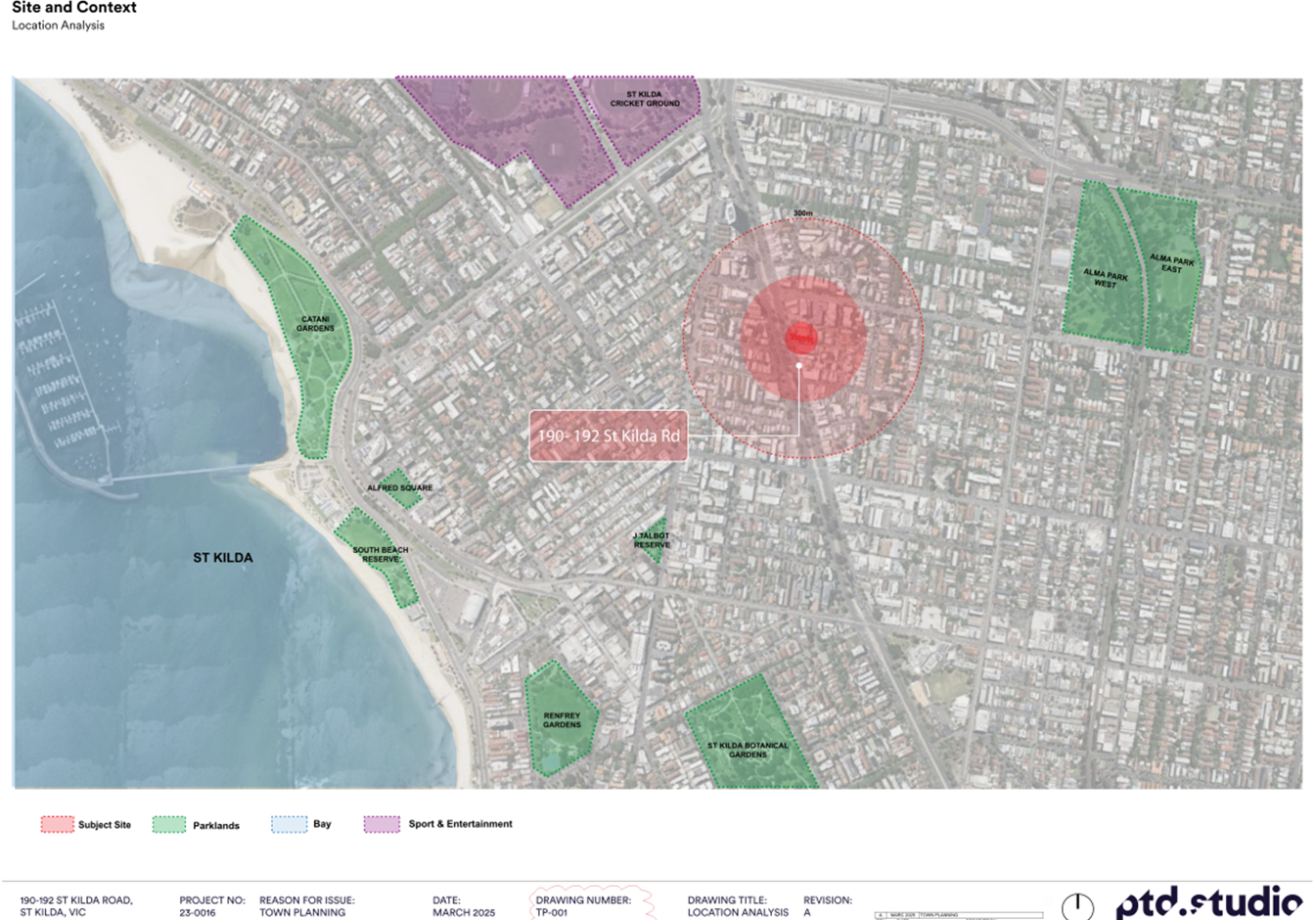
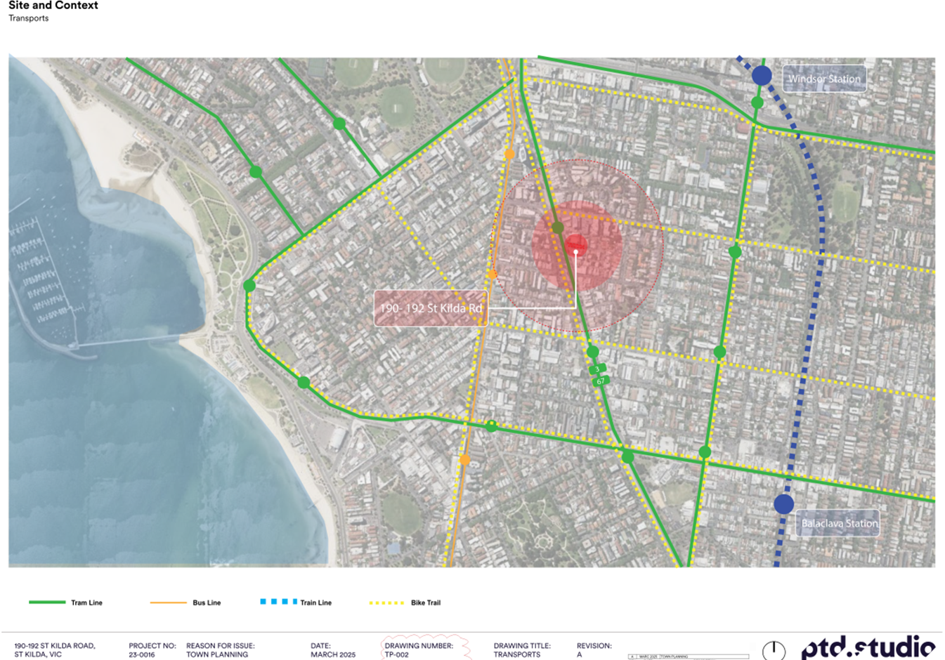
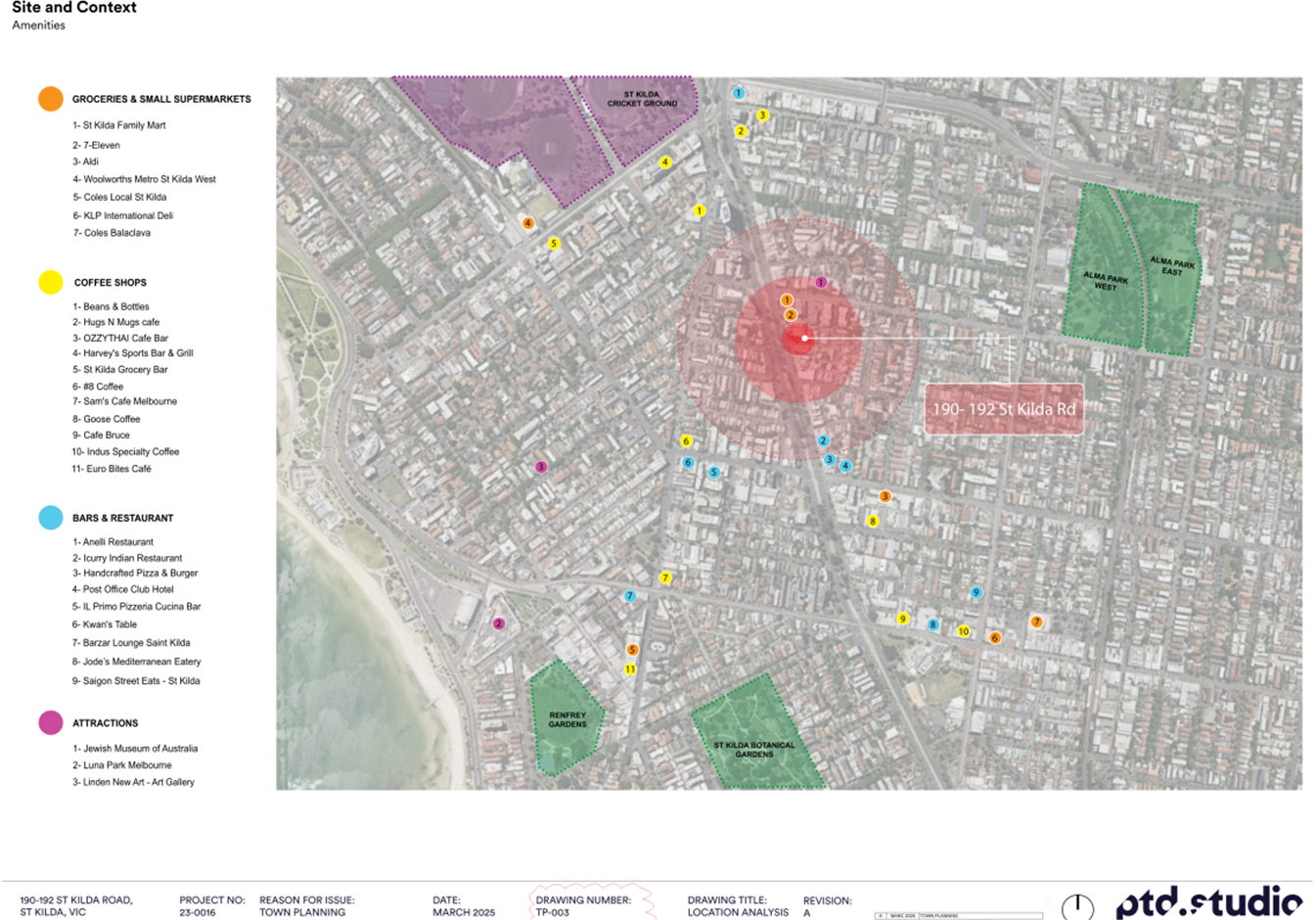
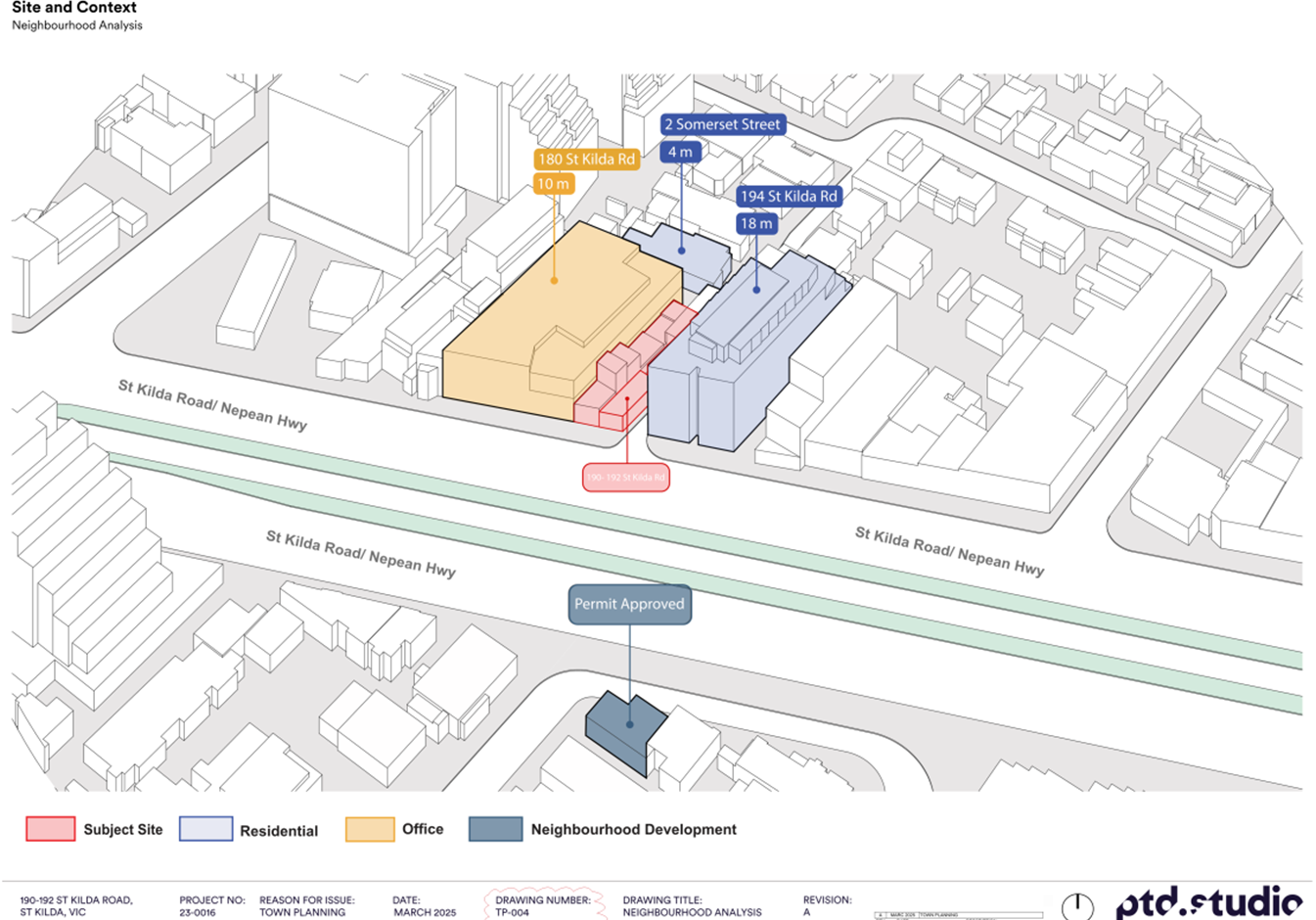
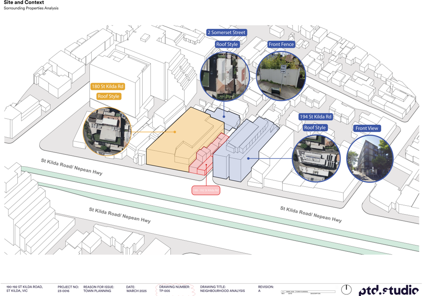
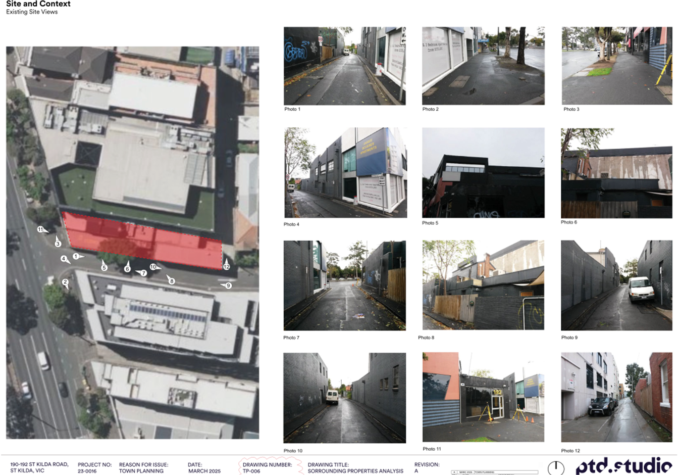
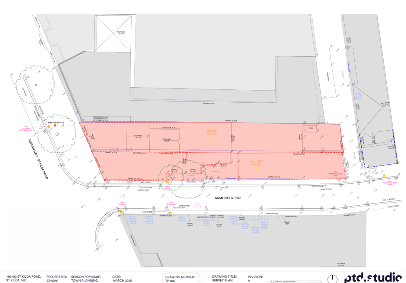
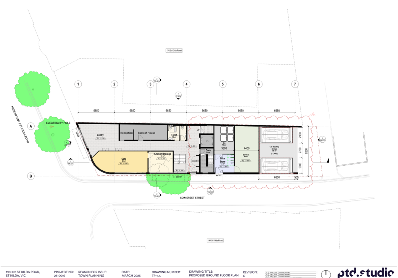
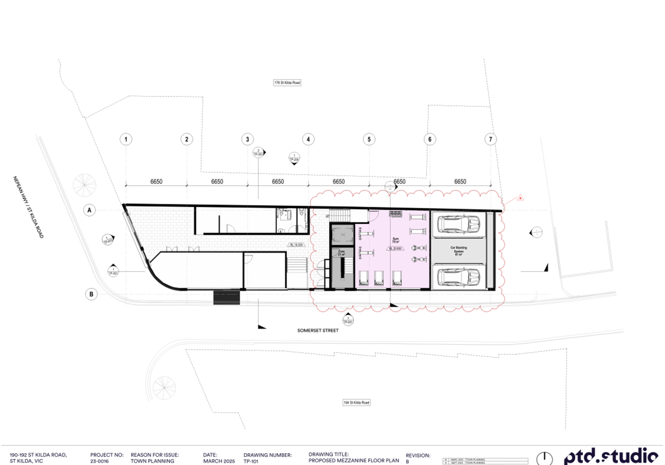
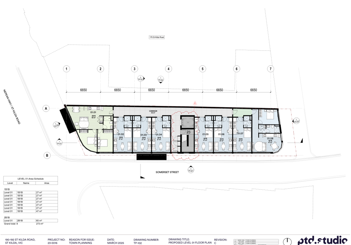
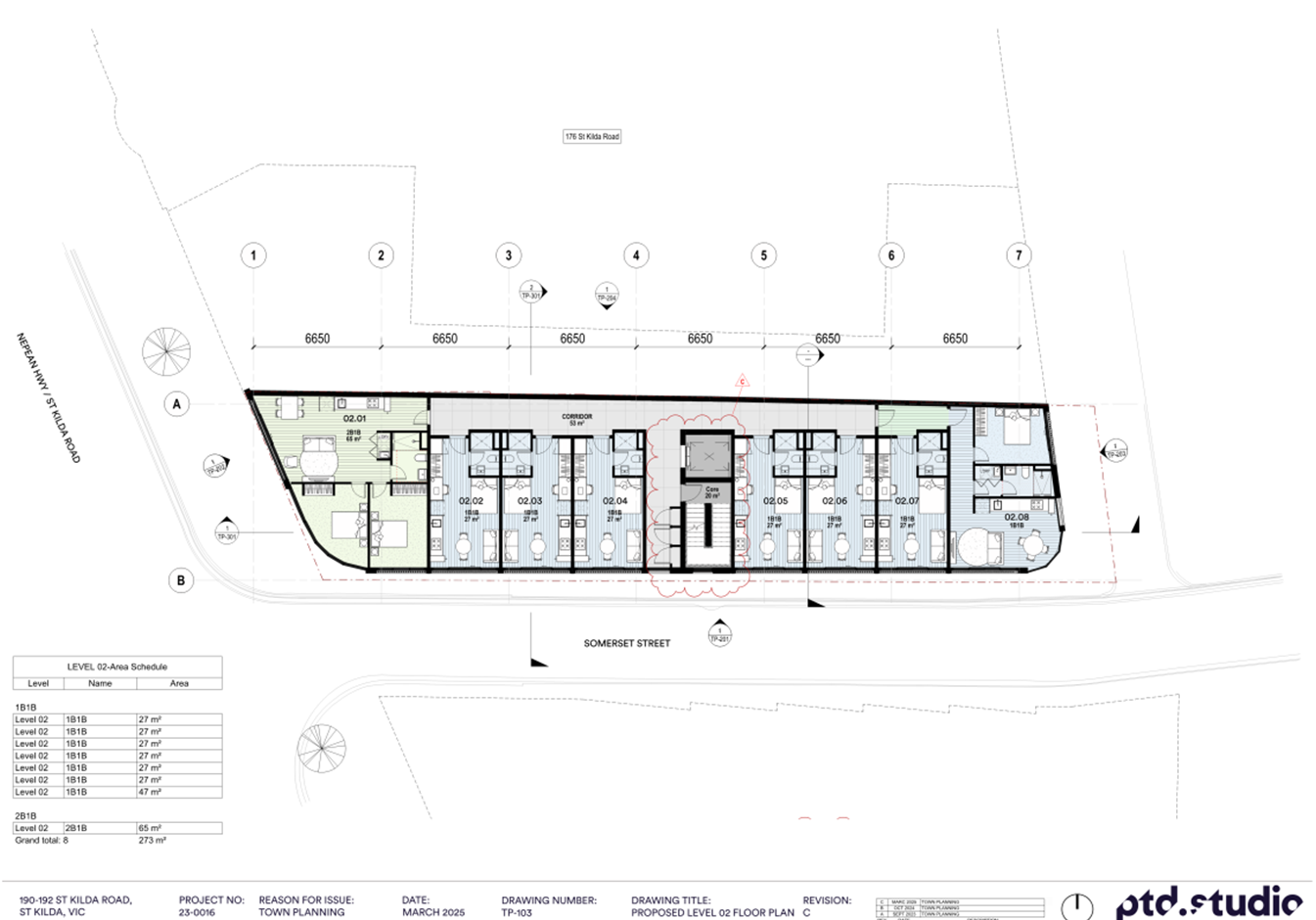
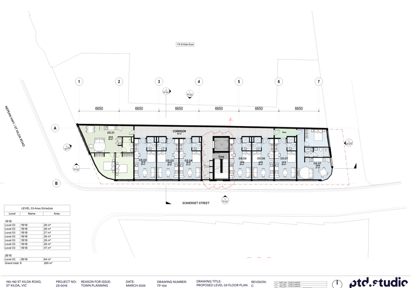
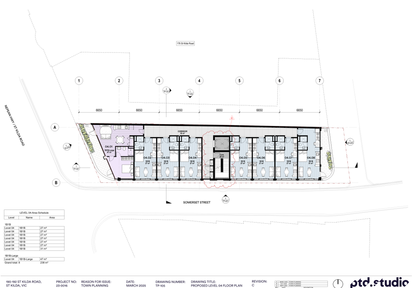
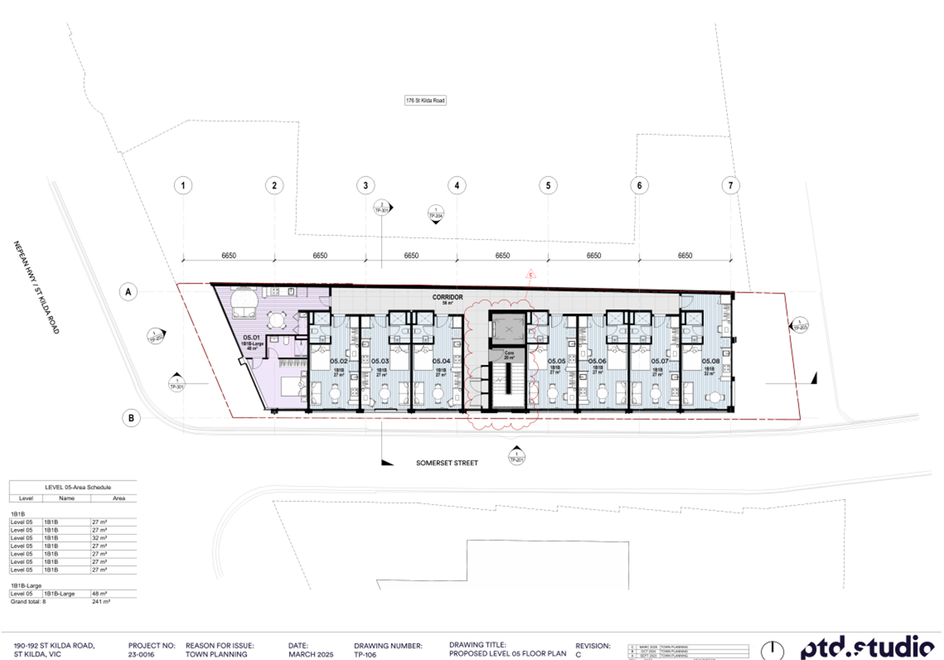
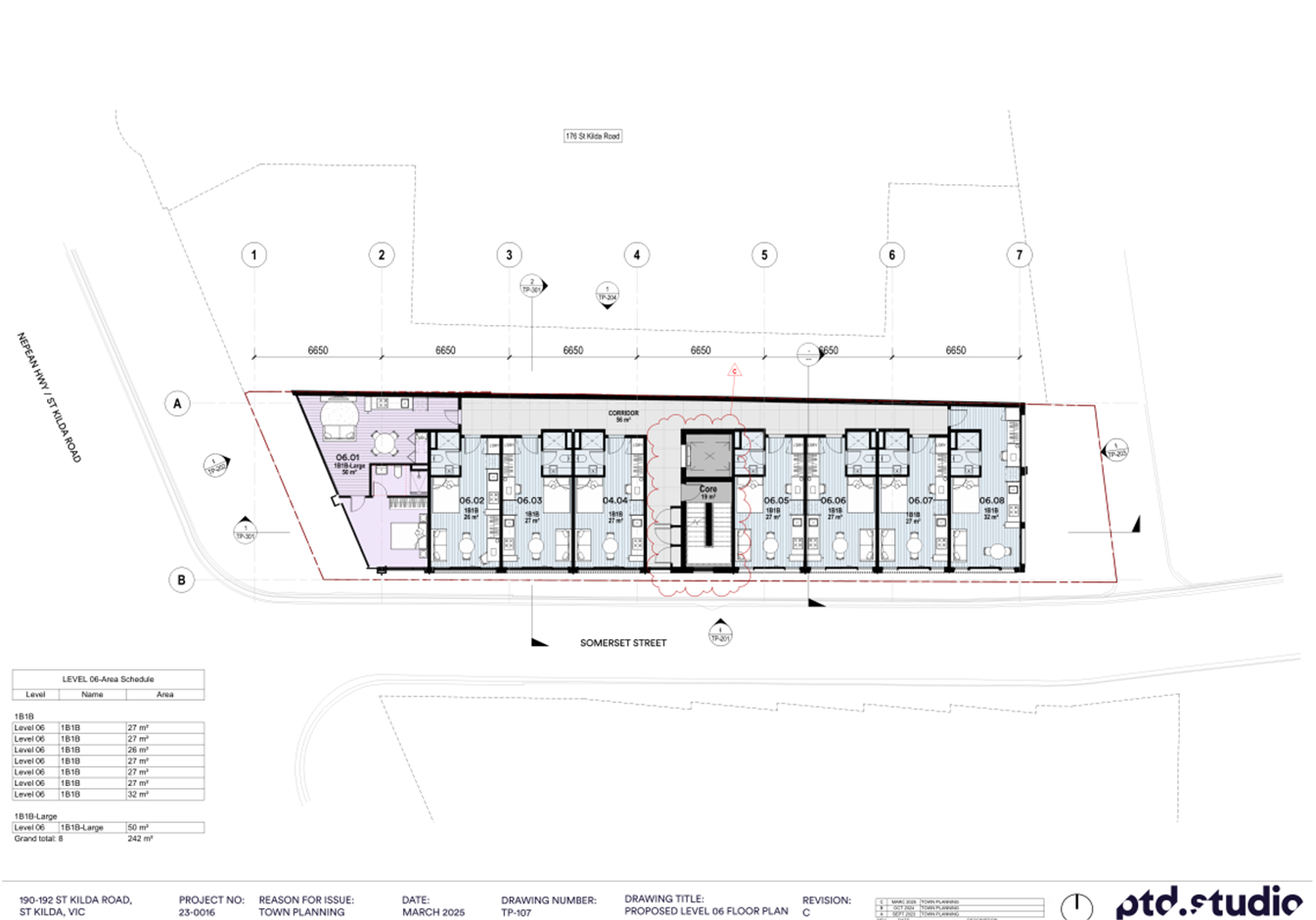
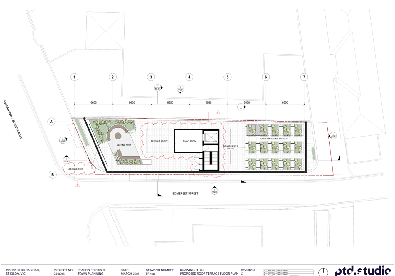
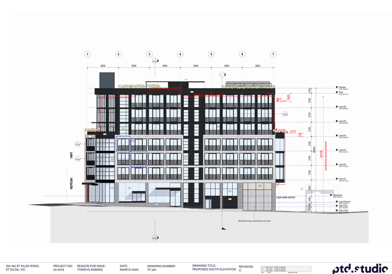
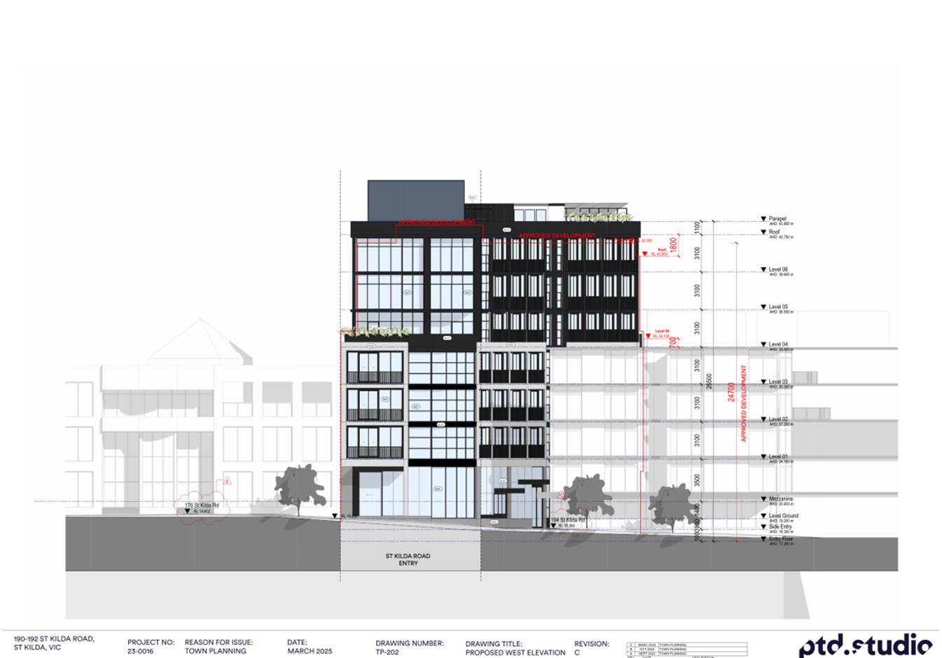
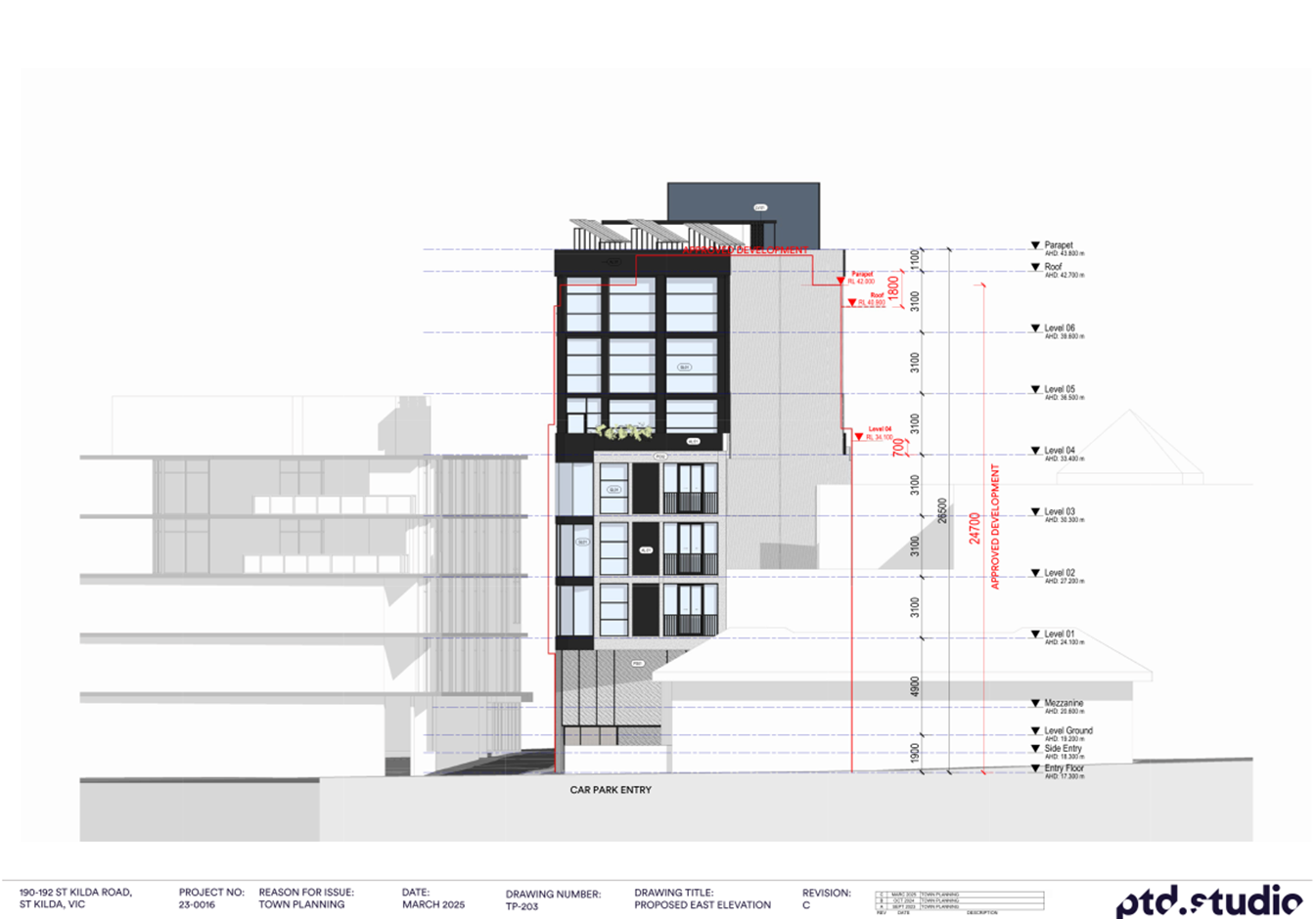
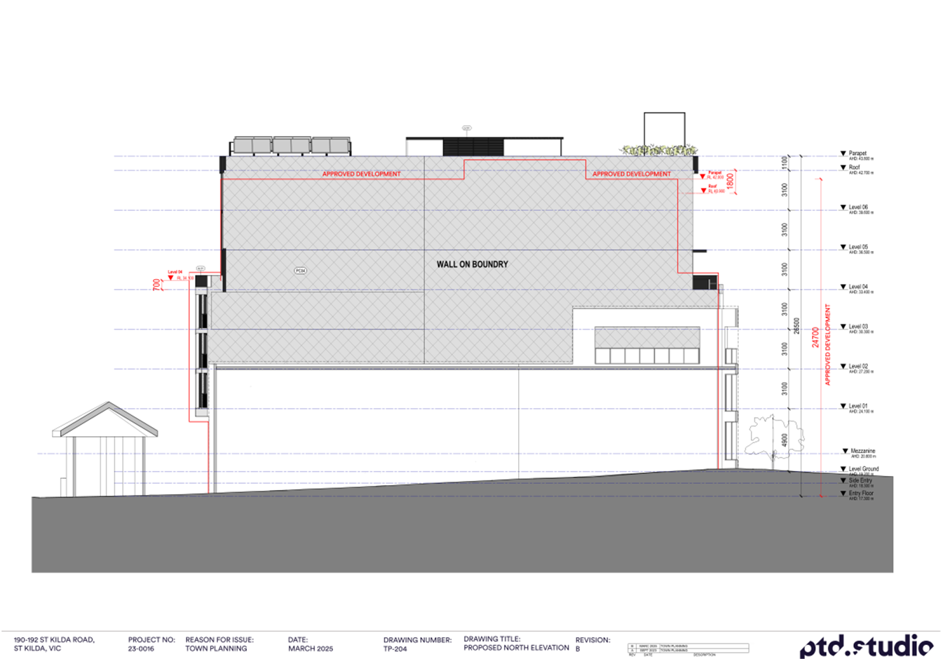
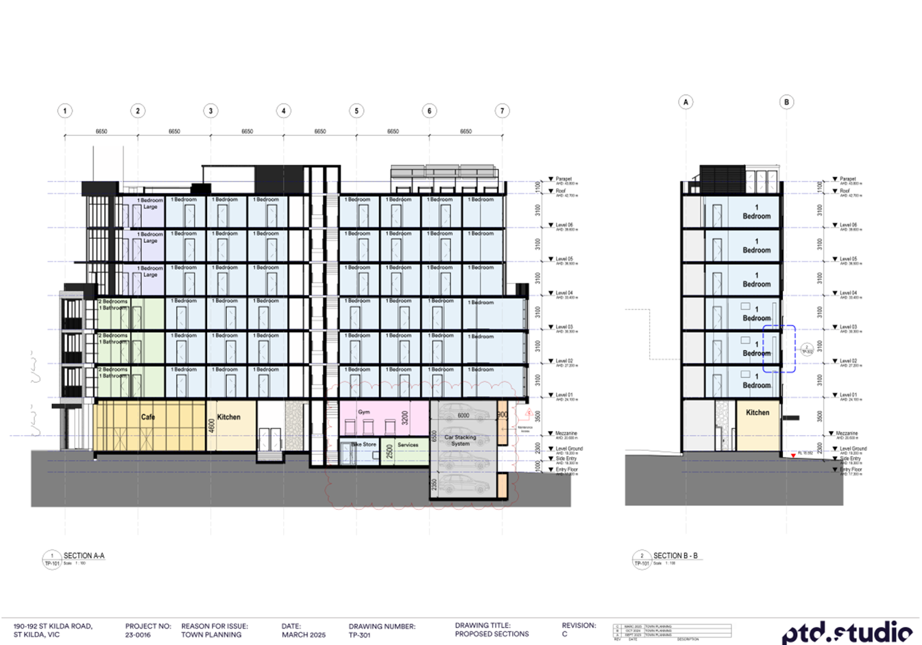
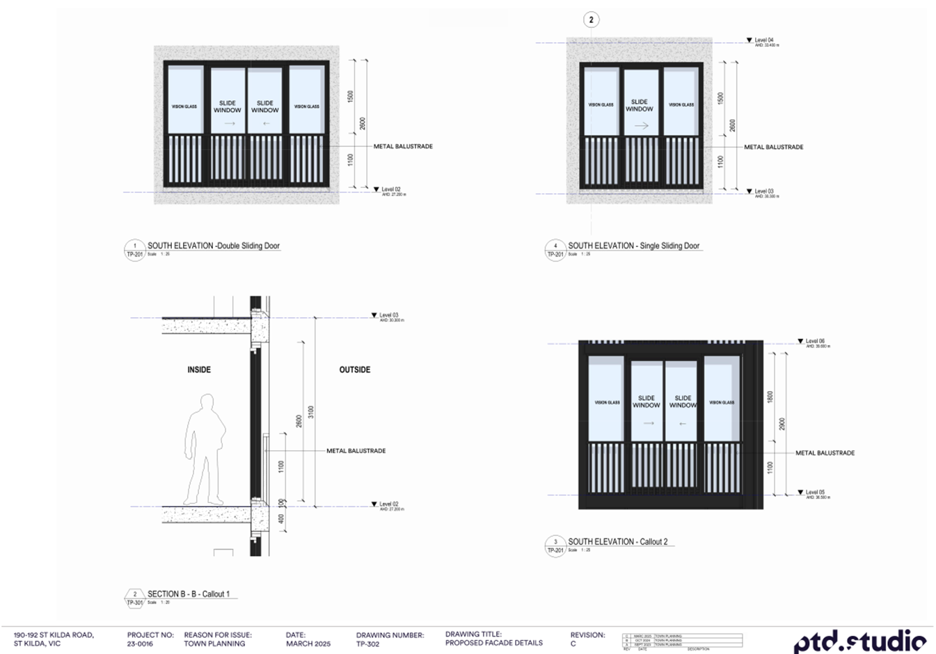
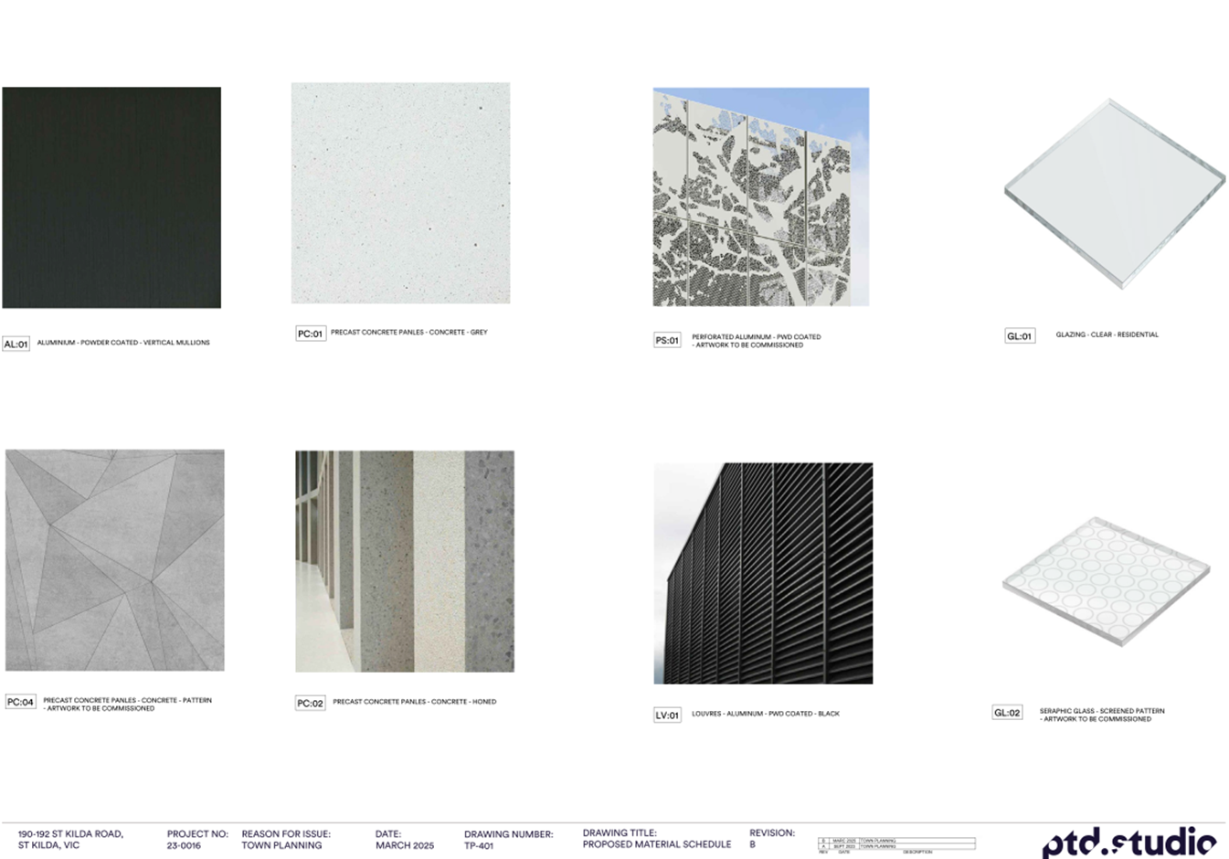
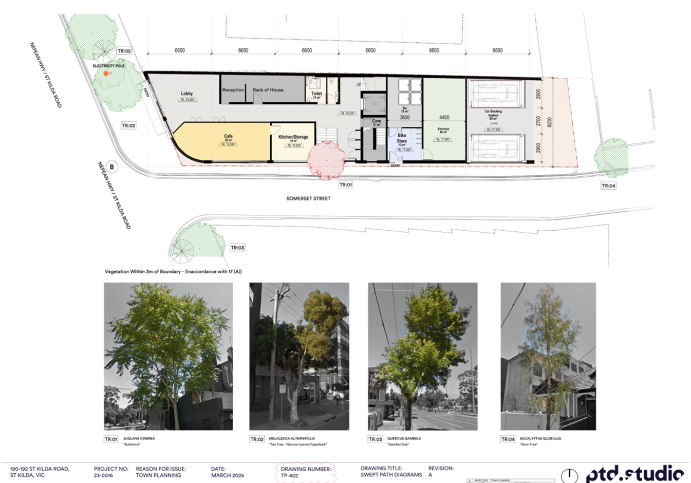
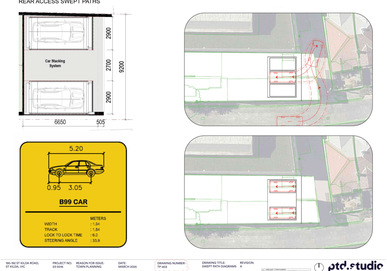
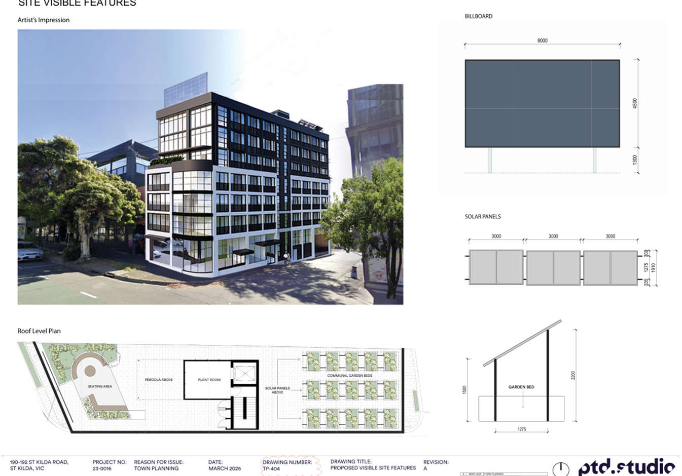
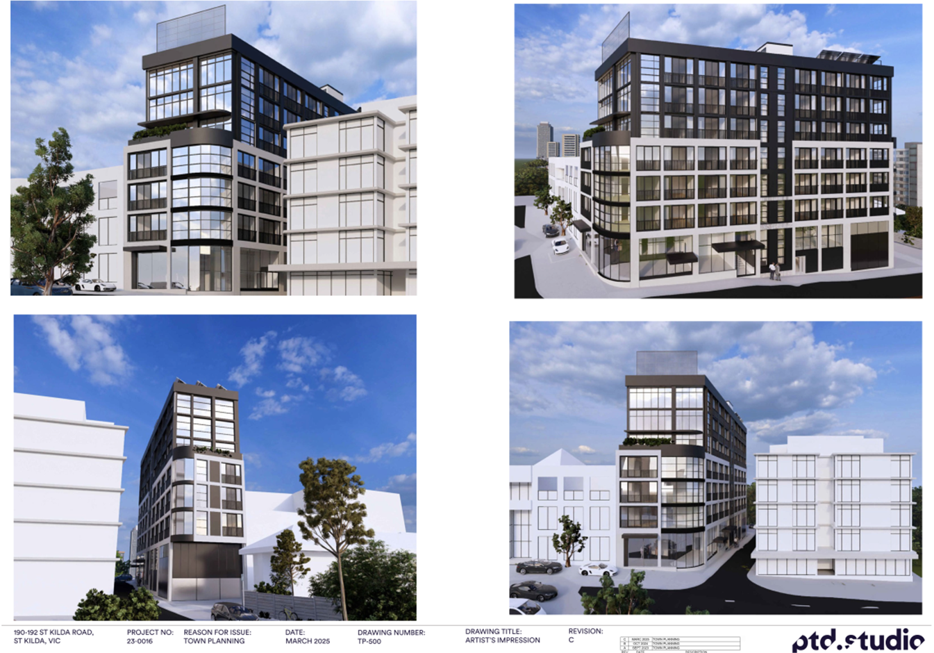
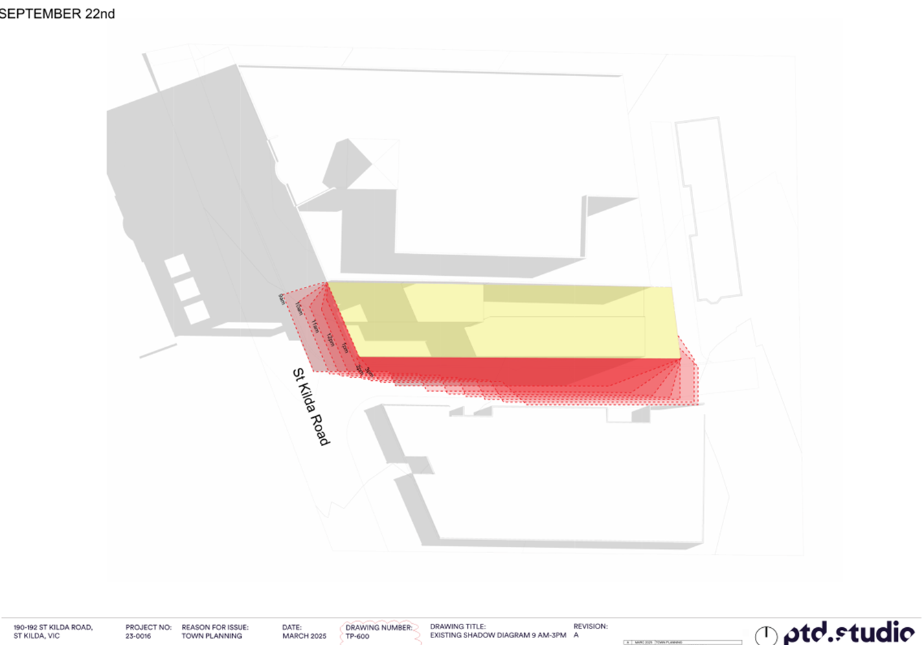
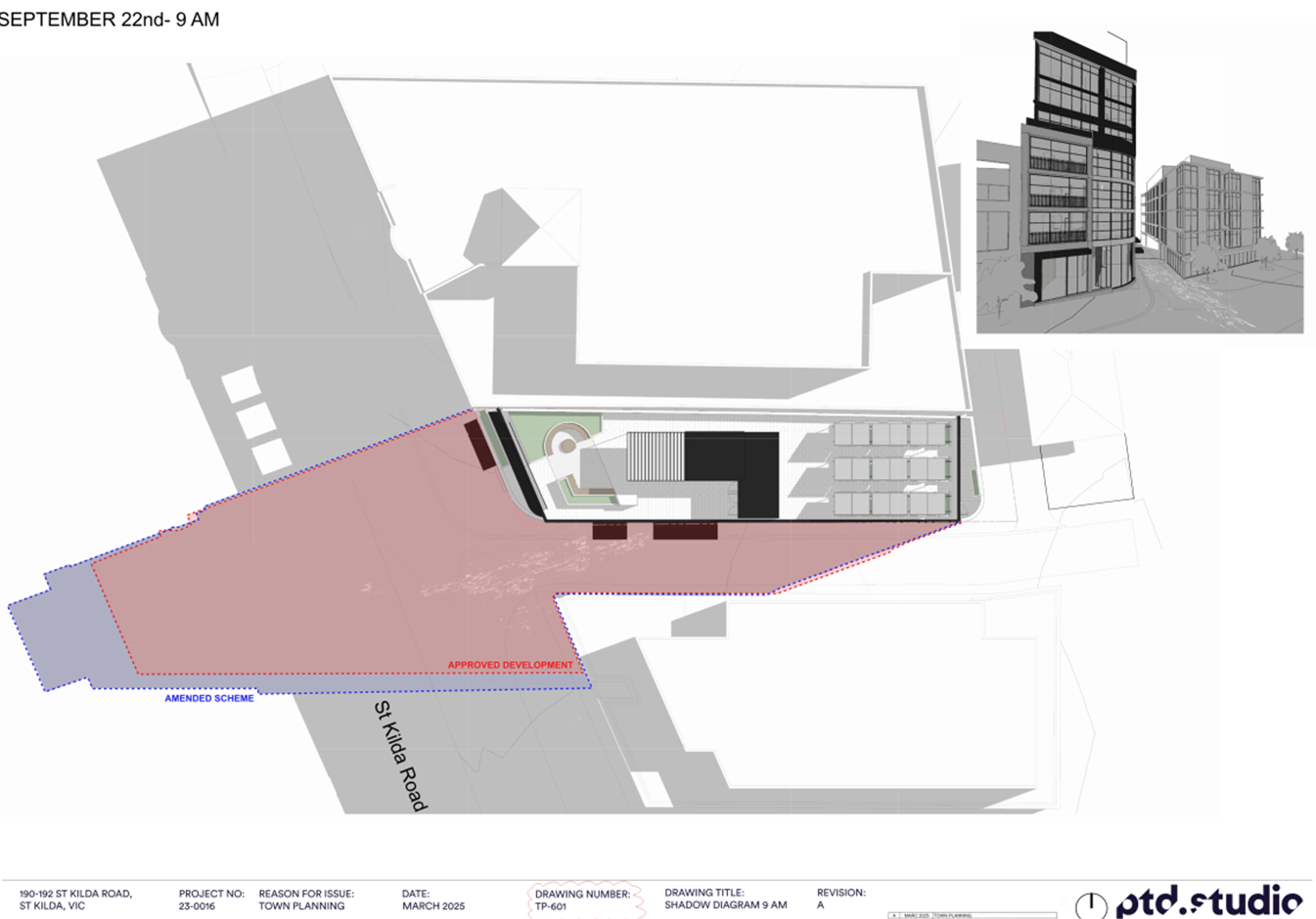
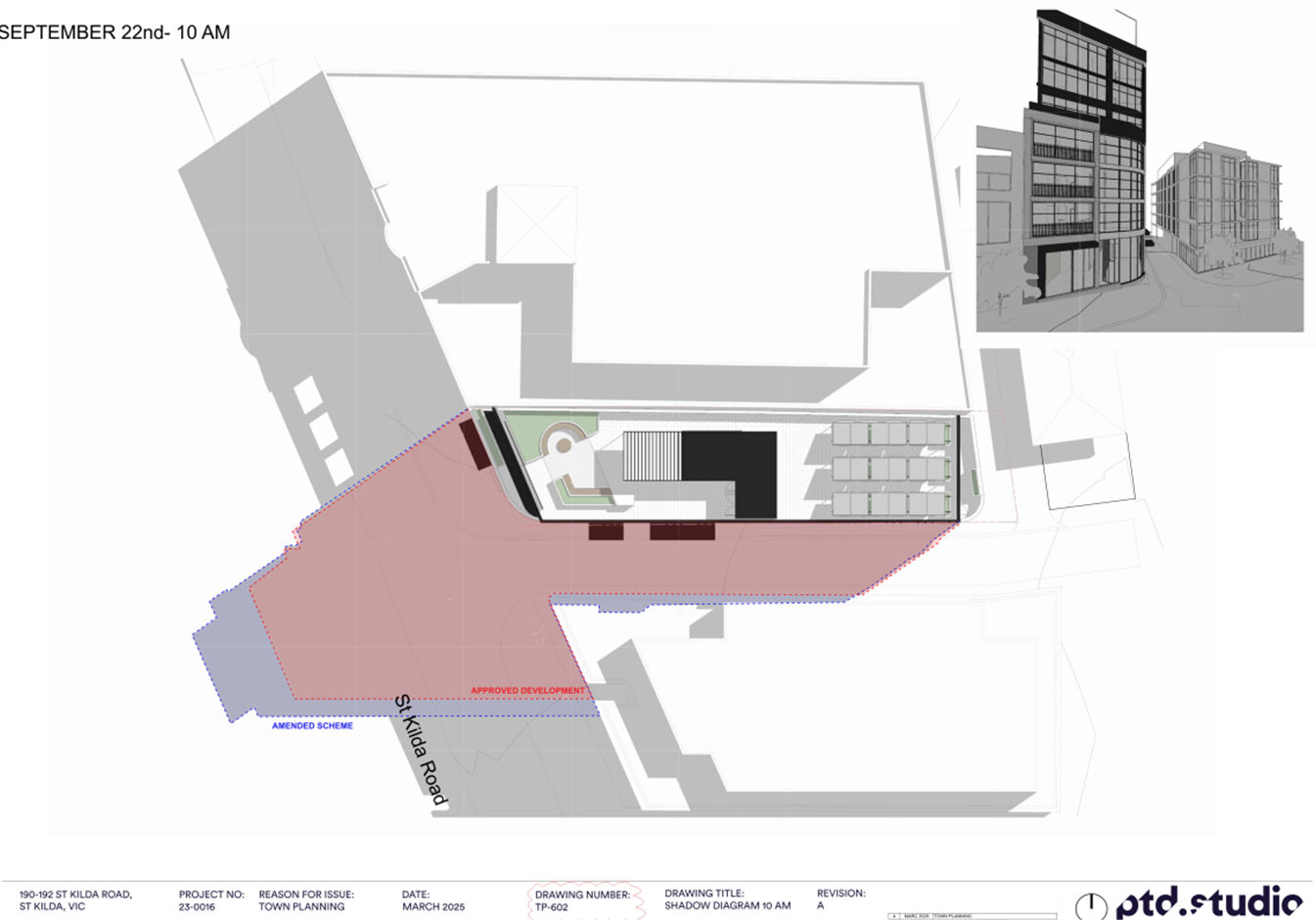
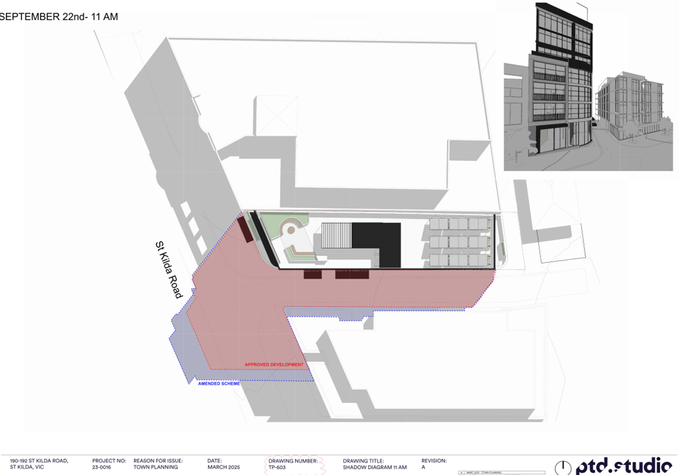
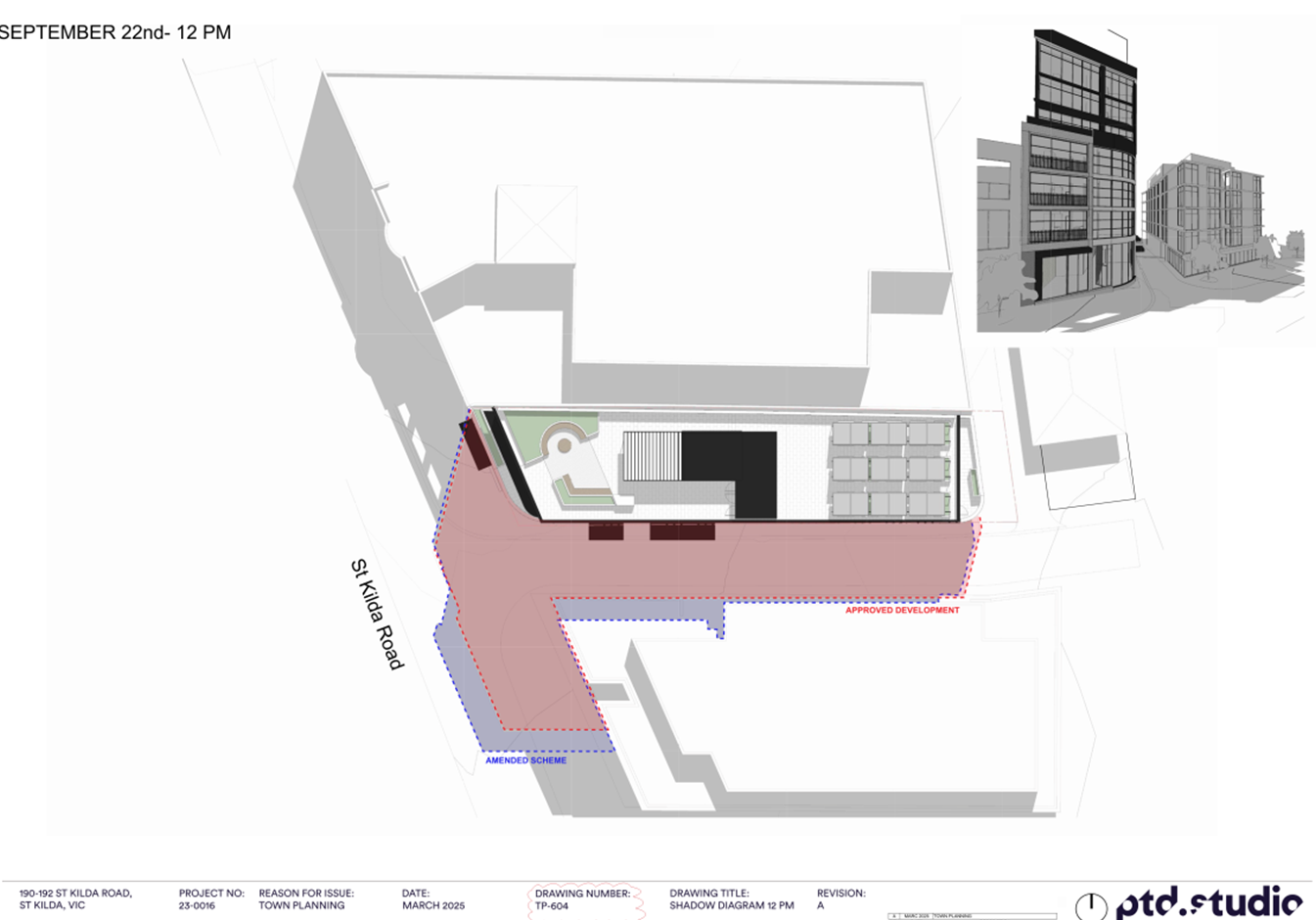
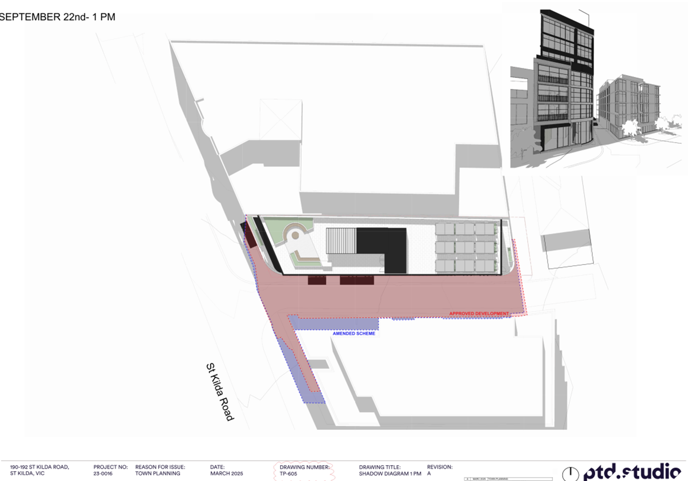
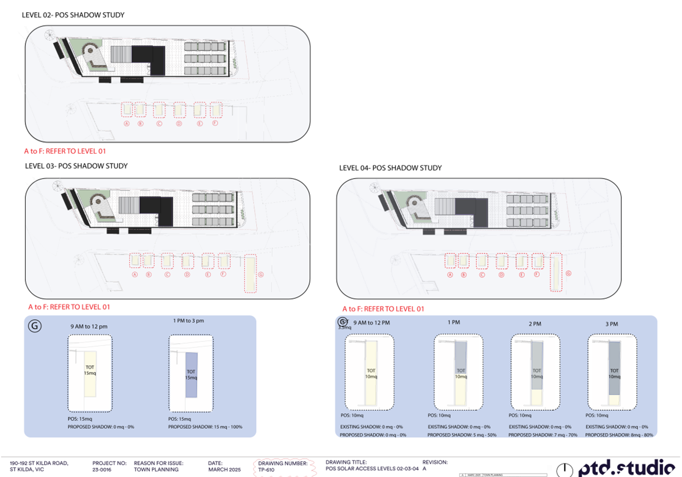
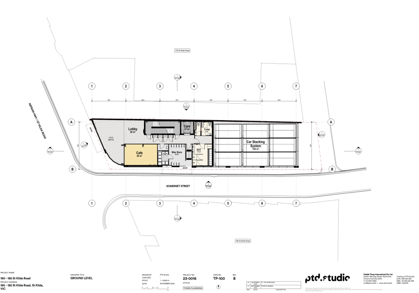
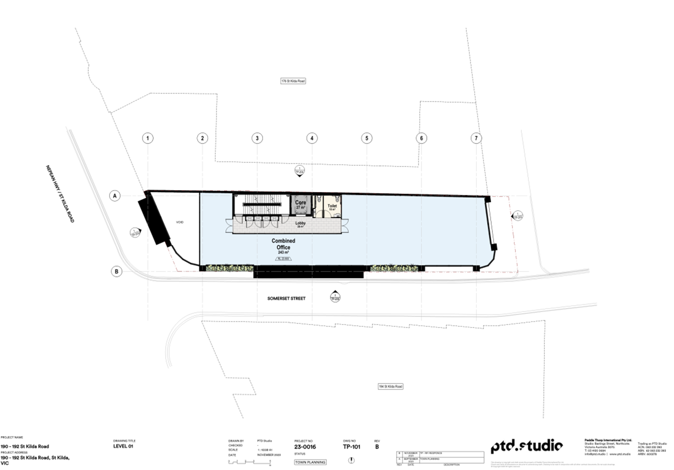
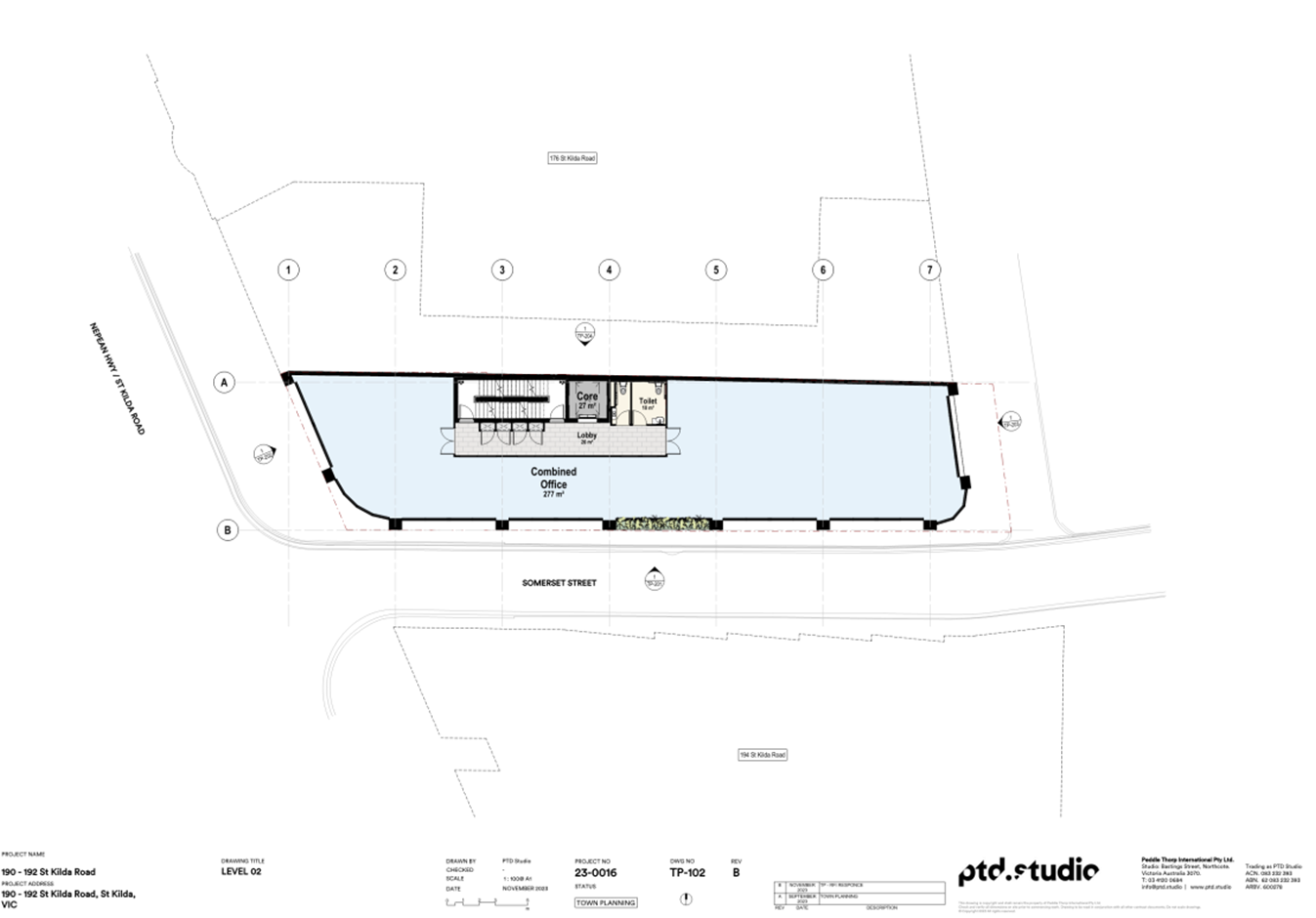
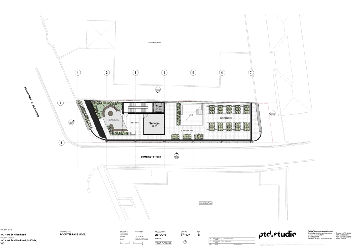
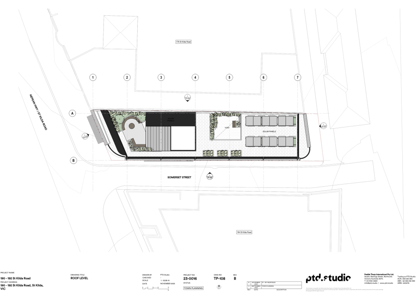
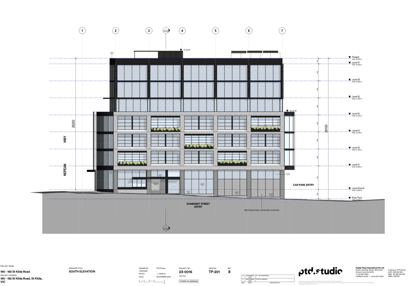
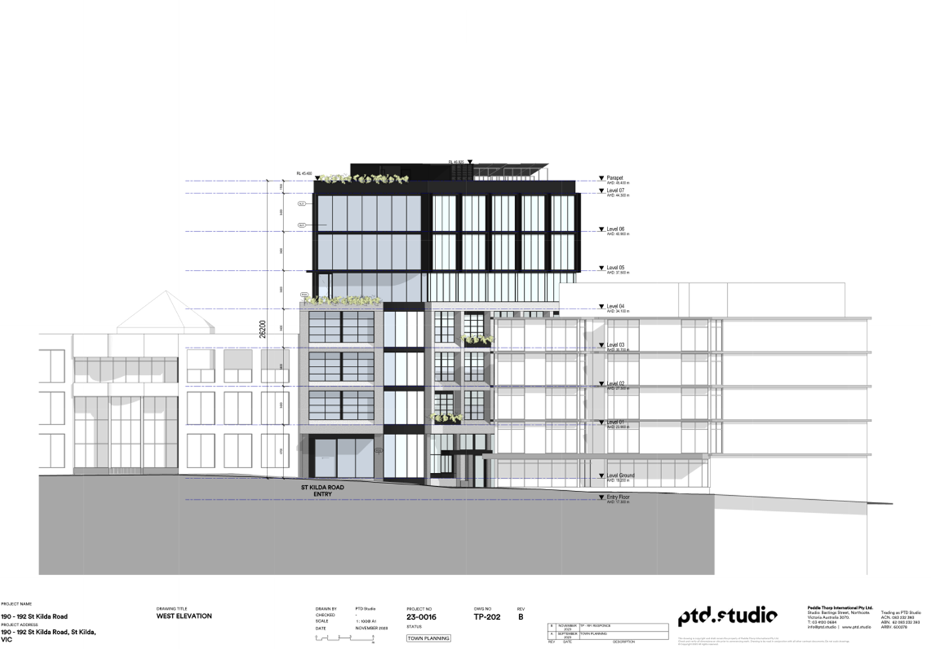
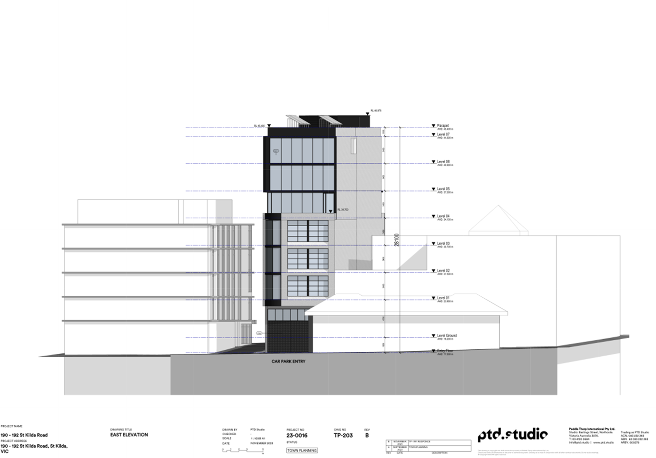
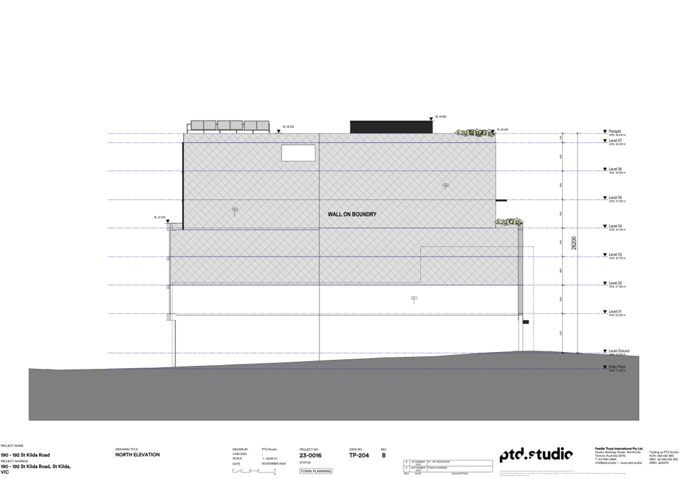
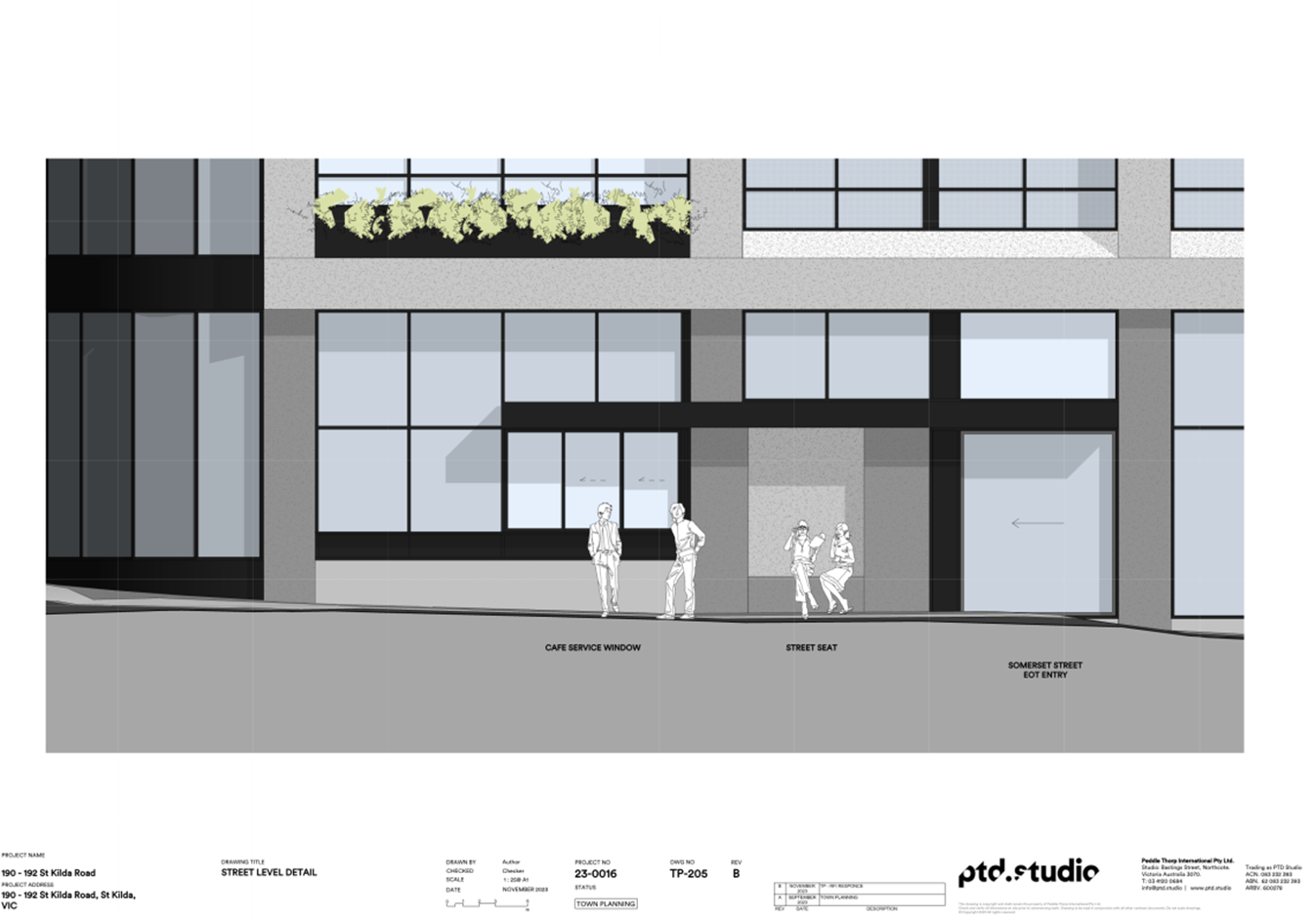
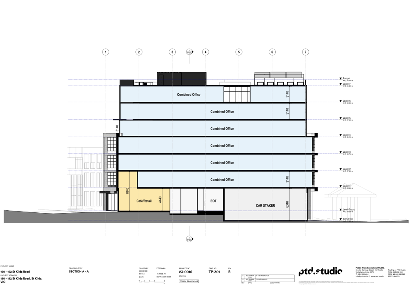
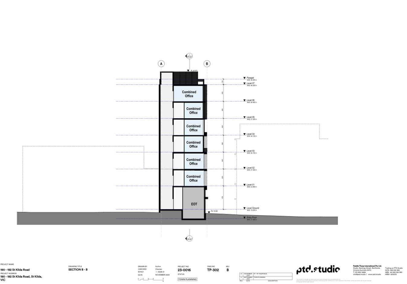
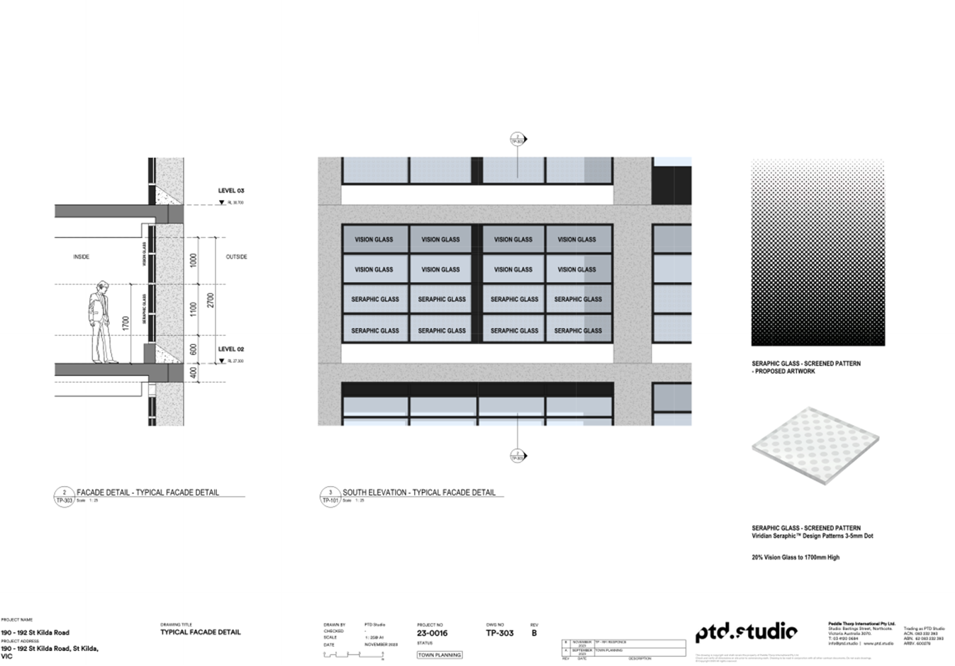
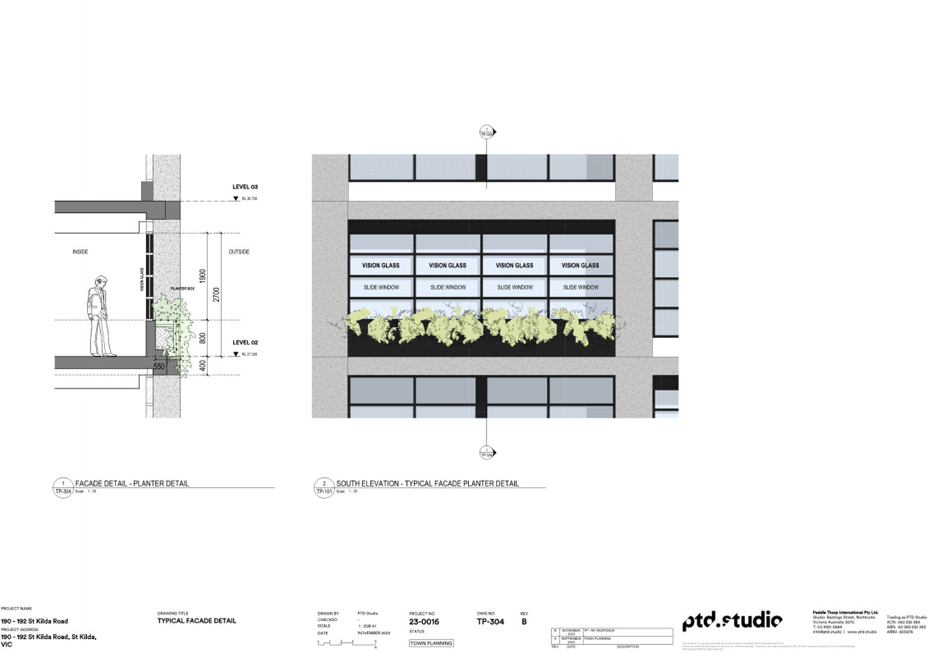
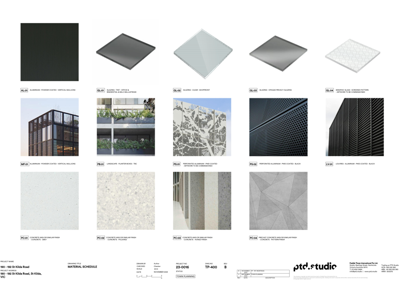
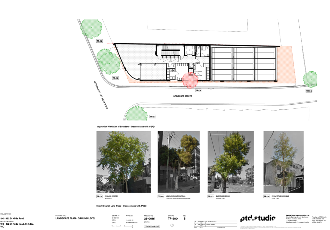
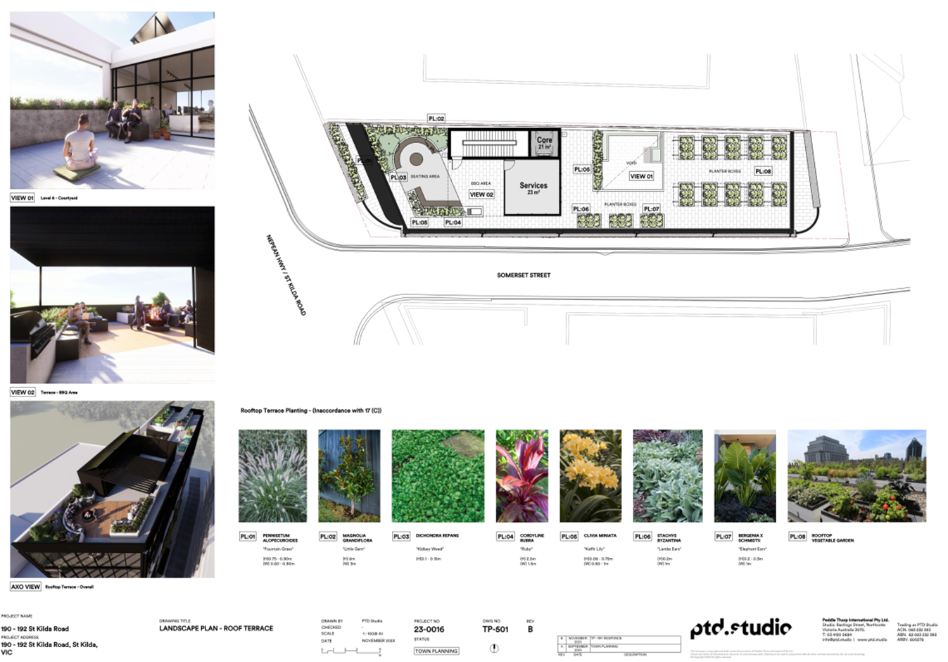
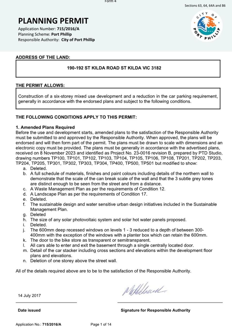
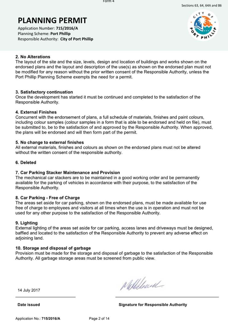
10.3 190 St Kilda Road, St Kilda - 715/2016/B................ 232
10.4 Submission to Victoria’s draft 30-year infrastructure strategy..................................................................... 337
11 Sustainable Port Phillip
11.1 Flood Modelling Technical Updates......................... 393
11.2 Community Electric Vehicle Charging Program....... 401
12 Vibrant Port Phillip
Nil
13 Well Governed Port Phillip
13.1 Existing use rights associated with the International Society for Krishna Consciousness (ISKCON) Temple at 197-205 Danks Street Albert Park........................ 417
13.2 Council Advisory Committee Review Update........... 424
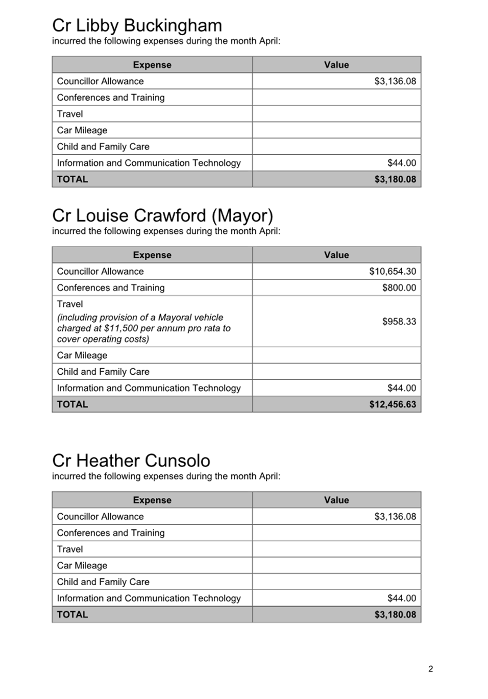
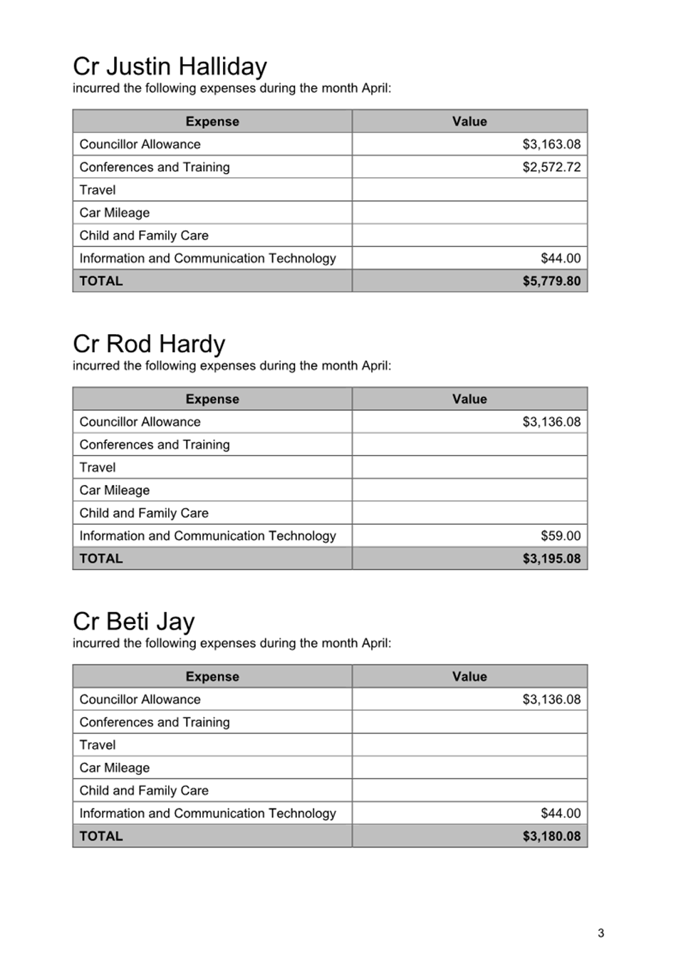
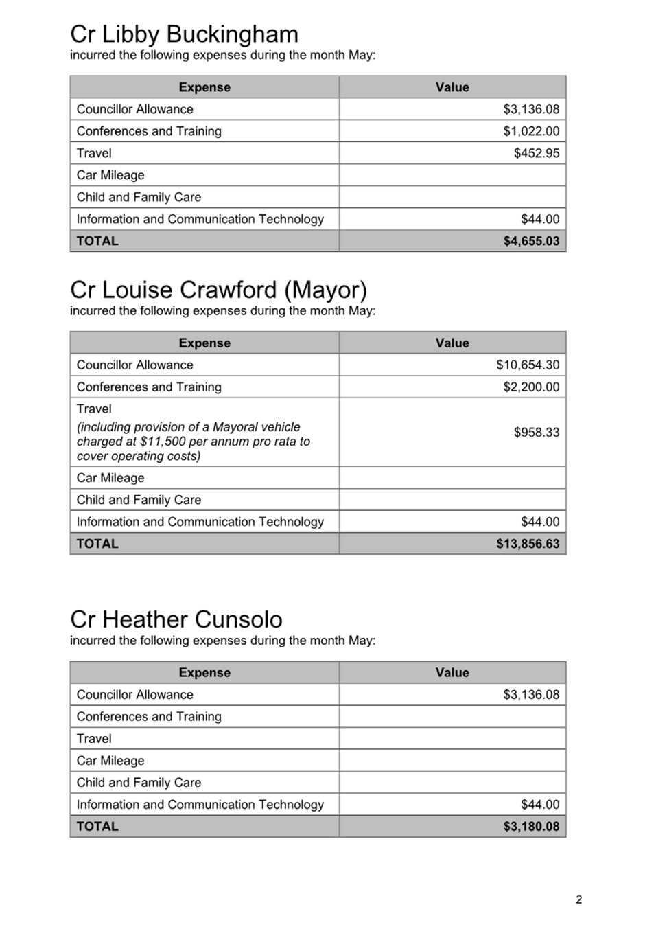
13.3 Councillor Expenses Monthly Reporting - April and May 2025.................................................................. 442
14 Notices of Motion
Nil
15 Reports by Councillor Delegates
16 URGENT BUSINESS
17 Confidential Matters…………………………………………………………..…446
The information contained in the following Council reports is considered to be Confidential Information in accordance with Section 3 of the Local Government Act 2020.
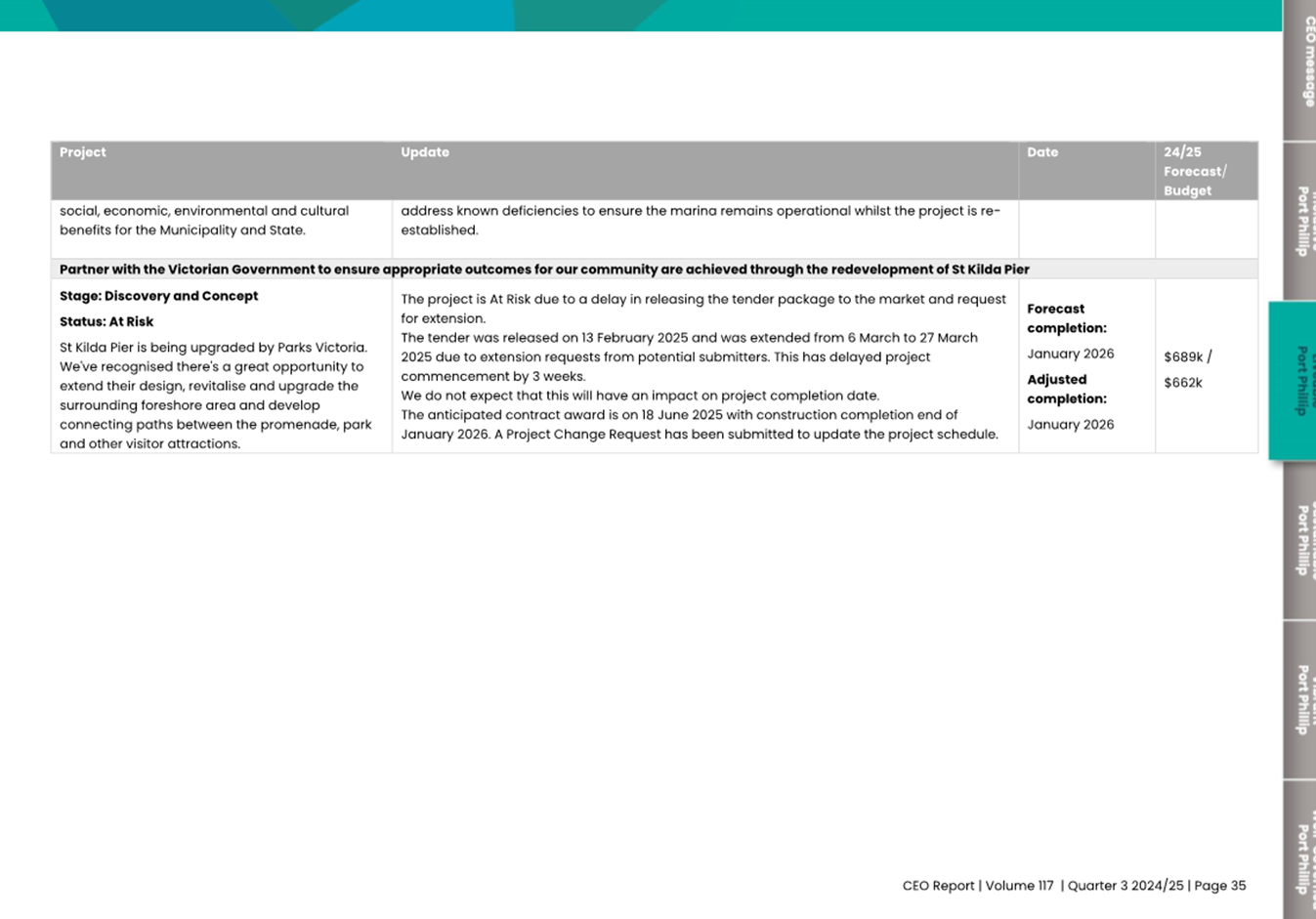
17.1 St Kilda Pier Landside Works Upgrade - Contract Award
3(1)(g(ii)). private commercial information, being information provided by a business, commercial or financial undertaking that if released, would unreasonably expose the business, commercial or financial undertaking to disadvantage.
Reason: This report contains the assessment and recommendation arising from a confidential procurement process. Further, the report outlines options available to address a budget shortfall. The costings of these options are commercial in confidence. Disclosure of this information publicly may impact Council's ability to work with the recommended contractor in the delivery of the project.
17.2 Delivered Meals Contract Extension Report
3(1)(g(ii)). private commercial information, being information provided by a business, commercial or financial undertaking that if released, would unreasonably expose the business, commercial or financial undertaking to disadvantage.
Reason: The report contains specific information regarding the current contract spend, and contractor performance which would unreasonably expose the business.
1. Apologies
2. Minutes of Previous Meetings
|
That the minutes of the Meeting of the Port Phillip City Council held on 21 May 2025 be confirmed. |
3. Declarations of Conflicts of Interest
4. Public Question Time and Submissions
5. Councillor Question Time
6. Sealing Schedule
Nil
7. Petitions and Joint Letters
7.1 Petition: Woodgate Street and Boundary Street Lighting................................................................ 5
7.2 Petition: Enhancing Argyle Street Precinct......... 7
7.3 Petition: Urban Forest Precinct Plan................. 12
Meeting of the Port Phillip City Council
18 June 2025
|
Petition: Woodgate Street and Boundary Street Lighting |
A Petition containing 91 signatures, was received from residents of Woodgate Street and Boundary Street.
The Petition states the following:
To the Mayor and Councillors of the Port Phillip City Council
The Petition of the following named citizens draws the attention of the Council that sections of the street between Woodgate Street and Boundary Street remains poorly lit, especially during the evening and nighttime hours. The lack of proper lighting poses significant safety risks for Port Melbourne and Fishermans Bend residents, pedestrians, cyclists, and motorists who regularly use this street.
Key Concerns include:
· Safety Hazards: The current lighting does not provide sufficient visibility, increasing the risk of accidents, falls, and other incidents. This is particularly concerning for elderly residents, children, and those walking or cycling along the street at night.
· Increased Vulnerability: The insufficient lighting creates dark spots, making the area more susceptible to criminal activity, and causing residents and visitors to feel unsafe.
· Impact on the Community: As our community continues to grow and attract more visitors, it is vital that our infrastructure evolves accordingly to ensure the safety and well-being of all who live in, work in, and visit the area.
The following Petitioners hereby request the installation of additional streetlights in the affected area. We firmly believe that addressing these issues is crucial to maintaining a safe, vibrant, and welcoming neighbourhood for all.
OFFICER COMMENT
Officers acknowledge receipt of the petition and thank those that have prepared the petition and garnered the interest of concerned residents. Officers understand the concerns, recognising the importance of appropriate public lighting to uphold public safety, accident prevention, and deter criminal and other unsavoury activities. Officers are familiar with this area and have undertaken past investigations and responded to concerns raised by residents.
There are gaps in the public lighting network around South Melbourne; similar gaps exist in Port Melbourne and Fishermans Bend. These gaps exist where there has been a shift over the years in precinct use away from industrial / commercial and to residential. This shift in precinct use has resulted in greater levels of service required in terms of public lighting, and the streetlights in Woodgate Street (Boundary to Montague Street) fall into this category.
Scheduled for FY 2025/26, a municipal wide assessment of the public lighting network will take place. Public lighting requirements will form part of this work and will inform the funding requirements for a multi-year upgrade and renewal program of public lighting.
In the interim, arrangements will be made for the temporary deployment of a lighting solution to improve the current situation, and the pruning of trees to address shading issues impacting lighting performance.
|
That Council: 1. Receives and notes the Petition. 2. Thanks the petitioners for their Petition relating to street lighting between Woodgate and Boundary Streets, South Melbourne. 3. Directs the CEO, or their delegate, to arrange for the temporary deployment of a lighting solution to improve the current situation, and the pruning of trees to address shading issues impacting lighting performance. 4. Provides a response at a future Council meeting, informed by the municipal wide assessment of the public lighting network. |
|
ATTACHMENTS |
Nil |
Meeting of the Port Phillip City Council
18 June 2025
|
7.2 |
Petition: Enhancing Argyle Street Precinct |
A Petition containing 19 signatures was received from residents of Alma Ward, Albert Park Ward & City of Port Phillip
The Petition states the following:
We, the undersigned residents and stakeholders, thank the City of Port Phillip for initiating the Enhancing Argyle Street Precinct project and for the opportunity to contribute to the future planning of our neighbourhood. This project presents a rare and valuable chance to future-proof Argyle Street and its surrounds for the next 60+ years, delivering safer, greener, and more accessible public infrastructure for all community members.
In the spirit of collaboration, we submit this petition to provide resident feedback and input for inclusion of specific design elements to ensure the initiative reflects the lived experiences, aspirations, and long-standing advocacy of local residents. Our requests are based on more than 15-20+ years of community consultation, ongoing engagement, and repeated submissions made to Council since 2010.
1. ROAD RESURFACING & TRAFFIC CALMING
We request:
a) Road Resurfacing
· Full resurfacing of Argyle Street and key adjoining streets including:
o Marriott Street
o Steele Avenue
o Henryville Street
o Odessa Street
o Lambelth Place
b) Removal of Old Existing Speed Humps
· Remove all outdated brick-top speed humps.
c) Traffic Calming Measures - examples only:
Safer Protected Pedestrian Crossings with Garden Beds
· Install new flat-top road humps (75mm height), modelled on City of Monash design: https://shape.monash.vic.gov.au/valley-haughton
· Painted pedestrian crossings and kerb extensions with garden beds
· Benefits: reduced vehicle speed, better visibility, lower noise, improved aesthetics and pedestrian safety
Strong Objection:
No Watts Profile Humps
Watts Profile speed humps are strongly opposed by residents and community members due to their multiple drawbacks:
· Excessively noisy, especially when speeding vehicles, or heavy vehicles such as garbage trucks or delivery vans pass over them, disrupting nearby homes at all hours.
· Ineffective for traffic calming: many drivers do not anticipate their steepness, brake suddenly upon approach, then accelerate rapidly afterward to regain momentum encouraging erratic and unsafe driving patterns between humps.
· Increase wear and tear on vehicles, especially low-clearance cars, and pose challenges for emergency services and public transport vehicles that require smoother road transitions.
· Aesthetic blights, often appearing as harsh, intrusive additions to residential streetscapes that reduce visual amenity.
· Prioritise pedestrian safety, failing to include flat-top or painted pedestrian zones which improve visibility and safe crossing, especially for children, older residents, and people with disabilities.
No Use of Bricks
Bricks become slippery and deteriorate quickly; we oppose any use on crossings or footpaths, foot paths or pedestrian crossings (ie do NOT use bricks).
2. FOOTPATH UPGRADES - WIDENING, ACCESSIBILITY, SAFETY
We request Council:
a) Undertake comprehensive footpath works:
· Fully resurface, widen, and level footpaths along Argyle Street and adjoining streets
· Eliminate trip hazards and steep crossovers where possible
· Use consistent, non-slip surface materials
· Install accessible kerb ramps and safe pedestrian zones
b) Prioritise safety and access for vulnerable users:
· Elderly residents, disability aid users, prams, and young families
· Visitors to Betty Day Community Centre and St Kilda Kindergarten
· Social housing residents and business patrons
c) Proposal:
· Fully upgrade the northern footpath of Argyle Street (St Kilda Rd to Chapel St), and Southern footpath if able
· Provide at least one continuous, safe, compliant pedestrian corridor
3. TREE PLANTING, CANOPY & GREENING STRATEGY
Generally we're very support the proposal for landscaping and planting, but not sure it goes far enough for meeting councils 30% green canopy targets, and kindly request under Council's greening and sustainability objectives:
· Install new garden beds along verges and traffic calming locations
· Include rain gardens at all street corners- refer to note on utilities and services
· Plant more mature tree stock (where possible), not saplings, for accelerating canopy benefits
· Replace underperforming or inappropriate existing trees with new species for uniformity
· Odessa St corner- Replace new tree with Ulmus Parvifolia and plant garden bed
· Ensure alignment with 30% canopy coverage target from the Urban Forest Strategy: https://www.portphillip.vic.gov.au/media/ifnh3rzr/urban-forest-strategy_2024.pdf
4. ALIGNMENT WITH URBAN FOREST PRECINCT PLAN (UFPP)
Council is urged to apply relevant tools from the Urban Forest Precinct Planning Guidelines: https://haveyoursay.portphillip.vic.gov.au/greening-port-phillip-1
Design features requested include:
· Protected pedestrian crossing
· Localised lane narrowing - perhaps used instead of installing new speed humps/pedestrian crossings?
· Corner build-out
· Footpath Widening
· Kerb outstands (within road)
5. UTILITIES - DO NOT LET UTILITY SERVICES BLOCK GOOD DESIGN
We ask Council to:
· Work proactively with utility providers (gas, water, NBN, electricity) to relocate assets or adopt workarounds
· Learn from previous successful projects within CoPP
· Explore co-funding or planning exemptions where required
6. BETTY DAY CENTRE &JIM DUGGAN RESERVE PRECINCT MASTERPLAN
The precinct offers a once-in-a-generation opportunity. We urge the City to accelerate funding commit to a comprehensive, integrated masterplan, design and construction.
We request:
· A fast tracked investment of $10-20M+ to future-proof community facilities, for master plan, design, construction of precinct
· Clear separation between temporary beautification works and permanent infrastructure upgrades
· Reallocation of funds from pop-up or cosmetic works toward strategic redevelopment works
Suggested Masterplan Elements:
· Create new north facing open space park with main entrance onto Argyle Street
· Relocate centre entrances to Marriott Street for better orientation & demolish existing buildings and relocate new buildings to southern section of site
· Upgraded childcare and kindergarten facilities
· Community café and social enterprise venue
· Shared community and co-working spaces
· Expanded Jim Duggan Reserve: gardens, basketball courts, BBQs
· EV charging stations, solar infrastructure, and green building design
· Relocate parking drop off/pick up zone from Argyle Street to Bath Street (rear of precinct), and/or construct underground parking to align with new entrances to future new kinder garden and betty care centre from Bath Street and Marriott Sts.
CONCLUSION
We respectfully request that the City of Port Phillip petition with:
· A formal written response
· Revised designs and actions incorporating resident feedback
· Funding and Timeline commitments for key works
· Confirmation of alignment with UFPP and Greening Port Phillip targets
This petition is made in good faith to ensure that this vital precinct reflects the needs, values, and aspirations of its community for the next generation and beyond
Kind Regards,
Residents of Alma Ward, Albert Park Ward & City of Port Phillip
OFFICER COMMENT
The feedback in the petition relates primarily to Council’s current ‘Enhancing Argyle Street Precinct’ project which was open for community feedback via Council’s online Have Your Say platform from 17 April until 22 May 2025.
The draft plan presented to the community for engagement was the result of a process to respond to community advocacy, primarily from the Safer Greener Argyle Street community group. The group which was established in 2023 and advocated for improvements to Argyle Street between St Kilda Road and Chapel Street, together with broader precinct upgrades. The lead petitioner is a founding member of the Safer Greener Argyle Street community group, and several petitioners are also members of the group. The group wanted to see improvements to footpaths and crossings, slower car speeds and less ‘rat running’, increased greening in kerb outstands and improved road surface and drainage.
Officers met with the group’s representatives to discuss ideas for improved amenity and safety on Argyle Street through the process of developing the draft plan. The plan outlines a draft vision, principles, and short-, medium- and longer-term outcomes. The document responds to residents by demonstrating opportunities to deliver tangible improvement to the area, guided by good urban design, and aligned to Council’s strategies and programs.
The Safer Greener Argyle Street community group was invited to gather and provide feedback on the draft document in January 2024. This feedback informed the updated draft which was recently shared online with the broader community to ensure the broader community as well as the community advocacy group could have their say.
To promote the engagement, approximately 320 letters were hand delivered by officers to residents of Argyle St and surrounding streets. There were also posters and left flyers at the Betty Day centre and the childcare centre.
The online engagement included survey questions and open fields for comments. Survey was filled out online by 51 people. Five survey responses referred to the petition. In addition to the survey and petition, one other detailed submission was received via email.
Officers are collating community feedback into an engagement summary report which will inform the final Enhancing Argyle Street Precinct plan.
Officers will include the feedback from the petition into the broader community feedback received via Have Your Say to ensure there is a complete assessment of community sentiment. This will assist in developing a clear picture of community views, enable a transparent and wholistic evaluation of feedback, balancing competing views to inform the final plan and other next steps.
Detailed design will quickly follow confirmation of the final plan in order to prepare for delivery in 2025/26. $990k is allocated for delivery of these works.
|
That Council: 1. Receives and notes the petition. 2. Thanks the petitioners for their petition. 3. As this petition pertains to an operational matter, in accordance with Council’s Governance Rules, Council refers the petition to the CEO for consideration. 4. Notes that Council has recently completed community engagement on proposed improvements to Argyle Street, which were instigated in response to community advocacy. 5. Notes that the feedback received via the petition will be included and responded to as part of the community engagement process. |
|
ATTACHMENTS |
Nil |
Meeting of the Port Phillip City Council
18 June 2025
|
7.3 |
Petition: Urban Forest Precinct Plan |
A Petition containing 26 signatures, was received from the residents of Alma Ward, Albert Park Ward and the City of Port Phillip.
The Petition states the following:
We, the undersigned residents and community members, formally request that the City of Port Phillip urgently include the area bounded by St Kilda Road-Inkerman Street - Chapel Street- Dandenong Road within the current planning phase of the Urban Forest Precinct Plan. This area is a vital civic, transport, residential and mixed-use corridor that has been excluded from the current draft, despite its strategic importance and alignment with Council's stated objectives. If required, the construction and implementation can be delivered in stages _ however, we urge Council to ensure the planning phase fully incorporates this precinct now, to avoid inefficiencies and lost opportunities.
PLANNING PHASE- “Must Include" Zone
St Kilda Rd-Inkerman St-Chapel St -Dandenong Rd Area
Integrate into current planning phase to align delivery and avoid duplicated costs
KEY REASONS FOR INCLUSION
1. Planning & Budget Efficiency
· Prevents fragmented rollout and duplicated ramp-up/ramp-down delivery costs.
· Optimises timeline for budgeting, design, and construction.
· Reduces long-term project management delays and risk.
2. Integrated Urban Outcomes
· Transport & Safety: This area is a critical connector across tram, pedestrian, cycling, and vehicle routes.
· Public Realm Activation: Unlocks public benefit for surrounding community and commercial areas.
· Canopy & Cooling: Current hard surface ratio + limited green space = priority heat island mitigation zone.
· Green Network Logic: Seamlessly links to adjacent Urban Forest precincts.
3. Maximising Council Resources
· Enables holistic community consultation and delivery.
· Strategic, forward-thinking planning delivers far greater ratepayer value.
· Supports long-term, sustainable infrastructure outcomes.
DELIVERY / CONSTRUCTION PHASE
We raise no objection to this area being delivered in future stages. However, it must be included in the current planning to ensure strategic alignment and future delivery
efficiency.
We ask Council to:
1. Acknowledge this petition.
2. Confirm inclusion of this zone in the current planning phase.
3. Update the public consultation map and link to reflect inclusion.
|
That Council: 1. Receives and notes the Petition and provides a response as part of the ‘Balaclava & East St Kilda Urban Forest Precinct Plan’ report being considered at a future Council meeting. |
|
ATTACHMENTS |
Nil |
Meeting of the Port Phillip City Council
18 June 2025
8.1 Presentation of CEO Report Issue 117 - Quarter 3, and CEO Report Issue 118 - April, 2024-25. 16
Meeting of the Port Phillip City Council
18 June 2025
|
Presentation of CEO Report Issue 117 - Quarter 3, and CEO Report Issue 118 - April, 2024-25 |
|
|
Executive Member: |
Robyn Borley, Director, Governance and Organisational Performance |
|
PREPARED BY: |
Kihm Isaac, Corporate Planning and Performance Advisor |
1. PURPOSE
1.1 To provide Council with a regular update from the Chief Executive Officer regarding Council’s activities and performance.
2. EXECUTIVE Summary
2.1 In March 2014, the City of Port Phillip introduced a program of more regular performance reporting through the CEO Report.
2.2 The attached CEO Report – Issue 117 (Attachment 1) focuses on Council’s performance for Quarter 3 (January to March) 2024/25.
2.3 Issue 117 was deferred from the 21 May Council Meeting.
2.4 The attached CEO Report – Issue 118 (Attachment 2) focuses on Council’s performance for April.
|
That Council: 3.1 Notes the CEO Report – Issue 117 (provided as Attachment 1). 3.2 Notes the CEO Report – Issue 118 (provided as Attachment 2). 3.3 Authorises the CEO or their delegate to make minor editorial amendments that do not substantially alter the content of the report. |
4. OFFICER MATERIAL OR GENERAL INTEREST
4.1 No officers involved in the preparation of this report have a material or general interest in the matter.
|
ATTACHMENTS |
1. CEO Report Issue 117 Third Quarter 2. CEO Report Issue 118 - April |
Meeting of the Port Phillip City Council
18 June 2025
9.1 Older Persons Advisory Committee Annual Report 2024 - For Endorsement..................... 121
Meeting of the Port Phillip City Council
18 June 2025
|
Older Persons Advisory Committee Annual Report 2024 - For Endorsement |
|
|
Executive Member: |
Kylie Bennetts, General Manager, Community Wellbeing and Inclusion |
|
PREPARED BY: |
Simone Jamieson, Team Leader Community Building |
1. PURPOSE
1.1 To present the Older Persons Advisory Committee (OPAC) Annual Report (Attachment 1) for the period January to December 2024.
2. EXECUTIVE Summary
2.1 The OPAC Annual Report 2024 documents activity of the Committee, including membership, meetings, subcommittees and working groups, significant consultation and feedback activity, as well as engagement with external groups and events.
2.2 OPAC was established in 2000 as an outcome of the International Year of the Older Person and is the peak advisory and advocacy body on issues affecting the wellbeing of older people (55 years and over) in Port Phillip. OPAC provides advice to Council on policies, plans and services and encourages Council to advocate to other levels of government, for significant events, activities and services.
2.3 OPAC aims to be representative and advocate on behalf of older persons from Port Phillip’s diverse community including people with disabilities, people who identify as lesbian, gay, bisexual, transgender, or intersex (LGBTI), people of Aboriginal or Torres Strait Island background, people experiencing financial disadvantage (including people who are homeless or at risk of homelessness) and multicultural and multifaith communities.
|
That Council: 3.1 Acknowledges the value of the work undertaken by the Older Persons Advisory Committee as the peak advisory and advocacy body on issues affecting the wellbeing of older people (55 years and over) within the City of Port Phillip. 3.2 Notes the Older Persons Advisory Committee Annual Report 2024 (Attachment 1) 3.3 Thanks the members of the Older Persons Advisory Committee for their contribution, and for their generosity in sharing their knowledge and lived experience to improve the lives of older people in Port Phillip. |
4. KEY POINTS/ISSUES
Key achievements for 2024
4.1 OPAC were consulted and provided feedback on the Positive Ageing Policy Implementation Plan, Council Caretaker and Election Period, Engagement for the Community Safety Plan, South Melbourne Structure Plan and the Housing Strategy Phase 3.
4.2 Via a budget submission from the OPAC there was an increase in digital literacy programs and equipment through the Port Phillip Library Service.
4.3 The OPAC successfully advocated to extend the existing Advisory Committees into the Council Term to provide experience and support for the new Council Plan and Budget.
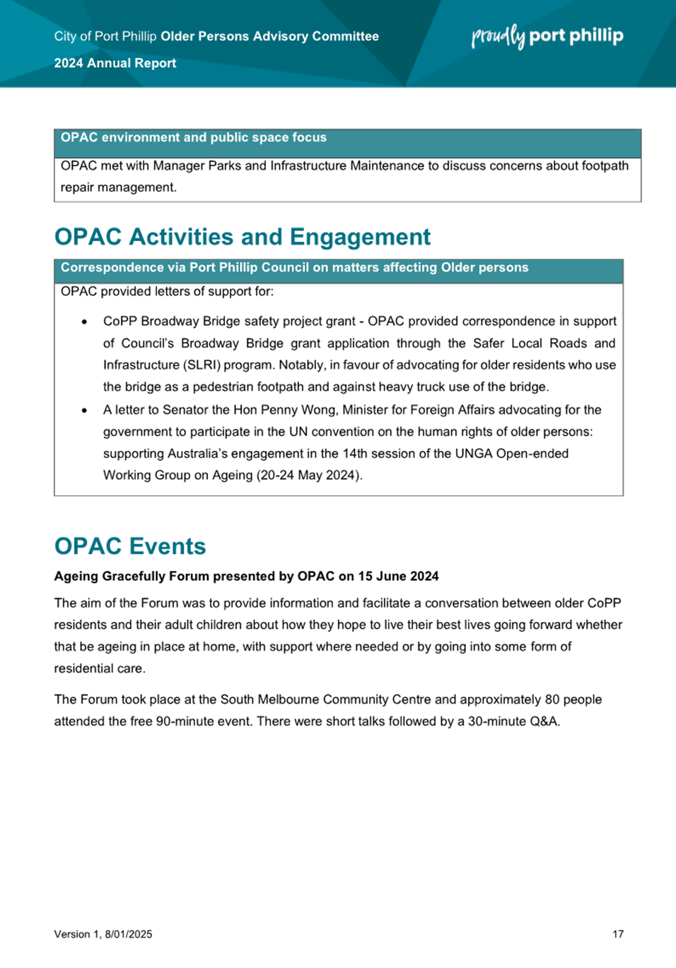
4.4 The OPAC held a positive ageing forum titled ‘Ageing Gracefully in Port Phillip’ in June 2024 on the topic of ageing in place.
4.5 The OPAC met with officers involved in the St Kilda Festival and Live Local to advocate for an increase in programming suited to older residents. As a result of this advocacy additional performances have been delivered during the weekday and during daylight hours.
Highlighted lived experience information provided to Council
4.6 The OPAC supported Council with their concern of the closure of the Blessington Street Post Office and the impact on older residents.
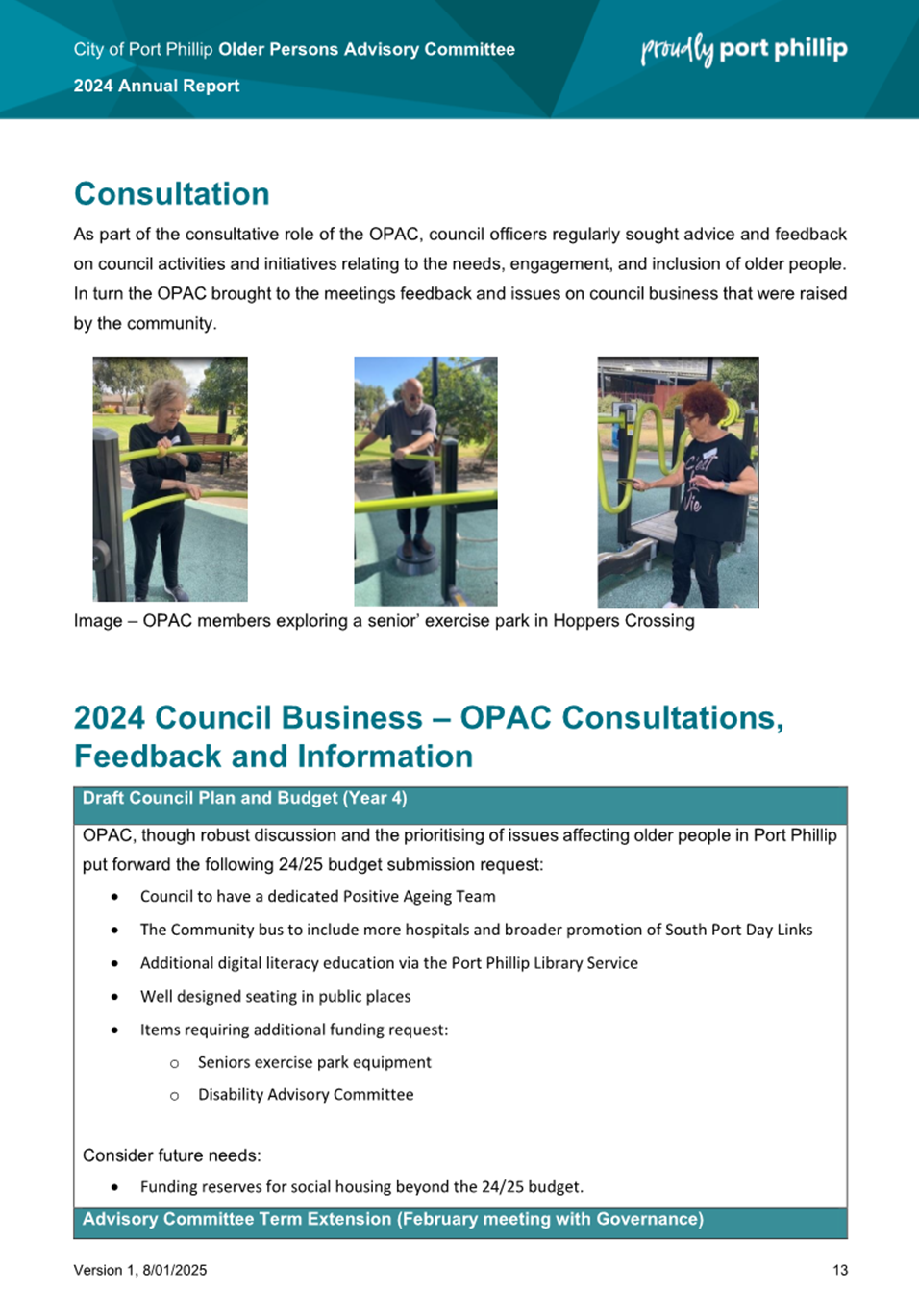
4.7 The OPAC worked with Sport and Recreation to proactively seek physical activity opportunities for older residents during the weekday and during daylight hours.
4.8 The OPAC met with the Transport Team to promote bike use amongst older residents and supported the provision o bicycle education sessions.
4.9 The OPAC met with the Communications Team to provide feedback on the Council Website useability.
4.10 OPAC met with Parks and Infrastructure Maintenance to discuss concerns about footpath repair management affecting older people.
OPAC Election of Office Bearers
4.11 At the OPAC March 2024 meeting Wendy Priddle was re-elected as Chair and Ian MacDonald was re-elected as Deputy Chair.
Membership and Recruitment
4.12 Throughout 2024, the OPAC membership remained unchanged at 16 consistent members.
OPAC Activities and Engagement with External Groups and Organisations
4.13 The OPAC provided correspondence in support of Council’s Broadway Bridge grant application through the Safer Local Roads and Infrastructure (SLRI) program.
4.14 The OPAC provided a letter of support for a letter to Senator the Hon Penny Wong, Minister for Foreign Affairs advocating for the Federal Government to participate in the UN Convention on the Human Rights of Older Persons.
OPAC Events 2024
4.15 The OPAC reactivated their community forum (after a hiatus during the COVID pandemic) and delivered a 90-minute information and conversation session at the South Melbourne Community Centre in June 2024.
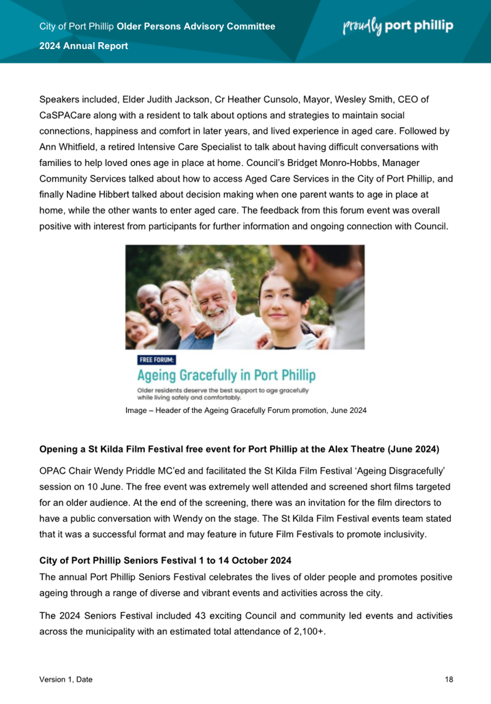
4.16 The OPAC
co-designed the 2024 City of Port Phillip Seniors Festival, held from
1 to 15 October. The festival included 43 Council and community led
events and activities with an estimated total attendance of over 2,100
people. Acts and activities included an 80s tribute show to launch the
Festival, sport and recreation activities, community gardening, digital
storytelling and art workshops, safety forums and healthy living seminars,
cultural celebrations and concluded with the annual Seniors Festival Writing
Awards celebrating literary works of older people.
OPAC Governance – Development of Action Plan
4.18 The OPAC developed the OPAC Annual Plan which included associated actions for 2024.
4.19 The OPAC Governance Subcommittee was established in 2020 to support the OPAC to develop guidelines and processes to ensure OPAC meetings run effectively and efficiently. Where appropriate it has a role in implementing decisions taken by OPAC.
4.20 In 2024 the Governance Subcommittee utilised the following tools to assist with its stated aim of efficient and effective operations:
· OPAC Governance Sub Committee Guidelines
· Guidelines for the establishment of OPAC Working Group and Sub-Committees
· Agenda setting and meeting procedures
· Consultation guidelines for council officers
· Process for introducing New Items for action by OPAC
· Procedure for Subcommittees and Working Groups.
5. CONSULTATION AND STAKEHOLDERS
5.1 The 2024 Annual Report was informed by input from the OPAC Chairperson Wendy Priddle and Deputy Chairperson Ian MacDonald, and with input from committee members Freda Erlich, Coralie Ling, Sue McGowan, Neville Aphoy, Judith Armstrong, Betty Knight, Rosemary Rule, Liz Robson, Kevin English, Richard Whitfield, Ada Lubin, Jeanette Lyons, Janet Gardner, and Vasileios Tsialtas.
6. LEGAL AND RISK IMPLICATIONS
6.1 There are no known legal or risk implications.
7. FINANCIAL IMPACT
7.1 The budget allocation for the OPAC program for the financial year is $4,700. Approximately 0.3 FTE supports the activities of this Committee.
7.2 The OPAC are Port Phillip residents who provide their time and skills on a voluntary basis.
8. ENVIRONMENTAL IMPACT
8.1 The OPAC are committed to sustainability ensuring all catering provisions for monthly meetings adhere to Council’s sustainability guidelines.
8.2 Printing is kept to a minimum with most communication by email.
9. COMMUNITY IMPACT
9.1 The OPAC provides the opportunity for understanding good governance, community and civic participation and sharing of best practice to advocate for older people in the Port Phillip community.
9.2 The OPAC is a formal advisory group to Council. In 2024, sixteen local residents/committee members participated on a voluntary basis.
9.3 In 2024 the OPAC provided feedback on a range of significant projects, plans and services.
9.4 OPAC members represented the following associations/networks and reported relevant activities at the OPAC monthly meetings; Elwood Croquet Club, Bicycle Users Group, Port Phillip Citizens for Reconciliation, University of the Third Age Port Phillip, Port Phillip Multifaith Network, Port Phillip Multicultural Advisory Committee, Linking Neighbours Leadership Group.
10. ALIGNMENT TO COUNCIL PLAN AND COUNCIL POLICY
10.1 Since 2000, the Older Persons Advisory Committee has been guided by and aligned to the strategic goals of each Council Plan.
10.2 The activities of this committee align with two of the Strategic Directions in the 2021-31 Council Plan:
Strategic Direction 1 – Inclusive Port Phillip, Initiatives:
We will provide client services and programs that are inclusive and accessible for all, including people who identify as LGBTIQA+, people with disability, people from culturally and linguistically diverse backgrounds, Indigenous backgrounds, and people experiencing homelessness.
We will partner with our Older Persons Advisory Committee, Youth Advisory Committee, Multicultural Advisory Committee, MultiFaith Network and establish other committees, where relevant, to ensure the diversity of our community’s experience is represented in decision-making.
Strategic Direction 5 – Well Governed Port Phillip, Initiatives:
We will provide opportunities for our community to participate in civic life and help share Council policy, services, programs, and decisions by facilitating engagement in line with Council’s Community Engagement Policy.
10.3 The OPAC Annual Report in 2024 documents OPAC’s ongoing support of the Council’s Positive Ageing Policy. Members of the OPAC are key subject matter experts and provide advice on the ongoing implementation of the attached plan to the Positive Ageing Policy.
11. IMPLEMENTATION STRATEGY
11.1 TIMELINE
11.1.1 The OPAC Annual Report will be presented to members at the June 2025 OPAC Meeting.
11.2 COMMUNICATION
11.2.1 The OPAC 2024 Annual Report will be made available to the community on the Council website including in an accessible version format.
12. OFFICER MATERIAL OR GENERAL INTEREST
12.1 No officers involved in the preparation of this report has declared a material or general interest in the matter.
|
ATTACHMENTS |
1. OPAC Annual Report 2024 |
Meeting of the Port Phillip City Council
18 June 2025
10.1 St Kilda Botanical Gardens Public Toilets Design & Construction................................................. 147
10.2 Edwards Park Public Amenities Location....... 210
10.3 190 St Kilda Road, St Kilda - 715/2016/B....... 226
10.4 Submission to Victoria’s draft 30-year infrastructure strategy...................................... 332
Meeting of the Port Phillip City Council
18 June 2025
|
St Kilda Botanical Gardens Public Toilets Design & Construction |
|
|
Executive Member: |
Lachlan Johnson, General Manager, Operations and Infrastructure |
|
PREPARED BY: |
Vicki Tuchtan, Manager Property and Assets Kimberley Ingram, Divisional Project Portfolio Manager Golpooneh Rahimlabaf Zadeh, Project Manager |
1. PURPOSE
1.1 To present the Engagement Summary Report (refer Attachment 1) arising from the community engagement on the new proposed public toilets for the St Kilda Botanical Gardens.
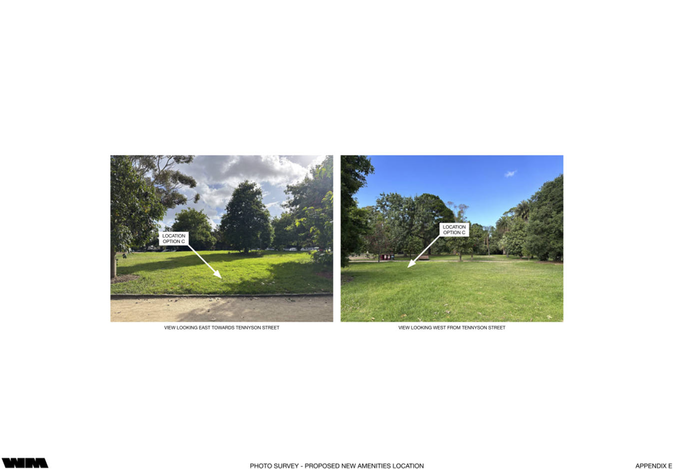
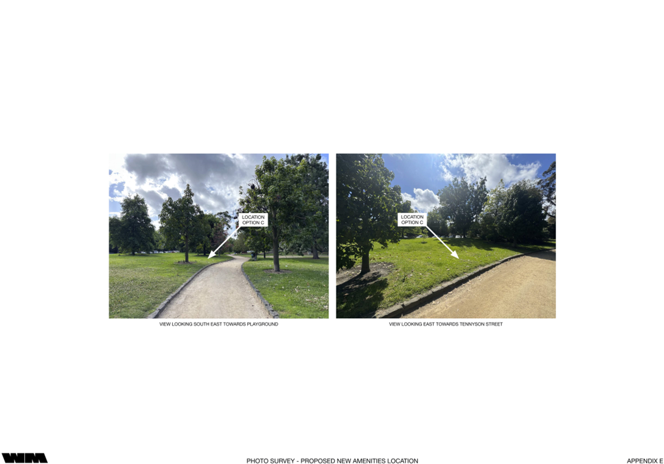
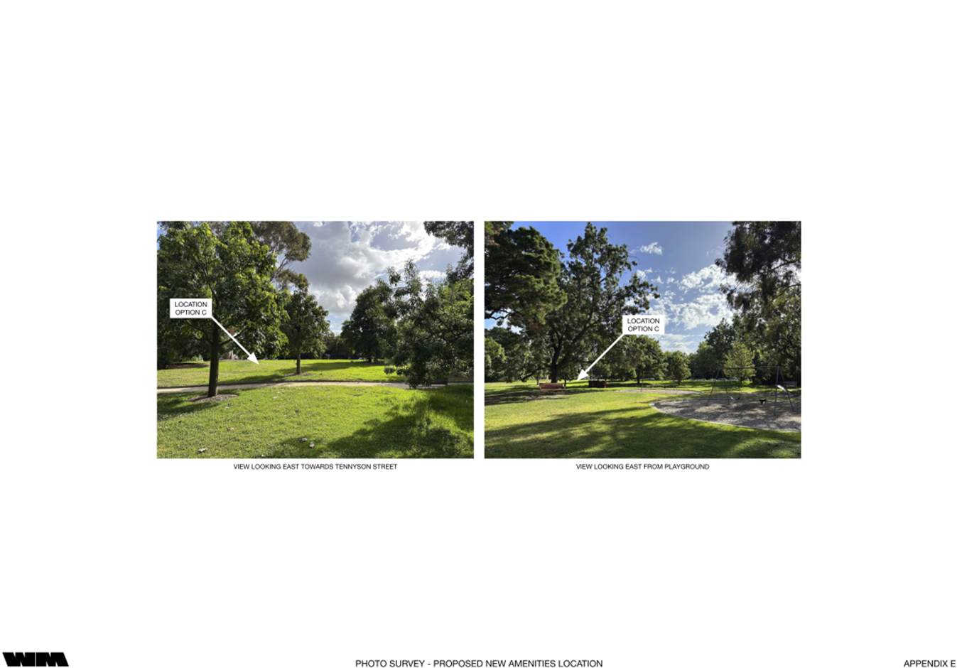
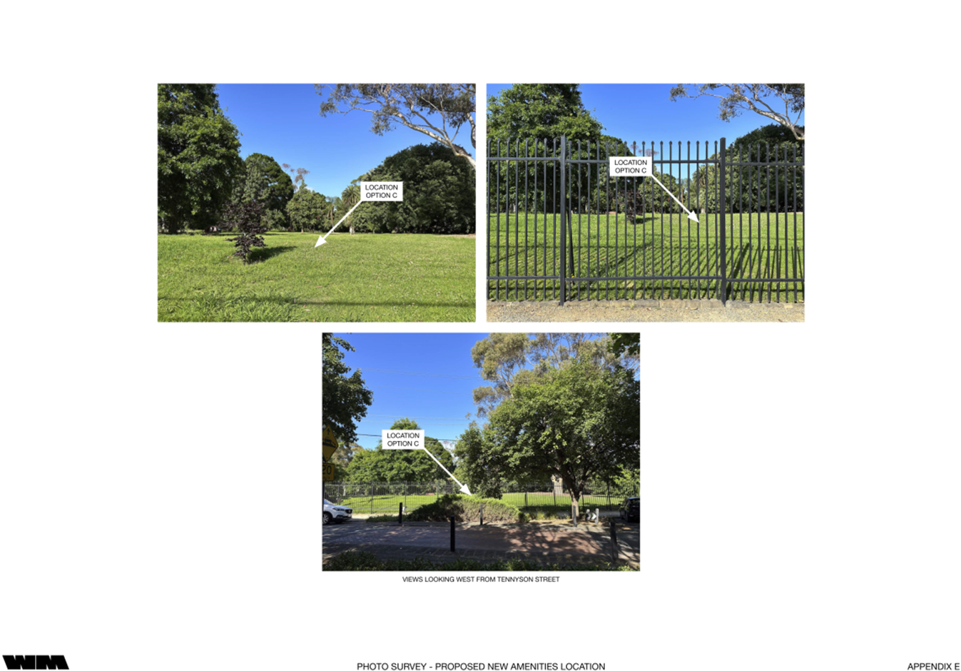
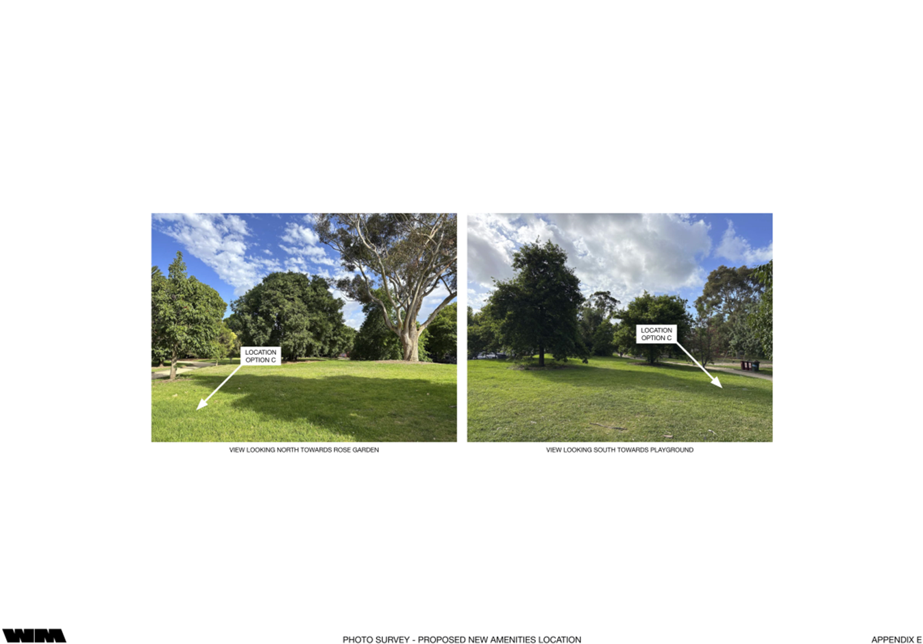
1.2 To recommend Council proceed to the design stage at a preferred location in the Southeast quadrant, near the children’s playground, and adjacent Tennyson Street.
2. EXECUTIVE Summary
2.1 The St Kilda Botanical Gardens are highly utilised, heritage listed gardens.
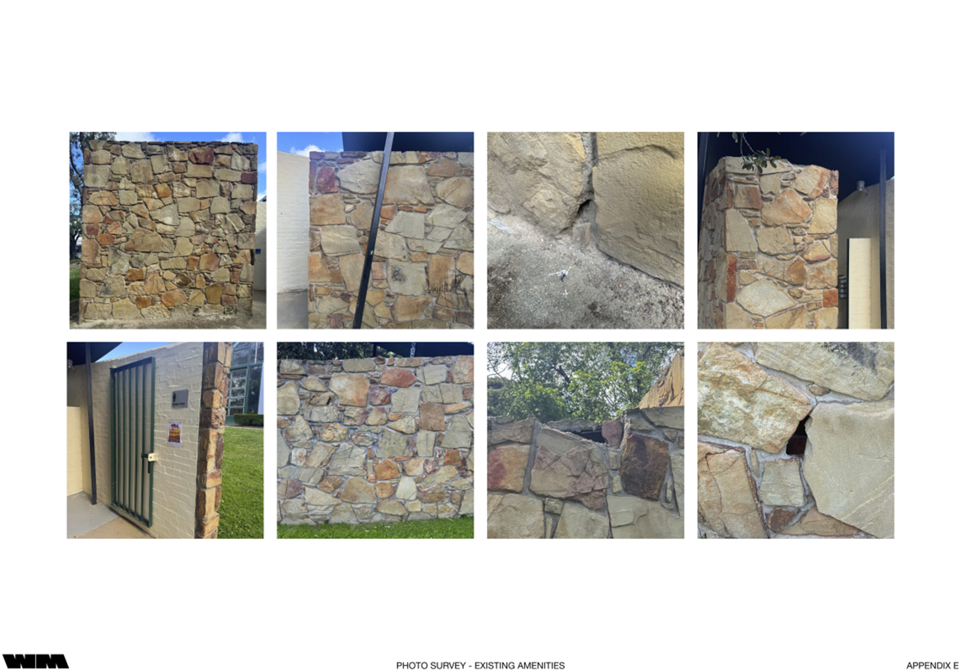
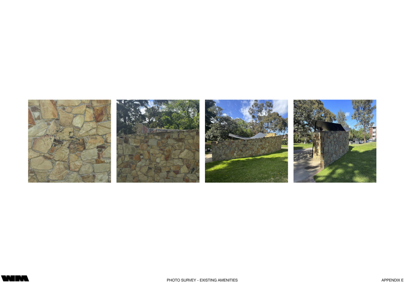
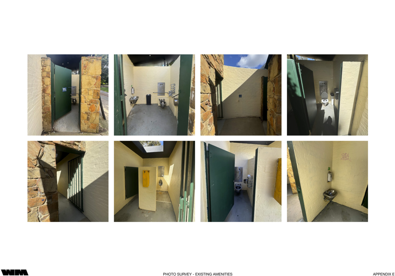
2.2 Public amenities designed by the architecture firm Wood Marsh in 1993 exist and contain five (5) toilets, including one accessible toilet. However, these facilities do not comply with current Disability Discrimination Act 1992 (Cth) (DDA) standards.
2.3 The existing public amenities do not meet current capacity, and Council allocates funds annually for temporary toilet hire during busy periods, which are both unsightly and costly.
2.4 Council identified the need for major upgrades of the St Kilda Botanical Gardens facilities in its Public Toilet Plan 2023-2033.
2.5 As such, officers propose constructing an additional amenities block near the children’s playground to accommodate the demand for public amenities throughout the year.
2.6 The siting of new amenities near the children’s playground would address an identified issue that users of the playground are disproportionately far from the existing amenities compared to other key garden facilities.
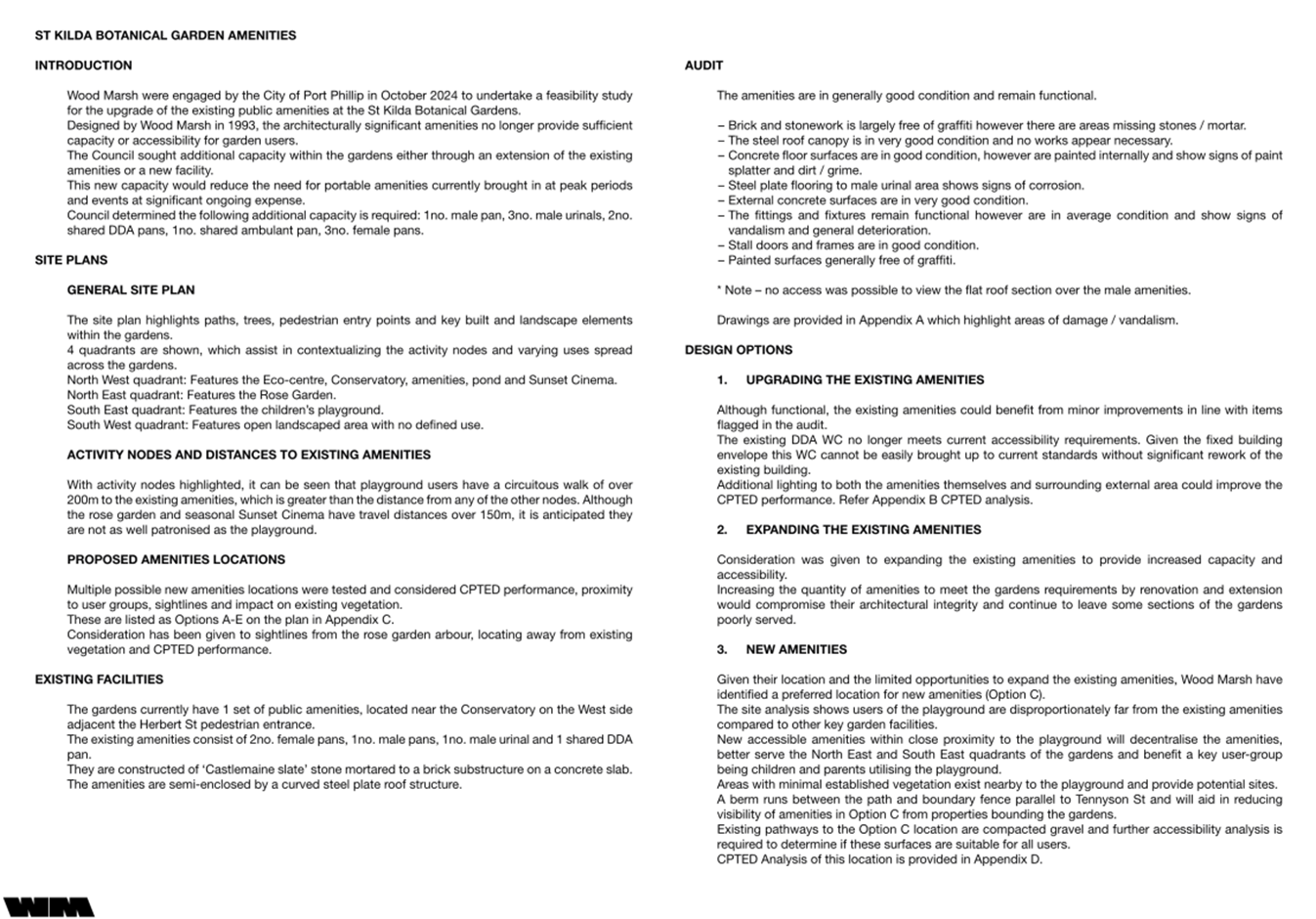
2.7 Wood Marsh were engaged by the City of Port Phillip in October 2024 to undertake a feasibility study for the upgrade or expansion of the existing public amenities, or the construction of a new facility, at the St Kilda Botanical Gardens (refer Attachment 2).
2.8 It was deemed that – due to design – any modification, whether upgrade or expansion, of the existing toilet block would impact its architectural integrity, particularly any changes aimed at accommodating a compliant DDA toilet.
2.9 Five (5) possible locations for new amenities have been considered.
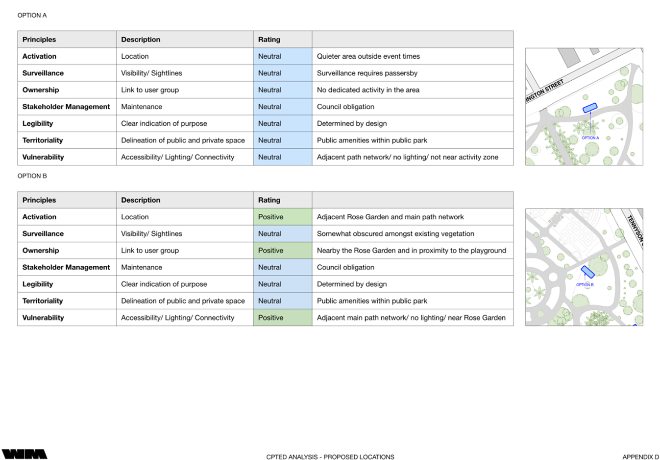
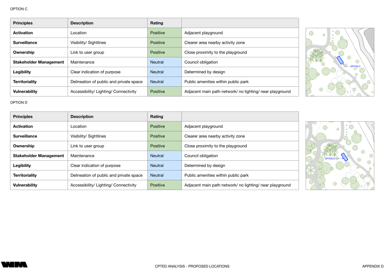
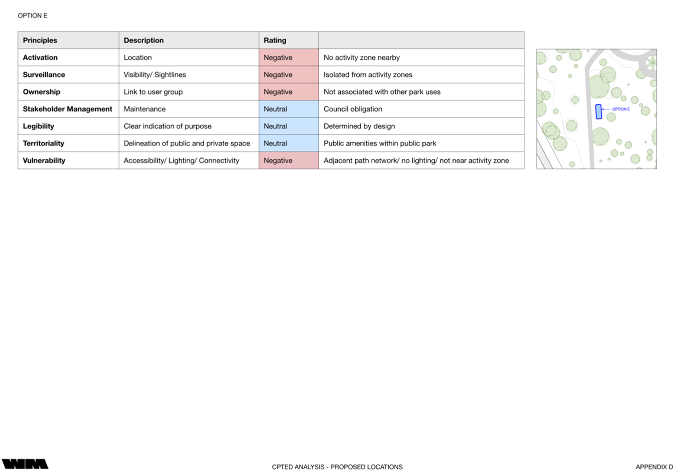
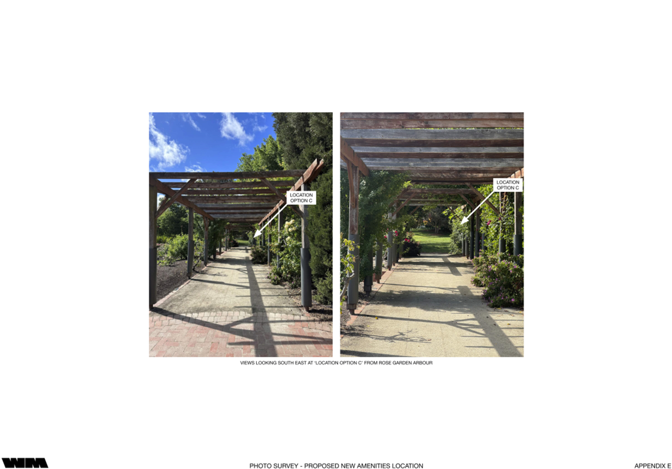
2.10 Wood Marsh have identified a preferred location (option C), which is near the children’s playground and rates highly in terms of Crime Prevention through Environmental Design (CPTED) principles, access, and service to the park.
2.11 Wood Marsh have stated that new accessible amenities at the preferred location within proximity to the playground will decentralise the amenities, better serve the Northeast and Southeast quadrants of the gardens and benefit a key user-group being children and parents utilising the playground.
2.12 Community engagement was held over a three-week period to gauge community feedback regarding the proposed new amenities. 67 responses were received, with a fairly even split between those in support or against the proposed project.
2.13 A concern for those against the project was the loss of open space and the addition of another building within the gardens.
2.14 Officers have considered the feedback received and evaluated what mitigation measures could address the concerns and recommend proceeding with the preferred location (option C).
|
That Council: 3.1 Thanks community members who have provided feedback on the proposed new public amenities within St Kilda Botanical Gardens. 3.2 Notes the Feasibility Study Report and Engagement Summary Report included as Attachments 1 and 2. 3.3 Endorses proceeding to the design stage at the preferred location (option C), in the Southeast quadrant, near the children’s playground, and adjacent Tennyson Street. |
4. KEY POINTS/ISSUES
4.1 The St Kilda Botanical Gardens are highly utilised, heritage listed gardens that attract many visitors each year, playing host to numerous events including weddings, parties, and outdoor cinema / theatre performances.
4.2 The gardens house a children’s playground, giant chessboard, ornamental pond, glasshouses, and Port Phillip EcoCentre, as well as seasonal displays, local indigenous plants, and a wide variety of bird and animal life, making the gardens well visited by a diverse range of visitors and locals.
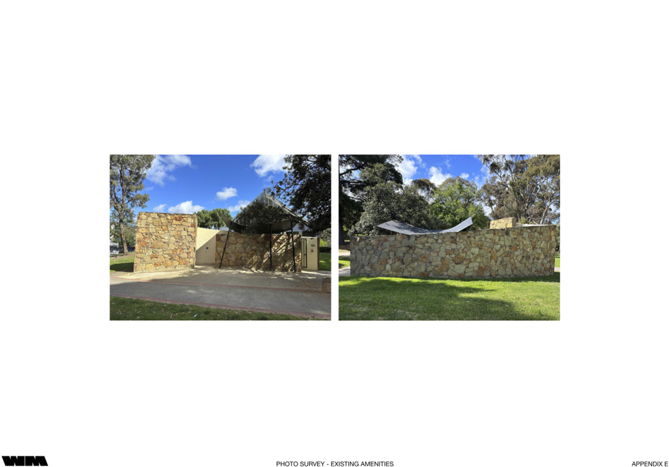
4.3 The current public amenities in the park were designed by the architecture firm Wood Marsh in 1993, who were the recipients of a Victorian design award.
4.4 The facilities are considered architecturally significant, however do not comply with current DDA standards.
4.5 Additionally, the existing public toilets do not provide sufficient capacity for garden users, with Council spending approximately $11,000 per annum (made up of ~$7,500 hire and ~$3,500 maintenance) on the provision of temporary toilets over the summer holiday period, when the park experiences peak usage.
4.6 When operational, the temporary amenities occupy an area of around 6m x 3m and provide the equivalent of seven additional toilets. They are located opposite the existing facilities, across the pathway towards the Southern end of the Gardens.
4.7 Whilst useful to address the capacity requirements, the temporary toilets are not pleasant to use and are considered an ‘eye-sore’ by gardens users.
4.8 In response to the increased capacity requirements and to incorporate a DDA compliant facility within the gardens, Council’s Public Toilet Plan 2023-2033 nominated additional amenities be constructed within the gardens, via the upgrade or expansion of the existing public amenities, or the construction of a new facility.
4.9 Due to their history with the gardens and previous design of the existing amenities, officers engaged Wood Marsh to undertake a feasibility study.
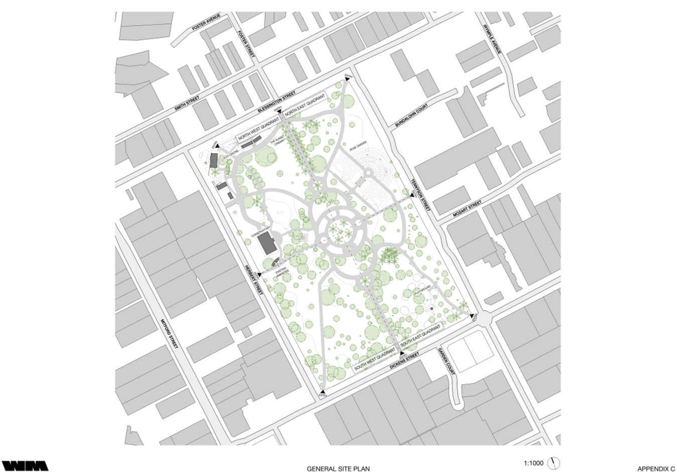
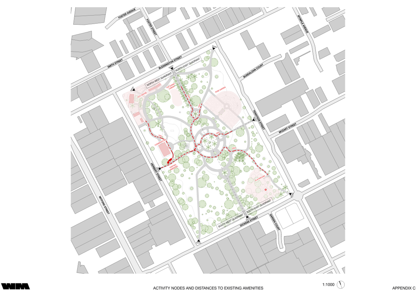
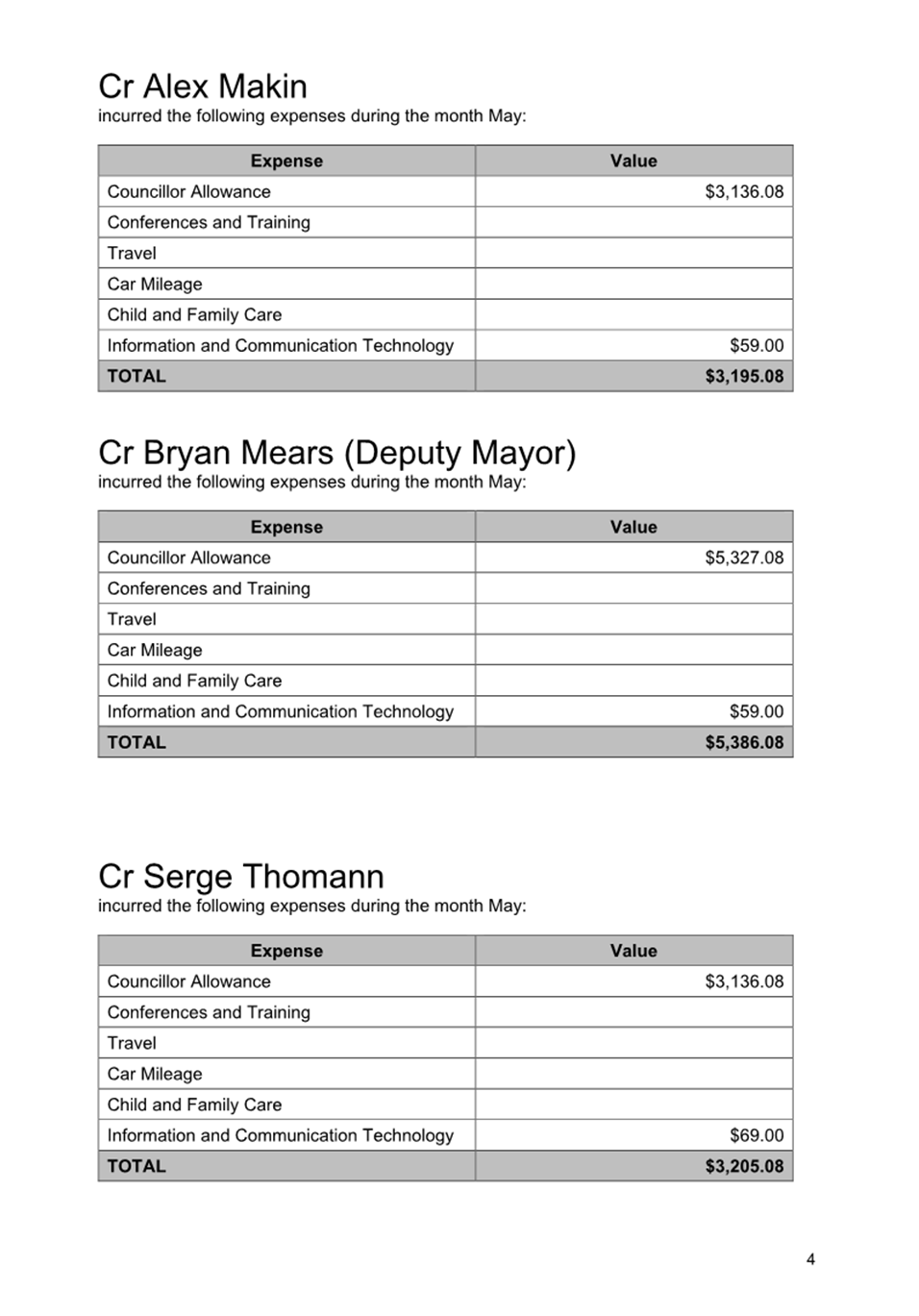
4.10 Wood Marsh created a site plan overlayed with four quadrants to assist in understanding the different activity nodes / uses of the park and their distance to the existing amenities. This imagery is shown in Image 1:
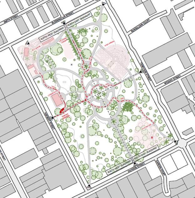
Image 1 – St Kilda Botanical Gardens site plan sectioned into quadrants / activity areas
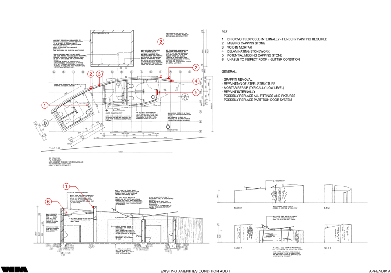
EXISTING FACILITIES
4.11 The existing facilities consist of 2 x female pans, 1 x male pan, 1 x male urinal, and 1 x unisex accessible toilet. However, these are not compliant with current DDA standards.
4.12 The amenities are constructed of ‘Castlemaine slate’ stone mortared to a brick substructure on a concrete slab and are semi-enclosed by a curved steel plate roof structure.
4.13 The facilities are award-winning, recognised in the 1994 Victoria RAIA awards for urban design.
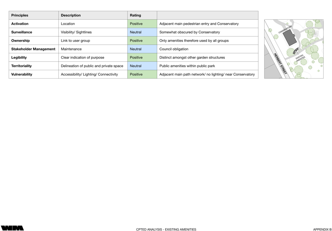
4.14 The existing amenities are in poor condition though remain functional. Some minor renewal / uplift works would improve their condition.
4.15 The current accessible toilet does not meet current DDA standards. As the building is within a fixed envelope this cannot be easily rectified without significant rework to the existing building, which would compromise its architectural significance.
4.16 A CPTED analysis undertaken as part of the feasibility study found the existing structure ‘neutral to positive’ in terms of subjective scoring, with a recommendation to provide additional lighting both internally and externally to improve the overall CPTED score.
4.17 Consideration was given to expanding the existing amenities; however, it was deemed that any renovation or expansion would compromise the architectural integrity of the building and leave some sections of the gardens poorly served.
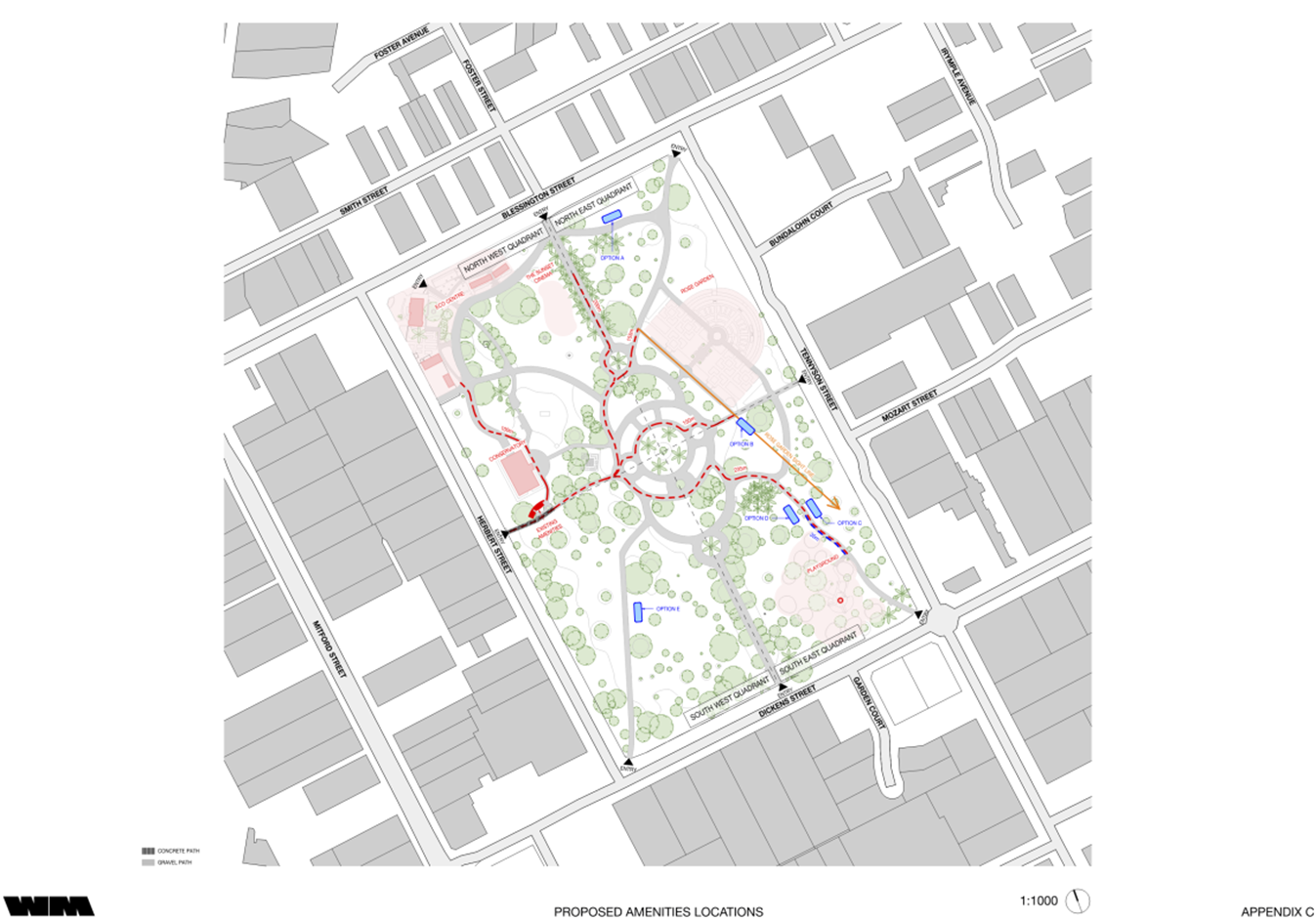
4.18 Additionally, the location of the existing amenities leaves little room for the current building to be expanded without encroaching on the nearby conservatory, pathways, or trees.
NEW AMENITIES
4.19 Given the constraints identified in expanding the existing amenities, and distance from certain activities within the park, Wood Marsh undertook a site analysis to identify possible locations for a new amenities block.
4.20 Five (5) possible location options were identified, including one (1) in the Northeast quadrant (option A), one (1) in the Southwest quadrant (option E), and three (3) in the Southeast quadrant (options B, C and D).
4.21 The five (5) possible locations are shown in Image 2:
Image 2 – Possible locations for new public amenities
4.22 An analysis of each possible location was undertaken, considering activity areas within the park, distance to existing toilets, Heritage constraints, and CPTED principles.
4.23 Following the analysis, option C in the Southeast quadrant, near the children’s playground, and adjacent Tennyson Street, was deemed the preferred option.
4.24 The site analysis identified that the playground is disproportionately far from the current public toilet block when compared to other key garden facilities. Locating new amenities nearby it will better serve both the Northeast and Southeast quadrants of the gardens, whilst also benefitting a key user-group of the park being parents and children who utilise the playground.
4.25 The visibility of the new amenities will be reduced to the residential properties across the road on Tennyson Street due to the presence of a berm (an embankment) running between the path and the park’s boundary fence.
4.26 As the gardens are heritage listed, Heritage Victoria have assessed each proposed location and provided early advice on sites likely to be granted a heritage permit.
4.27 Options B and D are located near heritage listed trees and are therefore unlikely to obtain a permit.
4.28 Option A is very close to the Port Phillip EcoCentre. It is also near the Rose Garden and likely to impact wedding and event photography, and therefore not supported.
4.29 Options C and E are deeded far enough away from any objects of heritage significance and therefore generally supported as potential locations.
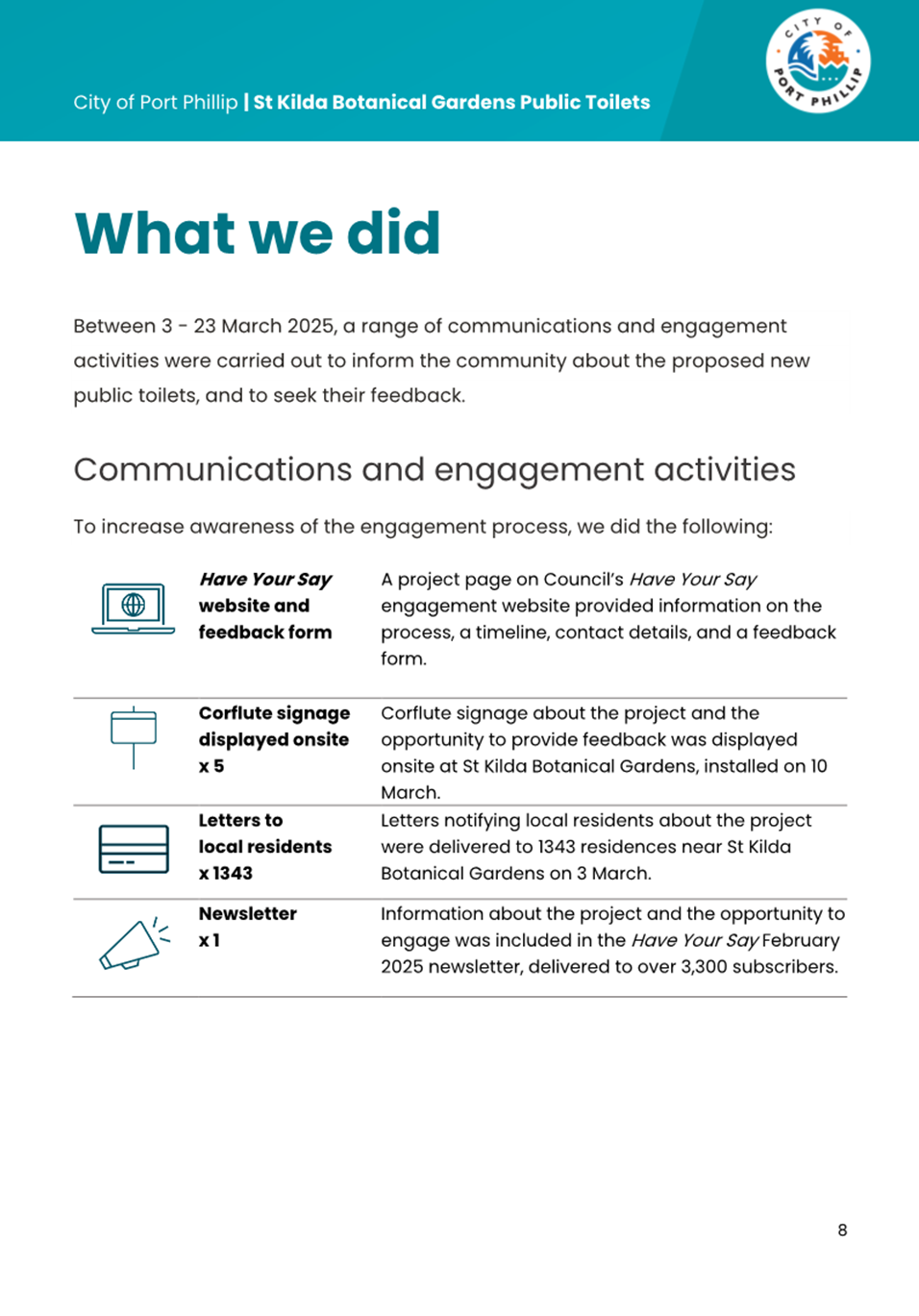
COMMUNITY ENGAGEMENT
4.30 Based on the proposed locations, community engagement occurred between 3-23 March 2025, and included a survey on the Have Your Say website. Further detail on the consultation approach is outlined in section 5 below.
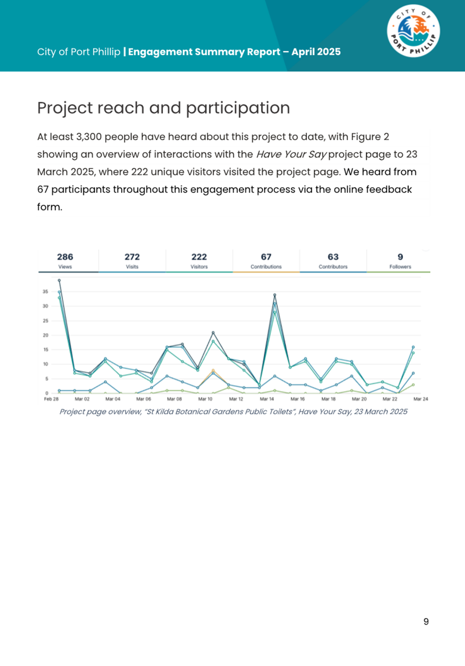
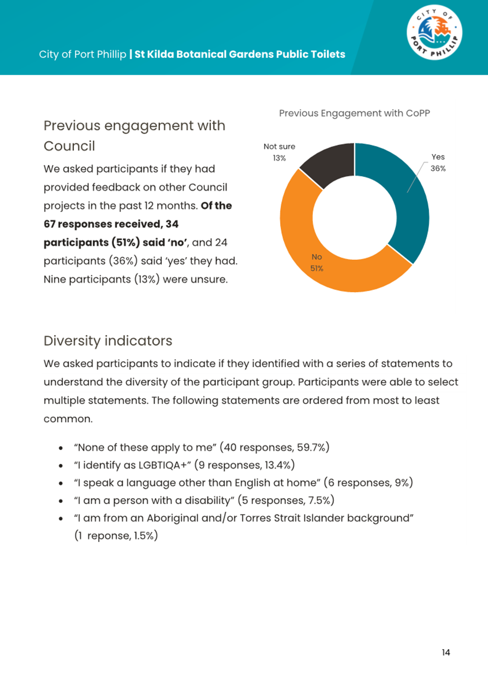
4.31 Of the 3,300 people who were notified about the project, we heard from 67 participants through the engagement process. Of these:
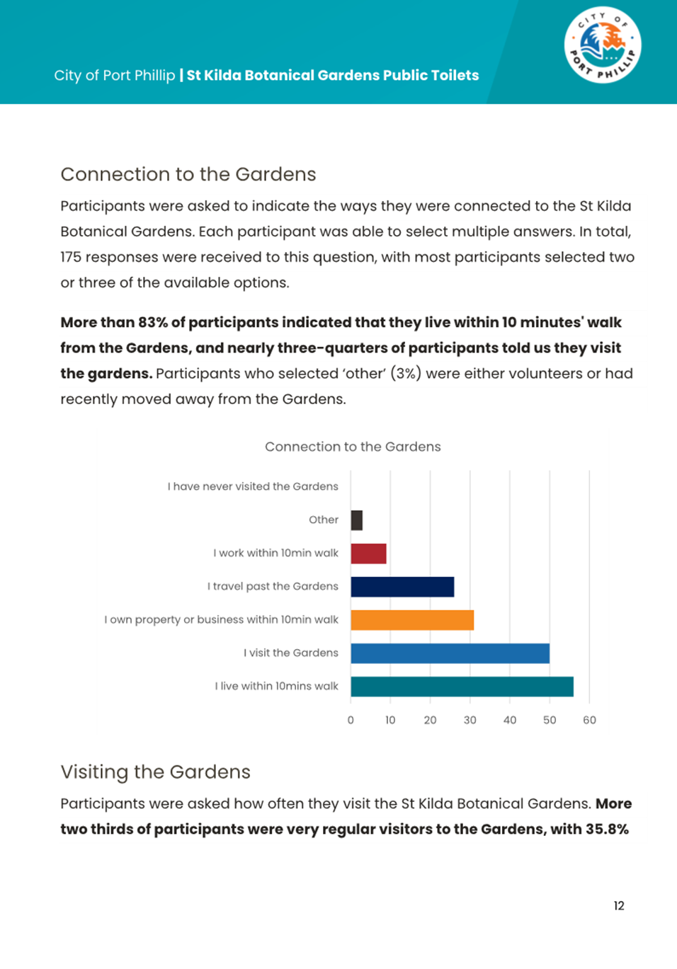
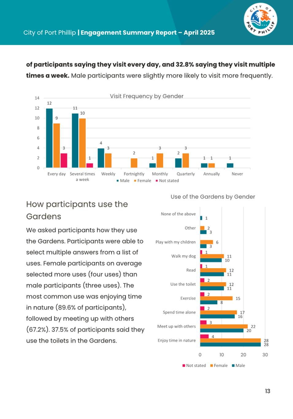
4.31.1 83% indicate that they live within a 10-minute walk of the gardens, and nearly 75% informed us they visit the gardens.
4.31.2 More than two-thirds of respondents indicated they were regular visitors to the gardens, 36% visit every day and 33% visiting multiple times a week.
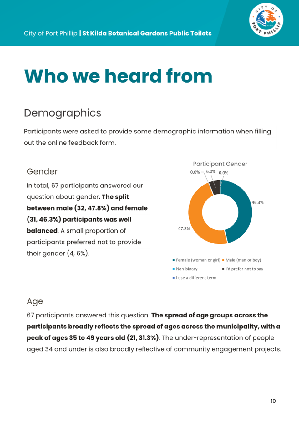
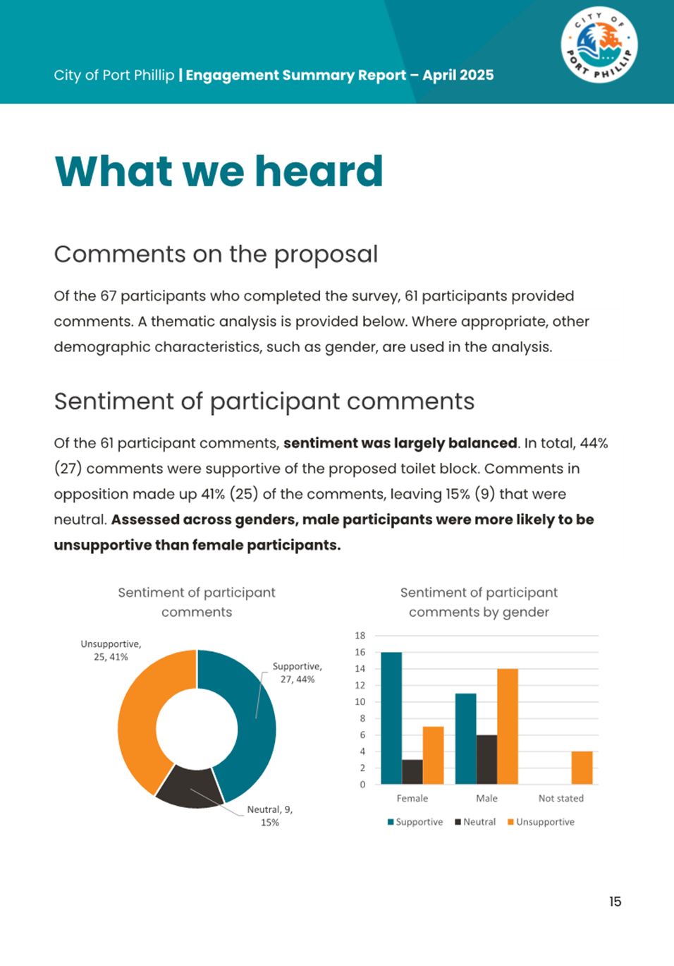
4.31.3 Of the 67 responses, 61 provided comments on the project proposal with 27 respondents (44%) being supportive of the proposed amenities, and 25 respondents (41%) expressing concerns. The remaining 9 respondents (15%) were neutral.
4.31.4 When assessing the responses by gender, male participants were generally more unsupportive than females. When considering the gender impact assessment undertaken for the public toilet plan, this is unsurprising as research shows females need to frequent toilets more often and for longer than males and therefore are likely to be more supportive of additional public toilet facilities.
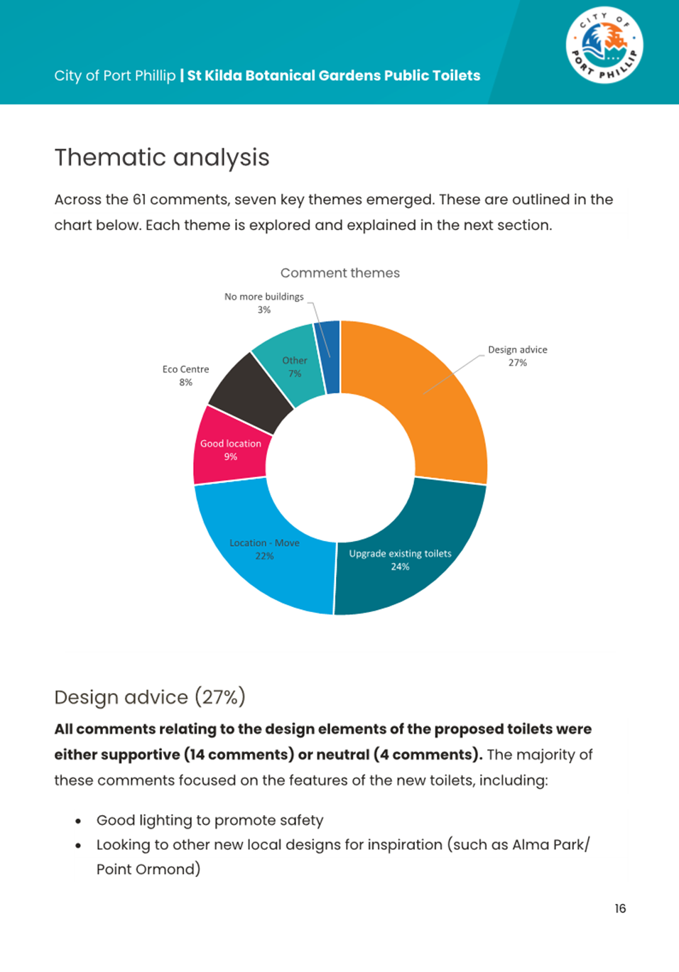
4.31.5 Across the responses, seven key themes were identified, these being:
· Design Advice (27%).
· Upgrade to the existing toilets (24%).
· Unsupportive of the proposed location (22%).
· Supportive of the proposed location (9%).
· Use of the Port Phillip EcoCentre (8%).
· Unsupportive of any more buildings in the gardens (3%).
· Other (7%).
4.32 The table below summarises the key sentiments of each theme and includes officers’ response:
|
Theme |
What we heard |
Officers’ Response |
|
Design |
Generally, the design feedback was positive, with those in favour commenting that more toilets, including accessible and all-gender toilets are important All feedback was supportive or neutral and focused on features such as: - Good lighting - Soap /hand drying / showers / ventilation - Solar power - Accessibility considerations including toddler toilet and separate changing room - Unique design but one that blends into the surroundings |
Nil |
|
Existing Toilets |
24% of respondents were unsupportive of the proposed new toilets, suggesting that if additional amenities were required, that the existing toilets should be upgraded and expanded to reduce the impact of further buildings in the park, reduce the cost of construction, and the location of existing services |
An upgrade of the existing facilities was considered as part of the initial feasibility studies; however, this was deemed not recommended for the following reasons: - Significant rework would be required to the existing building to bring it to current DDA and building code compliance. Doing so would severely impact the architectural integrity of the building - There is limited space to increase the footprint of the existing amenities to the extent required due to the location of the nearby conservatory, access paths, and trees - Certain areas of the park would remain un-serviced / would require significant travel from those areas to access the amenities - Underground service plans have been checked. A sewer main currently runs along Dickens and Herbert Streets, with three existing branches servicing the gardens from Herbert Street. If the preferred location (option C) was endorsed, a connection could be directed to Dickens Street to tie into the existing sewer main. If Option E was preferred, this could be connected to the existing main line servicing the gardens via Herbert Street - Additional to the sewer connection, both options C and E have capacity to be connected to water mains within the gardens, and the construction of the new Port Phillip EcoCentre has allowed for additional power within the main, therefore there is sufficient power capacity for a new toilet block to connect to |
|
Location |
22% of respondents were unsupportive of the proposed location due to the encroachment on highly utilised open lawn space and distance from other attractions of the gardens (such as the lake, conservatory, and Port Phillip EcoCentre) A further 9% were supportive of the location, particularly its proximity to the playground for families with children |
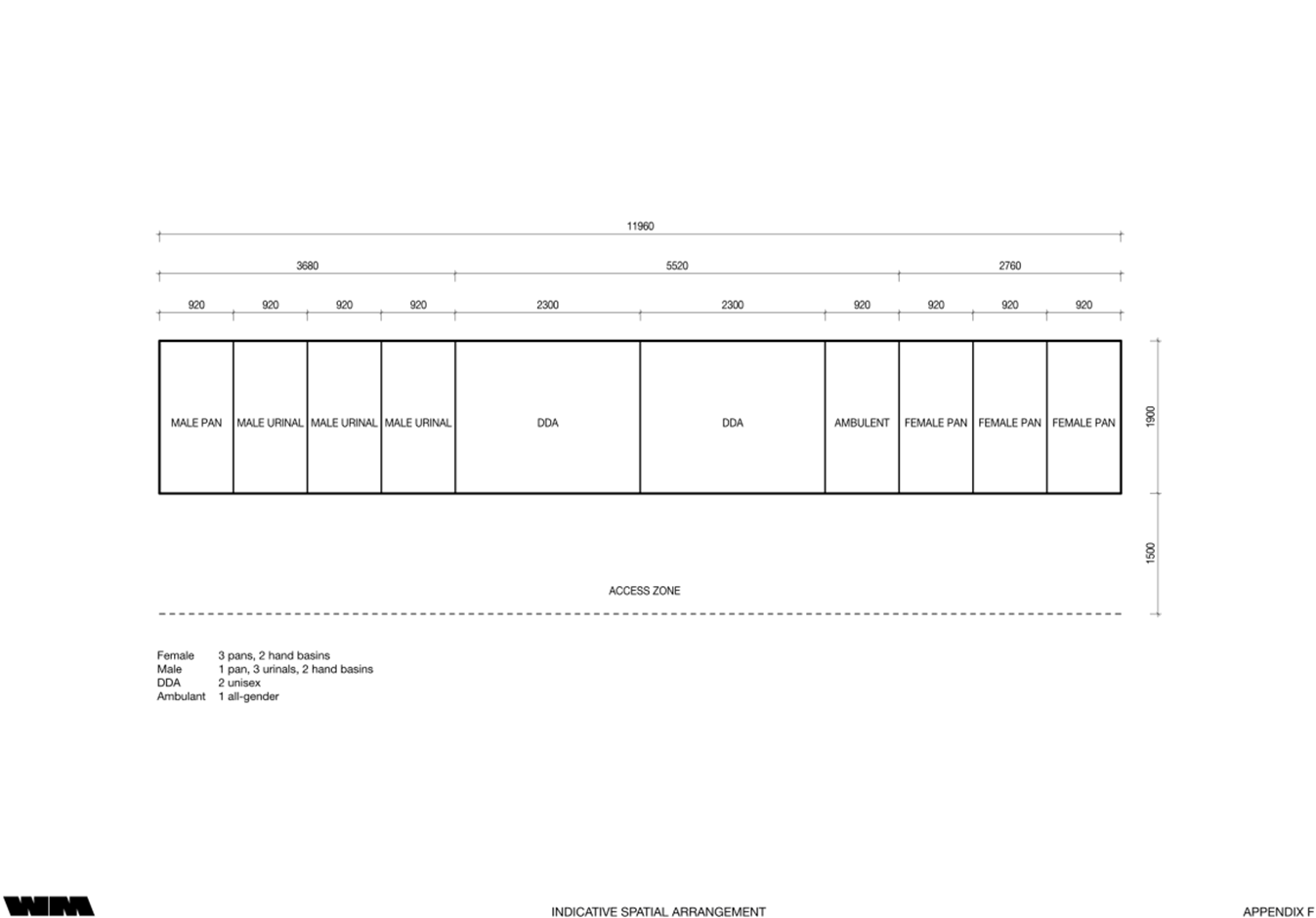
Five (5) potential locations were identified during the feasibility study and were considered according to their location, ability to connect to services, and CPTED assessment One of the design criteria identified was amenities to be located near the children’s playground, as the current facilities are a significant distance away, particularly for families with young children. Locating the facilities in the Southeast quadrant satisfies this requirement and services the Northeast quadrant. When assessing CPTED criteria, option C scored the highest and was deemed most suitable One response was received against the location of the toilet being near a children’s playground, possibly due to concerns with safety, however with correct design, orientation and location being able to easily be seen (passive surveillance), and operation and management of the toilet the risk is reduced Underground service plans have been checked. A sewer main currently runs along Dickens and Herbert Streets, with three existing branches servicing the gardens from Herbert Street. If the recommended option C is endorsed, a connection can be directed to Dickens Street to tie into the existing sewer main. If option E was preferred, this could be connected to the existing main line servicing the gardens via Herbert Street Additional to the sewer connection, both option C and A have capacity to be connected to water mains within the gardens, and the construction of the new Port Phillip EcoCentre allows for additional power within the main, therefore there is sufficient power capacity for a new toilet block to connect to Officers understand the sentiment about loss of open space through another building, but also acknowledge the need for additional amenities. Officers have proposed a minimum of five new pans, although the preference is up to eight, including 2 x DDA (right hand and left-hand access), 1 x all gender Ambulant, 3 x female pans, 1 x male pan, and 3 x male urinals. This allocation addresses the required number of toilets for the capacity issues, given the equivalent of 7 x toilets are hired annually, and allows for population and visitation increases. This is also equitable, providing the preferred makeup of male / female / all gender toilets and provision for both left and right-handed transfer for wheelchair users Based on the feedback, officers believe reducing the overall footprint to a maximum of 4-5 toilets may be suitable to minimise the impact on open space, whilst still meeting access and inclusion requirements. This may include 1 x right hand DDA toilet, 1 x male, 1 x female, and 1 x Ambulant all-gender toilet. Whilst right hand accessible toilets are more common due to the higher population of right-handed people, this solution would not be considered equitable, and a second left-hand transfer accessible toilet could also be considered |
|
EcoCentre |
Five comments received were unsupportive of the proposal and queried why new toilets weren’t included in the recently completed new EcoCentre building |
The new Port Phillip EcoCentre, designed pre COVID, does not include public toilets due to design limitations. Toilets within the building are accessible only during opening hours and are intended for staff, school groups, and centre users. Council has approved an 18-month trial to staff the Port Phillip EcoCentre on weekends, allowing limited weekend access to these toilets. However, they will remain closed after 5pm and on public holidays, which are peak times for garden use The proposed new public toilets remain necessary to meet broader demand; de-scoping them is not recommended. Additionally, the location of the Port Phillip EcoCentre is a significant distance from the playground and park users of the Southeast quadrant, disadvantaging these park users |
|
No. of Buildings |
3% of respondents specifically called out reducing the number of buildings in the gardens, and that these detract from the heritage of the gardens and were therefore unsupportive of the project proposal |
Officers understand this sentiment; however, this does not detract from the need for additional facilities within the gardens. The footprint and design will be such that it considers the heritage of the park and looks to enhance the natural elements of the gardens, rather than detract from it |
|
Other |
Other comments were received outside the scope of the project and will be passed on to relevant project teams |
Nil |
4.33 With the inclusion of the noted mitigation strategies, namely through consideration of the footprint and design of the building, it is recommended that council proceed to the design stage of the project within the preferred location (option C).
4.34 Minor upgrade works of the existing amenities have been identified to be completed through Council’s minor capital works program to align with the construction of the new amenities.
5. CONSULTATION AND STAKEHOLDERS
5.1 Key internal stakeholders were engaged from the outset of the project through a project kick-off meeting and feasibility feedback workshop to determine the requirement for new toilets, the number of toilets, and potential location of toilets. These included officers from the following teams:
5.1.1 Project Delivery.
5.1.2 Property and Assets.
5.1.3 City Design.
5.1.4 Building Maintenance.
5.1.5 Open Space and Recreation.
5.1.6 Sustainability.
5.1.7 Community Building and Inclusion.
5.2 Following completion of the feasibility report from the consultants, these stakeholders were invited to attend a discussion to review the options and preferred location, with a consensus in agreeance with the consultants that option C was most suitably located.
5.3 Community engagement was undertaken from 3-23 March 2025 to inform the community about the proposed new public toilets.
5.4 To increase awareness of the engagement process, the following activities were undertaken:
5.4.1 A project page on Council’s Have Your Say engagement website.
5.4.2 Five (5) corflute signs were erected on site within the gardens on 10 March 2025.
5.4.3 Letters were sent to 1,343 residences near the gardens on 3 March 2025 notifying residents of the project.
5.4.4 Information about the project and the opportunity to engage was included in the February 2025 Have Your Say newsletter, which was delivered to over 3,300 subscribers.
5.5 The purpose of the engagement was to inform the community of the project and seek feedback on the following aspects:
5.5.1 The need for more toilets within the gardens.
5.5.2 The proposed location of the new toilets.
5.5.3 The proposed number and makeup of the new amenities block.
5.5.4 Any other general feedback relating to the project.
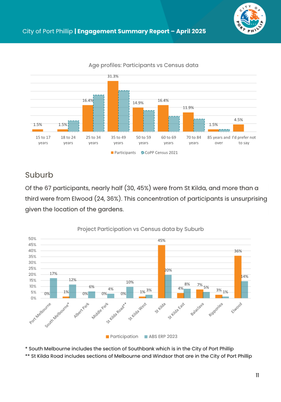
5.6 During the engagement period, the Have Your Say page was visited 222 times, with 67 surveys completed, of which the majority (81%) were from residents of St Kilda or Elwood.
5.7 The survey included standard demographic and diversity questions as well as some more specific questions for the community to respond to, including:
5.7.1 The ways participants were connected to the gardens, i.e. visit the gardens, live within a 10-minute walk of the gardens, travel past the gardens etc. with the ability to select multiple answers.
5.7.2 How often participants visit the gardens.
5.7.3 How participants use the gardens.
5.7.4 Supportive/unsupportive and comments on the project proposal.
5.8 Attachment 1 provides further detail of the community engagement.
5.9 To keep the community informed, Council’s Have Your Say page and the project webpage will continue to be updated throughout the duration of the project to provide updates on design and project progress.
6. LEGAL AND RISK IMPLICATIONS
6.1 Whilst Council is not legally required to provide public toilet amenities, it is generally expected that Council’s will provide these.
6.2 Council faces reputational and legal/financial risks if toilets are not maintained and renewed to ensure they are clean, safe and accessible to the entire community.
6.3 There is a further chance of reputational and project schedule risk because of potential further objections from the community and key stakeholders relating to the project proposal as the project progresses to the design phase.
6.4 Heritage, and building permits will be required prior to construction.
6.5 Whilst the Building Code of Australia (BCA) does not recognise all-gender toilets, to restrict any person from using the bathroom that best affirms their gender may be considered unlawful.
7. FINANCIAL IMPACT
7.1 The project has a total budget of $815,000 over three years to accommodate the feasibility, design, permit and construction requirements.
7.2 The construction of new amenities will save Council approximately $11,000 per annum on the provision of temporary amenities. These savings will be partially offset by the additional annual operating costs required for the new facilities, estimated at approximately $45,000 to $50,000 (this includes cleaning, security, and general maintenance).
7.3 The Building Code of Australia (BCA) does not recognise all-gender toilets; therefore, a performance solution will be required during the design and permit phases to accommodate this design requirement. This will have additional costs of approximately $10,000 to $15,000, which has already been factored into the budget.
8. ENVIRONMENTAL IMPACT
8.1 Council’s Public Toilet plan includes guidelines for climate change consideration throughout design and construction, along with sustainable minimum performance standards that are to be adhered to when constructing new or upgrading existing public toilets to minimise environmental impacts. These guidelines will be followed through the design phase to minimise environmental impacts.
8.2 The use of solar power will be investigated through the design phase, particularly since the toilets will be closed between dusk and dawn (outside of evening events).
8.3 There would be a loss of green space because of the new building construction.
9. COMMUNITY IMPACT
9.1 Council has consulted on the proposed new toilets as part of its Public Toilet Plan 2023-2033, which has created an expectation of renewal / upgrade / additional facilities amongst the community.
9.2 Specially, the community has now been consulted on the specifical proposal for new toilets in the preferred location and reviewed the feedback received.
9.3 While there will be some loss of open green space, as identified through the community consultation, the proposed amenities will provide compliant, accessible, and inclusive facilities for our diverse community to utilise.
9.4 It is expected that additional facilities, that are new and easier to access, particularly for those with access issues, and parents with pushchairs and young children, will encourage and allow park users to spend longer periods of time within the gardens.
9.5 Further, additional permanent facilities would remove the need for the provision of unsightly and costly temporary toilets over the summer holiday period.
10. Gender Impact Assessment
10.1 A gender impact assessment was completed when Council’s public toilet plan was developed and has been referred to in the planning phase of this project. Council’s Gender Equity Advisor has also been consulted through the planning phase.
10.2 The Gender Impact Assessment (GIA) identified the following key findings which have been considered during the planning phase of this project:
10.2.1 Everyone requires the use of toilet facilities, no matter their age, gender, or (dis)ability.
10.2.2 Women on average take 2.3 times longer to use the toilet than men, and older people or those with disability often need more time and space in a toilet.
10.2.3 Women generally require more trips to the toilet.
10.2.4 The split of Male / Female toilets is not usually equitable as male urinals often offer a greater provision for males than females.
10.2.5 Parents / carers of all genders require access to toilets with their children therefore parents’ rooms or baby change tables need to be accessible to all-genders.
10.2.6 Trans and non-binary people require equitable and safe access to toilets which is not always provided.
10.2.7 The location and design of public toilets can affect different genders differently – women and trans / non-binary people are often more likely to feel unsafe in the public realm when using public facilities.
10.2.8 Older and Culturally and Linguistically Diverse (CaLD) women particularly often prefer the choice of using a female toilet.
10.2.9 Wheelchair users are not the only people needing accessible toilets – people who require toileting equipment, people with assistance animals, persons with a pram, and people with carers all require additional space.
10.2.10 Choice supports inclusion – having a choice to use a gendered or non-gendered amenity creates a feeling of inclusion and safety depending on personal preference, culture, background or experience.
10.3 As a result of these findings, one of the key recommendations from the GIA was to investigate design options for all new and upgrade works on public toilets to include an all-gender option, along with male, female and accessible toilets.
11. ALIGNMENT TO COUNCIL PLAN AND COUNCIL POLICY
11.1 The project aligns to the endorsed City of Port Phillip Public Toilet Plan 2023-2033.
11.2 The project also aligns to the following strategic directions:
11.2.1 Strategic direction 1 Inclusive Port Phillip:
· Strategic Objective: A city that is a place for all members of our community where people feel supported and comfortable being themselves and expressing their identities.
· Strategy: “Port Phillip is more accessible and welcoming for people of all ages, backgrounds and abilities”.
11.2.2 Strategic direction 3 Sustainable Port Phillip:
· Strategic Objective: A city that has a sustainable future, where our environmentally aware and active community benefits from living in a bayside city that is greener, cooler, cleaner and climate resilient.
· Strategy: “The city is actively mitigating and adapting to climate changes and invests in designing, constructing and managing our public spaces to optimise water sustainable and reduce flooding”.
11.2.3 Strategic direction 5 Well Governed Port Phillip:
· Strategic Objective: A city that is a leading local government authority, where our community and our organisation are in a better place as a result of our collective efforts.
· Strategy: “Port Phillip Council is a high-performing, innovative, inclusive and balances the diverse needs of our community in its decision-making” and “Port Phillip Council is cost-effective, efficient and delivers with speed, simplicity and confidence” and “Our community has the opportunity to participate in civic life to inform Council decision-making”.
12. IMPLEMENTATION STRATEGY
12.1 TIMELINE
12.1.1 Once endorsed, Officers will commence the design phase of the project as per the following timelines:
2025/26 Financial Year
· Procurement for qualified architect – September 2025
· Concept Design completed – October 2025
· Detailed Design completed – November 2025
· Permits approved – January 2026
· Public Tender for construction – March 2026
· Construction contract award – June 2026
2026/27 Financial Year
· Construction commencement – July 2026
· Construction completion – November 2026
12.2 COMMUNICATION
12.2.1 Project updates will be communicated via the Have Your Say page.
12.2.2 Council has a public toilet project webpage which will continue to be updated throughout the duration of the project.
13. OFFICER MATERIAL OR GENERAL INTEREST
13.1 No officers involved in the preparation of this report has declared a material or general interest in the matter.
|
ATTACHMENTS |
1. Engagement Summary Report 2. Feasibility Report |
Meeting of the Port Phillip City Council
18 June 2025
|
Edwards Park Public Amenities Location |
|
|
Executive Member: |
Lachlan Johnson, General Manager, Operations and Infrastructure |
|
PREPARED BY: |
Vicki Tuchtan, Manager Property and Assets Kimberley Ingram, Divisional Project Portfolio Manager Golpooneh Rahimlabaf Zadeh, Project Manager |
1. PURPOSE
1.1 This report responds to community feedback, and a community petition, seeking Council to consider further options for the sighting and upgrade of public amenities in Edwards Park.
1.2 The report provides three location options for Council to consider.
2. EXECUTIVE Summary
2.1 Edwards Park is a highly utilised public park situated in Port Melbourne with existing public amenities situated at the northern edge of the park to service park users, particularly families and children. The amenities are also utilised by mobile workers including public transport operators (Uber and Taxi drivers) and tradespeople needing public amenities in this location.
2.2 The current public toilets in Edwards Park have been earmarked for an upgrade in Council's Public Toilet Plan 2023-2033 due to their poor condition and failure to meet the Disability Discrimination Act 1992 (Cth) (DDA) requirements.
2.3 A feasibility study aimed at determining whether to retain the existing site or relocate the toilets considered factors such as site constraints, heritage significance of the park, residential impact, equality of access, tree impacts, and ‘Crime Prevention Through Environmental Design’ (CPTED) principles, in line with the requirements of Council’s Public Toilet Plan 2023-2033.
2.4 The study identified eight (8) potential locations where new amenities could be constructed, including retaining the existing location. These locations were then scored by a number of subject matter experts in their field against the criteria.
2.5 The highest scoring site (location 2b) was located on the Esplanade West frontage near the playground. This site was the subject of a community engagement process, during which members of the community expressed dissatisfaction with the proposed location including lack of sight line from the playground and impact on existing trees.
2.6 Residents presented a petition to Council requesting Council reconsider the assessment criteria used and seek alternate locations for consideration. This report outlines that assessment and proposes three (3) potential locations.
2.7 In response to the petition, officers reviewed the assessment criteria against the endorsed public toilet plan. The assessment criteria, which included consideration of the visibility of the public toilets to residential properties, were found to be appropriate.
2.8 Further, in response to the petition, officers reviewed the park and considered additional potential locations for a new public toilet. In the original assessment, officers had considered incorporating the toilets with the Port Melbourne Community Centre (PMCC) / Trugo Club, but this had been excluded due to costs significantly exceeding the allocated budget and other practical restrictions. As part of the review of potential locations, this was revisited and an option to locate the public toilet just outside the fence line (to the west) of the PMCC / Trugo Club has been identified and included in the assessment.
2.9 As outlined in this report, officers propose three (3) potential locations, including the previously endorsed location 2b.
2.10 Officers recognise the community sentiment expressed in the consultation and the petition presented to Councillors. As this report outlines, officers propose that options 1a (south-west corner of the park) and 5 (adjacent the PMCC / Trugo Club) also be considered by Councillors, to reduce the impact on adjacent residents.
2.11 If option 1a or 5 is adopted, the project budget is recommended to be increased to allow for additional investment in sewer outfall infrastructure, lighting, path network upgrades, wayfinding signage, and an anti-graffiti mural. These additional investments would help to address some of the concerns identified with these potential locations.
|
That Council: 3.1 Extends its thanks to the community for their feedback on the location options for upgrading the public toilets in Edwards Park. 3.2 Notes the updated assessment of options within the park against the considerations required under the Public Toilet Plan. 3.3 Resolves to construct new public amenities in Edwards Park at (insert option): 3.3.1 Option 1: Location 1a in the southwest corner of the park, and increase the project budget by up to $70,000 for additional sewer outfall pumping infrastructure, by drawing down upon the Asset Renewal Reserve. OR 3.3.2 Option 2: Location 2b (previously endorsed) on the Esplanade West frontage of the park OR 3.3.3 Option 3: Location 5 adjacent the Port Melbourne Community Centre / Trugo Club), and increase the project budget by $70,000 for pathway, lighting and other minor upgrades, by drawing down upon the Asset Renewal Reserve. |
4. KEY POINTS/ISSUES
4.1 While not a legislative requirement, it is generally expected that local councils will provide suitable public toilet facilities for community members and visitors to the municipality. As such, Council currently has 49 Council managed Public Toilet facilities and has a license agreement for a further two (2) facilities to provide public access.
4.2 Several issues that arise from public toilet provision result from poor location planning. Historically public toilets were hidden away ‘out-of-sight’, leading them to become ideal locations for anti-social behaviour to occur.
4.3 In response to this, Council has adopted through its Public Toilet Plan 2023-2033 that Crime Prevention Through Environmental Design (CPTED) principles must be considered in the renewal / upgrade or installation of new public toilets.
4.4 Location citing is a key principle of CPTED to reduce the likelihood of anti-social behaviour and increase feelings of safety for the community utilising amenities.
4.5 Whilst most of the community are in favour of the provision of public toilets, there is an understandable reluctance for many people to have toilets located near their homes or businesses due to perceptions that they attract anti-social behaviour and their visual appearance. There is often a trade-off required between a highly visible location and view from neighbouring properties when located in a residential area.
Edwards Park – Initial Feasibility Assessment & Community Engagement
4.6 Edwards Park is a highly utilised public park situated in Port Melbourne. It is home to avenues of Canary Island palm trees at the southern end and play and picnic areas at the northern end.
4.7 There are existing public amenities situated at the northern edge of the park to service park users, particularly families and children. The amenities are also utilised by mobile workers including public transport operators (Uber and Taxi drivers) and tradespeople needing public amenities in this location.
4.8 The existing public amenities have been earmarked for an upgrade in Council's Public Toilet Plan 2023-2033 due to their poor condition and failure to meet the Disability Discrimination Act 1992 (Cth) (DDA) requirements.
4.9 Due to their location, the existing facilities do not meet Crime Prevention Through Environmental Design (CPTED) principles as they suffer from poor visibility and accessibility from adjacent streets, leading to safety concerns.
4.10 Further, the existing location is not near to any parking options, and residents of Lagoon Way often have their access impeded by vehicles who have stopped to access these existing amenities.
4.11 To address these issues, a feasibility study was conducted at the commencement of the planned project. This study aimed to determine whether to retain the existing site or relocate the toilets, considering factors such as site constraints (water / sewer / electrical connection availability), heritage, residential impact, equality, tree impacts, and CPTED principles.
4.12 The initial study identified eight (8) potential locations where the new amenities could be constructed as shown in Image 1 below (numbered in pink text), including at the current location (numbered 4 on Image 1):
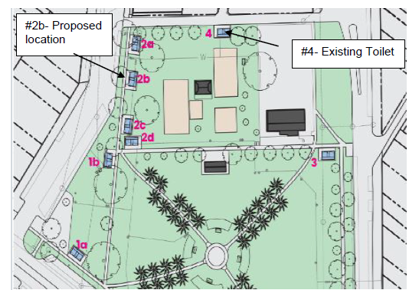
Image 1 – Initial assessment of potential sites for new amenities
4.13 Location 2b shown above was deemed the most suitable location based on the assessed criteria and community engagement undertaken on the proposed site, which found a number of community members were unsupportive of the proposed location based on its visual impact to nearby residents and other concerns.
4.14 The results were presented at an ordinary meeting of Council on 11 December 2024. Location 2b was subsequently endorsed as the proposed new location.
4.15 At the ordinary meeting of Council on 11 December 2024, community members raised objections to the proposed location (2b), citing concerns about the potential visual impact of the new toilet block. To address these concerns officers attended a community meeting in the park on 17 January 2025 to discuss potential strategies to mitigate the visual impact.
4.16 During the onsite meeting, whilst supportive of an upgrade to the amenities, several community members opposed the chosen location, expressing worries that the proposed location would negatively detract from the park.
4.17 Since this time, Council has continued to receive responses both for and against the proposed location, including a petition presented to Council on 19 February 2025 requesting that Councillors pause the project, revoke the decision to construct at location 2b, reassess the evaluation criteria used to include not being in front of residents homes, maintain play / picnic shaded areas for park users, and identify alternative sites that can be further consulted on with the community.
4.18 In response, officers temporarily paused procurement of a suitable contractor until such time that Council could consider a response to the petition.
Edwards Park – Updated Assessment
4.19 Officers reviewed the assessment criteria against the public toilet plan (the plan). The assessment criteria utilised were found to align with the plan. Additionally, the request of the petitioners to consider the impact on residential properties had been included.
4.20 Officers have identified another potential location near the Port Melbourne Community Centre (PMCC) / Trugo Club, as shown in Image 2 overpage. This alternate site – labelled location ‘5’ – has been assessed against the same criteria and scored accordingly.
4.21 Location 5 is outside of the existing fence that surrounds the PMCC / Trugo Club. There is a need to maintain some separation from the existing building to simplify building compliance requirements (locating the toilet directly adjacent to the existing building would likely require consequential building compliance works). This pushes the location of the toilet close to the playground swing set, which is considered in the criteria assessment.
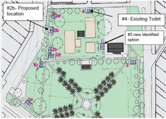
Image 2 – additional location option for new amenities (location 5)
DETERMING THE PREFERRED LOCATION
4.22 Council’s Public Toilet Plan 2023-2033 recommends that the following criteria are considered when locating a new toilet:
· Must be located in areas of high demand within the community, in particular areas where high pedestrian traffic volumes exist and where there are ‘public activity generators’ such as BBQ facilities and play equipment.
· Understand the surrounding area and identify key stakeholders to understand how installation may impact them.
· Location of underground services.
· CPTED principles to ensure they are located in an area that is easily visible and accessed to reduce the likelihood of anti-social behaviour occurring.
4.23 Based on these recommendations, assessment criteria were developed to score each of the potential options to help determine the best possible location.
4.24 In addition to the above recommendations, the assessment included other relevant issues such as universal design, heritage, tree impact, and residential impact.
4.25 Scores were adopted on a scale from -2 to +2 (worst to best). For example, locations closest to the playground scored +2, while the location furthest away scored -2. All criteria were equally weighted.
4.26 Some of the assessment criteria can be assessed objectively, such as distances, however others, such as the CPTED assessment, are assessed subjectively.
4.27 In order to reduce the impacts of individual bias, nine (9) Council officers were asked to assess the options. Topics such as heritage, universal design, and tree impact required a subject matter expert and were therefore assessed by single individuals with expertise in that area. Water and sewer connections were evaluated based on distance. The remaining criteria were reviewed by all, with results then averaged to give a final score, with CPTED scores given the same weighting as all other criteria.
4.28 In identifying and scoring the locations, some initial site constraints became apparent that either ruled out a potential option, or negatively impacted the scoring. These include:
Heritage Overlay:
· Edwards Park is of local historical, social, and aesthetic significance, reflecting the location of the original saltwater lagoon, and is home to the longest continual use playground in Port Melbourne. As a result, the park is partially covered by Heritage Overlay 448, meaning any sites located within this overlay are likely subject to a Heritage Permit.
· The Heritage Overlay includes the radial avenues of palm trees and the northern area where the PMCC / Trugo Club and playground are located. The triangular site on the western side and eastern easement are not included in the overlay and therefore not subject to a Heritage Permit.
· While the playground and PMCC / Trugo Club are within the overlay, the southern end with the palm tree avenues has higher Heritage significance and therefore any locations near to this area (locations 1b, 2c, 2d and 3) are unlikely to obtain a heritage permit, or would be subject to strict conditions within the permit, thus scored lower accordingly.
Existing Services:
· There are two (2) existing water connections servicing the park – one on Esplanade East and another on Lagoon Laneway. During the feasibility process, Council did apply directly to South East Water to permit another property connection branch to service a new toilet, however this application was denied and Council was informed that as there are already two (2) connection branches, they would not consider another. The further away a toilet is located from these connections, the more significant trenching works are required to reach a connection.
· Summarised below are the merits of each site considered. Note bolded text indicates a major constraint to the location, rendering the site unviable for construction. Such sites were therefore discarded for any future evaluations.
|
Site |
Pros |
Cons |
||
|
1a |
- No heritage impact, outside of heritage overlay - Good pedestrian and DDA accessibility - Good connections to parking, cycle path, public transport network and Bay St activity centre - Excellent visibility and natural surveillance according to CPTED principles - Minimal residential impact due to distance from housing, tree planted median strip along Liardet Street, and tall trees obscuring apartments opposite the park - No impact to trees |
- Furthest site from existing water / sewer connections. This could be addressed through an additional $50k for initial works and increased operating costs funded for maintenance of pumping system - Significant distance from the playground |
|
|
|
1b |
- Good pedestrian and DDA accessibility - Good connections to parking - Fair connection to cycle path, public transport network, and Bay Street activity centre - Nearer to playground |
- Outside of heritage overlay, however, intersects significant heritage area of park and likely to require heritage permit which is unlikely to be granted or granted with strict conditions - Significant distance from existing water / sewer connections, unviable to connect - Close proximity to manhole covers which may be impacted - Lower residential impact compared to some other sites. Most likely to impact multi-unit building opposite - Tree impacts due to proximity to existing trees likely requiring tree removal - Less visible and inward facing (to align to existing path), making natural surveillance difficult during darkness according to CPTED principles |
|
|
|
2a |
- Relatively close to existing service connections - Within heritage overlay, however, is on the edge of the park and given the distance from the southern palm tree avenue end and no impact to playground it is expected a heritage permit will be relatively easy to obtain - Good pedestrian and DDA accessibility - Good connections to parking - Good visibility and natural surveillance according to CPTED principles - Near the playground though further from some playground elements - Minimal visual impact on the park |
- Tree impacts due to proximity to existing trees with potential requirement of tree removal - Reduces shaded open space availability - Medium residential impact due to properties across the street (including double storey property with balconies overlooking park) with no barriers therefore building in direct line of sight |
|
|
|
2b |
- Relatively close to existing service connections - Within heritage overlay, however, is on the edge of the park. Given the distance from the southern palm tree avenue end and no impact to playground it is expected a heritage permit will be relatively easy to obtain - Good pedestrian and DDA accessibility as the most central location to playground, footpath and car parking - Good connections to parking - Close location to all playground elements - Good visibility and natural surveillance according to CPTED principles - Maintains good views of the playground from the street - It is anticipated that the project can be delivered within the existing budget at this location |
- Close proximity to trees, however not expected to impact tree health or require tree removal due to distance between mature trees providing enough space for new building - Reduces shaded open space availability - Residential impact due to properties across the street (including double storey property with balconies overlooking park) with no barriers therefore building in direct line of sight - Irrigation line will require relocation |
|
|
|
2c |
- Fair natural surveillance according to CPTED principles - No tree impact due to distance from trees - Reasonably accessible with nearby car parking - Relatively close to the playground |
- Further away from existing service connections - Irrigation line will require relocation - Inside heritage overlay and nearby southern significant heritage area therefore likely challenging to obtain a heritage permit or have strict conditions imposed - Residential impact, likely mostly impacting multi-unit building opposite |
|
|
|
2d |
- No tree impact due to distance from trees - Reasonably accessible though slightly further from car parking - Relatively close to the playground |
- Further away from existing service connections - Irrigation line will require relocation - Inside heritage overlay and adjacent southern significant heritage area therefore unlikely to obtain a heritage permit or have strict conditions imposed - Slightly obstructs views of the playground from the south - Reduced natural surveillance as it only faces Dow Street - Medium residential impact, likely mostly impacting multi-unit building opposite |
|
|
|
3 |
- Near to existing service connection on Esplanade East - Relatively accessible though limited car parking available - Low residential impact due to positioning of properties, location of McCormack Street and existing PMCC / Trugo club - No tree impact due to distance from trees |
- Technically outside the heritage overlay however is likely to be sensitive given it appears within the radial paths and blends cohesively with the park therefore unlikely to be able to obtain a heritage permit - Significant distance from playground with limited visibility to playground from the site - Poor visibility / natural surveillance as per CPTED principles |
|
|
|
4 |
- Has existing service connections - Inside heritage overlay, however existing structure so therefore expected to have no impact - Near to playground |
- Not located near to existing footpaths therefore no DDA access (other than via laneway which is a safety risk). Could be made compliant with the addition of new compliant paths of travel at an estimated cost of $10,000 - Not located near carparking - High residential impact to residents of Lagoon Way due to proximity of building to residential properties and impact of access to these properties when motorists block the laneway when accessing the amenities, although noting that these are existing facilities - Potential tree impact due to proximity of existing tree and how this would be impacted by a bigger footprint of the toilet block to accommodate DDA compliant facilities - Poor visibility and passive surveillance as views to toilet are obstructed due to its remote location and by the playground equipment - Poor visibility from the street and within the park |
|
|
|
5 |
- Much reduced visual residential impact due to location towards the centre of the park - Existing services connections are nearby (servicing the existing park) - Near to the playground - Within heritage overlay, given the distance from the southern palm tree avenue end and no impact to playground it is expected a heritage permit will be able to be obtained - Near to accessible park paths |
- Will require the removal of potentially up to four (4) trees - Poor visibility and passive surveillance as views to toilet are obstructed due to its distance from the roads and by the playground equipment - Significant distance from footpaths and carparks. As with current location, additional pathways will need to be constructed - Toilet building will be in close proximity to the existing swing set; recommended that if this location is adopted that the swing set be relocated because of risk of swings in motion - May limit future potential for playground upgrade which is being planned for future years as part of a review of Council’s playspace strategy |
|
|
4.29 Once the scores were collated, they were averaged out and the highest scoring sites were identified (refer Table 1 below).
|
|
1A |
1B |
2A |
2B |
2C |
2D |
3 |
4 |
5 |
|
Water connection |
-2.0 |
0.0 |
1.0 |
1.0 |
0.0 |
0.0 |
-2.0 |
2.0 |
2.0 |
|
Sewer connection |
-2.0 |
-1.0 |
1.0 |
1.0 |
-1.0 |
-1.0 |
1.0 |
2.0 |
1.5 |
|
Electrical connection |
0.0 |
0.0 |
0.0 |
0.0 |
0.0 |
0.0 |
0.0 |
0.0 |
0.0 |
|
Heritage impact |
2.0 |
-2.0 |
2.0 |
2.0 |
-1.0 |
-2.0 |
-2.0 |
2.0 |
1.0 |
|
Equality |
1.0 |
0.0 |
1.0 |
2.0 |
1.0 |
0.0 |
-1.0 |
-2.0 |
-1.0 |
|
Proximity to the playground |
0.5 |
1.8 |
1.8 |
2.0 |
2.0 |
2.0 |
-2.0 |
1.8 |
2.0 |
|
Residential impact |
2.0 |
0.8 |
0.0 |
0.0 |
0.5 |
0.8 |
1.3 |
-0.8 |
1.5 |
|
Tree impact |
2.0 |
-2.0 |
-2.0 |
-1.0 |
2.0 |
2.0 |
2.0 |
-1.0 |
-2.0 |
|
CPTED |
|||||||||
|
- Visibility |
1.7 |
-0.1 |
1.4 |
1.8 |
1.4 |
0.6 |
-0.1 |
-0.9 |
-0.6 |
|
- Access |
1.3 |
1.3 |
1.7 |
2.0 |
1.7 |
1.3 |
-0.7 |
-0.9 |
-0.6 |
|
- Light |
1.4 |
0.7 |
0.6 |
0.8 |
1.0 |
0.6 |
0.9 |
0.6 |
0.0 |
|
- Location |
1.0 |
0.4 |
1.0 |
1.5 |
1.0 |
0.3 |
-0.4 |
-0.4 |
-1.0 |
|
- Orientation |
1.4 |
0.9 |
1.0 |
1.3 |
0.9 |
0.9 |
0.1 |
0.0 |
0.5 |
|
- Landscaping |
1.3 |
1.3 |
1.3 |
1.8 |
1.6 |
1.6 |
0.9 |
0.3 |
0.4 |
|
CPTED Score |
1.4 |
0.9 |
1.2 |
1.5 |
1.3 |
0.9 |
0.1 |
0.3 |
-1.4 |
|
Total |
4.9 |
-1.6 |
5.9 |
8.5 |
4.8 |
2.6 |
-2.7 |
4.3 |
3.6 |
Table 1 – Criteria assessment scores (unmitigated) for locations including additional site at Location 5
4.30 Location 2b remains the highest scoring option of the sites considered. Generally, locations along the Western frontage of the park score highly.
OPTIONS
4.31 Noting the concern of the community, there are several options for consideration.
option 1) Continue with the proposed location 2b
4.32 Location 2b remains the highest scoring overall location for the provision of public amenities at the park. It scores particularly highly from a CPTED perspective with the highest overall score on the CPTED elements. Option 2b also scores highly because it is located along the western street frontage of the park meaning that within the current project budget, it is likely to provide greater access for all members of the community (equality) and additionally has little heritage impact whilst being close to the playground where the majority of park users will congregate.
4.33 It is also acknowledged that whilst this location scores the highest overall, it does have an impact on residential properties, particularly those directly across the road. This is likely to be the same for locations including 2a and 2c as well as the existing impacts on properties at location 4. The concerns of these residents, and others, are not insignificant and therefore alternative options have been considered.
OPTION 2) RECONSIDER LOCATION 1a
4.34 After locations 2a, 2b, 2c, and 4, location 1a is the next highest scoring location. Location 1a was found to be reasonably well supported by local residents following the initial community engagement process.
4.35 At the time, officers believed the site was non-viable due to the distance from existing connections and the rejection of a permit request to create a new water connection branch. Subsequent further investigation has identified potential options to address this constraint that should allow for successful toilet construction in this area.
4.36 Options to address the service connections include the installation of a pump during construction to help the flow of water to existing connections, at a cost of approximately $50,000 upfront, and ongoing maintenance costs, or the abolishment of the existing water connection at the current toilet location and creation of a new connection, which would require temporary toilet hire during construction to ensure continued provision of amenities in the park, at a cost of approximately $20,000.
4.37 While this site is further away from the playground (approximately 118m) and may not be easily visible from the playground, it rates highly from a CPTED perspective, is not located within a heritage overlay and therefore not subject to a heritage permit, is expected to have minimal residential impact due to its distance from housing and the tree planted median strip along Liardet Street and tall trees obscuring apartments opposite the park, and has excellent connections to the street, footpath, carparks, bike path, and public transport network.
4.38 This site has not been consulted on, other than listed as an option considered in the original engagement process and therefore while officers anticipate it will have a minimal residential impact, there may still be concerns from residents, particularly those opposite on Liardet Street, and the nearby Children’s Centre.
option 3) CONSTRUCT NEW AMENITIES AT location 5 (NEAR THE PMCC / TRUGO CLUB)
4.39 Location 5 is much closer to the playground and is likely to not require extensive utility works (pump systems) to service compared with location 1a.
4.40 The major downside with location 5 is the reduced CPTED outcomes at the location. Whilst its location in the centre of the park reduces the impact on nearby residential properties, and places it nearer to the playground, it does mean that is less accessible and is subject to less passive surveillance and visibility from the street. This means that the overall CPTED score for this location is the lowest of all assessed options.
4.41 Whilst some adjustments could be made to improve the CPTED score of this location, such as the inclusion of additional external and internal lighting, wayfinding signage, coloured murals to make the building standout, having the openings directly towards the children’s playground (swings), and removing all surrounding vegetation as best as possible, the location would continue to be partially obscured from many directions within the park due to the surrounding built-form structures.
4.42 If this location is adopted, it would be recommended that an additional budget provision of $40,000 be allocated to allow for the upgrade of existing lighting, and other works.
4.43 Further, it is recommended that $20,000 be allocated to allow for the relocation of the swing set to provide greater clearance between the building and the play equipment.
4.44 Residents of Lagoon Way have also expressed concerns with the current location as many motorists stopping to use the amenities stop right outside the current toilets, blocking the laneway. It is not anticipated that this location would resolve this issue as it is not near any formal allocated car parking spaces, thus cars would likely continue to stop and block Lagoon Way to access this site.
4.45 This site is near to accessible pathways from both Esplanade West and Esplanade East, and would only require a small additional path construction, to ensure the facilities are completely accessible and compliant. This would require additional budget of approximately $10,000. Whilst these would be accessible, they may not be considered equitable due to the distance from footpaths / car parking spaces, making them a lot easier for able-bodied people to access rather than those with mobility issues and limitations.
5. CONSULTATION AND STAKEHOLDERS
5.1 Key internal stakeholders with relevant subject matter expertise were initially engaged to score the potential locations to determine the preferred site out of the options identified.
5.2 The same stakeholders were recently re-engaged to score the new location 5 using the same evaluation criteria.
5.3 A four-week community engagement process was undertaken on the recommended location in July 2024 via the Have Your Say webpage, onsite signage, letters to local residents, Have Your Say newsletter, and a social media post.
5.4 The results of the engagement were presented to Council at its ordinary meeting on 11 December 2024 and the preferred location was endorsed.
5.5 Following the Council meeting and approval to proceed with site 2b, an on-site meeting was held with local residents on 17 January 2025, to discuss potential aesthetic options to mitigate the visual impact of the new amenities. During this meeting, residents shared their concerns with the proposed location 2b.
5.6 A number of residents also submitted customer requests and sent emails to Council voicing concerns over the location and requesting project updates. A number of requests and emails have also been received in support of the proposed location.
5.7 All residents who provided their contact details have been kept informed of the project status and invited to speak to any reports presented to Council in relation to the project in chambers.
5.8 No further external consultation has been undertaken in relation to the alternate location 1a or 5.
5.9 Subject to Council’s decision, it is not recommended that another round of consultation with the community be undertaken. Whilst the initial engagement was centred on the proposal for location 2b, extensive community input and feedback has been received regarding alternative locations. As outlined previously, some survey respondents expressed a preference for Location 1a. Further, community members who have contacted Council and spoken at Council meetings on the project have expressed a desire for location 1a or a site adjacent to the PMCC / Trugo Club (location 5).
6. LEGAL AND RISK IMPLICATIONS
6.1 Whilst Council is not legally required to provide public toilet amenities, it is generally expected that Councils will provide these.
6.2 Council faces reputational and legal / financial risks if toilets are not maintained and renewed to ensure they are clean, safe and accessible to the entire community.
6.3 Council’s Public Toilet Plan places CPTED as an important consideration in considering locations for public toilets. Installing public toilets at locations with high CPTED elements helps to avoid anti-social behaviour and the risks and costs that eventuate.
7. FINANCIAL IMPACT
7.1 The project has a total project budget of $455,000.
7.2 Location 2b is the highest scoring location and can be delivered within the current budget.
7.3 Location 1a would require additional budget of up to $70,000 (for upfront cost of a pump if the relocation of an existing connection was not possible). Further, there would be ongoing maintenance costs associated with a pump (yet to be determined and impacted by the type of pump and its usage). It should be noted that if an existing connection could be relocated, the required additional budget would reduce to approximately $20,000.
7.4 Location 5 would require additional budget of approximately $70,000, comprised of $40,000 (to upgrade existing lighting and other works), $20,000 (to relocate the swing set), $10,000 (for additional path construction). Further budget may be required for tree removal, the extent of which is yet to be determined and costed.
7.5 Additional funding for potential options would be sourced from the Asset Renewal Reserve.
8. ENVIRONMENTAL IMPACT
8.1 Council’s Public Toilet Plan includes guidelines for climate change consideration throughout design and construction, along with sustainable minimum performance standards that are to be adhered to when constructing new, or upgrading existing, public toilets to minimise environmental impacts. These guidelines will be followed through the design phase to minimise environmental impacts.
9. COMMUNITY IMPACT
9.1 Council consulted on the proposed new toilets at Edwards Park as part of its Public Toilet Plan 2023-2033, and targeted engagement for the project, which has created an expectation of renewal / upgrade / additional facilities amongst the community.
9.2 Location 2b would have a visual impact on nearby residences, particularly those overlooking the park from Esplanade West. Further, there would be a loss of green space because of the new building, which would be partially offset by the demolition of the existing amenities. However, location 2b would utilise existing shaded green space due to the proximity to mature trees which may impact park users particularly during the warmer months.
9.3 Locations 1a and 5 have the lowest impact on nearby residential properties, however, have other trade-offs in terms of accessibility and visibility.
9.4 Locations 2b and 5 are closer to the playground than location 1a and are likely to benefit users – particularly those with children – who gravitate towards the centre of the park.
9.5 Locations 1a and 2b have good pedestrian and DDA accessibility, are adjacent to parking and footpaths, and maintain good visibility and natural surveillance according to CPTED principles, promoting usage by those visiting the park as well as passers-by.
10. Gender Impact Assessment
10.1 A gender impact assessment was completed when Council’s public toilet plan was developed and has been referred to in the planning phase of this project.
10.2 Council’s Gender Equity Advisor has also been consulted through the planning phase and was a subject matter expert for assessing and scoring the proposed locations.
10.3 The Gender Impact Assessment identified the following key findings which have been considered during the planning phase of this project:
10.3.1 Everyone requires the use of toilet facilities, no matter their age, gender or (dis)ability.
10.3.2 Women on average take 2.3 times longer to use the toilet than men, and older people or those with disability often need more time and space in a toilet.
10.3.3 Women require more trips to the toilet, particularly when pregnant or menstruating.
10.3.4 The split of Male / Female toilets is not usually equitable as male urinals often offer a greater provision for males than females.
10.3.5 Parents / carers of all genders require access to toilets with their children therefore parents’ rooms or baby change tables need to be accessible to all-genders.
10.3.6 Trans and non-binary people require equitable and safe access to toilets which is not always provided.
10.4 The location and design of public toilets can affect different genders differently – women, and trans and non-binary people are often more likely to feel unsafe in the public realm when using public facilities.
10.5 Older and Culturally and Linguistically Diverse (CaLD) women particularly often prefer the choice of using a female toilet.
10.6 Wheelchair users are not the only people needing accessible toilets – people who require toileting equipment, people with assistance animals, persons with a pram, and people with carers all require additional space.
10.7 Choice supports inclusion – having a choice to use a gendered or non-gendered amenity creates a feeling of inclusion and safety depending on personal preference, culture, background, or experience.
10.8 As a result of these findings, location has been given a high degree of consideration, as well as the make-up of the public toilets, which is proposed to include 2x accessible toilets (right-hand and left-hand for universal inclusion), and 1 all-gender ambulant. This is proposed to be implemented no matter what location is preferred.
11. ALIGNMENT TO COUNCIL PLAN AND COUNCIL POLICY
11.1 The project aligns to the endorsed City of Port Phillip Public Toilet Plan 2023-2033.
11.2 The project also aligns to the following strategic directions:
11.2.1 Strategic direction 1 Inclusive Port Phillip:
· Strategic Objective: A city that is a place for all members of our community where people feel supported and comfortable being themselves and expressing their identities.
· Strategy: “Port Phillip is more accessible and welcoming for people of all ages, backgrounds and abilities”.
11.2.2 Strategic direction 3 Sustainable Port Phillip:
· Strategic Objective: A city that has a sustainable future, where our environmentally aware and active community benefits from living in a bayside city that is greener, cooler, cleaner and climate resilient.
· Strategy: “The city is actively mitigating and adapting to climate changes and invests in designing, constructing and managing our public spaces to optimise water sustainable and reduce flooding”.
11.2.3 Strategic direction 5 Well Governed Port Phillip:
· Strategic Objective: A city that is a leading local government authority, where our community and our organisation are in a better place as a result of our collective efforts.
· Strategy: “Port Phillip Council is a high-performing, innovative, inclusive and balances the diverse needs of our community in its decision-making” and “Port Phillip Council is cost-effective, efficient and delivers with speed, simplicity and confidence” and “Our community has the opportunity to participate in civic life to inform Council decision-making”
12. IMPLEMENTATION STRATEGY
12.1 TIMELINE
12.1.1 Once endorsed, Officers will commence the design phase of the project as per the following timelines:
2025/26 Financial Year
· Public tender for a suitably qualified design and construct modular amenities contractor – August 2025
· Contract award – November 2025
· Detailed design completion – March 2026
· Permits approved – May 2026
· Construction commences – May 2026
2026/27 Financial Year
· Construction completed – August 2026
· External Mural completed – September 2026
· Demolition of existing toilets completed – November 2026
12.2 COMMUNICATION
12.2.1 Project updates will be communicated via the Have Your Say page, and all residents who have provided contact details will be personally contacted via email.
12.2.2 Council has a public toilet project webpage which will continue to be updated throughout the duration of the project
13. OFFICER MATERIAL OR GENERAL INTEREST
13.1 No officers involved in the preparation of this report has declared a material or general interest in the matter.
|
ATTACHMENTS |
Nil |
Meeting of the Port Phillip City Council
18 June 2025
|
190 St Kilda Road, St Kilda - 715/2016/B |
|
|
location/address: |
190 St Kilda Road St Kilda |
|
Executive Member: |
Brian Tee, General Manager, City Growth and Development |
|
PREPARED BY: |
Matthew Schreuder, Principal Planner |
1. PURPOSE
1.1 To consider and determine a Section 72 Amendment application to amend an existing planning permit to change the use of the site from an office building with café at ground level and roof terrace to a residential hotel that retains the café and roof terrace and to add an additional (seventh) storey.
2. EXECUTIVE SUMMARY
|
Ward: |
Lakeside |
|
Trigger for determination |
Number of objections |
|
ApplicATION NO: |
715/2016/B |
|
Existing use: |
Vacant commercial buildings |
|
Abutting uses: |
Residential and commercial |
|
Zoning: |
Commercial 1 Zone |
|
Overlays: |
Design and Development Overlay – Schedule 34-2B |
2.1 Planning permit 715/2016/A (the Permit) was issued on 31 May 2024 and authorises “Construction of a six storey mixed use development and reduction in the car parking requirement” at 190-192 St Kilda Road, St Kilda.
2.2 The development approved under the Permit includes:
· A 28 sqm café, 80sqm lobby, stairs and a lift, a bike store, toilets and changes rooms at ground floor level.
· 15 car parks at ground level accessed off the rear lane in a double level car stacker. The number of car parks required to meet the statutory rate of Clause 52.06 (car parking) for the approved development was 45. Therefore a 30 carpark reduction has been approved.
· 1,280 sqm of office floor space across six levels.
· A roof terrace across the entire roof top with communal seating areas, a BBQ area, planter boxes, a service area and the stairs and lift over run.
· Demolition of the existing buildings on the site (no permit required).
2.3 This application (the Proposal) seeks to amend the development approved under the Permit. The changes are summarised as follows:
· Amend the permit preamble to change the number of levels from 6 to 7 as well as including use of the land as a ‘residential hotel’.
· Amend the permit preamble to delete reference to ‘car parking reduction’. This is because the statutory requirement of Clause 52.06 for the café is met by the Proposal and there is no statutory requirement for the residential hotel. Car parking for the residential hotel must be provided to the satisfaction of the Responsible Authority (Council).
· Reduction in the number of car spaces from 15 to 8 spaces provided in two stackers accessed off the rear lane.
· Changes to plans to provide 48 residential hotel suites in place of the office use.
· Increase in the café floor area to 58 sq m which includes a kitchen/storage area.
· Provision of a reception and back of house area for hotel staff.
· Addition of a gym for hotel clientele.
2.4 The assessment of this application is confined to the proposed amendments to the Permit, not aspects of the proposal that have already been approved.
2.5 20 objections have been received to the Proposal. Concerns raised include the scale of the building, non-compliance with the design and development overlay, amenity impacts, waste management and inadequate car parking.
2.6 In response to the objections and issues raised by Council Officers, amended plans were submitted on 16 May 2025. The amendment removed a proposed electronic, major promotion sky sign.
2.7 The Proposal has strategic policy support and is an acceptable response to the applicable zone, overlay and particular provisions.
2.8 The Proposal provides appropriate street activation, an appropriate level of amenity for the future users of the site, acceptable car parking provision, and would not result in an unreasonable external amenity impact.
2.9 The Proposal is considered acceptable, subject to conditions. It is recommended that Council issues a Notice of Decision to Amend a Planning Permit.
|
3.1 That the Responsible Authority, having caused the application to be advertised and having received and noted the objections, issue a Notice of Decision to Grant an Amended Permit. 3.2 The permit preamble and conditions will show changes including deletions as strikeout and new requirements in bold (excluding headings which remain bold). 3.3 That a Notice of Decision to Grant an Amended Permit be issued at 190-192 St Kilda Road, St Kilda subject to the following: Amended permit preamble
Amended Pans Required 1 Before the use and development starts, amended plans to the satisfaction of the Responsible Authority must be submitted to and approved by the Responsible Authority. When approved, the plans will be endorsed and will then form part of the permit. The plans must be drawn to scale with dimensions and an electronic copy must be provided. The plans must be generally in accordance with the advertised plans, received on received on 26 March 2025 and identified as Project No. 23-0016, prepared by PTD Studio, drawing numbers TP100, TP101, TP102, TP103, TP104, TP105, TP106, TP108, TP107, TP108, TP201, TP202, TP203, TP204, TP301, TP302, TP401, TP402, TP403, TP404, TP500, TP501 but modified to show: a) Deleted b) A full schedule of materials, finishes and paint colours including details of the northern wall to demonstrate that the scale of the patten can break scale of the northern wall and that the 3 subtle grey tones are distinct enough to be seen from the street and from a distance. c) Any changes as required by the amended Waste Management Plan as per the requirements of Condition 12. d) Any changes as required by the Landscape Plan as per the requirements of Condition 17. e) Deleted. f) Any changes as required by the sustainable design and water sensitive urban design initiatives included in the Sustainable Management Plan as required by condition 23. g) Deleted h) The size of any solar photovoltaic system and solar hot water panels proposed. i) Deleted. j) The 600mm deep recessed windows on levels 1 - 3 reduced to a depth of between 300-400mm with the exception of the windows with a planter box which can retain the 600mm. k) The door to the bike store as transparent or semitransparent. l) All cars able to enter and exit the basement through a single centrally located door. m) Detail of the car stacker including cross sections and elevations within the development floor plans and elevations.
o) Reduced width of fin elements located between hotel rooms above the podium levels to provide greater differentiation between the podium and tower. p) The area of public art increased to the top of the ground level wall on the south and east elevation. q) Recession of the section of wall containing the windows to the central corridor to create separation between the two separate sections of hotel rooms on either side of the corridor windows on the south elevation. r) Deletion of any reference to the electronic, major promotion sky signage which is no longer part of the proposal. s) A café window on the south elevation and the inclusion of a narrow servery bar as shown on pages 5 and 6 of the publicly advertised renders as part of Planning Permit amendment application 715/2016/A. No alterations 2 The layout of the site and the size, levels, design and location of buildings and works shown on the endorsed plans and the layout and description of the use(s) as shown on the endorsed plan must not be modified for any reason without the prior written consent of the Responsible Authority, unless the Port Phillip Planning Scheme exempts the need for a permit. Satisfactory continuation 3 Once the development has started it must be continued and completed to the satisfaction of the Responsible Authority. External finishes 4 Concurrent with the endorsement of plans, a full schedule of materials, finishes and paint colours, including colour samples (colour samples in a form that is able to be endorsed and held on file), must be submitted to, be to the satisfaction of and approved by the Responsible Authority. When approved, the plans will be endorsed and will then form part of the permit. No Change to external finishes 5 All external materials, finishes and colours as shown on the endorsed plans must not be altered without the written consent of the responsible authority. 6 Deleted. Car Parking Stacker Maintenance and Provision 7 The mechanical car stackers are to be maintained in a good working order and be permanently available for the parking of vehicles in accordance with their purpose, to the satisfaction of the Responsible Authority. Car Parking – Free of Charge 8 The areas set aside for car parking, shown on the endorsed plans, must be made available for use free of charge to employees and visitors at all times when the use is in operation and must not be used for any other purpose to the satisfaction of the Responsible Authority. Lighting 9 External lighting of the areas set aside for car parking, access lanes and driveways must be designed, baffled and located to the satisfaction of the Responsible Authority to prevent any adverse effect on adjoining land. Storage and disposal of garbage 10 Provision must be made for the storage and disposal of garbage to the satisfaction of the Responsible Authority. All garbage storage areas must be screened from public view. Amenity 11 The amenity of the area must not be detrimentally affected by the development through the: a) Transport of materials, goods or commodities to or from the land b) Appearance of any building, works or materials c) Emissions of noise, artificial light, vibration, smell, fumes, smoke, steam, soot, ash, dust, waste water, waste products, grit or oil; d) Presence of vermin; e) Change to television and/or radio reception f) In any other way Waste Management 12 Concurrent with the endorsement of plans, a Waste Management Plan based on the City of Port Phillip's Waste Management Plan Guidelines for Developments must be prepared by a Waste Management Engineer or Waste Management Planner to the satisfaction of the Responsible Authority and endorsed as part of this permit. The Plan must relate to the plans identified in condition 1 and include reference to the following: · Land use type. · The estimated garbage and recycling volumes for the whole development. · Bin quantity, size and colour. · The garbage and recycling equipment to be used. · Collection frequency. · The location and space allocated to the garbage and recycling bin storage area and collection point. · The waste services collection point for vehicles, noting that with cars parked in Somerset St, the clearance may not allow access for waste trucks. Therefore, waste collection vehicles would need to park on St Kilda Rd and collect the bins manually. · Waste collection provider. · How tenants will be regularly informed of the waste management arrangements. · Scaled waste management drawings. · Signage. Once submitted and approved, the waste management plans must be carried out to the satisfaction of the Responsible Authority. Noise Report 13 Before the development commences, a report which relates to the plans identified in condition 1 must be prepared by a suitably qualified Acoustic Consultant and must be submitted to, approved by and be to the satisfaction of Responsible Authority and must address: a) Any noise attenuation measures to supress noise from plant equipment and car stacker. All measures outlined in the Noise Report must be incorporated into the development, to the satisfaction of the Responsible Authority. Urban Art Plan 14 Before the occupation of the development allowed by this permit, an urban art plan in accordance with Council's Urban Art Strategy must be submitted to, be to the satisfaction of and approved by the Responsible Authority. The value of the urban art must be at least 0.5% of the total building cost of the development to the satisfaction of the Responsible Authority. Urban art in accordance with the approved plan must be installed prior to the occupation of the building to the satisfaction of the Responsible Authority. Walls on or facing the boundary. 15 Before the occupation of the development allowed by this permit, all new or extended walls on or facing the boundary of adjoining properties and/or a laneway must be cleaned and finished to a uniform standard to the satisfaction of the Responsible Authority. Unpainted or unrendered masonry walls must have all excess mortar removed from the joints and face and all joints must be tooled or pointed also to the satisfaction of the Responsible Authority Painted or rendered or bagged walls must be finished to a uniform standard to the satisfaction of the Responsible Authority. Construction of the footpath 16 Prior to the occupation of the development, the 1.2 metre wide footpath on Somerset Street must be constructed in accordance with plans approved by the Responsible Authority and to the satisfaction of the Responsible Authority. Landscape Plan 17 Concurrent with the endorsement of plans, a detailed Landscape Plan which relates to the plans identified in condition 1, must be submitted to, approved by and be to the satisfaction of the Responsible Authority. When the Landscape Plan is approved, it will become an endorsed plan forming part of this Permit. The Landscape Plan must incorporate: a) Buildings and vegetation (including botanical names) on neighbouring properties within 3m of the boundary. b) All street trees and/or other trees on Council land. c) A planting schedule of all proposed vegetation including botanical names; common names; pot sizes; sizes at maturity; quantities of each plant; and details of surface finishes of pathways and driveways. d) Landscaping and planting within all open space areas of the site. e) Water sensitive urban design. All species selected must be to the satisfaction of the Responsible Authority. Completion of Landscaping 18 The landscaping as shown the endorsed Landscape Plan must be carried out and completed to the satisfaction of the Responsible Authority before the occupation of the development and/or the commencement of the use or at such later date as is approved by the Responsible Authority in writing. Landscaping maintenance 19 The landscaping as shown on the endorsed Landscape Plan must be maintained, and any dead, diseased or damaged plant replaced in accordance with the landscaping plan to the satisfaction of the Responsible Authority. No equipment and services 20 No equipment, services and exhausts other than those shown on the endorsed plan must be erected above the roof level of the building unless otherwise agreed to in writing by the Responsible Authority. Treatment of fumes 21 Fumes from any cafe/restaurant kitchen(s) must be treated within the mechanical exhaust system to ensure that any discharge does not create a nuisance (as defined under the Health Act 1958). Options available include carbon filters, ultra violet ozone producing lamps, electrostatic precipitation, odour neutralising system or other suitable method. The method of treatment must be designed, installed, operated and maintained to the satisfaction of the Responsible Authority. Regulation of deliveries and rubbish collection 22 Deliveries to and from the site, including rubbish collection, must only take place between: · 7:00am and 10:00pm Monday to Friday · 7:00am to 10:00pm Saturday · 10:00am and 9:00pm Sunday Sustainable Management Plan 23 Concurrent with the endorsed plans, a revised Sustainable Management Plan which relates to the plans identified in condition 1, that outlines proposed sustainable design and water sensitive urban design initiatives must be submitted to, be to the satisfaction of and approved by the Responsible Authority. When approved, the Plan will be endorsed and will then form part of the permit and the project must incorporate the sustainable design initiatives listed. Incorporation of Sustainable Design and Water Sensitive Urban Design Initiatives 24 Before the occupation of the development approved under this permit, the project must incorporate the sustainable design and water sensitive urban design initiatives listed in the endorsed Sustainable Management Plan, and thereafter maintained to the satisfaction of the Responsible Authority. Implementation of Sustainable Design initiatives 25 Prior to the occupation of any building approved under this permit, a report from the author of the Sustainable Management Plan (Sustainable Built Environments), approved pursuant to this permit, or similarly qualified person or company, must be submitted to the satisfaction of the Responsible Authority. The report must confirm that all measures specified in the Sustainable Management Plan have been implemented in accordance with the approved Plan. Maintenance Manual for Water Sensitive Urban Design Initiatives (Stormwater Management) 26 Before the development starts (other than demolition or works to remediate contaminated land), a Maintenance Manual for Water Sensitive Urban Design Initiatives must be submitted to and approved by the Responsible Authority. The manual must set out future operational and maintenance arrangements for all WSUD (stormwater management) measures. The program must include, but is not limited to: · inspection frequency · cleanout procedures · as installed design details/diagrams including a sketch of how the system operates The WSUD Maintenance Manual may form part of a broader Maintenance Program that covers other aspects of maintenance such as a Building User's Guide or a Building Maintenance Guide. Site Management Water Sensitive Design 27 The developer must ensure that: a) No water containing oil, foam, grease, scum or litter will be discharged to the stormwater drainage system from the site; b) All stored wastes are kept in designated areas or covered containers that prevent escape into the stormwater system; c) The amount of mud, dirt, sand, soil, clay or stones deposited by vehicles on the abutting roads is minimised when vehicles are leaving the site. d) No mud, dirt, sand, soil, clay or stones are washed into, or are allowed to enter the stormwater drainage system; e) The site is developed and managed to minimise the risks of stormwater pollution through the contamination of run-off by chemicals, sediments, animal wastes or gross pollutants in accordance with currently accepted best practice. Use of the roof terrace 28 The roof terrace must only be used between the hours of 7am and 11pm, unless with the prior written consent of the Responsible Authority. Time for starting and completion 29 This permit will expire if one of the following circumstances applies: a) The development is not started within two years of the date of this permit. b) The development is not completed within two years of the date of commencement of works. c) The use is not commenced within 2 years. The Responsible Authority may extend the periods referred to if a request is made in writing before the permit expires or within three months afterwards. |
4 RELEVANT BACKGROUND
4.1 The following relevant applications have previously been considered for the subject site:
|
Application No. |
Proposal |
Decision |
Date of Decision |
|
715/2016 |
Construction of an eight storey mixed use building comprising 13 dwellings and a reduction in car parking. |
Approved |
14 July 2017 |
|
715/2016/A |
Section 72 Amendment Construction of a six-storey mixed use development and a reduction in the car parking requirement. |
Approved |
25 July 2024 |
|
There have been four extensions of time to the planning permit with the most recent being approved on 31 August 2023 which extended the commencement of the development date to 14 July 2025. |
|||
5 PROPOSAL
5.1 The Proposal seeks the following changes to the endorsed plans:
· The use amended to change from an office building to a residential hotel comprising 48 service apartments (3 x two-bedroom and 45 x one-bedroom)
· Increased area for lobby, café with kitchen, storage and gym
· An additional level added to the building. This would result in an increased height of 1.8 metres above the approved height, measured to the top of the parapet.
· Other than the proposed change to height, the built form (i.e. setbacks, podium with tower form, orientation of windows and entries) remain the same.
· A reduction in the number of car spaces from 15 to 8 and associated reduction to the car stacker system.
· Minor changes to the roof terrace layout.
6 SUBJECT SITE AND SURROUNDS
6.1 The following is an overview of the subject site and surrounds:
|
|
Description of Site and Surrounds |
|
Site Area |
Approximately 410 square metres. |
|
Existing building and site conditions |
The subject site comprises of No. 190 and No. 192 St. Kilda Road, St. Kilda. These sites have a combined frontage to St Kilda Road of 10.53 metres, a side abuttal to Somerset Street of 41.36 metres The sites eastern boundary abuts a laneway accessible from Somerset Street and Alma Road. The site slopes down to the southwest, with a maximum change in level of approximately 2.13 metres. No. 190 St Kilda Road is occupied by a single and double storey brick building built to the front and side boundaries, with an open car space at the rear. No. 192 St Kilda Road is occupied by a single and double storey brick building built to all side boundaries apart from where there is a courtyard abutting Somerset Street. Two trees are located within this courtyard.
Figure 1 - Subject sites, viewed from opposite side of Somerset Street. (Source: Council Planning Officer, 2024).
Figure 2 - Rear of subject sites and view down Somerset Street towards St Kilda Road. (Source: Council Planning Officer, 2024)
Figure 3 - Rear of subject sites viewed from rear lane, showing section of site where the existing building will be removed, and the lane widened. (Source: Council Planning Officer, 2024). |
|
Surrounds/neighbourhood character |
The surrounding area is mixed in terms of use and development, with properties on the east side of St Kilda Road being zoned Commercial 1 and properties to the rear being zoned General Residential. Properties on the west side of this section of St Kilda Road are also zoned General Residential. Built form varies from one storey to multi-storey. St Kilda Road is a wide road with tram line running through the middle and parking and bicycle lanes on both sides. To the immediate north of the site, at No. 180 St Kilda Road, is a three-storey office building built to all boundaries. The top floor is setback from the subject site and features an open space area. The site abuts a laneway to the rear (east). To the east of that are single storey dwellings facing Somerset Street. Somerset Street is a narrow road with no parking on either side adjacent to the subject site. On the south side of Somerset Street, opposite the site at No. 190-192 St Kilda Road, is a six-storey mixed use building recently constructed (2018) in accordance with Planning Permit No. P573/2010. |
7 Permit Triggers
7.1 Only the changes to the Permit are considered as part of this application for amendment. The following zone and overlay controls apply to the site, with the planning permission required as described.
|
Zone or Overlay |
Why is a permit required? |
New permit trigger? |
|
Clause 34.01-1 Commercial 1 Zone |
Pursuant to Clause 34.01-1 a permit is required for the use of land for the purpose of Accommodation (including dwellings and residential hotel) where the frontage at ground level exceeds 2 metres. As the residential frontage exceeds 2 metres at ground level, a permit is required for the use. Pursuant to Clause 34.01-4 a permit is required for buildings and works within the Commercial 1 Zone. |
Yes. The residential hotel use is a new permit trigger. |
|
Clause 43.02-2 Design and Development Overlay |
Pursuant to Clause 43.02-2 a permit is required to construct a building or construct or carry out works. |
No |
|
Car parking |
A permit is required to reduce (including to zero) the number of car parking spaces required under Clause 52.06-5 or in a schedule to the parking overlay. The use is required to provide 3.5 car parking spaces to each 100 square metres of leasable floor area for the Café (convenience restaurant) use. The café and associated Kitchen/Storage area has a combined leasable floor area of 58 square metres. Therefore 2 car spaces are required for the cafe. As 2 car spaces are proposed for the café there is no permit requirement to reduce the number of car spaces for the café. The use of the land for a residential hotel does not have a statutory car parking rate listed in Table 1: Car parking requirement of Clause 52.06-5. Pursuant to Clause 52.06-6 (Number of spaces required for other uses), where a use of land is not specified in Table 1 or where a car parking requirement is not specified for the use in another provision of the planning scheme or in a schedule to the Parking Overlay, before a new use commences or the floor area or site area of an existing use is increased, car parking spaces must be provided to the satisfaction of the responsible authority. Therefore, the car parking provision associated with the use of the land for a residential hotel does not require a permit. |
This was previously a permit trigger under the existing permit, but is no longer a permit trigger. |
|
Clause 52.34 Bicycle facilities |
The proposal requires the provision of 1 bicycle space to each 10-lodging room, for employees/residents for the residential hotel use. The proposal provides 48 lodging rooms triggering a requirement of 5 spaces. The proposal provides 10 spaces which exceeds the required. The proposed development would provide the required number of bicycle spaces under Clause 52.34. A permit is not required to reduce the number of required bicycle spaces under Clause 52.34. |
No |
8 PLANNING SCHEME PROVISIONS
Municipal Planning Strategy and Planning Policy Frameworks
8.1 The following are relevant to this application:
Clause 02: Municipal Planning Strategy
02.01 - Context
02.02 – Vision
02.03 – Strategic Direction
02.04 – Strategic Framework plans
Clause 11: Settlement
11.03-6L-03 – St Kilda Road South Precinct
Clause 13: Environment Risks and Amenity
12.01-1L – Interface and Amenity
Clause 15: Built Environment and Heritage
15.01-1L-02 – Urban Design
15.01-2L-01 – Building Design
15.01-2L-02 – Environmentally Sustainable Development
15.01-2L-03 – Urban Art
Clause 18: Transport
18.01-1L-01 – Land use and Transport Integration
18.02-4L-01 – Car Parking
18.02-4L-02 – Loading Facilities
Clause 19: Infrastructure
19.03-3L – Stormwater Management (Water Sensitive Urban Design)
19.03-5L – Waste Resource Recovery
Other Relevant Provisions
8.2 The following provisions are relevant to this application:
Clause 52.06 – Car Parking
Clause 52.29 – Land Adjacent to the Principal Road Network
Clause 52.34 – Bicycle Facilities
Clause 65 – Decision Guidelines
Clause 71.02 – Integrated Decision Making
9 REFERRALS
Internal referrals
9.1 The application was referred to the following areas of Council for comment. The comments are discussed in detail in Section 11 (Assessment). A summary of the comments are as follows:
|
Internal Department |
Referral comments (summarised) |
|
Urban Design |
The proposed changes of use and built form were supported. However, the following recommendations were made: · Reinstating the sense of depth and fine-grained visual interest along the southern street wall and the ground floor elevation · Mitigate overlooking impact to the habitable windows of the southern neighbouring residents (194-198 St Kilda Road) without relying on obscuring the southern glazing windows · Ensuring to match height of the public artwork canvas on the southern and eastern elevations of the garage · Reinstate activation of the eastern elevation of the tower (Level 4-6) · Addressing dwelling diversity policy by reducing the excessive number of 1-bed units and adding some 2-bed units. Comments about referral advice: Conditions are included in the officer recommendation that to address all of the above apart from screening and diversity of number of bedrooms. There is no requirement in the planning scheme to screen the development other than along an interface with a residential zone. As the southern elevation interfaces with a commercial zone screening does not form part of the officer recommended conditions. In relation to dwelling diversity, the proposal is for hotel rooms and does not contain any dwellings. There is no requirement in the planning scheme to provide diversity in hotel room layouts or bedroom numbers. |
|
Waste Management |
The submitted Waste Management Plan (WMP) does not meet the requirements of the City of Port Phillip Guidelines for preparing a WMP2021. Waste generation rates for the café are required to be recalculated and FOGO and bins for glass are required. Bins are required to utilise the standard colours for each waste stream. Detailed plans of the bin storage room not provided to demonstrate that all bins can be accommodated. e-waste recycling is not nominated on the plans or in the WMP. Bin collection will be required to be to be collected on site, utilising a private contractor. Comments about referral advice: Condition 12 of the permit requires the submission of a WMP which address the matters raised above. No change is required to the existing condition. |
|
Traffic engineers |
Issues with the Proposal were as follows: Adequacy of parking There is limited opportunity for drop offs by taxi’s and Ubers due to the no stopping zones outside the site. The garage/car park door opening process must not encroach into the laneway. Bicycle parking and change facilities. Additional detail is required to demonstrate that there is a shower and change room provided at ground floor level. Comments about referral advice: It is considered that the car parking provision is acceptable for the changed use. Parking restrictions apply within proximity of the site, which will reduce the ability for cars to park in surrounding street. Parking permits will not be available to the customers of the residential hotel. The access and layout of the stackers is the same as previously approved and it has been demonstrated that the space accommodates the stacker and cars have room to manoeuvre in and out of the central access point of the stacker. The widening of the foot path and construction of the crossover of Sommerset Street has previously been approved under the existing permit. |
External referrals
9.2 The application was not required to be externally referred pursuant to Section 66 of the Port Phillip Planning Scheme and Section 55 of the Planning and Environment Act 1987.
10 PUBLIC NOTIFICATION/OBJECTIONS
10.1 Notice of the application was given by ordinary mail to owners and occupiers of surrounding properties (104 letters) the display of two notices on the site for a minimum 14 days, in accordance with Section 52 of the Planning and Environment Act 1987.
10.2 The application has received 20 objections. The key points of objection are detailed below and discussed further in Section 11 of the report. They include:
· Parking impact
· Loss of amenity due to overlooking, overshadowing, daylight access and noise pollution from the roof deck
· The building is not consistent with neighbourhood character
· Excessive scale
· Lack of setbacks
· Excessive height
· The proposed use is not appropriate
10.3 Additional objector concerns were raised and are addressed below:
· Traffic generation
The number of car spaces within the car park is reduced from the previous approval. The development is therefore likely to generate less traffic than the approved development.
· Pedestrian Safety
The use of the lane does not change as a result of this amendment and the layout and access to the lane remains as approved.
· Laneway Issues
The laneway will be widened as previously approved. This beneficial outcome for users of the lane will be maintained.
· Car Stackers not appropriate
The use of car stackers for the development has previously been approved under the existing permit. The extent of the stackers is reduced in line with the lesser provision of car spaces. Car stackers are an accepted form of mechanical parking based on the Planning Scheme provisions.
· Waste collection
A waste management plan was provided with the application which did not meet the requirements of Councils waste management team. An existing condition on the permit requires the submission of a WMP to Councils satisfaction. This condition will remain on the permit and will need to be satisfied prior to the endorsement of the development plans.
· The development will lead to wind tunnelling
The proposed development is not expected to cause any additional wind tunnelling impacts compared to the approved development. The amended built form of the building is only 1.8 metres taller than the approved development.
· Signage not appropriate, including light pollution
The major promotion sky sign has been removed from the Proposal.
· Impact on Heritage
The subject site is not covered by any heritage overlay nor are any of the adjoining properties to the north or south on the opposite side of Sommerset Street.
· There has been inadequate community engagement.
The application was advertised in accordance with the requirements of Section 52 of the Planning and Environment Act 1987. In addition, a consultation meeting was held with the applicant and submitters which is in addition to the legislative requirements for planning applications.
Consultation meeting
10.4 A consultation meeting was held on 5 June 2025 and was attended by the applicant, objectors, Planning Officers and with some Councillors observing the discussion. Following the consultation meeting, the applicant offered to limit the hours when the roof terrace could be used. This was a voluntary offering and has been incorporated as part of the conditions within the recommendation.
11 ASSESSMENT OF the PROPOSAL
11.1 The key issues that require assessment are:
· Is the use of the site for residential hotel supported by the planning policy framework?
· Is the change to the built form, particularly height, acceptable?
· Would there be any unreasonable off-site amenity impacts?
· Would sufficient car parking and bicycle parking be provided and is it’s layout appropriate?
· Would the amendment alter any specific requirements of the approved permit?
Is the use of the site for a residential hotel supported by the planning policy framework?
11.2 The residential hotel is consistent with the purpose of the Commercial 1 Zone which is to create vibrant mixed use commercial centres for retail, office, business, entertainment and community uses.
11.3 The use of the land for a residential hotel (accommodation) would be an as of right use (ie. no planning permit required) if the access to it was less than 2 metres. As the lobby at ground level exceeds 2 metres, the ‘use’ triggers consideration. This provides opportunity for consideration of the impact of residential development and use on commercial streetscapes. This is focused on the design and activation of the ground floor with the street. On this matter, the site is located with the St Kilda Road South Precinct at Clause 11.03-6L-03. The objective of this precinct is ‘to strengthen the St Kilda Road South Precinct’s image, liveability and sense of place as it transitions to increased residential uses.’
11.4 A Strategy to achieve the objective is to ‘encourage land uses that create activity nodes and community focal points for local residents and workers’. The proposal provides activation and activity through the café and the attraction of guests to the hotel.
11.5 Another Strategy is to ‘improve the amenity and function of St Kilda Road as a key pedestrian spine by providing active land use ‘edges’ at street level throughout commercial and mixed use areas’. The active interface is maintained at ground level through the café that has been increased in size.
11.6 The café and residential lobby entrance both provide excellent activation of the street and are very similar to the approved development.
11.7 The site is well located to take advantage of various modes of public transport with trams and bus services within walking distance of St Kilda Road. Numerous car share services are also located within proximity of the site.
11.8 While the residential hotel will provide short-term accommodation, this will be beneficial to people seeking accommodation within proximity of services, such as health services, short term employment or education. This is supported by Clause 16.01-1L-01 Housing Diversity which encourages a mix of housing types.
11.9 The development will also provide accommodation for tourists visiting the area with the site being well located and within easy access of popular tourist destinations such as St Kilda, Albert Park Lake and the Melbourne CBD. The development is consistent with the local Tourism and Arts Policy at Clause 17.04-1L which seeks to promote Port Phillip as a premier tourist and arts destination. A strategy of this policy is to provide a range of facilities and infrastructure in appropriate locations that support tourism needs and improve access to Port Phillip’s attractions.
Is the change to built form, particularly height, acceptable?
11.10 The Proposal is an acceptable response to the built form objectives of the Design and Development Overlay Schedule 34 (DDO34) which provides the most relevant built form guidance for the site.
Height
11.11 The subject site is located within the St Kilda Road South precinct of the DDO34. Table 1: Discretionary maximum building heights of Schedule 34-2B of the identifies the site as having a discretionary maximum height of 6 storeys and 21.5 metres.
11.12 The table below identifies the height of the current approved development against the proposed amended height.
|
Approved scheme |
Maximum height – roof or parapet (m) |
Amount above discretionary height (21.5m) |
Amended scheme |
Maximum height – Roof or parapet (m) |
Change |
Amount above discretionary height (21.5m) |
|
St Kilda Road. |
22.8m |
1.3m |
24.6m |
1.8m |
3.1m |
|
|
Rear lane |
24.7m |
3.2 |
26.5m |
1.8m |
5 m |
|
|
Storeys |
6 plus roof terrace |
0 |
7 plus terrace |
|
1 storey |
11.13 While the proposal seeks approval for an additional level, the overall increase in height from the approved scheme is only 1.8 metres. The additional level does not significantly increase the overall height of the development as reduced floor to ceiling heights have been adopted in the Proposal.
Figure 4 - proposed south elevation with yellow line showing previously approved building envelope.
11.14 The DDO schedule states that ‘One additional storey will be considered above any maximum discretionary height where that maximum discretionary height is up to seven storeys’.
11.15 The one additional storey is subject to meeting Design Objectives. The application that was subject of the existing Permit sort approval for a height of 26.2 metres and seven storeys plus the roof terrace. It was determined that the proposed height was excessive and was not an acceptable response to the design objectives.
11.16 At 26.2 metres at the St Kilda Road frontage the proposal would have been 4.7 metres above the preferred maximum height. This height would have resulted in a proposal that would not sit well within the local context.
11.17 A condition was included on the permit to delete a level from above the podium. The resulting maximum height of 22.8m at the St Kilda Road frontage, only 1.3 metres above the preferred maximum height.
11.18 The additional storey proposed will result in a height of 24.6 metres which is 3.1 metres above the preferred height. In proposing the additional storey the proposal adopts lower floor to ceiling height of 3.1 metres compared to the 3.4 metres previously approved. This has enabled the addition of the storey while only increasing the height by 1.8 metres.
11.19 The proposed additional level, despite replacing a level which was required to be removed is considered acceptable having regard to the Design Objectives to “Achieve greater consistency in overall building scale along St Kilda Road between Inkerman Street and 166 St Kilda Road, and Alma Road and Octavia Street”.
11.20 The proposed building will continue to be taller than the mixed-use building to the south of the site. Despite this the development with an addition of only 1.8 metres from the approved scheme will not present excessive in scale when considered against the existing approval. The neighbouring site to the north is currently 3 storeys but has the opportunity to be redeveloped to a taller height. The apartment building to the south of the site is six storey and significantly taller than the existing buildings at the subject site. The increased height brings the proposal closer to the heights of the buildings to the north and south of the site as compared to the current single storey built form.
Avoid building heights which create intrusions in the streetscape and detract from the higher scale clusters at St Kilda Hill and St Kilda Junction.
11.21 The additional 1.8 metres of height proposed would not result in a significant intrusion into the St Kilda Road streetscape when compared to the approved development. While taller than the neighbouring development, the proposal would present a height that is not out of place in the broader context with taller buildings located within proximity of the site. Significantly taller and larger scale developments are located only 60 metres to the north of the site in Alma Road and from various vantage points across St Kilda Road, the additional 1.8 metres above the current approved height would not be obvious or out of place. The gradual slope in the ground level towards the south does result in an impression that the proposed building is taller when compared to 196 St Kilda Road.
11.22 The site is sufficiently separated from the St Kilda Hill and St Kilda Junction development so that it would not detract from those areas. The subject site is located between 350 and 550 metres away respectively to the south of these two areas. The proposals additional height will have no bearing on these areas.
Figure 5 - Development scale within proximity of the subject site, identified with green marker.
Achieve a transition down in scale and respect the established fine grain, low scale of the adjoining residential area.
11.23 The proposal provides limited transition in scale across the site. This built form is similar to the approved development however, it is considered that the additional 1.8 metres of height will not result in a significant difference from the current approval. The four properties immediately to the east of the subject site generally have a north south outlook and will not be significantly impacted. Other objectors further east will have distant views to the narrow western elevation. In this context of limited vantage points, the additional 1.8 metres is acceptable.
11.24 The previous permit required the removal of a level to improve the transition in scale to the residential development to the east. The additional level with the reduced floor to ceiling levels results in an addition of 1.8 metres above the approved development. The additional height will still achieve a similar level of transition, noting the separation provided by the laneway.
11.25 The maximum height proposed in the previous application along the rear laneway was 28.1 metres and 6.6 metres above the discretionary preferred height. The removal of a level as required by the Permit reduced the rear lane height to 24.7 metres and 3.2 metres above the discretionary preferred height The amended proposal presents a maximum height of 26.5 and 5 metres above the discretionary height.
Ensure the amenity of adjoining and nearby residential development is not unreasonably impacted in terms of visual bulk, access to daylight, outlook and overshadowing.
11.26 Based on the discussion on height above, the additional height of this proposal does not unreasonably impact these amenity outcomes. Amenity is further considered at 11.32 below.
Preserve view lines and maintain the visual prominence of the landmark St Kilda Post Office Hotel.
11.27 The subject site is not within proximity of the Post Office Hotel.
Respect the heritage values of adjoining and nearby heritage places.
11.28 The subject site is sufficiently separated from the heritage properties to the north (30 metres) so that the additional level will not impact on the heritage significance of those properties.
External Appearance
11.29 The external presentation of the Proposal is similar to what was approved under the previous permit. Changes primarily consist of changes to the windows of the building which are now more prominent and openable to suit the residential hotel use. Small Juliette balconies are provided so that ventilation can be maximised.
11.30 The Proposal does not provide sufficient distinction between the podium and towers. A condition is included in the officer recommendation to reduce the width of the fin elements between each apartment window above podium level. This will create a lighter more receive look for the upper levels. This will be more consistent with the previously approved scheme.
11.31 A condition is also recommended which requires the reinstatement of the small café servery bar on Somerset Street. This was a feature of the approved scheme and while the servery windows are still part of the proposal, a narrow bar outside the windows will provide additional activation of the street.
Would there be any unreasonable off-site amenity impacts?
11.32 Objections identified potential amenity impacts as a result of the proposal that include overlooking, overshadowing, daylight access, noise pollution from the roof deck, visual bulk and outlook. These matters are discussed below as they relate to changes to the approved development.
11.33 The DD034 Table 1 Precinct 2B states ‘Ensure the amenity of adjoining and nearby residential development is not unreasonably impacted in terms of visual bulk, access to daylight, outlook and overshadowing’. It is within this context that the following assessment is made.
Overlooking
11.34 It is considered that the Proposal will not result in unreasonable overlooking.
11.35 The Proposal no longer provides obscured glazing to the podium levels of the building. This will allow significantly improved amenity for the future users of the suites. This will enable some overlooking into the windows and balconies of the apartments on the southern side of Somerset Street, also within the Commercial 1 Zone. The overlooking is across a road more than six metres away. The decision guidelines of the Commercial Zone only require consideration of overlooking and overshadowing to land in residential zones. This is because the amenity expectations for residential developments in a commercial zone are tempered comparative to residential development in a residential zone.
11.36 Further to the above, none of the objections received in relation to overlooking came from the building at 196 St Kilda Road to the south. The objections were received from Frampton Street, approximately 70 metres to the east, Argyle Street, approximately 100 metres to the south east, Alma Road, a minimum of 50 metres to the north and Somerset Street to the east.
11.37 There continues to be no unreasonable overlooking to the properties to the east with their areas of secluded private open spaces and habitable room windows being more than 9 metres from any windows or balconies. While the 9-metre separation is not a requirement of this assessment, it provides a reasonable guide for considering unreasonable overlooking impacts to residentially zoned land. This is because 9 m is the standard used for overlooking for residential developments in residentially zoned land.
11.38 It is considered that the removal of the previously approved Seraphic glass, as proposed in the amended design is acceptable in this context.
Overshadowing and access to daylight
11.39 It is considered that the amended proposal will not result in unreasonable additional overshadowing.
11.40 The proposed 1.8 metres of height will cause some increase in shadows, however the existing approval already cast shadows across 196 St Kida Road to the south and the additional shadows are minimal. No objections have been received from 196 St Kilda Road. The proposal will not cause any additional overshadowing to the secluded private open space of the properties to the southeast with shadows falling within shadows cast by 196 St Kilda Road.
11.41 The proposal will have almost negligible impact on the access to daylight to196 St Kilda Road only and is acceptable. None of the properties that submitted objections in relation to daylight will be impacted in terms of daylight as a result of the additional 1.8 metres of height above the approved development.
11.42 The proposal will result in some additional overshadowing to St Kilda Road, however no additional shadow will fall onto the footpath of St Kilda Road which is already shadowed by existing development. The additional shadowing to the road is acceptable and expected from increased development supported by the DDO.
Noise impacts
11.43 It is considered that the amended development will not result in an unreasonable noise impact from the roof terrace. The roof terrace was approved as part of the existing permit and the manner in which it will be used will be similar to the previous use for offices.
11.44 The existing permit contains a general amenity condition that is enforceable and manages noise among other matters. The management of the residential hotel will be required to ensure that the use does not result in any amenity impacts on the surrounding area.
Visual Bulk and outlook
11.45 It is considered that the amended proposal will not result in excessive visual bulk when considered against the existing approval. While the development adds an additional level, views a of the development from properties that are within proximity of the site will not readily appreciate the additional 1.8 metres. Views of the site from the nearest residential building at 196 will already be obscured by the approved height and properties further away to the east tend to have a north- south orientation and look away from the site.
11.46 Taller residential development to the north of the site, along Alma Road will have views towards the site. While the building will reduce the outlook towards the south for a portion of the outlook, the planning scheme does not set out to protect the outlooks from these sites. Furthermore, as the amendment only considers an increase in built form of 1.8 metres, the difference will be negligible from a development approximately 60 metres way.
Would sufficient car parking and bicycle parking be provided and is it’s layout appropriate?
11.47 The proposal provides an appropriate number of car and bicycle spaces for the proposed Residential Hotel use and ancillary café.
11.48 While the previous permit approved a reduction in the car parking rates as required by Clause 52.06 for the office and café use of the site, the current amendment meets the statutory car parking rate for the amended proposal.
11.49 A permit is required to reduce (including to zero) the number of car parking spaces required under Clause 52.06-5 or in a schedule to the parking overlay.
11.50 The use is required to provide 3.5 car parking spaces to each 100 square metres of leasable floor area for the Café (convenience restaurant) use. The café and associated Kitchen/Storage area has a combined leasable floor area of 58 square metres, 2 café spaces are required for the cafe. Therefore, the proposal does not require a permit for the café use.
11.51 8 spaces are proposed to be provided. These are to be shared by the café staff and residential hotel staff.
11.52 The use of the land for a residential hotel does not have a statutory car parking rate listed in Table 1: Car parking requirement of Clause 52.06-5.
11.53 Pursuant to Clause 52.06-6 (Number of spaces required for other uses), where a use of land is not specified in Table 1 or where a car parking requirement is not specified for the use in another provision of the planning scheme or in a schedule to the Parking Overlay, before a new use commences or the floor area or site area of an existing use is increased, car parking spaces must be provided to the satisfaction of the responsible authority.
11.54 Therefore, the car parking provision associated with the use of the land for a residential hotel does not require a permit.
11.55 While there have been a number of objections received related to car parking, it is considered that the car parking provision is acceptable for the new use. It will be the responsibility of the management of the business to ensure that potential customers are aware that the site does not providing car parking. This is not an unusual situation particularly for businesses of this nature within proximity to a capital city.
11.56 The lack of car parking will not result in an impact on local carparking as the surrounding area has restricted parking and no car parking permits will be issued for the site. This will mean that customers who require a personal car will not be likely to choose this residential hotel.
11.57 The subject site is in an area which has excellent access to public transport. The site is located within the Principal Public Transport Network and numerous tram and bus routes are within short walking distance. The site is also located within the Principal Bicycle Network with Richmond to the north, Brighton to the southeast, Malvern to the east and Port Melbourne to the northwest all within a 30-minute ride. The applicant also provided a map identifying the abundant supply of car share space that would service users of the offices if required.
11.58 The development provides and appropriate provision of bicycle spaces in excess with Clause 52.34 Bicycle Facilities. No showers or change rooms are required to be provided for use by the staff of the café or residential hotels.
Would the amendment alter any specific requirements of the original permit?
11.59 A full review of the existing conditions has been undertaken and all conditions that remain relevant are recommended to be retained or modified as necessary.
11.60 In summary the following changes to the permit preamble and conditions are recommended:
Permit preamble
Existing
“Construction of a six storey mixed use development and reduction in the car parking requirement.”
Proposed
The permit preamble is proposed to be amended as follows. The changes below to list the specific planning permissions are required following the Supreme Court decision Myers v Southern Grampians Shire Council.
|
Planning Scheme Clause No. |
Description of what is allowed |
|
Clause 34.01-1 |
Use of the land for accommodation in a Commercial Zone |
|
Clause 34.01- 4 |
To construct a building or construct or carry out works in a Commercial Zone |
|
Clause 43.06 -3 |
Construct a building or construct or carry out works in a Design and Development Overlay. |
Permit conditions – Proposed amendments, additions and deletions.
Permit conditions are proposed to be amended, added and deleted as required to respond to the updated proposal, as follows:
Condition 1 (Amended Plans): the condition is recommended to be amended to reference the new plans and to remove reference to the previous decision plans. New condition 1 requirements are included in relation to various outcomes related to Urban Design and the deletion of the reference to the signage that was previously part of the application. Amended and new conditions are identified in bold in the officer recommendation.
12 COVENANTS
12.1 There is no restrictive covenant on the titles for the subject site known as Lot 1 on Title Plan 696988U [Volume 04397 Folio 257] (No. 190 St Kilda Road) and Lot 1 on Title Plan 738516K [Volume 11302 Folio 965] (No. 192 St Kilda Road)
13 OFFICER material OR general INTEREST
13.1 No officers involved in the preparation of this report has declared a material or general interest in the matter.
14 CONCLUSION
14.1 The proposed amendment to the approved development is an acceptable response to the strategic direction outlined within the planning scheme
14.2 The amendments provide an acceptable level of compliance with the built form requirements of the DDO34(area 2B) and while the building height is increased it is within the height able to be considered within area 2B. Appropriate setbacks are maintained from the residential properties to the east and off-site amenity impacts are limited compared to the approved development. The ground level provides an acceptable street activation that is similar to the approved development.
14.3 The car parking provision is appropriate for the new use and the access arrangements remain unchanged from the approved development.
14.4 Outstanding items that are required to be clarified such as waste management arrangements, landscape plans and sustainable design initiative are able to be addressed through conditions.
14.5 It is considered that the changes proposed in the amendment application are acceptable subject to conditions. It is recommended that Council issues a Notice of Decision to Amend a Planning Permit.
|
ATTACHMENTS |
1. Objector Map 2. Development plans 3. Plans advertised under previous amendment
application 715/2016/A 4. Existing permit |
Meeting of the Port Phillip City Council
18 June 2025
|
Submission to Victoria’s draft 30-year infrastructure strategy |
|
|
Executive Member: |
brian tee, General Manager, City Growth and Development |
|
PREPARED BY: |
Luke Rogers, Strategic Planner Mike Fisher, Manager City Planning and Sustainability |
1. PURPOSE
1.1 The purpose of this report is to seek endorsement from Council for the City of Port Phillip’s officer submission to Infrastructure Victoria regarding ‘Victoria’s Draft 30-Year Infrastructure Strategy’.
1.2 This report also seeks to inform Council of the submissions made by the Metropolitan Transport Forum (MTF) and the Melbourne 9 (M9) to Infrastructure Victoria regarding ‘Victoria’s Draft 30-Year Infrastructure Strategy’ and to have those submissions noted.
2. EXECUTIVE Summary
2.1 The City of Port Phillip (CoPP) has a need for strategic and targeted infrastructure investment to meet the many needs of residents and visitors. For the CoPP to realise the provision of the infrastructure that the municipality requires, Council needs to work in partnership with the Victorian Government and others.
2.2 Infrastructure Victoria (IV) are an advisory body of the Victorian Government and is in the process of completing ‘Victoria’s 30-Year Infrastructure Strategy’ (the Strategy).
2.3 As part of the process to complete the Strategy, IV have released ‘Victoria’s draft 30-Year Infrastructure Strategy’ (the draft Strategy) and called for submissions by stakeholders to shape the Strategy.
2.4 An officer led submission (the CoPP submission) to IV has been prepared. It outlines the aspects of the draft Strategy that align with existing endorsed strategies and policies of Council, as well as areas where the draft Strategy could be improved.
2.5 Key sections of the CoPP submission include advice regarding the Fishermans Bend Urban Renewal Area, required tram links, Melbourne Metro 2 (MM2), transport and road infrastructure, social housing, community facilities, the role of infrastructure in climate change mitigation and resilience, and its role in economic development, amongst other areas.
2.6 The submission is included as Attachment 1.
2.7 In addition to the CoPP’s submission, officers have also been involved in submissions to IV from groups of which the CoPP is a member.
2.8 The Metropolitan Transport Forum (MTF) has provided a submission to IV’s draft Strategy, outlining their priorities for infrastructure provision, particularly in the realm of transport. There are areas of overlap between the MTF’s submission and the CoPP’s priorities, which are outlined in this report.
2.9 The MTF’s submission to the draft Strategy for noting is included as Attachment 2.
2.10 The Melbourne 9 (M9) has also provided a submission to IV’s draft Strategy, outlining the common infrastructure challenges faced by Melbourne’s largest councils. The areas of the M9 submission that align with CoPP’s priorities and the CoPP submission are also outlined in this report.
2.11 The M9’s submission to the draft Strategy for noting is included as Attachment 3.
|
That Council: 3.1 Notes and expresses its support for the officer submission to Infrastructure Victoria regarding ‘Victoria’s Draft 30-Year Infrastructure Strategy’. 3.2 Notes the Melbourne Transport Forum’s submission regarding ‘Victoria’s Draft 30-Year Infrastructure Strategy’. 3.3 Notes the Melbourne 9’s submission regarding ‘Victoria’s Draft 30-Year Infrastructure Strategy’. 3.4 Authorises the Chief Executive Officer (or their delegate) to engage with Infrastructure Victoria to further the stated aims of the officer submission to Infrastructure Victoria regarding ‘Victoria’s Draft 30-Year Infrastructure Strategy’. |
4. KEY POINTS/ISSUES
Victoria’s 30-Year Infrastructure Strategy
4.1 Infrastructure Victoria (IV) is an independent advisory body that advises the Victorian Government on specific issuing regarding infrastructure. IV does not directly oversee, construct or fund infrastructure in Victoria.
4.2 One of the key functions of IV is producing the 30-Year Infrastructure Strategy for Victoria, outlining the infrastructure directions and priorities for the state. The Strategy is updated every 3 to 5 years and was last updated in 2021.
4.3 The current draft strategy was released for consultation on 4 March 2025, days after the Victorian Government released its final strategic land use plan ‘Plan for Victoria’. The period for IV to receive submissions on the draft Strategy closed at 5:00pm on 28 April 2025.
4.4 The draft Strategy included 6 objectives. The objectives are overarching statements that are designed as goals that will shape the delivery of infrastructure in Victoria. These objectives are as follows:
· Objective 1: Victorians have good access to housing, jobs, services and opportunities.
· Objective 2: Victorians are healthy and safe.
· Objective 3: Aboriginal people have self-determination and equal outcomes to other Victorians
· Objective 4: Victoria has a thriving natural environment.
· Objective 5: Victoria is resilient to climate change and other future risks.
· Objective 6: Victoria has a high productivity and circular economy.
4.5 In addition to the objectives, the draft Strategy includes 43 draft recommendations and 7 future options. The recommendations propose actions should be started within the next 5 years, while the future options are actions that will likely be needed over the next 30 years, but do not necessarily require action in the next 5 years.
4.6 Pursuant to the Infrastructure Victoria Act 2015, the Victorian Government is required to respond to any recommendations made in the final Strategy.
4.7 Once the Strategy has been finalised, it will be tabled in the Victorian Parliament. IV has stated that this is expected to be in late 2025, although a specific date has not been provided.
CoPP Submission to Victoria’s Draft 30-Year Infrastructure Strategy
4.8 Officers completed and submitted a submission to IV’s draft Strategy on 28 April 2025.
4.9 Officers held an informal session with Councillors prior to the completion of the CoPP submission to discuss the infrastructure priorities that should be highlighted.
4.10 The content of the CoPP submission is drawn from adopted strategies and policies of Council. These include, but are not limited to, the following: Move, Connect, Live: Integrated Transport Strategy 2018-2028, Act and Adapt Sustainability Strategy 2023-28, City of Port Phillip Housing Strategy 2024-2039, In Our Backyard: Growing Affordable Housing in Port Phillip 2025-2025 and the Spatial Economic and Employment Framework 2024.
4.11 The CoPP submission generally supports most of the recommendations outlined by IV in the draft Strategy. However, officers have suggested that some should be emphasised or improved to strengthen outcomes. One additional recommendation regarding the use of recycled materials in infrastructure has been proposed for inclusion, and a future option regarding the provision of affordable housing has been recommended to be elevated to a formal recommendation.
4.12 Officers highlighted the need for urgent and strategic infrastructure investment in the Fishermans Bend Urban Renewal Area, which is central to much of the projected growth in the CoPP and vital to the growth of Melbourne as a whole.
4.13 The expansion or upgrading of infrastructure in established suburbs was also highlighted, with the reform of Development Contribution Schemes noted as vital to allow this to occur.
4.14 Transport improvements were outlined as priorities for the CoPP, including the provision of tram links to Fishermans Bend and the completion of Melbourne Metro 2 (MM2), both vital for the economic and residential growth of the City.
4.15 Additionally, the improvement of the cycling network, accessibility of transport options, pedestrian safety, modern traffic control, and reliable bus services were also highlighted as key needs.
4.16 The impact of climate change, particularly flooding, is a significant and growing risk for CoPP, as a municipality located on the foreshore of Port Phillip Bay. The CoPP submission has outlined the need for the Strategy to focus on climate change resilience and mitigation.
4.17 Climate change resilience and mitigation includes the need for significant investment in flood mitigation infrastructure, such as updated large- and small-scale drainage system improvements and waster-sensitive urban design. The need for improvement of energy efficiency infrastructure for households and other buildings is another key message of the CoPP submission.
4.18 CoPP has a long history of providing, or supporting, social housing in our municipality. Officers have underlined the critical need for the provision of social housing, and the need for that housing to be well located in close proximity to good quality infrastructure. The CoPP submission strongly recommends an affordable housing mandate be included as a recommendation to be acted upon within the next 5 years.
4.19 The CoPP submission has outlined the need for investment in infrastructure for community development. There is a need for community facilities that meet the growing and diverse needs of the population of our municipality. While libraries and similar services are required, more flexible and modern community centres are needed.
4.20 Finally, officers have stressed the need for targeted infrastructure provision to allow the continued economic growth of CoPP and to sustain the local economy. This is needed to support tourism, hospitality, creative industries and innovation. CoPP submission calls for enhancing public spaces and event infrastructure and ensuring access to high-quality digital technologies that better design, build, operate and maintain government infrastructure.
4.21 The full CoPP submission has been provided as Attachment 1 to this report.
The MTF Submission
4.22 The Metropolitan Transport Forum (MTF) is an advocacy group formed of 26 member councils and non-voting associate members including the Department of Transport, Municipal Association of Victoria (MAV), transport companies, and environmental groups that advocated on transport related issues. The MTF, as a transport forum, have a strong interest in the delivery of a comprehensive strategy from IV.
4.23 The MTF submission is well aligned to the CoPP submission to the draft Strategy. The MTF submission highlights the importance of public transport and welcomes the extent to which it is included in the draft Strategy. The issues of community infrastructure, climate change mitigation and provision of new housing also featured in the MTF submission.
4.24 Regarding transport, the MTF submission outlines the following priorities:
· Urgent delivery of bus reform projects
· More tram routes operating at a higher frequency and operating for 24 hours per day 7 days per week.
· Careful infrastructure planning so that new services can continue to perform as climate change impact become more evident.
· Annual progress assessments of all actions listed
· Deadlines for the delivery of items (e.g. infrastructure sector plans)
· Make infrastructure contribution schemes include transport upgrades and recognise that changing financial circumstances can quickly erode contributions.
· Engage with local government early on freight delivery investigations – to bring the community along and ready them for potential change.
· Increased uptake of Electric vehicles, and appropriate road user charges for all vehicles. Social equity considerations must play a role in any such charges.
4.25 This particularly aligns with the CoPP submission in the areas of improved bus services, reforming development contributions, climate change resilience in infrastructure and support for electric vehicle uptake.
4.26 The MTF submission to Victoria’s draft 30-year Infrastructure Strategy is included as an attachment for noting.
The M9 Submission
4.27 The Melbourne 9 (M9) group of councils consists of the 9 metropolitan Melbourne councils that represent the majority of the population and economic activity of Melbourne. The issues facing CoPP when it comes to infrastructure provision are highly similar with that of the other major metropolitan councils of Melbourne.
4.28 The M9 submission to the draft Strategy is well aligned to the CoPP submission. The M9 has also stressed the need for IV and the Victorian Government to put the appropriate level of focus on the inner metro area of Melbourne, while noting that the Strategy needed to encompass all area of Victoria.
4.29 In outlining the needs that faced their member councils, the M9 submission included the following key priorities:
· Councils face financial pressures, including from cost shifting from the Victorian Government, which need to be addressed.
· Social and affordable housing is vital for an inclusive and prosperous city, this must be treated, and funded, as essential infrastructure.
· Community services are required to be provided beyond libraries and aquatic centres and existing community infrastructure requires maintenance and renewal.
· Additional public transport is required including commitment to early works and scoping for MM2.
· Delivery of Victoria’s Strategic Cycle Corridors, including providing funding to local government for delivery of walking and cycling infrastructure.
· Meaningfully engaging with traditional owners to embed their voices, rights and aspiration in all plans for Victoria.
· Provision of sufficient open space to meet the needs of a growing and densely populated urban environment, including provision of land from the Victorian Government.
· New environmental standards for buildings and infrastructure such as canopy tree requirements to address climate change risks.
· Addressing flood risk through improved flood mapping processes, integrated water management and stormwater management.
4.30 This particularly aligns with the CoPP submission in the areas of an increase in social and affordable housing, delivery of the MM2 rail lines, improving the cycling network, reforming funding arrangements, climate change resilience in infrastructure and managing the risk of flooding.
4.31 The M9’s submission to Victoria’s draft 30-year Infrastructure Strategy is included as an attachment for noting.
5. CONSULTATION AND STAKEHOLDERS
5.1 Infrastructure Victoria is seeking feedback from stakeholders regarding Victoria’s Draft 30-Year Infrastructure Strategy. As this is an IV consultation process, broader community engagement by CoPP has not been undertaken.
5.2 Discussions have been held with the M9 and MTF regarding their positions on the draft Strategy.
5.3 Council’s advocacy and engagement with the community and key stakeholders on CoPPs infrastructure priorities and delivery can continue separate to the CoPP submission.
6. LEGAL AND RISK IMPLICATIONS
6.1 There is limited risk to CoPP in providing, or not providing, a submission to IV’s Victoria’s draft 30-Year Infrastructure Strategy or the endorsement of that submission by Council.
6.2 The CoPP submission to the draft Strategy aligns with Council’s legislative and administrative obligations.
7. FINANCIAL IMPACT
7.1 There is no direct financial impact for CoPP providing a submission to IV’s Victoria’s draft 30-Year Infrastructure Strategy. The infrastructure funding and priorities that results from the Strategy will have a significant financial impact on Council operations.
8. ENVIRONMENTAL IMPACT
8.1 There is no direct environmental impact for CoPP providing a submission to IV’s Victoria’s draft 30-Year Infrastructure Strategy. The infrastructure funding and priorities that results from the Strategy will have a significant environmental impact on CoPP and Victoria.
9. COMMUNITY IMPACT
9.1 There is no direct community impact for CoPP providing a submission to IV’s Victoria’s draft 30-Year Infrastructure Strategy. The infrastructure funding and priorities that results from the Strategy will have a significant impact on the community, the services the community can access and the growth of the community.
10. Gender Impact Assessment
10.1 A Gender Impact Assessment has not been completed as part of the CoPP submission to IV’s Victoria’s draft 30-Year Infrastructure Strategy. One may be required to be completed by IV.
10.2 The impacts of infrastructure provision, or lack thereof, is similar across all genders, however, impacts to those who are at risk within our community are more keenly felt.
11. ALIGNMENT TO COUNCIL PLAN AND COUNCIL POLICY
11.1 The recommendations included in the officer submission to IV’s Victoria’s draft 30-Year Infrastructure Strategy is informed by Council’s policies and strategies and will contribute to achieving the strategic directions outlines in the current Council Plan 2021-31.
12. IMPLEMENTATION STRATEGY
12.1.1 The CoPP officer submission was provided to IV on 28 April 2025.
12.1.2 IV is in the process of finalising Victoria’s 30-Year Infrastructure Strategy, with the final Strategy expected to be tabled in the Victorian Parliament in late 2025.
13. OFFICER MATERIAL OR GENERAL INTEREST
13.1 No officers involved in the preparation of this report has declared a material or general interest in the matter.
|
ATTACHMENTS |
1. City of Port Phillip Submission - Victoria's Draft
30-Year Infrastructure Strategy 2. MTF Submission - Victoria's Draft 30-Year
Infrastructure Strategy 3. M9 Submission - Victoria's Draft 30-Year
Infrastructure Strategy |
Meeting of the Port Phillip City Council
18 June 2025
11.1 Flood Modelling Technical Updates................ 388
11.2 Community Electric Vehicle Charging Program......................................................................... 395
Meeting of the Port Phillip City Council
18 June 2025
|
Flood Modelling Technical Updates |
|
|
Executive Member: |
Brian Tee, General Manager, City Growth and Development |
|
PREPARED BY: |
Natalie Barron, Principal Water Officer Viv Heslop, Head of Sustainability and Climate Change Craig McLean, Head of City Design |
1. PURPOSE
1.1 To
recommend a response to Melbourne Water’s request to update the technical
specifications underpinning the municipal wide flood model.![]()
2. EXECUTIVE Summary
2.1 Melbourne Water is updating the flood modelling for our municipality and are adjusting their flood model specifications which they feel better represents real world flooding.
2.2 This change followed a VCAT hearing which concluded that specific technical specifications were possibly too conservative.
2.3 In March 2025, Melbourne Water requested City of Port Phillip (CoPP) consider whether the updated model specifications should be used or whether the model specifications in place when CoPP’s flood modelling update project began (in 2023) should be used.
2.4 On 4 April 2025, Melbourne Water officers estimated that 1,200 fewer properties are likely to be included within the flood extent with the proposed updated model specification.
2.5 Council has three options for consideration, presented in order of Officer’s recommendation.
2.5.1 Option 1: Refer the matter back to Melbourne Water as the technical experts and floodplain manager.
This option recognises Melbourne Water as the regional drainage and floodplain management authority, responsible for coordinating regional flood management and drainage services, undertaking catchment and coastal flood modelling and mapping, and providing flood advice, including coastal inundation advice. It recognises that, while Council has a role in managing local drainage systems, Council is not best placed to make technical decisions regarding flood modelling. This option reduces the likelihood that Council takes on additional risk by instructing Melbourne Water. Melbourne Water officers have indicated they will adopt the updated specification if Council refers this issue back to them. This is the recommended option.
2.5.2 Option 2: Request Melbourne Water adopt the updated model specifications.
This option means Council endorses Melbourne Water to use their data and updated project specifications for flood modelling. Council officers have some concerns that properties which are not included in this version of the model are in fact susceptible to flood risk, and that those property owners will not be made aware of this risk. Noting that the updated sea level rise information is not currently included in the model, some of these excluded properties may be included in future updates.
2.5.3 Option 3: Request Melbourne Water retain the parameters they have used throughout the process to date.
This option takes the most conservative approach. It will result in properties being included in the predicted flood extent that would be excluded in applying Melbourne Water’s updated project specifications. It reduces the risk properties that are at risk of flooding will be left out of flood planning and development requirements. However, it may result in some properties that have low flood risk, being burdened by flood planning and development requirements.
2.6 Melbourne Water are awaiting a decision from Council as to whether they should maintain or change the specification before progressing with the project to update CoPP’s flood model.
2.7 Irrespective of the decision, CoPP’s flood model and mapping is expected in December 2025.
2.8 Once the flood modelling and mapping has been completed, the Planning Scheme Amendment process can begin. This process was outlined in the report presented to Council at the 7 May 2025 Council Meeting.
|
That Council: 3.1 Endorses option 1 to refer the matter of updating the flood model specification back to Melbourne Water as the technical experts and floodplain manager. |
4. KEY POINTS/ISSUES
Flooding and Flood Modelling
4.1 Our municipality is vulnerable to flooding, both from overland water flows and from inundation from sea level rise. Roughly a third of our municipality is currently subject to flooding and this is expected to grow.
4.2 Melbourne Water and CoPP share responsibilities to manage stormwater and runoff through our respective stormwater systems. The management of stormwater is complex and requires high levels of technical expertise, and infrastructure investment.
4.3 Melbourne Water is the floodplain manager under the Water Act 1989, which includes flood modelling for the Greater Melbourne area. Council relies on Melbourne Water’s flood modelling to update flood mapping and inform planning controls through the Special Building Overlay (SBO), which ensures developments are designed to manage flood risk.
4.4 Flood is a complex event that requires sophisticated flood models to help predict and understand current and future flood risk areas. Flood models form the basis of a proactive and strategic flood risk management approaches.
4.5 The flood modelling produced by Melbourne Water aims to predict the extent to which flood waters will inundate the landscape in a flood event.
4.6 There are many data inputs underpinning flood models which are constantly being refined and updated.
4.7 Melbourne Water is updating flood models across Greater Melbourne.
4.8 The current technical issue is whether to apply a 1% or 10% Annual Exceedance Probability (AEP) for the downstream boundary condition. Melbourne Water is currently updating its technical specification to use a 10% AEP boundary condition in future models. However, Council’s current flood model was developed using the 1% AEP boundary condition, which is more conservative and would result in approximately 1,200 more properties being included in the SBO (flood overlay).
4.9 Melbourne Water updates flood models every 5–10 years. Future models will use the 10% AEP boundary condition.
Technical Background
Flood Modelling Terminology
4.10 Flood models are sophisticated tools designed to simulate real-world flood scenarios. While they provide valuable insights into potential flood impacts, they do operate within a range of uncertainties inherent in modelling complex natural processes. Many assumptions are made, and no two rainfall events are the same.
4.11 Simulating real world scenarios is not the same as a real world event. That is, flood modelling results should be used to give an indication of where water is likely to go in a large rainfall event and the magnitude of the flood extent that could be experienced.
4.12 An AEP is used to describe the size of a flood event. An AEP is the chance of a flood of a specific size occurring in any one year, expressed as a percentage. For example, a 1% AEP is a flood with a 1% or 1 in 100 chance of being reached or exceeded in any given year. A 10% AEP is a flood with a 10% or 1 in 10 chance of being reached or exceeded in any given year.
4.13 The 1% AEP modelled flood event is used to define the SBO (flood overlay).
4.14 One of the inputs into a flood model are the “boundary conditions”. A boundary condition specifies the water flow into or out of the model’s defined area. Boundary conditions define the ‘edges’ of the model and how water interacts with them. In the case of CoPP, the boundary conditions are how water interacts across our municipal boundary, waterways and with Port Phillip Bay.
4.15 Boundary conditions, need to be defined by the flood modeller/practitioner. Technical specifications guide the practitioner on how to define boundary conditions for their flood model.
Technical Specifications and CoPP’s Flood Model
4.16 The technical specifications and inputs to flood models are regularly updated. This is due to (but not limited to) increased understanding of flood dynamics, how to account for climate change, technology advances and learnings from flood events.
4.17 The three specifications most relevant to this briefing are:
4.17.1 The Department of Energy, Environment and Climate Action (DEECA), Port Phillip Bay Coastal Hazard Vulnerability Assessment (PPBCHA).
4.17.2 Bureau of Meteorology and Geoscience Australia, Australian Rainfall and Runoff Guidelines (ARR).
4.17.3 Melbourne Water, Flood Modelling Project Specifications.
Port Phillip Bay Coastal Hazard Vulnerability Assessment
4.18 In early 2024, the Victorian Government’s Department of Energy, Environment and Climate Action (DEECA) released a new assessment of coastal hazards for Port Phillip Bay. This study looked at risks like:
· Temporary flooding from storm tides
· Ongoing flooding from rising sea levels
· Erosion of beaches and coastlines (both short-term and long-term)
· Changes in groundwater levels and quality
4.19 The assessment included maps showing where and how these risks might affect the coastline under different sea level rise scenarios — from no change up to 1.4 metres higher — assuming no major changes are made to how we manage the coast.
4.20 The study showed that more properties in the CoPP could be affected by flooding and erosion in the future. The State Government hasn’t provided councils with clear advice on how to use this data in planning decisions. This has made it hard for councils to confidently use the information when assessing development applications.
4.21 Because of this uncertainty, CoPP officers asked Melbourne Water to review the data and see how it fits with their flood modelling work. That process took six months and,in October 2024, Melbourne Water advised that while the DEECA study offers useful insights, the data isn’t suitable for their flood modelling program. They confirmed they’ll continue using current sea level projections — including a rise of 0.8 metres by 2100 — until there’s a clear statewide policy update.
Australian Rainfall and Runoff
4.22 Australian Rainfall and Runoff (ARR) is a national guideline document that is used for the estimation of design flood characteristics in Australia.
4.23 At the commencement of CoPP’s flood model update, Version 4.1 of ARR was in use. ARR was subsequently updated to Version 4.2 in 2024; however, Melbourne Water has advised that it will not be adopting this version for the current round of flood modelling.
4.24 ARR Version 4.2 includes revised climate change guidance that Melbourne Water considers will significantly impact flood modelling across its managed areas. While Melbourne Water intends to adopt ARR 4.2 in future, it is currently finalising its approach to incorporating the updated climate change guidance.
4.25 In the interim, Melbourne Water has requested that projects already underway continue in accordance with the existing Flood Modelling Project Specifications, which reflect ARR 4.1 guidance for both current and future climate conditions. Melbourne Water has advised that this approach provides greater confidence in current flood modelling outcomes across Greater Melbourne, despite acknowledging some residual risk. It considers the risk of delaying updated flood mapping to be greater.
4.26 This is particularly relevant for the CoPP, which is currently relying on outdated flood modelling and faces high existing and future flood risk. Melbourne Water has advised that updating the flood model without delay is essential and that a further update is likely within five years, given the City’s flood risk profile.
Melbourne Water’s Flood Modelling Technical Specifications.
4.27 At the commencement of CoPP’s flood modelling update project (2023), Melbourne Water adopted their Flood Modelling Technical Specifications AM STA 6200, Version 13 (2021) for our project.
4.28 These specifications reflect the climate change guidance from ARR Version 4.1 for both current and future conditions and apply a 1% AEP downstream boundary condition.
4.29 However, Melbourne Water is currently updating its Flood Modelling Technical Specifications and are changing the downstream boundary condition to a 10% AEP event.
4.30 This change was informed following VCAT hearing, C384 City of Melbourne Planning Scheme Amendment feedback, which concluded the 1% AEP event was possibly too conservative for the downstream boundary condition.
4.31 Melbourne Water’s Principal Flood Modelling Lead recently completed a detailed technical review of CoPP’s project (in preparation for the final phases of the project), which highlighted that the modelling has applied a downstream boundary condition based on a 1% AEP event.
4.32 As a result, Melbourne Water officers contacted Council officers in March and April to ascertain whether Council would like to adopt the 10% AEP or continue with the 1% AEP downstream boundary condition.
Technical Updates and CoPP’s Flood Model
4.33 Melbourne Water is currently updating its flood modelling technical specifications, including a change to the downstream boundary condition. A 10% AEP event will be used instead of a 1% AEP event.
4.34 To understand the implications of this change for the CoPP, Council officers requested further information from Melbourne Water, specifically:
a) An estimate of the number of properties affected by flooding under the current SBO compared with updated flood modelling using the 1% AEP boundary condition; and
b) An estimate of the change in the number of flood-affected properties when comparing the 1% AEP and 10% AEP downstream boundary conditions.
4.35 Based on indicative data, the number of flood-affected properties in the CoPP is estimated as follows:
|
Scenario |
Approx. Affected Properties |
|
Existing SBO |
Approx. 9,400 |
|
1% AEP with climate change and sea level rise |
Approx. 15,250 |
|
Variance: |
+ 5,850 |
4.36 A comparison of the 1% AEP and 10% AEP boundary conditions suggests the following potential changes in the number of affected properties:
|
Tailwater Scenario |
Approx. Increase in Affected Properties (compared to existing SBO) |
|
10% AEP based on existing conditions storm tide levels at Yarra River |
Approx. +350 |
|
10% AEP + 2100 SLR |
Approx. +5,600 |
|
1% AEP + 2100 SLR |
Approx. +6,800 |
4.37 Based on this information, maintaining the 1% AEP boundary condition would result in approximately 1,200 more properties being included in the SBO, compared to using a 10% AEP boundary condition.
4.38 These figures are high-level estimates only. The calculations are based on spatial analysis using digital terrain data and flood extent overlays, not full hydrodynamic flood modelling. There are also limitations and uncertainties in the legacy SBO data used.
5. CONSULTATION AND STAKEHOLDERS
5.1 Multiple discussions have been held with Melbourne Water. This report is in response to the request from Melbourne Water for Council to provide guidance on the downstream boundary condition given the change in technical specifications since the update of the CoPP flood modelling began.
5.2 Internal consultation has raised concerns about coastal properties not having adequate flood risk applied with a lower downstream boundary condition, along with the DECCA and ARR data not being utilised. There is also concern about the potential for a “yo-yo” effect, where properties may be temporarily removed from SBO, only to be reinstated following the next model update.
5.3 Melbourne Water typically revises flood models for each municipality every five to ten years. Current flood models have used a 1% AEP boundary condition, while upcoming models are expected to apply the 10% AEP condition.
6. LEGAL AND RISK IMPLICATIONS
6.1 Council has obligations regarding flood management under the Planning and Environment Act 1987 and the Water Act 1989.
6.2 Updated flood modelling and mapping constitutes ‘Best Available Data’, which is a term used under Clause 13.01-1S (Natural hazards and climate change) of the Port Phillip Planning Scheme. While Melbourne Water is best placed to confirm whether data is the ‘best available’, in this instance they have sought instruction from CoPP on how to proceed with the flood modelling. This may increase legal risk to Council by assuming this responsibility.
6.3 There are legal risks and implications of not appropriately acting on the flood information that Council is provided by the Floodplain Management Authority, Melbourne Water.
7. FINANCIAL IMPACT
7.1 There is no financial impact to Council from this technical decision. Melbourne Water has confirmed that they will be financially responsible for completion of the flood modelling and mapping irrespective of which boundary condition is chosen.
7.2 However, there would be a financial impact to Council if we change our mind once the flood modelling restarts. This could be in the order of $50,000 depending on how much rework needs to be completed.
8. COMMUNITY IMPACT
8.1 The impact of flooding on the community is high and increasing over time with changes to the built environment and climate. Appropriately planning for and mitigating the effects of flooding will minimise this impact.
8.2 Flood risk exists whether a property is included in an SBO (flood overlay) or not. Including properties within an SBO allows development and changes to the built environment to respond to flood risk.
8.3 Having a building in a flood overlay restricts what development or changes can happen to a property. Council tries to place adequate protections in place to inform owners of risk, and protect property and lives, while not unnecessarily burdening properties beyond what is proportional to the risk.
ENVIRONMENTAL IMPACT
8.4 Flooding is an environmental impact that is affected by the built environment. By utilising up to date information on flooding, CoPP is better placed to ensure that any new developments in our municipality do not exacerbate flooding.
SOCIAL IMPACT
8.5 Failure to adequately inform and prepare the community for potential flooding presents significant social risks. Properties developed with appropriate flood mitigation measures, as guided by the planning system, are less likely to experience adverse social impacts—such as displacement—in the event of a flood.
ECONOMIC IMPACT
8.6 The updated flood modelling will have economic impacts. Inclusion of properties within an SBO often impact property and insurance prices.
8.7 There are also economic impacts from property owners not being sufficiently prepared and aware of potential flooding risks. Properties that are developed with appropriate flood mitigation are less likely to suffer negative economic impacts in a flood event.
GENDER IMPACT
8.8 The impact of flooding is similar across all genders, however, impacts to those who are at risk within our community are more keenly felt.
9. PROPOSED NEXT STEPS
9.1 Following Council’s decision, Melbourne Water will be notified, and the flood modelling program will recommence. The flood modelling is expected to be completed in December 2025.
9.2 Once the updated modelling and mapping is finalised, the Planning Scheme Amendment process can commence. This process was outlined in the report presented to Council at the 7 May 2025 Council Meeting.
10. OFFICER MATERIAL OR GENERAL INTEREST
10.1 No officers involved in the preparation of this briefing has declared a material or general interest in the matter.
|
ATTACHMENTS |
Nil |
Meeting of the Port Phillip City Council
18 June 2025
|
Community Electric Vehicle Charging Program |
|
|
Executive Member: |
Brian TEE, General Manager, City Growth and Development |
|
PREPARED BY: |
Viv Heslop, Head of Sustainability and Climate Change Renae Walton, Principal Climate Adaptation Officer Craig McLean, Head of City Design |
1. PURPOSE
1.1 To seek decisions to allow the installation of public fast electric vehicle chargers.
1.2 To update Council on the utility pole-mounted electric vehicle charger rollout.
1.3 To seek decisions on proposed changes to the private kerbside electric vehicle charger pilot.
2. EXECUTIVE Summary
2.1 Demand for electric vehicles (EVs) within the City of Port Phillip is increasing. However, uptake is constrained by limited access to charging infrastructure, particularly for residents without off-street parking and those living in multi-unit developments who cannot install private chargers.
2.2 Council is committed to supporting EV adoption through investigation, facilitation, and both public and private EV charging infrastructure, in line with Initiative 30 of the Act and Adapt Sustainable Environment Strategy 2023–28.
2.3 Council’s support for EV infrastructure continues to be an important enabler of climate action and sustainable transport. By progressing public chargers while maintaining a time-limited and tightly managed private charger program, Council can support immediate community needs, while planning for a broader, equitable and more efficient public charging network. Publicly accessible charging infrastructure has the greatest potential to support the community.
2.4 Council is working with Fast Cities Australia Ltd Limited (trading as Evie Networks and henceforth referred to as Evie Networks) on the installation of public fast charging EV infrastructure at 228-234 Park Street, South Melbourne. Installation is anticipated late 2025 or early 2026. The next step is for Council to formally endorse Evie Networks as the preferred supplier to design, supply, install, operate, manage and maintain the EV charging infrastructure at this location and to delegate the signing of the license so installation can proceed.
2.5 Council is working with Intellihub, EVX Australia and the Distribution Network Service Providers to support the installation of on-street Public Utility Pole Mounted EV chargers. Once providers have confirmed locations the relevant license agreements can be signed.
2.6 Council is also supporting the installation of private kerbside EV charging infrastructure through a pilot program that has been operating since 2021. Based on feedback and further technical investigations, Officers are proposing changes to facilitate the installation of private EV charging systems including allowing applications in flood prone areas and allowing applications from properties with off-street parking.
4. KEY POINTS/ISSUES
4.1 Council is supporting the uptake of EVs by investigating, trialing and facilitating the installation of public and private EV charging infrastructure.
4.2 Timeline and Decision History
Date Milestone
June 2024 Council considers program continuation and endorses public charging progress, and private charging options under revised conditions. Minutes
May 2024 Council defers private charger decision; endorses public charger exploration. Minutes
Nov 2023 Act and Adapt 2023–28 endorsed (Initiative 30).
Nov 2021 Evie Networks identified as preferred supplier for first public EV fast charger.
Sept 2021 Council endorsed Kerbside EV Charger Pilot for installation of private EV Chargers on kerbside.
June 2018 Original Act and Adapt Strategy endorsed (Action 21).
4.3 Based on experience to date Council Officers have identified changes that will accelerate progress, as outlined below.
Public Fast EV Charging Infrastructure
4.4 In June 2021, Councillors were briefed on the Community EV Charging Program including the release of an Expression of Interest (EOI) for applications from ‘turnkey’ (ready to go) companies to design, supply, install, operate, manage and maintain electric vehicle fast charging stations. On 26 June 2021 an EOI was released on TenderLink and closed on 20 August 2021.
4.5 At a confidential Councillor Briefing on 25 November 2021, the evaluation of the tenders was discussed, with officers’ intention to move to the next stage of negotiations with Evie Networks as the preferred partner. Officers have since worked with Evie Networks to identify sites.
4.6 The preferred site for the first installation has been identified as 228-234 Park Street, South Melbourne with Evie Networks proposing to install two 150kW public fast chargers that can service four vehicles. This will utilise five parking bays. Evie Networks has indicated that the charger will be installed 8 – 10 months from acceptance of power agreement (includes network upgrades) by Electricity Distributors. Installation is estimated late 2025, or early 2026. Officers are in the final stages of negotiating the license agreement with Evie Networks.
4.7 To progress this project, Council are being asked to confirm Evie Networks as the preferred supplier to design, supply, install, operate, manage and maintain fast EV charging infrastructure at 228-234 Park Street, South Melbourne, and for the signing of the license agreement to be delegated to the CEO (recommendations 3.1 and 3.2).
Public Utility Pole Mounted EV Charging Infrastructure – Update
4.8 Pole-mounted EV chargers are electric vehicle charging units that are installed on existing utility poles (e.g., power poles or streetlight poles) rather than being placed on the ground in standalone units.
4.9 The public utility pole mounted EV charging projects have experienced delays due to complex negotiations between preferred suppliers and Distribution Network Service providers (CitiPower/ Powercor/ United Energy) to approve installation of EV chargers on utility poles.
4.10 On 5 June 2024 Council noted the decision at the 1 May 2024 Council meeting to support the continued exploration and installation of on-street Public Utility Pole-Mounted and Kerbside EV Charger technology including using the following criteria to determine the locations for on-street EV Chargers:
· Prioritise street locations outside Permit Zones unless the Permit Zone street has no access to off-street parking and there is high demand for EV chargers.
· Consider safety implications in determining the location of on-street EV Chargers.
· Prioritise the spread of locations across the City of Port Phillip to provide access to EV charging across the municipality.
· Consider the outcome of community engagement with residents in the streets where on-street EV chargers are proposed to be installed.
4.11 On 5 June 2024 Council authorised the CEO or their delegate to enter agreements with public EV charger providers that meet the criteria noted above.
4.12 Potential locations across the municipality have been identified (Figure 1). Officers are working with the providers to facilitate the installation of the chargers and have been advised that this should commence in the second half of 2025. The shortlist of possible locations is shown below.
Figure 1 Shortlist of possible locations for public utility pole mounted EV charging infrastructure.
Private Kerbside EV Charging Infrastructure
4.13 In September 2021 Council endorsed the Kerbside EV Charger Pilot to permit up to ten residents without off-street parking to install private kerb chargers.
4.14 This was predominately to support the Kerb Charge product, which is an EV charger installed in the footpath allowing a resident to charge their car using their own electricity. The guidance developed at the time was specific to that technology.
4.15 In June 2023 Council was briefed on progress, barriers, and opportunities regarding the overall community EV charging program. This briefing included a discussion on the principles for Private Kerbside EV Charging Infrastructure which included:
· Manage public safety risk (flood overlays)
· Protect assets (trees, heritage, drainage pipes, community infrastructure)
· Equity (does this asset limit other community members)
· Council risk exposure and liability is understood and managed
· Appropriate insurance cover (permit holder to notify their insurer about the kerbside charger)
· Clear ownership roles and responsibilities (link to property title, maintenance etc.)
4.16 At the 5 June 2024 Council meeting a resolution was passed to continue the private Kerbside EV charger model including:
· Extending the trial to four years or 100 chargers, whichever comes first, after which time the model will be reviewed.
· Allowing officers to assess permit applications in batches.
· Requiring permits be renewed annually, with audits to ensure compliance of conditions.
· Allowing permit renewals to be declined if the location constrains Council works.
4.17 Updates to conditions included:
· Strongly encouraging applicants to hold appropriate insurance cover and be made aware their legal liability.
· Requiting permit holders register their chargers with Before You Dig Australia.
· Prohibiting applications in flood prone areas. Enabling permits for chargers in flood prone areas to not be renewed if a flood overlay is adjusted to encompass an installed charger.
· Increasing fees from $132 to $500.
· Requiring a bond of $500 refunded upon reinstatement of footpaths. A separate bond of $500 secured to ensure removal of charger and reinstatement of the footpath.
4.18 Officers are proposing changes to the previously agreed Council position on several matters including:
· Ensuring guidance is applicable to other technologies.
· Allowing applications from properties covered by a flood overlay, supported by technical and legal advice.
· Allowing applications from properties with off-street parking.
· Council, rather than the applicant to register the private EV chargers with Before Your Dig Australia.
· Removing the $500 bond refunded upon reinstatement of the footpaths.
The rational for these recommendations is described below.
Ensuring guidance is applicable to other technologies
4.19 To date, Council has only processed applications for installation of the Kerb Charge device. Officers are now aware of other technologies and devices on the market to support private EV charging.
4.20 Officers are proposing to update guidance to ensure Council is technology agnostic and can support residents’ choice in finding the most appropriate technology for their needs and situation.
Allowing applications from properties in flood prone areas
4.21 In June 2024 Council made the decision to not accept or renew permit applications for properties in areas within a flood overlay, until relevant Victorian Government policy guidance becomes available. This decision was based on public liability risk exposure for Council if a member of the public is injured due to a private EV charger suffering water damage.
4.22 Melbourne Water have provided limited guidance, saying only that electrical infrastructure needs to be elevated above the flood plain, or be ‘flood proof’.
4.23 Any device installed in the ground is susceptible to inundation through rainfall, blocked drains, burst pipes, irrigation etc. Infrastructure in flood-prone locations carries elevated risks of inundation, but it is critical that permitted devices installed anywhere are electrically safe, have sufficient safeguards and do not pose an unacceptable safety risk to the public.
4.24 MAV Insurance has confirmed that Council’s Insurance will protect against public liability risk exposure to Council caused by private kerbside EV charging device. This insurance protection does not indemnify the permit holder, and Council strongly encourages permit holders to obtain appropriate insurance cover.
4.25 The vendor of the Kerb Charge product has had the device tested against ‘AS/NZS 3100:2017+A1+A2+A2:20 general requirements for electrical equipment’. This standard specifies the general safety requirements for, or with respect to, equipment (including fittings, accessories, appliances and apparatus) of classes and types that are used in, or intended for use in, or in connection with, electrical installations in buildings, structures, and premises. This standard does not address whether the device is flood proof.
4.26 Council commissioned an independent review of the test report to assess the risks and safety concerns associated with the Kerb Charge EV charging device being inundated in flood waters, and to provide advice to Council on what additional actions could be taken to ensure the safety of the device.
4.27 The independent review found that the Kerb Charge test report is not acceptable to demonstrate compliance with minimum safety as per EESS (Electrical Equipment Safety System), as the standard used has been superseded. However, the submitted test report can be used to perform top up testing to the new standard and Kerb Charge has agreed to do this.
4.28 The independent review provided recommendations on additional actions that could be taken to ensure safety of the device:
· Ensure the unit has a high ingress protection to prevent dust and water ingress.
· Regularly inspect the unit for any signs of wear or damage to waterproofing.
· Install protective barriers or enclosures around the unit.
· Use conduits or underground protective housing around cables and connectors.
· Use vibration-resistant, heavy-duty terminal connectors.
· Use high-quality, flexible cables designed for frequent movement.
· Perform salt corrosion resistance testing on the metal enclosure.
· Install an isolation switch between the Kerb Charge and the EV charger to be used during extended periods of inactivity.
4.29 Officers propose to assess the above recommendations further and determine how to integrate them with existing processes and permit conditions.
4.30 The supplier of Kerb Charge has been provided the independent safety review and recommendations and has responded with feedback and a commitment to work with Council to confirm the product meets the recommendations.
4.31 Two options have been developed for consideration, with officers recommending Option 2.
4.32 Option 1: Maintain current Council position
· Endorse the existing position to not accept or renew permit applications for private kerbside EV chargers for properties in flood prone areas.
· This option takes a conservative approach to managing risk to public safety by minimising exposure to the elevated risk presented by the increased chance of inundation. It acknowledges the lack of industry standards and guidance for new and emerging EV charging technologies and recognises that Council is not the right agency to determine how to ensure the devices are flood proof.
· Should Councillors determine that the risks presented by inundation in a flood overlay are too great, then consideration should be given to granting approvals anywhere as inundation is possible in any location.
4.33 Option 2: Allow in flood prone areas subject to updated safety standards (recommended)
· Officers recommend allowing installation of private kerbside EV charging infrastructure within flood overlays subject to updated conditions to address the recommendations outlined in Council’s independent report.
· Council’s Insurance will provide protection against the public liability risk exposure to Council caused by private kerbside EV charging devices.
· There remains a lack of industry standards and guidance for new and emerging EV charging technologies that could provide assurance to Council on the risks to public safety.
· Installation remains limited to a trial of 100 devices. Further iterations and refinements may be required if new installations, or alternative technologies reveal additional gaps, or opportunities for improvements.
· All risk cannot be removed that an unlikely combination of wear, improper maintenance, damage, improper use, failure of safeguards, and/or poor safety practices could result in injury caused by private EV charging devices.
Allowing applications from properties with off-street parking
4.34 The current criteria do not allow private kerbside EV chargers where the property has off-street parking. However, some existing garages are too small to accommodate some modern electric vehicles.
4.35 Officers propose expanding the policy to allow applications for the installation of on-street chargers from properties which have off-street parking. Officers consider that installation costs, annual fees, and lack of guaranteed access to the charger will be sufficient incentive for residents to use off-street charging where possible.
4.36 Council's Parking Management Policy seeks to address transport challenges and provide fairer and more reliable access to parking. Although the policy does not directly refer to the use of on-street parking for private kerbside charging, in all instances we encourage residents to utilise off street parking for charging where possible.
4.37 Two options have been developed for consideration, with officers recommending Option 2.
4.38 Option 1: Maintain current Council position
· Do not allow for private kerbside EV chargers to be installed where the property has off-street parking.
· This option takes a conservative approach to the management of on street parking.
4.39 Option 2: Allow applications from properties with off-street parking (recommended)
· Allow applications from properties with off-street parking.
· This option reduces one of the barriers to accelerating uptake of electric vehicles. It would require applicants to provide evidence of the vehicle being unable to be charged in off-street parking.
· Officers feel this is a rare situation unlikely to result in many applications, as the additional cost and inconvenience mean that on-site charging will be preferred by most residents.
Before You Dig Australia Registration
4.40 The criteria specified that Council permit holders register their chargers with Before You Dig Australia (BYDA). Registering assets with BYDA ensures they are accurately documented and maintained for future excavation and safety purposes. Discussion with BYDA have been identified issues with this approach, including:
· It is not common practice for individuals to have BYDA membership, which costs at least $300 annually and needs to be kept current for the asset to continue to be included in the database.
· If the permit holder moves or cancels their BYDA membership, there is a risk that the asset could be removed from the database leading to potential safety hazards.
4.41 The recommendation is to remove these permit criteria, and for Council to register the assets. Council is familiar with the platforms used to map assets and has an interest in the ongoing safety and maintenance of the infrastructure and land within the municipality. This will simplify the process for residents.
Payment of Bond upon completion of installation
4.42 The criteria specified that a $500 security bond be paid and refunded upon completion of installation of the private kerbside EV charging device. Council has received advice that Council cannot obtain this bond for works under the Road Management Act. Separately, a $500 bond to ensure the satisfactory removal of the charger and reinstatement of the footpath will continue to be charged.
4.43 The recommendation is to remove requirement for $500 bond to be paid and refunded upon completion of installation of the private kerbside EV charging device. This will further simplify and streamline the process for applicants.
5. CONSULTATION AND STAKEHOLDERS
5.1 Each EV Program project has involved project specific engagement with stakeholders
Public Fast EV Charging Infrastructure Project
5.2 Council officers have undertaken internal and external engagement to support the development of public fast EV charging infrastructure. This has included identifying site opportunities, risks and future plans across Council departments.
5.3 Officers have engaged in ongoing advocacy with Melbourne Water and the Victorian Government (DECCA) to address issues related to flood risk, safety, and relevant regulations. Discussions have also taken place with EVIE Networks to explore potential partnership opportunities and gain insights from their experience. In addition, officers have investigated potential private sector partnerships, including with companies such as Ampol and Coles, to expand public EV charging access.
Public Utility Pole-Mounted
5.4 Council officers engaged with New South Wales councils involved in a utility pole-mounted charger trial to capture key insights and learnings. Ongoing collaboration with charging technology providers, Intellihub and EVX, has been maintained to explore implementation opportunities. Officers also advocated to regulatory bodies and the Victorian Government (DECCA) to support timely resolution of regulatory challenges.
5.5 Community consultation was conducted in November and December 2023 through Council’s ‘Have Your Say’ platform, inviting feedback on potential locations for utility pole-mounted EV chargers. Council received input from 89 contributors—primarily from Port Melbourne, St Kilda and South Melbourne—who suggested a total of 173 locations. Over half (51%) of respondents recommended more than one site.
Private Kerbside EV Charger Pilot
5.6 To support the delivery of the private kerbside EV charger pilot, officers have regularly updated the City of Port Phillip’s electric vehicle webpage to ensure the community has access to the latest information and key messages. Communication has outlined eligibility criteria, application processes, and decision timeframes.
5.7 Officers have responded to resident enquiries and continued engagement with Council’s insurance broker (MAV) to assess insurance-related matters.
5.8 Legal advice has been sought to understand Council’s risk and the legal framework for permitting private infrastructure on Council footpaths on a permanent basis.
5.9 The supplier of Kerb Charge has been provided the independent safety review and recommendations and has responded with feedback and a commitment to work with Council to confirm the product meets the recommendations.
6. LEGAL AND RISK IMPLICATIONS
6.1 The provision of both public and private EV charging infrastructure presents distinct legal and operational risks that require careful management.
Public EV charging projects (Utility Pole-Mounted, and Fast Chargers)
6.2 The public EV charging projects have experienced delays due to complex negotiations between preferred suppliers and Distribution Network Service providers (CitiPower/ Powercor/ United Energy) to approve installation of EV chargers on utility poles.
6.3 Installation of public EV chargers could hamper redevelopment proposed for carparks. This risk can be mitigated by entering leases/licences with providers with an appropriate termination clause.
Private Kerbside EV Charger Pilot
6.4 The private kerbside electric vehicle charger pilot has several limitations and risks. These are outlined in the 1 May 2024 Council Report.
6.5 5 June 2024 Councillors decided to progress the delivery of the Community EV Program, including the private EV charger model limited to a period of 4 years OR the installation of 100 chargers. This resolution also included the requirement for annual audits, permit holders be strongly encouraged to hold appropriate insurance cover and included funding for additional resources.
6.6 Officers have continued to refine the processes to better manage risk. The permit conditions are an important tool for this.
Purpose and Intent of private kerbside EV charger Permit Conditions
6.7 The permit conditions are designed to regulate and manage works and infrastructure within Council-managed road reserves, ensuring public safety, asset protection, and minimal disruption to the community. Specifically, they aim to:
6.7.1 Ensure
Safe and Orderly Works
The conditions set out clear requirements for how works must be conducted,
including timelines, site cleanliness, traffic and pedestrian management, and
reinstatement obligations. This helps ensure that activities are undertaken
safely, efficiently, and with minimal risk to the public.
6.7.2 Protect
Council Infrastructure and Assets
The permit-holder is responsible for any damage to roads, footpaths,
drains, trees, or other Council assets, and must carry out reinstatement to
Council standards. This safeguards the long-term integrity of municipal
infrastructure.
6.7.3 Manage
Community and Traffic Impacts
Through mandated traffic management plans, peak period restrictions, and
pedestrian access requirements, the conditions reduce disruption to road users,
public transport, and surrounding residents and businesses.
6.7.4 Set
Clear Responsibilities and Liability
The conditions establish the permit-holder's accountability for the site,
including public liability insurance, compliance with relevant laws, and
maintenance obligations. This reduces risk and ensures that Council is
protected from claims.
6.7.5 Provide
for Council Oversight and Flexibility
Council retains the right to amend or revoke permits and conditions, and to
access or reclaim land for maintenance or operational reasons. This maintains
Council’s control over the public realm and enables responsive asset
management.
6.7.6 Support
Safe EV Charger Use in Public Space
For electric vehicle charger installations, the conditions ensure
appropriate use, prevent monopolisation of public space, and promote safety and
equitable access. Chargers must only be used the resident who owns the system,
must remain flush with footpath and hazard-free when not in use, and must not
interfere with stormwater or footpath users.
6.8 See Attachment 1 for the current list of full conditions. Officers are working to update these to improve accessibility, flexibility, and to align with legal and technical advice.
6.9 The private charger program is endeavouring to manage risks including:
Legislative and Regulatory Risk
6.10 The City of Port Phillip’s current Local Law (Clause 28) was not designed to accommodate the permanent installation of private infrastructure on public land. Legal advice confirms that this clause lacks sufficient rigour to regulate private EV chargers in a way that adequately manages long-term liability, indemnity, and enforcement.
6.11 In response to Council’s legal advice that existing local laws are not designed to permit permanent private charger infrastructure, at the 5 June 2024 Council meeting Council endorsed to limit the number of installations of private EV infrastructure. This was to 4 years OR the installation of 100 private EV chargers to see if private EV chargers are still necessary or if Council can stop supporting private EV chargers because there are viable alternative public charging models.
Liability and Insurance Risk
6.12 Council is indemnified under its municipal insurance policy (MAV Insurance). This coverage does not extend to individual permit holders who install private chargers. As such, in the absence of a robust indemnity agreement, Council may be exposed to third-party claims in the event of injury or damage caused by charger infrastructure. (e.g. electrocution, trips, or damage to vehicles or pedestrians).
6.13 Officers strongly encourage permit holders obtain and maintain public liability insurance, and conditions of the permit clearly acknowledge the resident’s legal liability and maintenance obligations:
· Mandatory $20 million Public Liability Insurance, expressly indemnifying Council (RRC 17; SOP 13)
· Consent-holder accepts all liability by agreeing to conditions (intro to RRC)
Operational and Infrastructure Risk
6.14 Private chargers installed on nature strips or footpaths may impede Council’s ability to:
· Deliver future infrastructure upgrades (e.g. footpath renewals, kerb realignments, or street tree planting), or respond to emergency or planned utility works
6.15 Conditions applied to permits manage these risks by requiring removal of infrastructure at the resident’s cost:
· Reinstatement obligations (RRC 3–4; RRC 9; SOP 14) with a 12-month defects liability period
· Clearances to drains (RRC 6) and non-destructive excavation around tree roots (RRC 19)
· Traffic and pedestrian safety provisions (RRC 10–15)
· Requirement to follow Council’s Standard Drawings (RRC 16) and manufacturer’s instructions (SOP 2)
Environmental and Flood Risk
6.16 Any device installed in the ground is susceptible to inundation through rainfall, blocked drains, burst pipes, irrigation etc. Infrastructure in flood-prone locations carries elevated risks of inundation, but it is critical that permitted devices installed anywhere are electrically safe, have sufficient safeguards and do not pose an unacceptable safety risk to the public.
6.17 The private chargers are connected to private EV systems and installed by third-parties. Council has little oversight as to the quality of the installation.
6.18 The device includes two isolation switches, one at the house and one on the charge station, and only has electricity flowing if charger is plugged into a car and is charging.
6.19 The electrical safety of the Kerb Charge device has been independently reviewed. Additional conditions are proposed in response including updating the testing to comply with recently updated standards, and demonstrating installation has been conducted by a licenced electrician.
6.20 The Kerb Charge unit is not a charge station. It is a box with an embedded socket. The only time the device is extended and has power supplied is when the charger is in use. A condition (SOP 3) is that the resident must have their car parked in the adjacent parking bay. This mitigates the risk of damage or tripping.
Procurement and Market Access Risk
6.21 The initial pilot was delivered in partnership with a single supplier. While not an immediate legal issue, continued use of one supplier may create perceptions of exclusivity or conflict with Council’s procurement principles under the Local Government Act 2020.
6.22 Council is not procuring any goods or services through the pilot and is ‘technology agnostic’ in the sense that it has not prohibited other technology providers operating. Officers would consider permitting other devices following similar assessment and due diligence. Permit conditions are being redrafted to be applicable to a broader range of technologies.
OHS Risk
6.23 Council staff or contractors working on public land or assets in the vicinity of the chargers would be covered under Council’s workplace OHS obligations, and Council could be liable for any injury caused because of a fault in the private infrastructure.
6.24 Several conditions ensure that the devices are well constructed, installed, and maintained (waterproof, sturdy build), that defects and damage is promptly fixed, and public assets (footpaths, drainage, trees) remain protected over the life of the installation.
6.25 Council governs contractors’ safety management systems ensuring they have safe work method statements. Council can ensure contract managers inform contractors they will be working in areas that might be near the chargers, and ensure they have adequate systems in place.
6.26 In addition to registration with Before You Dig Australia, flags can be added to Council’s GIS system to identify properties with chargers. This will then make it easier to highlight to contractors that there is a device in the vicinity.
7. FINANCIAL IMPACT
Public EV charging projects (Utility Pole-Mounted, Kerbside and Fast Chargers)
7.1 Costs to install, operate and maintain public charging infrastructure will be incurred by the provider.
7.2 Council’s EV program has budget allocated to accommodate costs associated with community engagement activities ($5k) and changes to parking ($1.5k per charger for signage installation, line marking etc).
7.3 Council’s budget also covers costs for legal advice, electricity distribution network fees and minor infrastructure upgrades.
Private Kerbside Electric Vehicle (EV) Charger Pilot
7.4 A resource of 0.4 FTE ($50k) was allocated in 2024/25 to develop and administer private EV charger permits including managing applications from residents, coordination across Council teams (Sustainability, Assets, Transport, Arborist, Development permits, and Local Laws teams) and liaise with stakeholders (water authorities etc.). This has completed and there is not ongoing funding.
7.5 To offset part of the council costs, permit application fees were increased in June 2024 to $500 from $132.
7.6 Officers have the option to assess applications in batches. The low number of applications has meant this approach has not been needed to date.
7.7 Adequacy of funding is regularly reviewed and may depend on application numbers.
7.8 Costs associated with development of a new Local Law and or other agreements will need to be considered if Council proposes more permanent private EV infrastructure.
8. COMMUNITY IMPACT
8.1 Increases access to EV charging for residents without off-street parking (e.g. apartment dwellers), supporting more equitable access to EV adoption.
8.2 Reduces “range anxiety” and encourages broader use of EVs within and beyond local neighbourhoods.
8.3 Attracts visitors and supports local businesses, especially if chargers are placed near activity centres or commercial precincts.
8.4 Private chargers provide access to convenient charging to a small number of residents. They provide a solution for early EV adopters while the public infrastructure is being delivered.
9. ENVIRONMENTAL IMPACT
9.1 Lower community greenhouse gas emissions and improved air quality through transition to EVs.
9.2 Emissions reductions depend on the electricity source; however, as the grid continues to decarbonise, the environmental benefit will increase over time.
9.3 Less localised air pollution (e.g. nitrogen oxides, particulate matter) improves urban air quality, benefiting public health.
9.4 EVs are quieter than petrol and diesel vehicles, contributing to lower noise pollution in residential and mixed-use areas.
10. SOCIAL IMPACT
10.1 Increased transport equity by providing EV charging access to residents who cannot install private chargers (e.g. renters, apartment dwellers, low-income households).
10.2 Helps bridge the "infrastructure gap" between those with and without off-street parking.
10.3 Visible public infrastructure raises awareness of electric vehicles and may encourage more sustainable transport choices.
10.4 Public chargers can demonstrate leadership in sustainability, enhancing civic pride and community engagement.
10.5 Chargers may compete with other uses of kerbside space, potentially causing community friction. This is especially true of private chargers where there has been conflict between neighbours over the right to use adjacent carparks.
11. ECONOMIC IMPACT
11.1 Public EV chargers can attract EV drivers to local shopping strips, cafés and activity centres—encouraging spending while vehicles charge, supporting revitalisation of precincts.
11.2 Encourages innovation and investment in the growing clean transport and energy sectors.
11.3 Potential for future revenue through pricing structures, leasing public land to providers, or participating in partnerships with charging operators.
12. GENDER IMPACT
12.1 Women and gender-diverse people are more likely to consider personal safety when using public spaces, particularly at night. Public EV chargers that are poorly lit, isolated, or in car parks with limited visibility may deter use. Designing charging locations with passive surveillance, good lighting, clear sightlines, and proximity to activity centres helps create a safer and more inclusive environment.
12.2 Women, on average, are more likely to be trip-chaining (e.g. combining work, school drop-off, errands), so charger locations near key destinations—schools, shops, childcare, health services—can better support their travel patterns.
12.3 Public charging infrastructure can help reduce this disparity by enabling EV access for households that cannot install private chargers. Women, especially single mothers or women in lower-income households, may face additional barriers to EV adoption (e.g. affordability, access to off-street parking).
13. PROPOSED NEXT STEPS
13.1 Following decision on the recommendations, Officers will:
13.1.1 Work the CEO to sign the Licence agreement with Evie Networks for installation of the public fast EV charging infrastructure at 228-234 Park Street, South Melbourne.
13.1.2 Update guidance for the private kerbside EV charging infrastructure pilot and work with internal teams on updating the application process to reflect decision made.
13.1.3 Start the process of registering private EV chargers that have been installed on public kerbside with Before You Dig Australia.
14. OFFICER MATERIAL OR GENERAL INTEREST
14.1 No officers involved in the preparation of this briefing has declared a material or general interest in the matter.
|
ATTACHMENTS |
Nil |
Meeting of the Port Phillip City Council
18 June 2025
12. Vibrant Port Phillip
Nil
13. Well Governed Port Phillip
13.1 Existing use rights associated with the International Society for Krishna Consciousness (ISKCON) Temple at 197-205 Danks Street Albert Park....................................................... 411
13.2 Council Advisory Committee Review Update. 417
13.3 Councillor Expenses Monthly Reporting - April and May 2025.................................................. 435
Meeting of the Port Phillip City Council
18 June 2025
|
13.1 |
Existing use rights associated with the International Society for Krishna Consciousness (ISKCON) Temple at 197-205 Danks Street Albert Park |
|
Executive Member: |
Brian Tee, General Manager, City Growth and Development |
|
PREPARED BY: |
Paul Wood, Manager City Development |
1. PURPOSE
1.1 To resolve an approach to determine the extent of existing use rights associated with the International Society for Krishna Consciousness (ISKCON) Temple at 197-205 Danks Street Albert Park (subject land).
1.2 This will provide certainty in relation to the aspects of the use that can lawfully be carried out on the land, and if any aspects of the use of the land that do not benefit from an existing use right, can then be further considered in relation to the requirements of the Port Phillip Planning Scheme (planning scheme), through a separate planning process.
2. EXECUTIVE Summary
2.1 Since approximately 1975 and continuing to the present day, the subject land has been used for purposes associated with ISKCON. The subject land is the principal place of worship for the Hare Krishna movement in Victoria.
2.2 In 1975, the planning scheme ordinance in force at the time required a planning permit for the land to be used for the purpose of a place of worship and place of assembly. A planning permit has never been issued allowing the subject land to be used for the purpose of a ‘place of worship’, a ‘place of assembly’ or any other relevant use associated with how the subject land is presently used.
2.3 Clause 63 of the planning scheme provides that an existing use right is established if proof of continuous use for 15 years is established, and the use has not stopped for a continuous period of two years, or has not stopped for two or more periods, which together total two years in any period of three years.
2.4 Council invited ISKCON to make an application under section 97N of the Planning and Environment Act 1987 (P&E Act) for a certificate of compliance to demonstrate the extent of existing use rights.
2.5 They did so through an application made on 5 July 2024 to establish the lawfulness of the use of the land as “a temple, including associated religious activities and festivals, celebrations including weddings, cooking and preparation of food for consumption on and offsite, administration and meetings, storage, temporary accommodation, teaching and training, sale of goods and other activities ancillary to the ISKCON Temple operation”.
2.6 Council reviewed the material provided and requested further information to substantiate the existing use rights claim, as the evidence contained gaps in relation to aspects of the use for periods exceeding two years, and on the basis that the components of the evidence submitted was not specific to the subject land.
2.7 On 3 June 2025, ISKCON withdrew their application for a certificate of compliance, on the basis that they say they benefit from existing use rights and an application for a certificate of compliance is premature, and that they wish to continue working together with Council to assist it in its assessment of the lawfulness of the use of the subject land.
2.8 In the absence of an application for a certificate of compliance to determine the extent of existing use rights associated with the subject land, it is recommended that Council use its own evidence to apply to the Victorian Civil and Administrative Tribunal for a declaration under section 149A of the P&E Act for a determination on whether existing use rights are established in relation to the use of the subject land.
|
That Council: 3.1 Resolves to apply to the Victorian Civil and Administrative Tribunal (VCAT) for a declaration under section 149A of the Planning and Environment Act 1987, for a determination on whether existing use rights are established in relation to the use of 197-205 Danks Street Albert Park for purposes associated with the International Society for Krishna Consciousness (ISKCON) Temple. 3.2 Authorises the Manager City Development to instruct planning and/or legal representation to determine, based on evidence and law, the extent of any existing use rights, to apply and advocate in relation to the application for a declaration under section 149A of the Planning and Environment Act 1987. 3.3 Authorises the requisite budget to undertake the declaration proceeding. |
4. KEY POINTS/ISSUES
4.1 It is understood that ISKCON purchased the subject land in approximately 1974 and since approximately 1975 and continuing to the present day has used the subject land for purposes associated with ISKCON.
4.2 The subject land has a complex planning history, however no planning permit has ever been issued allowing the subject land to be used for the purpose of a ‘place of worship’, a ‘place of assembly’ or any other relevant use associated with how the subject land is presently used.
4.3 A certificate of compliance has not been issued under section 97O of the P&E Act stating that the existing use of the subject land complies with the planning scheme.
4.4 Presently, a temple is located on the subject land which is used as a place of worship. It is understood that the use of the subject land has evolved over time and that various other activities are also known to be currently occurring on the subject land, including:
· Administration activities associated with ISKCON.
· The provision of accommodation. The ISKCON website states that they provide accommodation in a building on the subject land referred to as ‘Prabhupada House’ “for visitors from all over the world”. The website states that “Prabhupada House includes three first-floor guest rooms; two single rooms and a double room, with a shared bathroom”. They state that their “priority is to accommodate travelling preachers”.
· A kitchen which is used to prepare food. The ISKCON website states “Melbourne’s ISKCON temple serves free food everyday, 3 times a day” to members of the public. The website states that the meals are served in a dining area referred to as the “Prasadam Hall” located upstairs above the Temple Room. Food is distributed through food relief programs run by ISKCON.
· Bhakti Yoga classes run by ISKCON.
· The celebration of Hare Krishna festivals.
· Weddings.
· Hare Krishna ceremonies known as ‘Pujas’ to mark occasions such as births, deaths, entering school, graduations, house warmings.
4.5 During the period 1994 to 2018 planning permits (and amended permits) were issued granting approval for various buildings and works on the subject land, including a kitchen. None of the permits relate to the use of the land. Various plans endorsed under the permits show details of the use of the subject land such as the temple room, shrine area, reception, theatre, the rooms used for accommodation, and the kitchen.
4.6 In 2022, ISKCON lodged a permit application with Council for buildings and works associated with an upgrade of the current facilities on the subject land (reference PDPL/00286/2022). Council refused the application, including on a ground that the “proposed buildings and works would further entrench an unlawful land use”. ISKCON did not seek a review of the refusal.
4.7 Council receives numerous complaints from nearby residents regarding the impacts of the use of the subject land on their amenity. Complaints arose following the full-scale resumption of many activities on the subject land post the COVID-19 pandemic and during the public notification period for the 2022 permit application.
4.8 In August 2023, Council wrote to ISKCON, referring to its refusal in planning application PDPL/00286/2022 and sought to address how the current uses of the subject land might be legitimised. Council advised ISKCON of the following options:
· Apply for a certificate of compliance pursuant to s97N of the P&E Act.
· Apply for a planning permit for the use(s) of the Land.
· Cease any unlawful use of the Land.
4.9 ISKCON applied for a certificate of compliance on 5 July 2024 seeking to establish the lawfulness of the use of the land as “a temple, including associated religious activities and festivals, celebrations including weddings, cooking and preparation of food for consumption on and offsite, administration and meetings, storage, temporary accommodation, teaching and training, sale of goods and other activities ancillary to the ISKCON Temple operation”.
4.10 Council reviewed the material provided and requested further information to substantiate the existing use rights claim, as the evidence contained gaps in relation to aspects of the use for periods exceeding two years, and on the basis that the evidence submitted was not specific to the subject land.
4.11 On 3 June 2025, ISKCON withdrew their application, on the basis that they say they benefit from existing use rights and an application for a certificate of compliance is premature, and that they wish to continue working together with Council to assist it in its assessment of the lawfulness of the use of the subject land.
4.12 On this basis, it is recommended that Council make an application to VCAT for a declaration under section 149A of the P&E Act for the question to be determined by VCAT whether existing use rights are established for the uses of the subject land.
4.13 A declaration application will, in effect, force the issue to be determined so that certainty can be provided.
4.14 It is anticipated that ISKCON, on the basis that they “wish to continue working together with Council to assist it in its assessment of the lawfulness of the use of the subject land” may participate in the provision of evidence to support a claim in the proceeding as Council will need to present all information it has to the tribunal to allow a determination to be made.
4.15 Council cannot force ISKCON to do so, but to force a resolution of the matter, Council can seek their participation otherwise Council will present information available to determine what existing use rights apply to all of ISKCON’s uses of the subject land.
4.16 The certainty that the declaration outcome provides will allow Council to advise the complainants that the amenity impacts that they complain of can or cannot be addressed under the planning scheme.
4.17 A declaration process will require Council to bring together all available evidence to demonstrate, based on the legal principle of the ‘balance of probabilities’ that the use has continually operated for a period of 15 years. Council must be guided by evidentiary facts and not whether it considers any part of the use to be an unacceptable outcome, where that aspect of the use has continually operated for a period of 15 years. The evidence will be presented to VCAT as part of the declaration proceeding.
4.18 If VCAT determines that there are any uses of the subject land where existing use rights are not established, Council will then be able to further consider its options in relation to those uses. For example, where a permit can be obtained for the use, an option may be to invite ISKCON to make an application for the permit or otherwise an option then available is to pursue enforcement options such as applying to VCAT under section 114 of the P&E Act for an enforcement order requiring the use to cease.
5. CONSULTATION AND STAKEHOLDERS
5.1 An application for a declaration under section 149A of the P&E Act for a determination on whether existing use rights are established in relation to the use of the subject land must be based on evidence and fact. It is not a process that enables consultation with the surrounding community.
5.2 Council will however provide periodic updates to nearby residents who have complained about the use.
5.3 Separately, Council considered a petition at the 16 April 2025 Ordinary Council Meeting, with 182 signatures from community members concerned about the impacts of the use. This petition called on Council to “facilitate the relocation of the Temple industrial kitchen from our Neighbourhood Residential Zone to a more appropriate industrial site”. In relation to this petition, it was resolved:
That Council:
1. Receives and notes the Petition.
2. Notes the request to relocate the kitchen.
3. Notes that Council does not have the power to relocate the kitchen to a different site.
4. Notes that officers are using Council’s existing powers to address any breaches of State or Council laws and Council will continue to work with the Temple and the Community to ameliorate any adverse amenity impacts.
5. Requests officers write to the lead petitioner thanking them for their petition and advising them of the outcome.
6. LEGAL AND RISK IMPLICATIONS
6.1 Existing use rights are regulated by clause 63 of the planning scheme. Clause 63.01 provides that an existing use right is established if any of the following apply:
· The use was lawfully carried out immediately before the approval date.
· A permit for the use had been granted immediately before the approval date and the use commences before the permit expires.
· A permit for the use has been granted under Clause 63.08 and the use commences before the permit expires.
· Proof of continuous use for 15 years is established under Clause 63.11
· The use is a lawful continuation by a utility service provider or other private body of a use previously carried on by a Minister, government department or public authority, even where the continuation of the use is no longer for a public purpose.
· Of each of these, on the basis of the information provided to us, an existing use right could only be established in relation to the subject land through proof of continuous use being established under Clause 63.11.
6.2 Clause 63.11 provides:
If, in relation to an application or proceeding under the Act or this scheme, including an application for a certificate of compliance under Section 97N of the Act, the extent of any existing use right for a period in excess of 15 years is in question, it is sufficient proof of the establishment of the existing use right if the use has been carried out continuously for a period of 15 years at any time before the date of the application or proceeding.
An existing use right may be established under this clause even if the use did not comply with the scheme immediately before or during the 15 year period, unless any of the following apply:
· At any time before or after commencement of the 15 year period the use has been held to be unlawful by a decision of a court or tribunal.
· During the 15 year period, the responsible authority has clearly and unambiguously given a written direction for the use to cease by reason of its non-compliance with the scheme.
· The use ceased between the end of the 15 year period and the date of the application or proceeding.
6.3 The facts indicate that ISKCON has been in operation in some respect for approximately 50 years undertaking Temple uses. The degree that all aspects of the current use(s) comply with clause 63.11 of the Planning Scheme is unknown.
6.4 The options for Council to take planning enforcement action against ISKCON are limited until such time that the extent of the exiting use rights can be properly ascertained.
6.5 It is however considered appropriate and necessary that the extent of existing use rights is legally confirmed to provide certainty for the community.
7. FINANCIAL IMPACT
7.1 The process of establishing existing use rights will require planning and/or legal representation and depending on the length of time set aside by VCAT to hear the matter, may cost Council between $40,000 to $80,000.
8. ENVIRONMENTAL IMPACT
8.1 There is no environmental impact associated with the process that is sought to be resolved as part of this paper.
9. COMMUNITY IMPACT
9.1 The certainty that the declaration outcome provides will allow Council to advise the complainants that the amenity impacts that they complain of can or cannot be addressed under the planning scheme. It is a responsible way in which to clarify the extent of use that is permissible on the subject land.
10. Gender Impact Assessment
10.1 This application to VCAT is a legal procedural matter and does not necessitate a Gender Impact Assessment.
11. ALIGNMENT TO COUNCIL PLAN AND COUNCIL POLICY
11.1 The recommendation is aligned with the Council Plan Strategic Direction of Well Governed Port Phillip. It resolves a process to bring about certainty as to the extent of existing use rights that apply to the subject land, where the land has been used in some form for a period of approximately 50 years.
12. IMPLEMENTATION STRATEGY
12.1 TIMELINE
12.1.1 Subject to the resolution being adopted, the process to bring together evidence, to apply to VCAT and for VCAT to determine this matter may take approximately one year.
12.2 COMMUNICATION
12.2.1 Council will provide periodic updates to nearby residents regarding the VCAT application process.
13. OFFICER MATERIAL OR GENERAL INTEREST
13.1 No officers involved in the preparation of this report has declared a material or general interest in the matter.
|
ATTACHMENTS |
Nil |
Meeting of the Port Phillip City Council
18 June 2025
|
Council Advisory Committee Review Update |
|
|
Executive Member: |
Robyn Borley, Director, Governance and Organisational Performance |
|
PREPARED BY: |
Mitchell Gillett, Coordinator Councillor and Executive Support |
1. PURPOSE
1.1. To facilitate the adoption of the Terms of Reference documents for the Youth Advisory Committee.
1.2. To facilitate an extension of a previously committed timeframe for the advisory committee review.
1.3. To pause the recruitment of new members for the Multicultural, LGBTIQA+ and Older Persons advisory committees until the advisory committee review is completed.
1.4. To reconstitute the Quick Response Grants Program Assessment Panel in line with Victorian Auditor General Office recommendations.
2. EXECUTIVE Summary
Youth Advisory Committee Terms of Reference
2.1 Council’s various advisory and reference committees are governed by their respective Terms of Reference documents. At the beginning of a new Council term, the Terms of Reference (ToR) documents are reviewed and presented to Council for endorsement.
2.2 At the 19 March 2025 Ordinary Meeting, six advisory/reference committee ToR documents were endorsed by Council.
2.3 The Youth Advisory Committee ToR document is being presented to Council for endorsement as part of this report.
Extension of Advisory Committee Review
2.4 Council’s existing Advisory Committee structure has been established through a series of individual resolutions to respond to community need and strategy development that has occurred over time. There is no overarching framework to guide the operation of Council advisory committees nor formalised opportunities to encourage an intersectional approach.
2.5 At the Ordinary Meeting on 11 December 2024, Council endorsed officers to undertake a review of Council’s current advisory committee model; with a report due back to Council before 30 June 2025.
2.6 This work is currently being undertaken however, to align the work to the adoption of the new Plan for Port Phillip, this report is seeking an extension of that timeline until 30 September 2025.
2.7 Council’s Community Engagement Policy is also going through a review process and so the advisory committee review will complement that piece of work.
Pause recruitment of new committee members
2.8 At the Ordinary Meeting on 21 August 2024, a Notice of Motion was moved to extend the terms of the Multicultural, LGBTIQA+ and Older Persons advisory committees to June 2025 allowing them to participate in the Council Plan and Budget process.
2.9 Following this, the Notice of Motion instructed officers to undertake a formal recruitment process for new members for all three committees from June to July 2025.
2.10 This report seeks to pause the recruitment process of these committees until the findings of the current advisory committee review are tabled at a Council meeting in September.
2.11 This is to avoid going through a resource intensive recruitment process for new committee members whose skills, experience and expertise may not meet the needs of Council’s future-state advisory committee model.
Revoke Councillor appointments from committees and panels
2.12 At the Ordinary Meeting on 21 May 2025, Council endorsed the removal of Councillors from the:
· Community Grants Assessment Reference Committee
· Cultural Development Fund Reference Committee
2.13 Further to the above, based on the advice from the Victorian Auditor-General’s Office (VAGO), it is recommended that Councillors also be removed from sitting on the:
· Quick Response Grants Program Assessment Panel
|
That Council: 3.1 Adopts the updated Terms of Reference documents for the: · Youth Advisory Committee as outlined in Attachment 1 3.2 Authorises the Chief Executive Officer, or their delegate, to make minor changes that do not materially alter the Terms of Reference document. 3.3 Grants officers an extension until 30 September to report back on Council’s advisory committee review. 3.4 Notes the valuable contributions of the LGBTIQA+ advisory committee and pauses recruitment of new members pending the outcome of the advisory committee review. 3.5 Notes the valuable contributions of the Multicultural advisory committee and pauses recruitment of new members pending the outcome of the advisory committee review. 3.6 Notes the valuable contributions of the Older Persons Advisory Committee and pauses recruitment of new members pending the outcome of the advisory committee review. 3.7 Revokes Councillors who were appointed at the 11 December 2024 Ordinary Meeting from the: · Quick Response Grants Program Assessment Panel |
Youth Advisory Committee Terms of Reference
4.1 Council’s various advisory and reference committees are governed by their respective Terms of Reference documents. At the beginning of a new Council term, the Terms of Reference (ToR) documents are reviewed by Council officers, in conjunction with committee members and are then presented to Council for endorsement.
4.2 At the 19 March 2025 Ordinary Meeting, six advisory/reference committee ToR documents were endorsed by Council.
4.3 The officer responsible for the administration of the Youth Advisory Committee was only newly appointed at the time of the 19 March meeting and so requested more time to review the ToR before being tabled.
4.4 As such, the Youth Advisory Committee ToR document is being presented to Council for endorsement as part of this report.
Extension of Advisory Committee Review
4.5 Council’s existing Advisory Committee structure has been established following a result of a series of individual resolutions upon the adoption of various Council strategies and action plans.
4.6 Advisory committees have played an important and valuable role at the City of Port Phillip, allowing opportunities for members of our community to provide advice directly to Councillors as well as have input into Council’s policies, action plans, services and activities.
4.7 With the plan for Port Phillip 2025 – 2035 coming in effect this year, and with the growth being experienced in levels of participation in community consultation and engagement, the timing is right to explore whether the current advisory committees are fit-for purpose.
4.8 Advisory committees play a key role in facilitating community engagement and informed decision-making at the City of Port Phillip. This review aims to assess their purpose, effectiveness, and overall impact, as well as identifying any gaps that might exist, to ensure they continue to support Council priorities . As such the key objectives of the review are to:
· Develop a Council Committee framework (drawing on Stonnington’s recent example) to define the role and purpose of Council’s various committees, including why they are convened, what is their scope and what they aim to achieve.
· Identify current gaps and future needs upon adoption of the Plan for Port Phillip 2025-2035, for example, the recommendation in Council’s Reconciliation Action Plan to establish an Aboriginal Advisory Committee.
· Explore a more inclusive engagement model, with a focus on intersectionality, that fosters representative and equitable opportunities for community participation in Council policies, projects, and strategies.
· Align Council Committee framework to Council’s Community Engagement Policy.
Revoke Councillors from committees and panels
4.9 Under Section D of Instrument of Delegation S7 – CEO to Members of Council Staff, GM Community Wellbeing and Inclusion has the power to award grants under the Quick Response Grant Program to the value of $20,000.
4.10 The Victorian Auditor-General’s Office (VAGO) has recommended that Councillors not be involved in the process of assessing and awarding community grants.
4.11 This report seeks to revoke Councillors who were formally appointed to the below panel at the 11 December 2024 Council meeting:
· Quick Response Grants Program Assessment Panel
5. CONSULTATION AND STAKEHOLDERS
5.1 Current advisory committee members, Council officers, and Councillors have been consulted and have provided feedback as part of the preliminary stages of the review and will continue to be consulted as the review continues and a fit-for-purpose model is developed.
6. LEGAL AND RISK IMPLICATIONS
6.1 Council’s Advisory and Reference Committees have no delegated authority.
6.2 Terms of Reference documents are developed in the spirit of good governance and provide guidance for the committees in relation to committee composition, committee operation, meeting frequency, conduct of committee members and committee administration.
7. FINANCIAL IMPACT
7.1 There is no financial impact as a result of this report.
7.2 Financial analysis in relation to the current vs. proposed advisory committee model will be explored as part of the review process.
8. ENVIRONMENTAL IMPACT
8.1 There is no environmental impact as a result of this report.
9. COMMUNITY IMPACT
9.1 With the recommendation that the Multicultural, LGBTIQA+ and Older Persons advisory committees defer the recruitment of new members until the advisory committee review process is complete, Council recognises the formalised mechanism for engaging with these committees will cease while they are on hiatus.
9.2 Council encourages committee members to use Council’s other channels of engagement to ensure their contributions can continue:
· Council’s HaveYourSay page
· Neighbourhood Engagement Program
· Subscribing to Council’s Help Shape Our City newsletter
9.3 Officers will also offer current advisory committee members the opportunity to be part of an optional emailing list which will notify them of upcoming consultation activities should they wish to voluntarily participate.
9.4 Current committee members will also be invited to an engagement session on the proposed future-state advisory committee model to seek their input and feedback on the model.
10. Gender Impact Assessment (GIA)
10.1 A GIA was not undertaken as result of this report.
10.2 A GIA has been undertaken as part of the broader Advisory Committee Review.
11. ALIGNMENT TO COUNCIL PLAN AND COUNCIL POLICY
11.1 Well Governed Port Phillip
12. IMPLEMENTATION STRATEGY
12.1 TIMELINE
12.1.1 The Youth Advisory Committee Terms of Reference will be in effect from the date of adoption.
12.1.2 The MAC and LGBTIQA+ and Older Persons advisory committees will conduct their last meetings in June 2025.
12.1.3 Officers will bring the advisory committee review back to Council before 30 September 2025.
12.2 COMMUNICATION
12.2.1 Advisory committee administrators will be notified that the Terms of Reference documents have been adopted.
12.2.2 The updated Youth Advisory Committee Terms of Reference will be uploaded to Council’s website.
12.2.3 The Multicultural, LGBTIQA+ and Older Persons advisory committees have been aware that their terms would end on 30 June 2025 since the Notice of Motion was carried at the 21 August 2024 Council meeting.
12.2.4 The Multicultural, LGBTIQA+ and Older Persons advisory committees will be notified that recruitment for new members will be paused until the advisory committee review is complete at their respective final committee meetings.
12.2.5 A notice that the Multicultural, LGBTIQA+ and Older Persons advisory committee recruitment has been paused will also be published on Council’s website.
13. OFFICER MATERIAL OR GENERAL INTEREST
13.1 No officers involved in the preparation of this report has declared a material or general interest in the matter.
|
ATTACHMENTS |
1. Youth Advisory Committee Terms of Reference 2025 |
Meeting of the Port Phillip City Council
18 June 2025
|
Councillor Expenses Monthly Reporting - April and May 2025 |
|
|
Executive Member: |
Robyn Borley, Director, Governance and Organisational Performance |
|
PREPARED BY: |
Mitchell Gillett, Coordinator Councillor and Executive Support |
1. PURPOSE
1.1 To report on the expenses incurred by Councillors during April and May 2025 in accordance with the Councillor Expenses and Support Policy.
2. EXECUTIVE Summary
2.1 The Local Government Act 2020 requires Council to maintain a policy in relation to the reimbursement of out-of-pocket expenses for Councillors and members of delegated committees. Council endorsed its Councillor Expenses and Support Policy at the Council Meeting held on 19 June 2024.
2.2 The policy requires a monthly report on Councillor allowances and expenses to be tabled at a Council meeting in addition to publishing the monthly report on Council’s website.
2.3 The report outlines the total amount of expenses and support provided to Councillors and is detailed by category of support. Any reimbursements made by Councillors are also included in this report.
|
That Council: 3.1 Notes the monthly Councillor expenses report for April 2025 (attachment 1) and that this will be made available on Council’s website. 3.2 Notes the monthly Councillor expenses report for May 2025 (attachment 2) and that this will be made available on Council’s website. |
4. KEY POINTS/ISSUES
4.1 The Local Government Act 2020 (the Act) provides that councillors and members of delegated committees are entitled to be reimbursed for bona fide out-of-pocket expenses that have been reasonably incurred while performing their role, and that are reasonably necessary to perform their role.
4.2 The management of expenses is governed by the updated Councillor Expenses and Support Policy (the Policy), developed in accordance with the requirements of the Act and adopted by Council on 19 June 2024.
4.3 The Policy sets out the process for submitting requests for support and/or reimbursement. All requests are required to be assessed by officers prior to processing.
4.4 All requests for reimbursement must be lodged with officers for processing no later than 30 days from the end of the calendar month, except for the month of June where claims must be submitted within 7 days. Claims for reimbursement lodged outside this timeline will not be processed unless resolved by Council.
4.5 To
accurately capture expenses, monthly reports are prepared no earlier than
30 days following the end of the month and generally reported at the next
available Council meeting cycle. This means that reports are generally
presented in a 2-3 month rolling cycle.
4.6 The Councillor expenses report for April 2025 was presented to the 21 May Council meeting where Council resolved to defer consideration of the report to the 18 June Council Meeting.
4.7 Notes the Conferences and Training Charges attributed to Mayor Louise Crawford, Cr Justin Halliday and Cr Alex Makin in April is due to their attendance at the MAV Convention of Councillors weekend in March 2025.
4.8 Notes the variations in Information and Communication Technology charges is due to the number of devices requested by those Councillors, such as the use of an iPad as well as a mobile phone.
4.9 Notes the higher-than-usual Information and Communication Technology charges attributed to Cr Serge Thomann in April is due to International Roaming being enabled on his device to enable him to participate in official council business virtually.
4.10 Notes the Conferences and Training charges attributed to Cr Buckingham in May is for attendance at the Australian Local Government Association National General Assembly in Canberra.
4.11 Notes the Travel charges attributed to Cr Buckingham and Cr Hardy in May are for flights to travel to Australian Local Government Association National General Assembly in Canberra.
4.12 Notes that Travel and Conferences and Training charges for other Councillors attending Australian Local Government Association National General Assembly will be posted in June and will appear in the June Councillor Expense Report.
5. CONSULTATION AND STAKEHOLDERS
5.1 No community consultation is required for the purposes of this report.
5.2 A copy of Councillor expense reports will be provided to the Audit and Risk Committee.
6. LEGAL AND RISK IMPLICATIONS
6.1 The provision of expenses and support to Councillors is governed by the Local Government Act 2020, and Council’s adopted policy.
7. FINANCIAL IMPACT
7.1 Provision of support and expenses for Councillors is managed within Council’s approved operational budgets.
8. ENVIRONMENTAL IMPACT
8.1 There are no direct environmental impacts as a result of this report.
9. COMMUNITY IMPACT
9.1 This report provides to the community transparency and accountability by publicly disclosing expenses and support accessed by Councillors.
10. ALIGNMENT TO COUNCIL PLAN AND COUNCIL POLICY
10.1 Reporting on Councillor expenses delivers on Strategic Direction 5 – Well Governed Port Phillip.
11. IMPLEMENTATION STRATEGY
11.1 Council reports to the community monthly on the expenses and reimbursements provided to Councillors.
11.2 Officers will publish monthly expense reports to Council’s website once adopted.
12. OFFICER material OR general INTEREST
12.1 No officers involved in the preparation of this report has declared a material or general interest in the matter.
|
ATTACHMENTS |
1. Declaration of Councillor Expenses - April 2025 2. Declaration of Councillor Expenses - May 2025 |
Meeting of the Port Phillip City Council
18 June 2025
14. Notices of Motion
Nil
15. Reports by Councillor Delegates
16. Urgent Business
17. Confidential Matters
17.1 St Kilda Pier Landside Works Upgrade - Contract Award……………….446
17.2 Delivered Meals Contract Extension Report………………………………446
RECOMMENDATION
That Council resolves to move into confidential to deal with the following matters pursuant to section 66(2) of the Local Government Act 2020:
17.1 St Kilda Pier Landside Works Upgrade - Contract Award
3(1)(g(ii)). private commercial information, being information provided by a business, commercial or financial undertaking that if released, would unreasonably expose the business, commercial or financial undertaking to disadvantage.
Reason:
This report contains the assessment and recommendation arising from a confidential procurement process. Further, the report outlines options available to address a budget shortfall. The costings of these options are commercial in confidence. Disclosure of this information publicly may impact Council's ability to work with the recommended contractor in the delivery of the project.
17.2 Delivered Meals Contract Extension Report
3(1)(g(ii)). private commercial information, being information provided by a business, commercial or financial undertaking that if released, would unreasonably expose the business, commercial or financial undertaking to disadvantage.
Reason:
The report contains specific information regarding the current contract spend, and contractor performance which would unreasonably expose the business.