Meeting of the Port Phillip City Council
20 March 2024
|
Welcome Welcome to this Meeting of the Port Phillip City Council. Council Meetings are an important way to ensure that your democratically elected representatives are working for you in a fair and transparent way. They also allow the public to be involved in the decision-making process of Council. About this meeting There are a few things to know about tonight’s meeting. The first page of tonight’s Agenda itemises all the different parts to the meeting. Some of the items are administrative and are required by law. In the agenda you will also find a list of all the items to be discussed this evening. Each report is written by a Council officer outlining the purpose of the report, all relevant information and a recommendation. Council will consider the report and either accept the recommendation or make amendments to it. All decisions of Council are adopted if they receive a majority vote from the Councillors present at the meeting. |
Public Question Time and Submissions Provision is made at the beginning of the meeting for general question time from members of the public. All contributions from the public will be heard at the start of the meeting during the agenda item 'Public Questions and Submissions.' Members of the public have the option to either participate in person or join the meeting virtually via Teams to ask their questions live during the meeting. If you would like to address the Council and /or ask a question on any of the items being discussed, please submit a ‘Request to Speak form’ by 4pm on the day of the meeting via Council’s website: Request to speak at a Council meeting - City of Port Phillip |
|
|
|
To Councillors
Notice is hereby given that a Meeting of the Port Phillip City Council will be held in St Kilda Town Hall and Virtually via Teams on Wednesday, 20 March 2024 at 6:30 PM. At their discretion, Councillors may suspend the meeting for short breaks as required.
AGENDA
1 APOLOGIES
2 MINUTES OF PREVIOUS MEETINGS
Minutes of the Meeting of the Port Phillip City Council 6 March 2024.
3 Declarations of Conflicts of Interest
4 Public Question Time and Submissions
5 Councillor Question Time
6 Sealing Schedule
Nil
7 Petitions and Joint Letters
7.1 Petition - Request extension of Elwood Beach Dog off-lead access................. 6
8 Presentation of CEO Report
Nil
9 Inclusive Port Phillip
Nil
10 Liveable Port Phillip
10.1 Inkerman Safety Improvement Project - Engagement Findings......................... 9
10.2 Draft Dog Off-Leash Guideline for Public Consultation.................................. 211
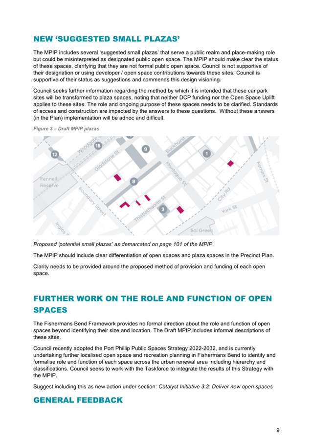
10.3 Council Submission to the Victorian Government's Montague Precinct Implementation Plan (Fishermans Bend).......................................................................................... 227
10.4 Council Submission to the Victorian Government's Fishermans Bend Urban Renewal Area Development Contributions Plan (Planning Scheme Amendment GC224)... 291
10.5 E-scooter Trial Update.................................................................................... 399
11 Sustainable Port Phillip
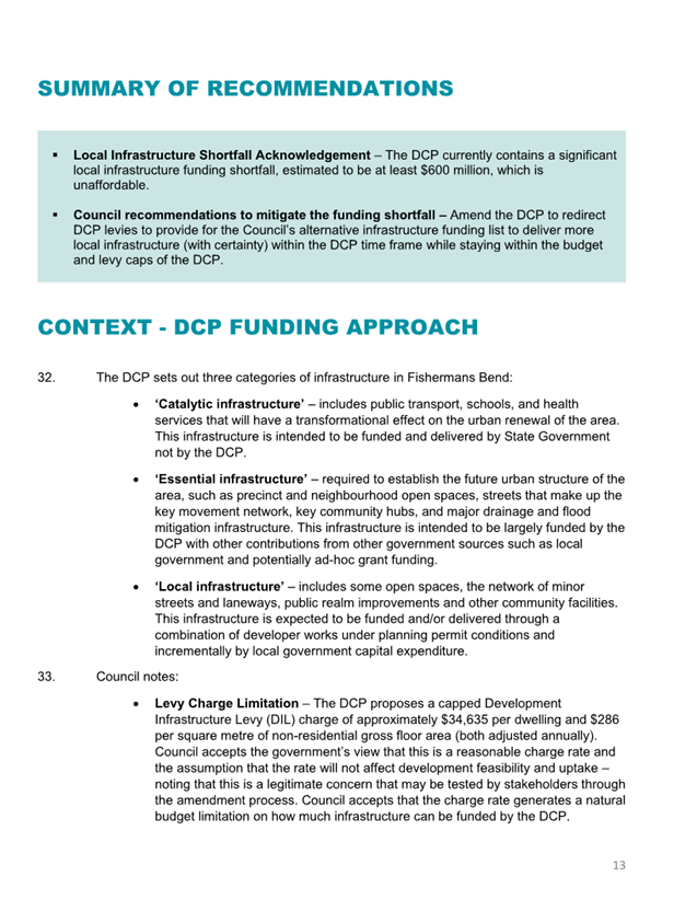
Nil
12 Vibrant Port Phillip
Nil
13 Well Governed Port Phillip
13.1 Proposed Update to Rating Strategy 2022-2025............................................ 409
13.2 Proposed Discontinuance of Road Adjoining 197 and 199 Princes Street, and 55 Station Street, Port Melbourne.................................................................................... 439
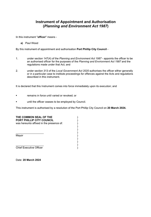
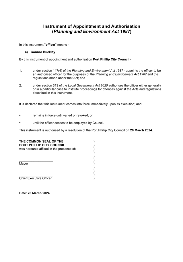
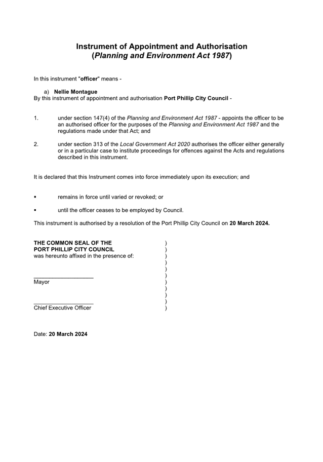
13.3 Appointment of Authorised Officers Pursuant to the Planning and Environment Act 1987 445
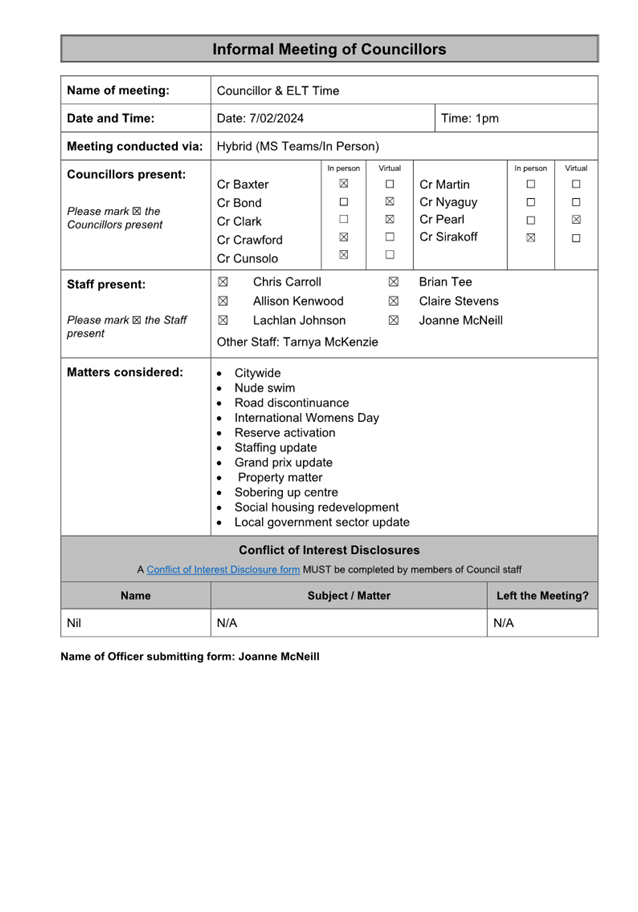
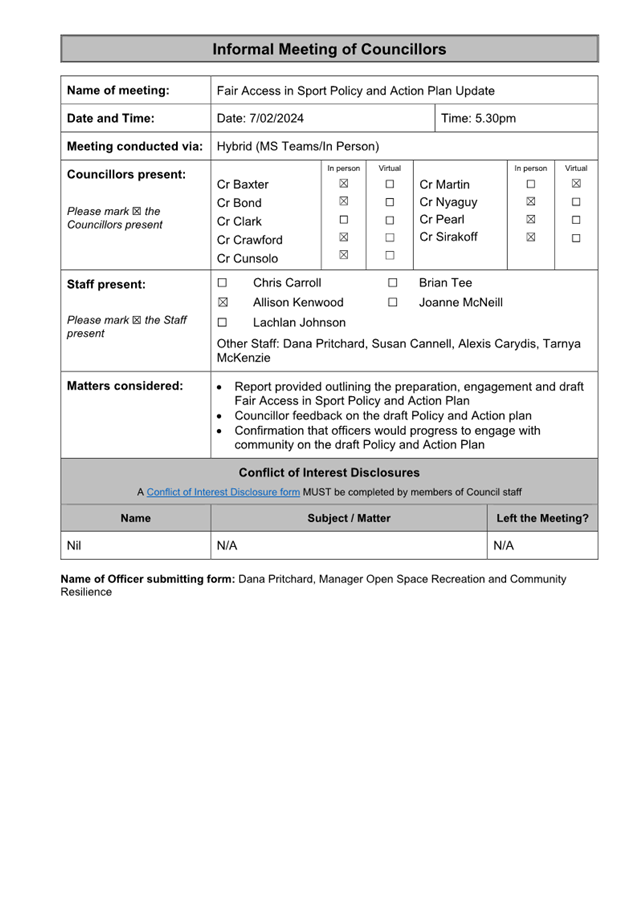
13.4 Records of Informal Meetings of Council........................................................ 453
14 Notices of Motion
14.1 Notice of Motion Councillor Rhonda Clark – Rates Freeze............................ 473
15 Reports by Councillor Delegates
16 URGENT BUSINESS
17 Confidential Matters
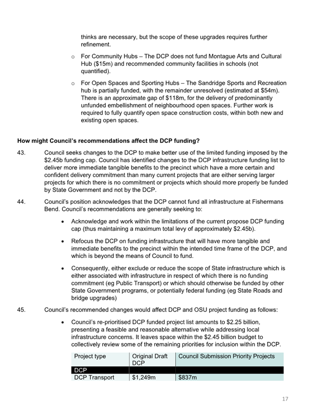
The information contained in the following Council reports is considered to be Confidential Information in accordance with Section 3 of the Local Government Act 2020.
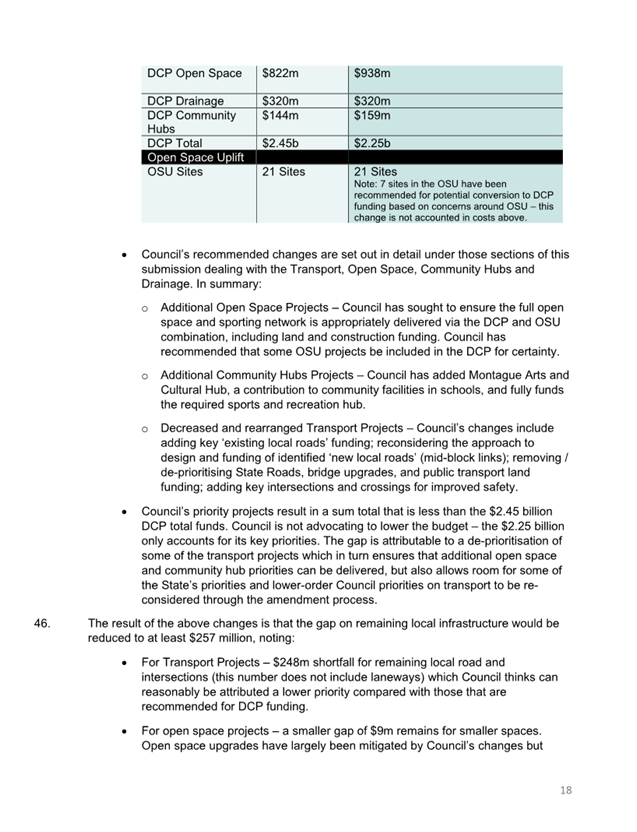
17.1 Independent Waste Review ......................................................................... 475
3(1)(a) Council business information, being information that would prejudice the Council's position in commercial negotiations if prematurely released;
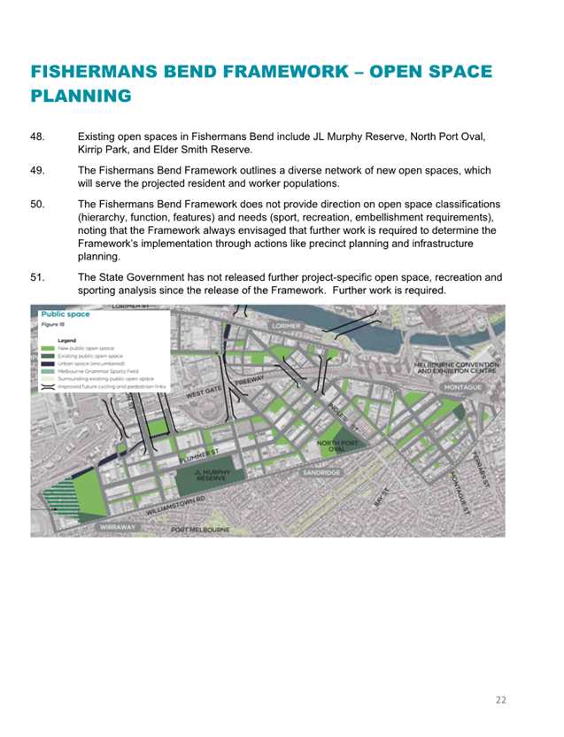
3(1)(e) legal privileged information, being information to which legal professional privilege or client legal privilege applies;
3(1)(g)(ii) private commercial information, being information provided by a business, commercial or financial undertaking that if released, would unreasonably expose the business, commercial or financial undertaking to disadvantage
Reason:
This report will consider commercially and legally sensitive information that could impact Council’s ability to manage an ongoing contract. Council will consider what information is to be released publicly at the 20 March 2024 Council Meeting.
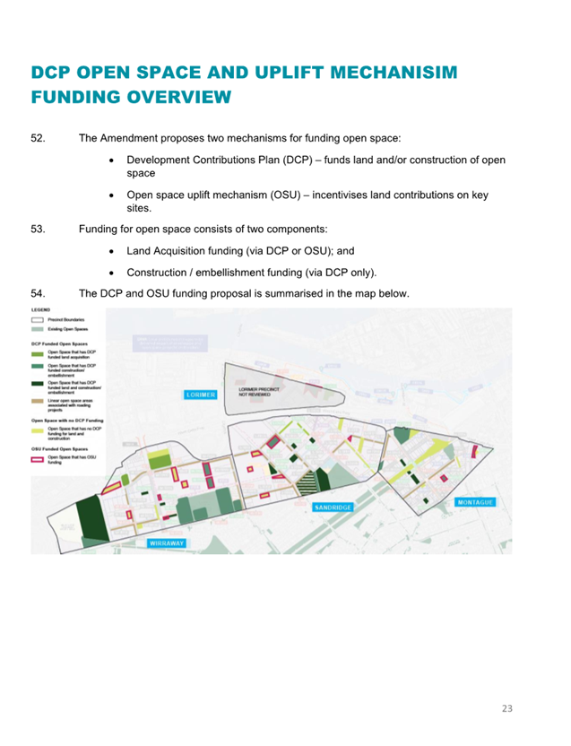
Meeting of the Port Phillip City Council
20 March 2024
3. Declarations of Conflicts of Interest
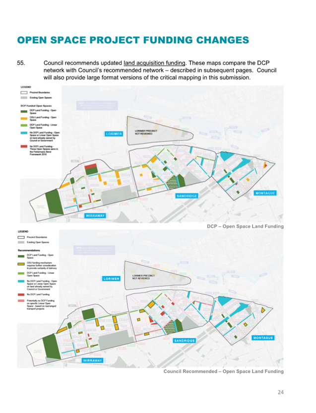
4. Public Question Time and Submissions
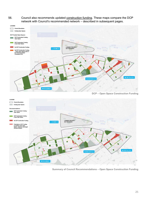
5. Councillor Question Time
6. Sealing Schedule
Nil
7. Petitions and Joint Letters
7.1 Petition - Request extension of Elwood Beach Dog off-lead access................. 6
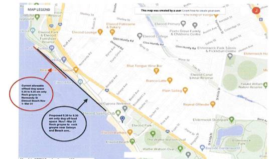
7.1 Petition - Request extension of Elwood Beach Dog off-lead access
A Petition containin 309 signatures, was received from local residents.
The Petition states the following:
We petition the Council to please extend the off-lead space from the current rock Groyne south of Point Ormond, extending to the next rock groyne adjacent to Elwood Angling Club. From 5:30 to 9:30am in the Nov 1 – Mar 31 period.
Supporting Information:
We are the undersigned, local, Elwood residents and rate payers who regularly need off lead space to walk our dogs in a space close to home which is walkable and safe each day. Whilst we love being on the beach in winter during the summer, the current space from the rock Groyne (near Ormond Point) to Normandy Rd is less than a 5 min walk. And we only have access until 9:30am in the mornings.
Whilst 99% of the foot traffic on Elwood beach is on the footpath above the beach very few people walk on the sand or use it prior to 9:30am except for people walking their dogs.
We also request that this area be clearly signed as the current lack of clear signage causes confusion and angst amongst the community.
We thank you for your consideration and look forward to a positive response.
|
That Council: 1. Receives and notes the Petition and provides a response to a future Council meeting. |
|
ATTACHMENTS |
Nil |
Meeting of the Port Phillip City Council
20 March 2024
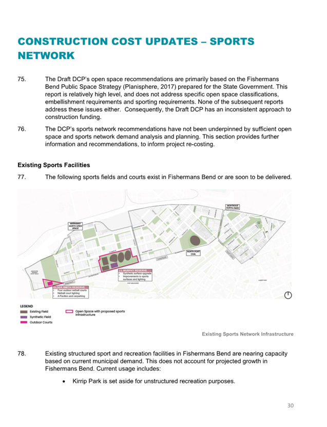
8. Presentation of CEO Report
Nil
9. Inclusive Port Phillip
Nil
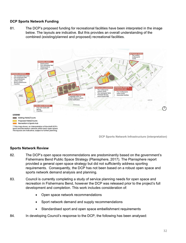
10.1 Inkerman Safety Improvement Project - Engagement Findings....................... 15
10.2 Draft Dog Off-Leash Guideline for Public Consultation.................................. 219
10.3 Council Submission to the Victorian Government's Montague Precinct Implementation Plan (Fishermans Bend)................................................................................. 235
10.4 Council Submission to the Victorian Government's Fishermans Bend Urban Renewal Area Development Contributions Plan (Planning Scheme Amendment GC224) 301
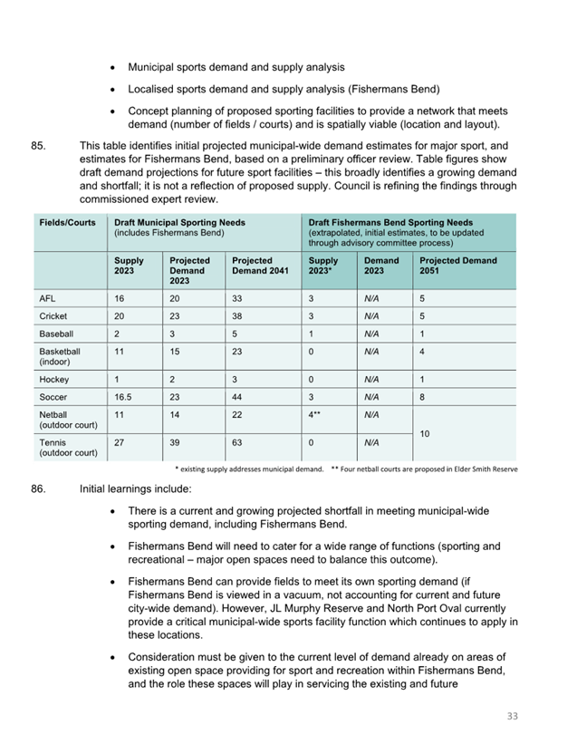
10.5 E-scooter Trial Update.................................................................................... 409
Meeting of the Port Phillip City Council
20 March 2024
|
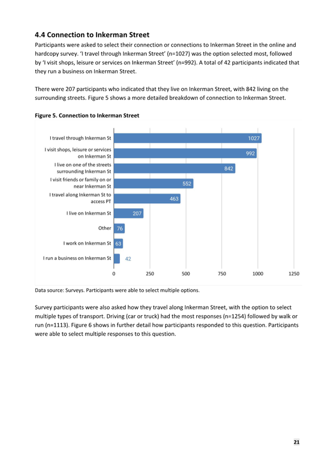
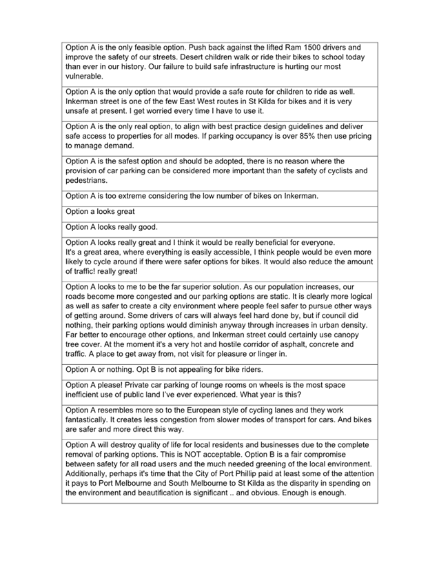
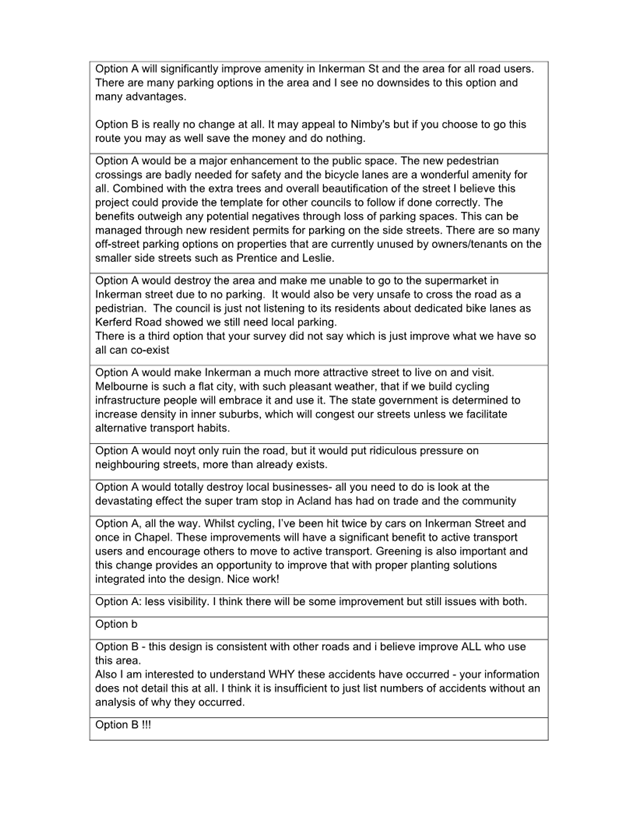
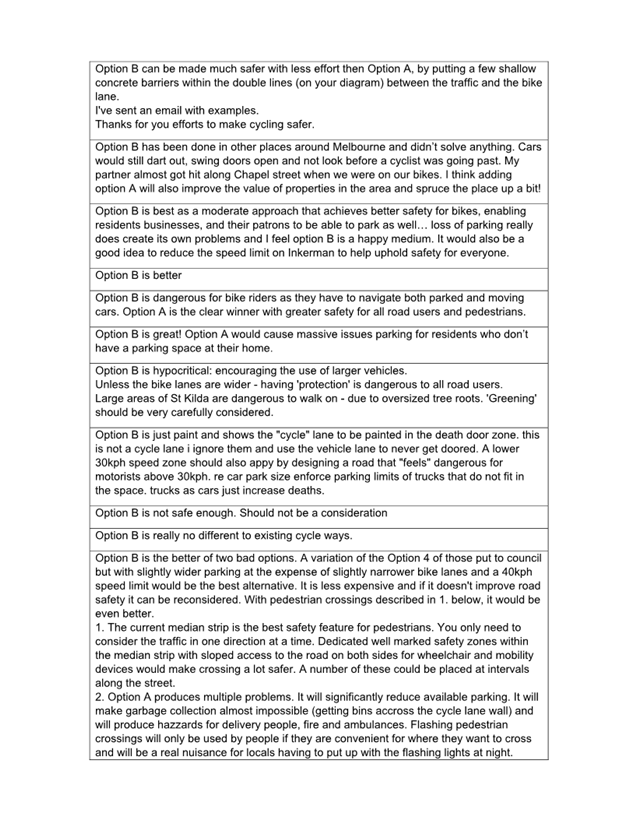
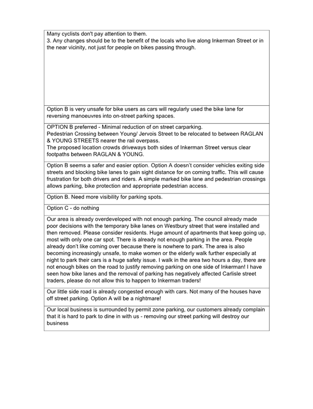
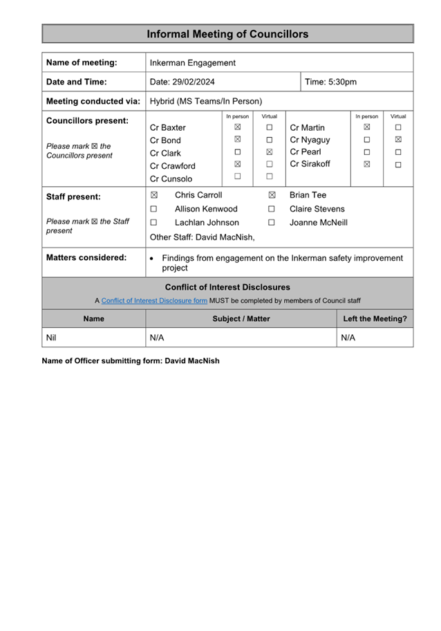
Inkerman Safety Improvement Project - Engagement Findings |
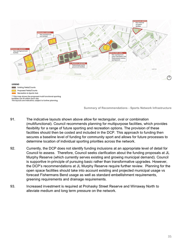
|
|
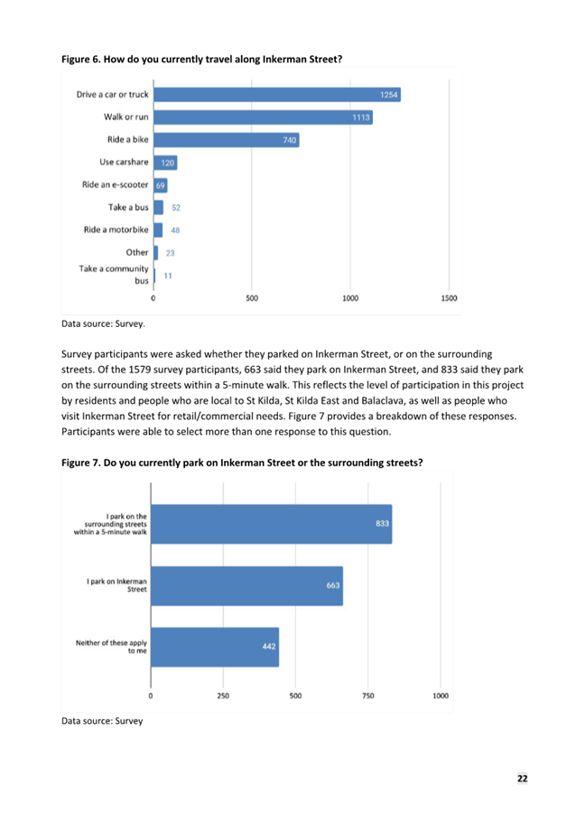
Executive Member: |
Brian Tee, General Manager, City Growth and Development |
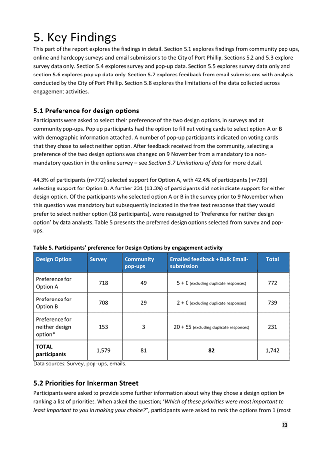
|
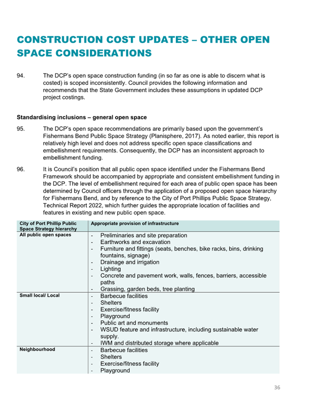
PREPARED BY: |
David MacNish, Head Major Transport Projects - Domain Precinct Chris Tsiafidis, Senior Transport Engineer |
1. PURPOSE
1.1 To
present the findings of the community engagement on the Inkerman Safety
Improvement Project (the Project). A subsequent Council meeting will consider
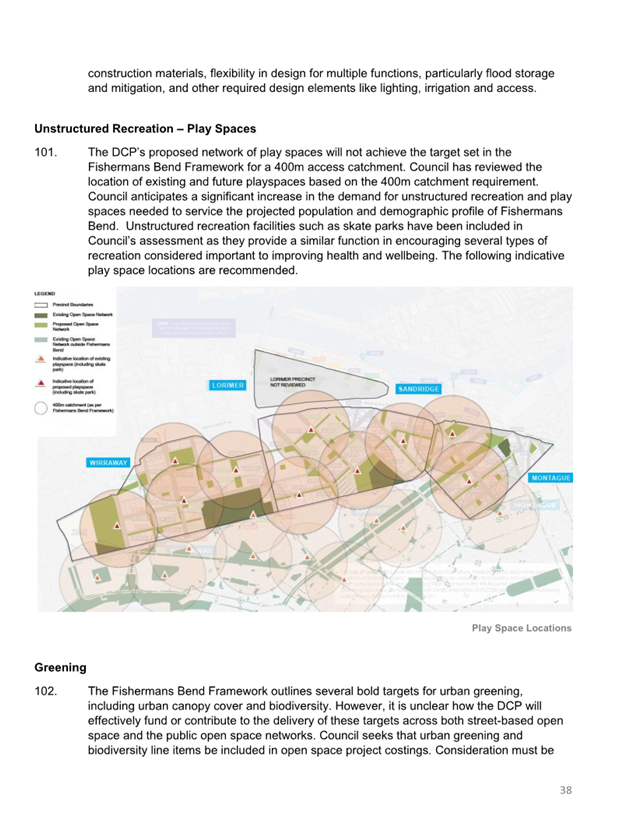
recommended options for proceeding with the project.![]()
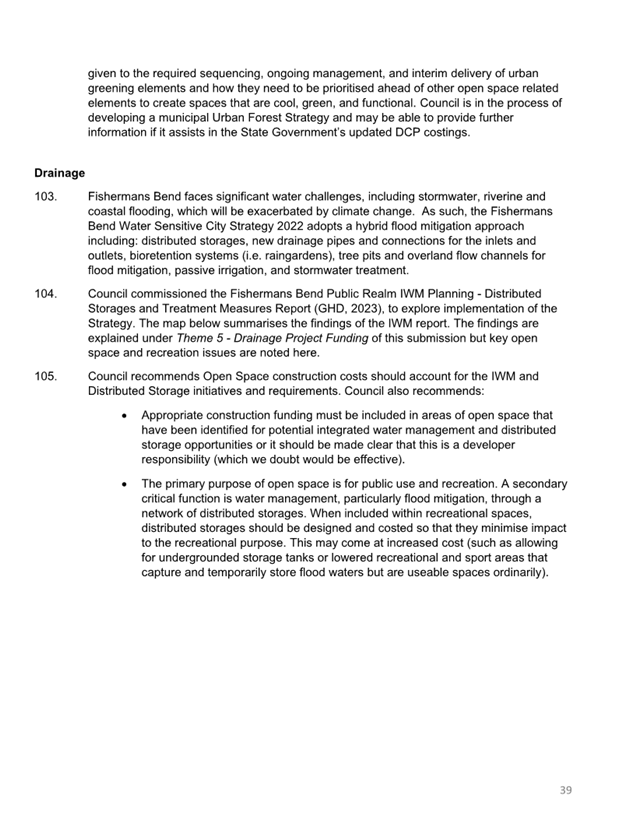
2. EXECUTIVE Summary
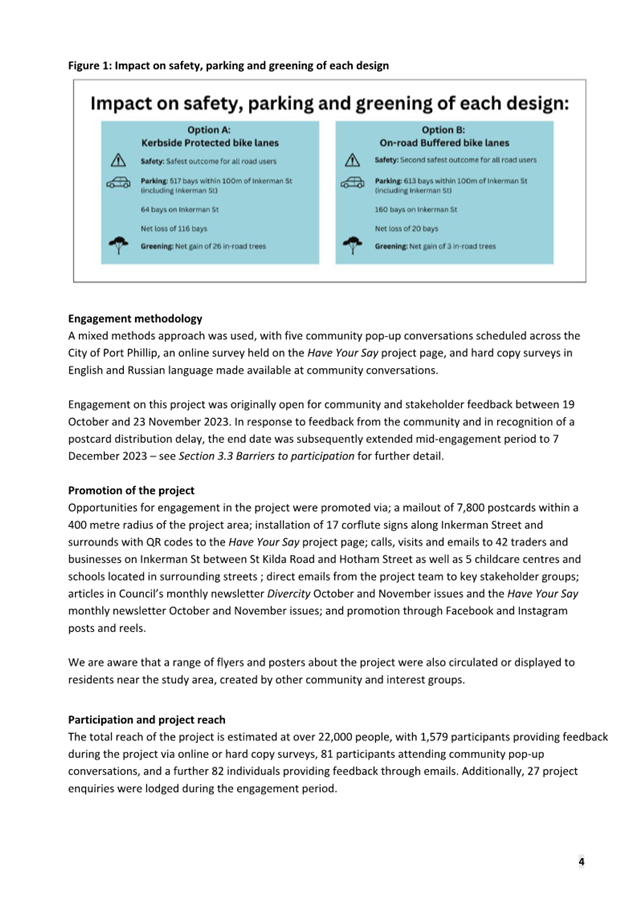
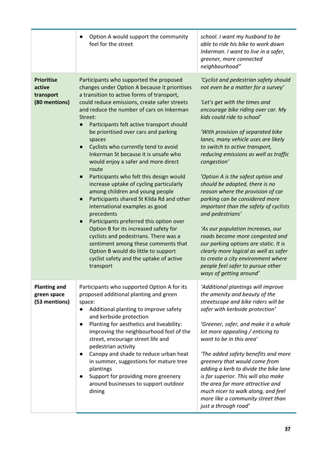
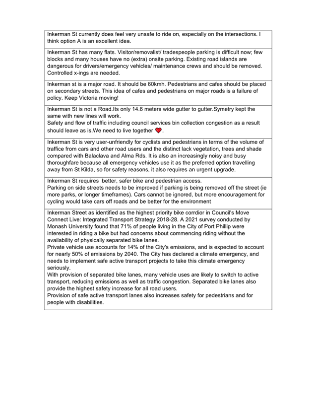
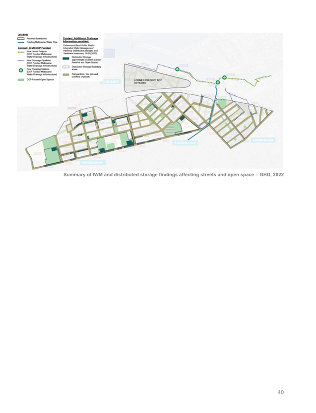
2.1 The Inkerman Safe Travel Corridor project was identified as the highest priority bike corridor in Council’s Move Connect Live: Integrated Transport Strategy 2018-28. The strategy identifies Inkerman Street as requiring a protected bike lane from St Kilda Road to Hotham Street.
2.2 At the 5 May 2021 Council Meeting, Council endorsed the development of three concept designs. Following the May 2021 decision and prior to undertaking Community Engagement, officers undertook three briefings with Councillors (8.03.23, 10.05.23 & 27.09.23).
2.3 At the 8 March 2023 briefing, Officers were requested to investigate a fourth ‘do minimum’ option and explore ways to reduce parking impacts in each design option.
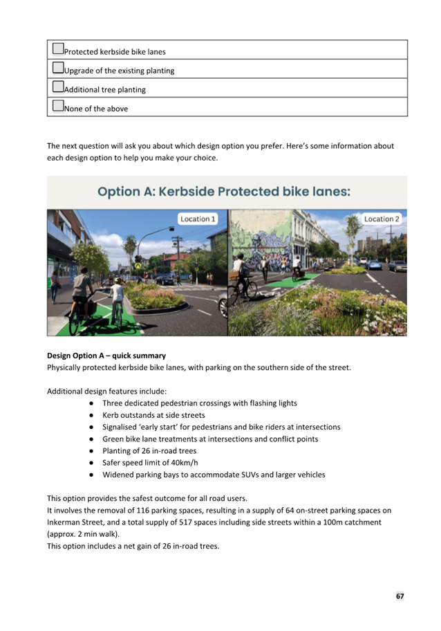
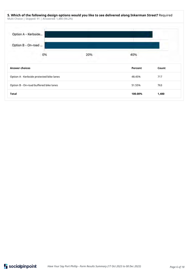
2.4 At the 18 October 2023 Council meeting the four concept designs were presented. Council agreed to release the following two concept design options for community engagement:
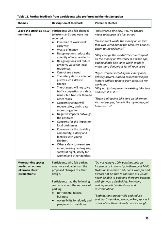
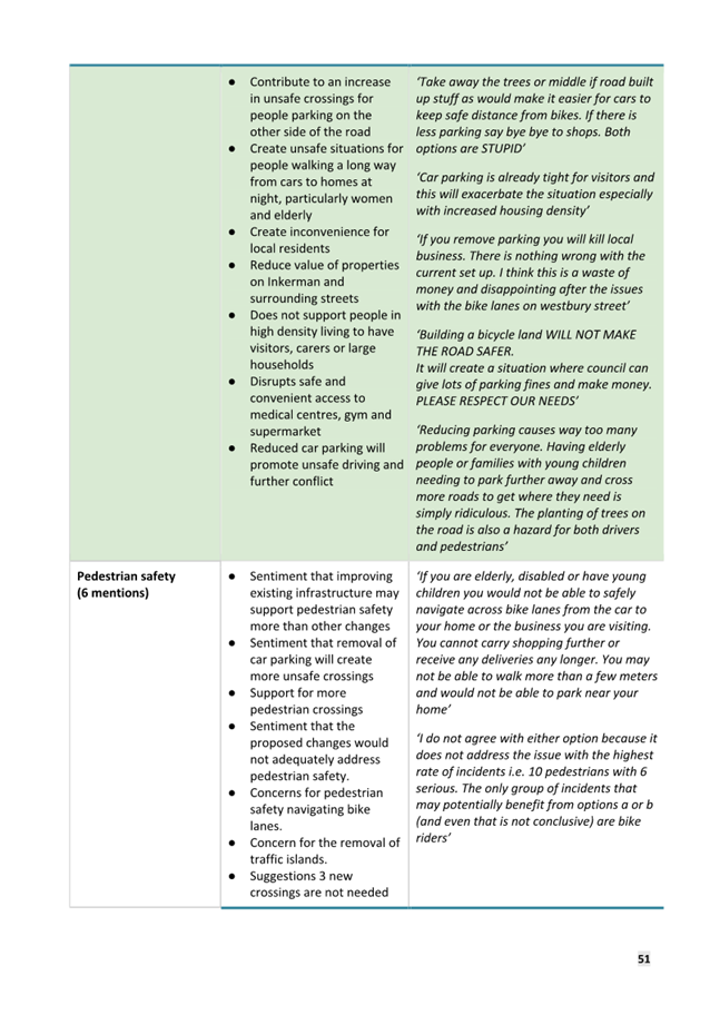
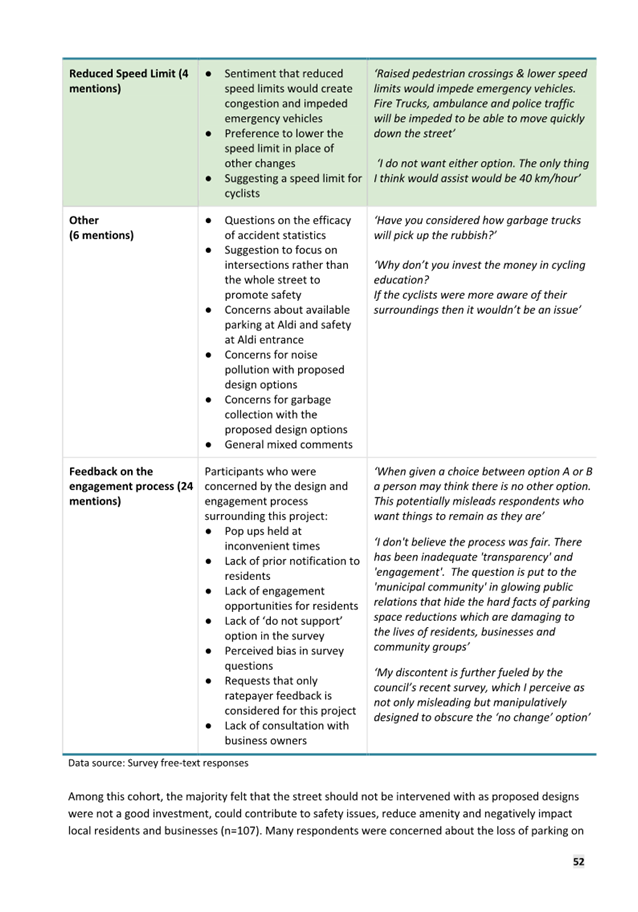
· Option A: Safety improvements including a kerbside protected bike lanes.
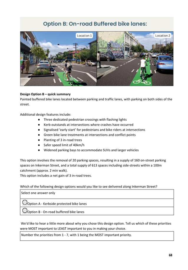
· Option B: Safety improvements including on-road buffered bike lanes
2.5 Community engagement took place over seven weeks (19 October to 7 December 2023). The seven-week engagement period was inclusive of a two-week extension, following concerns from residents at the 1 November 2023 Council meeting that some residents had not yet received the project flyer and may not be aware of the project.
2.6 Information regarding the engagement was provided on corflute signs along the length of Inkerman Street with postcards mailed to all owners and occupiers of properties within 400 metres of the study area. An additional letter-drop was undertaken following the concerns raised at the November meeting.
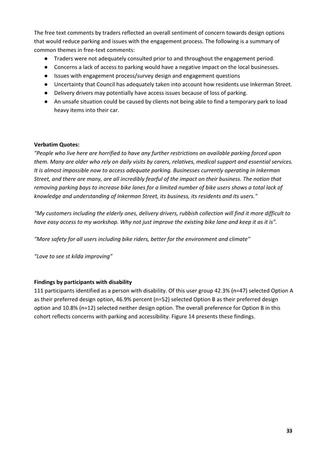
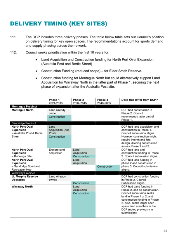
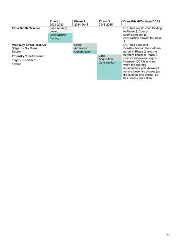
2.7 Council relied on multiple avenues to inform the community of the project including social media posts which reached approximately 22,000 people, inclusion in Council newsletters and electronic mailouts, face-to-face and direct emailing to businesses and completion of four pop-up information sessions along Inkerman Street.
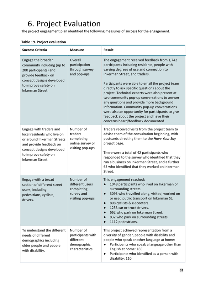
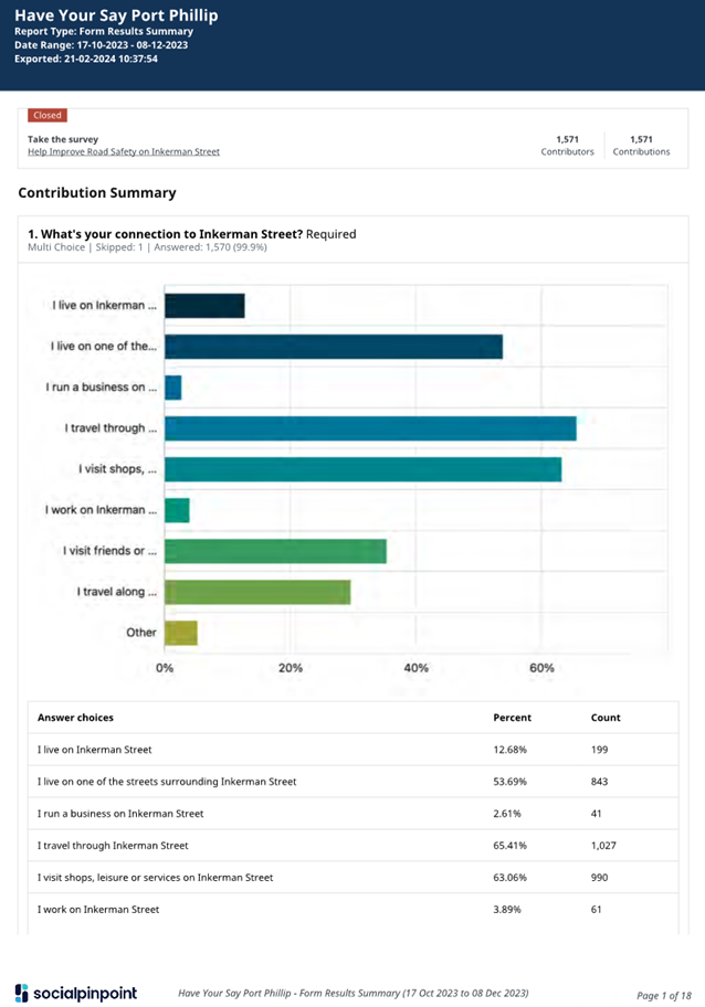
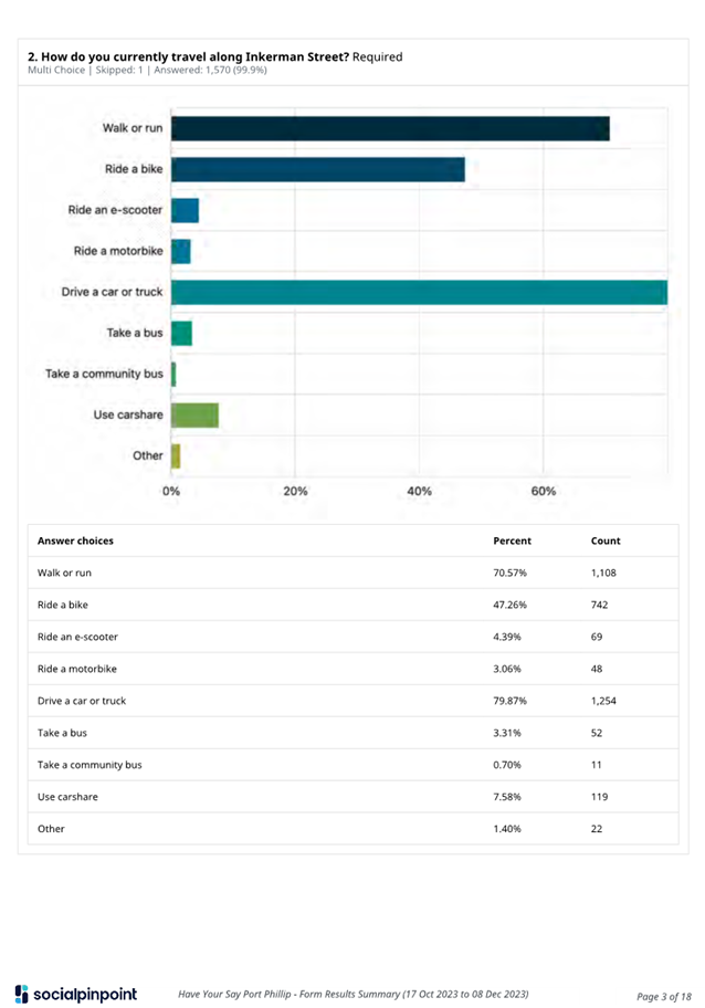
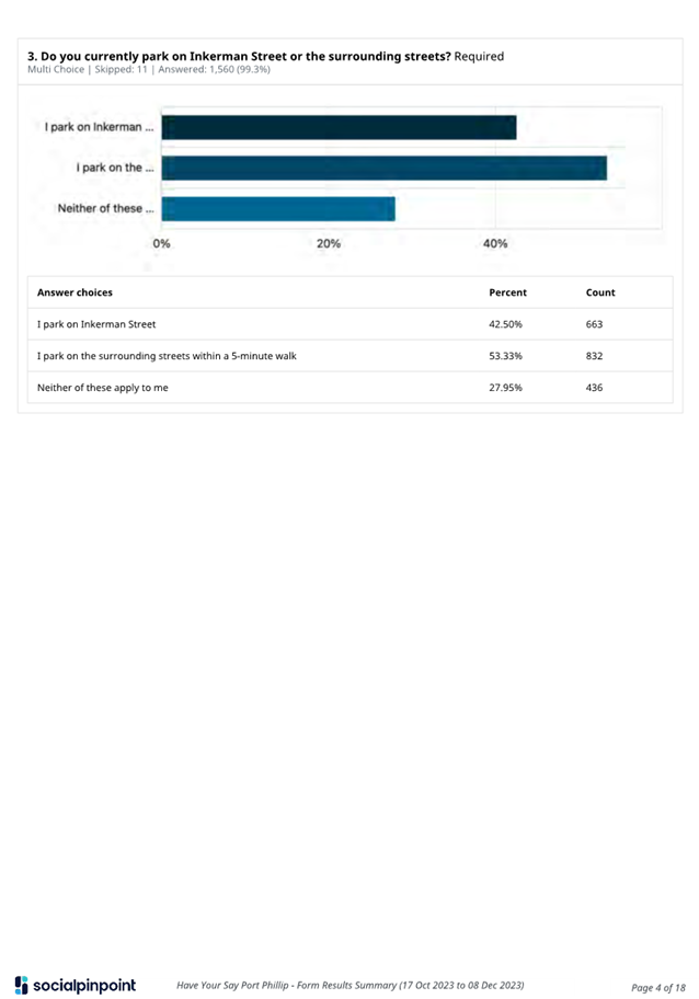
2.8 There were 1,579 participants providing feedback during the project consultation period via online or hard copy surveys. The majority of respondents were from the suburbs where the project is located.
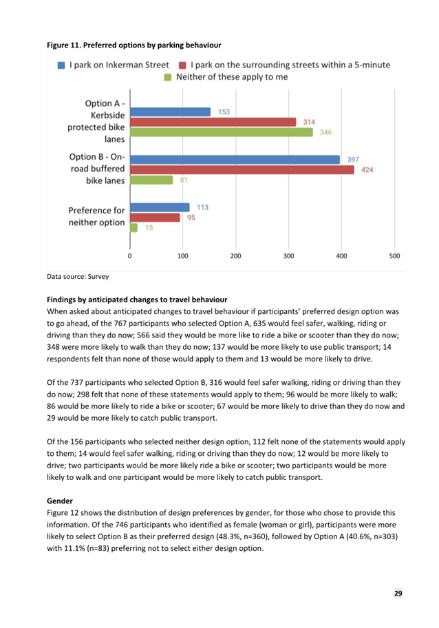
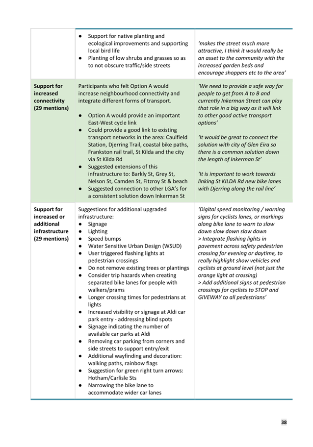
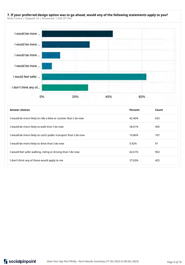
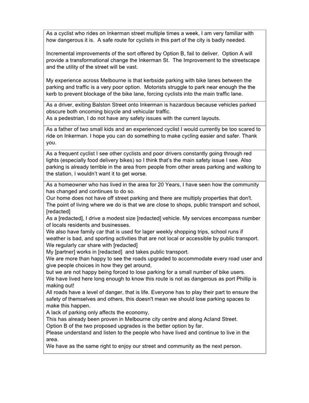
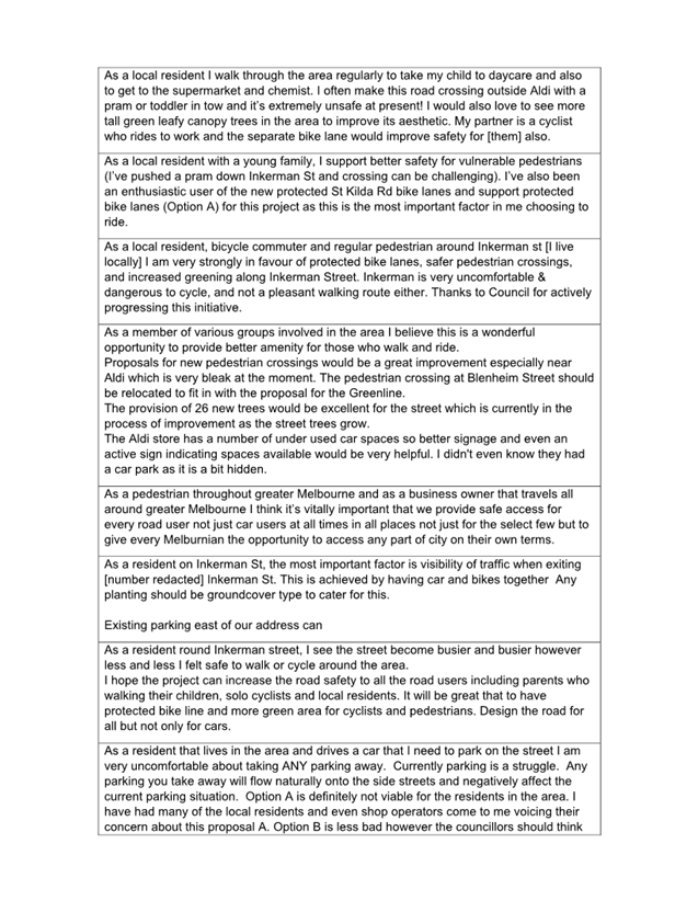
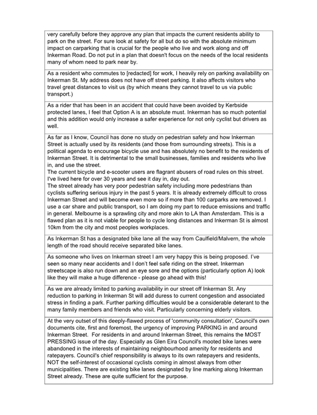
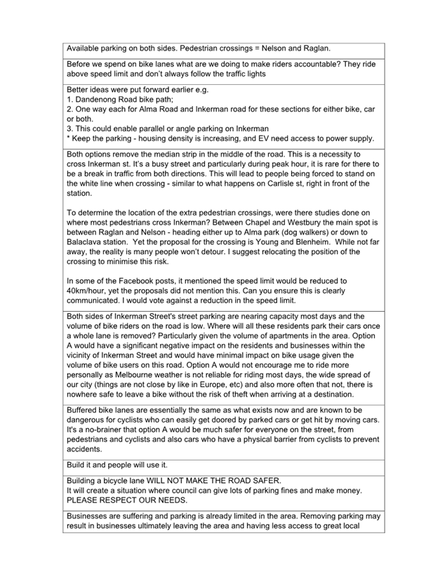
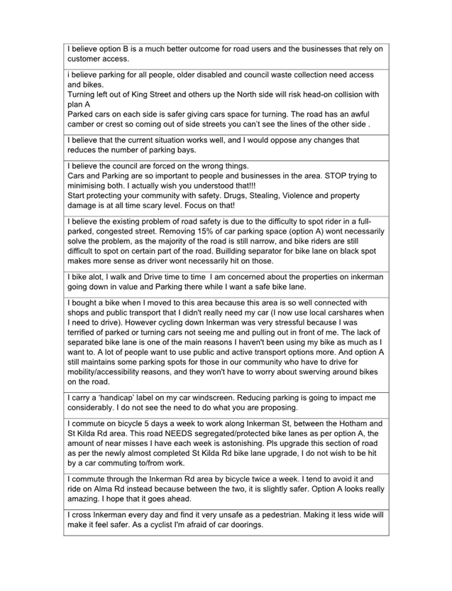
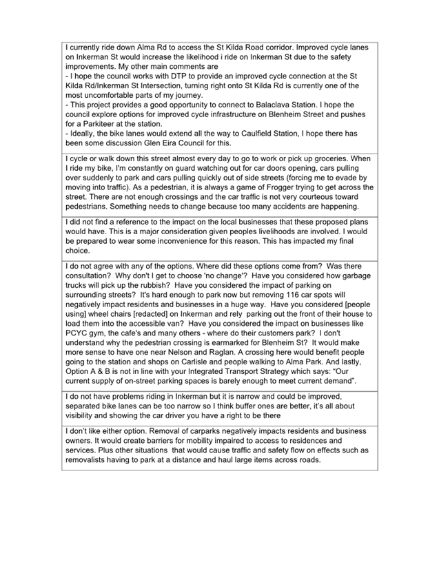
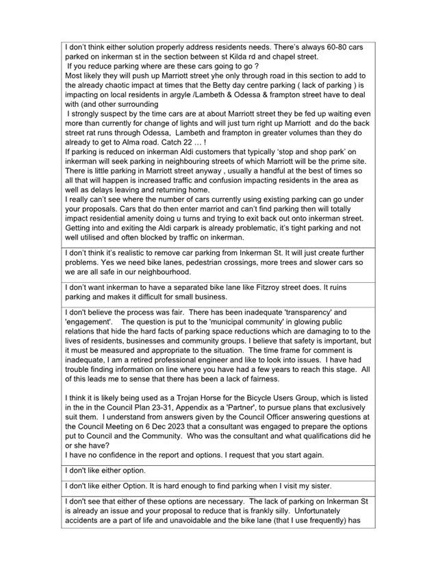
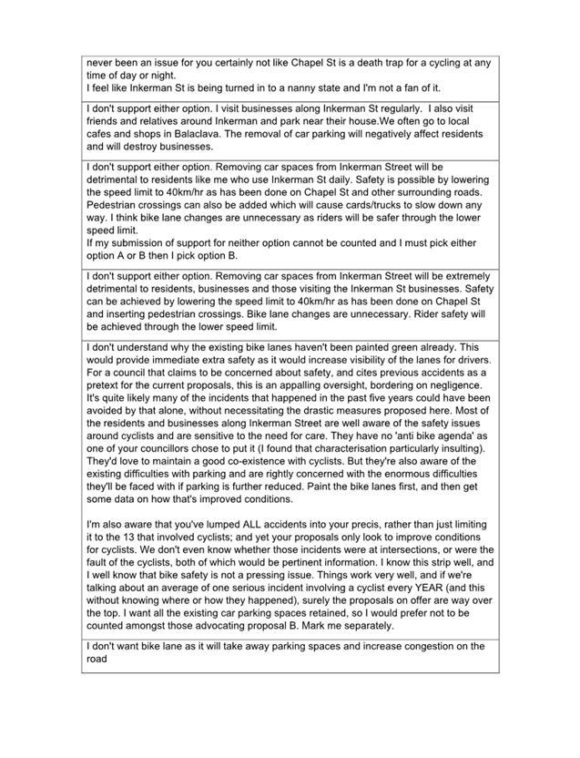
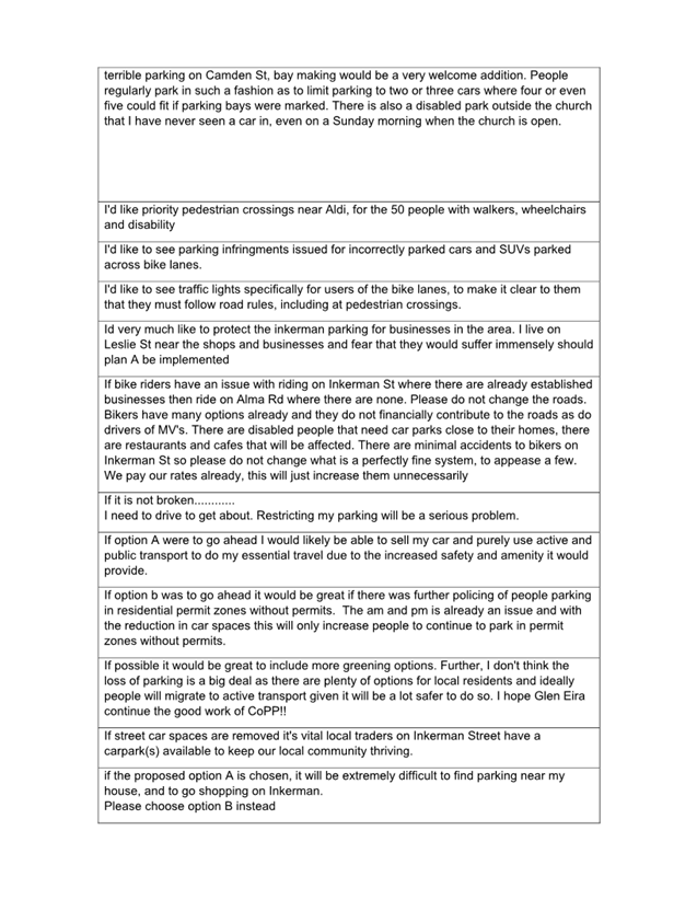
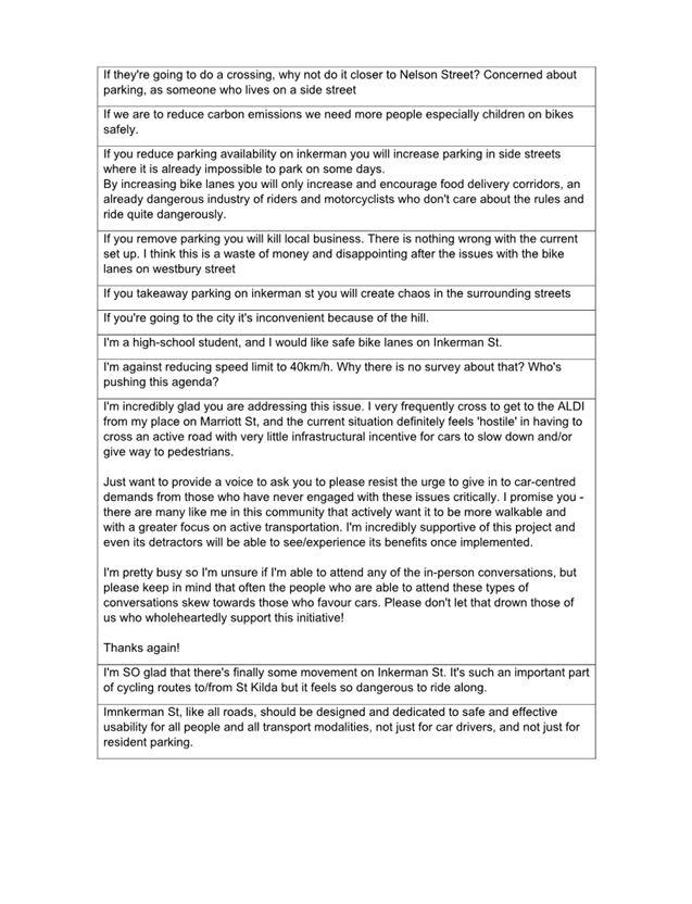
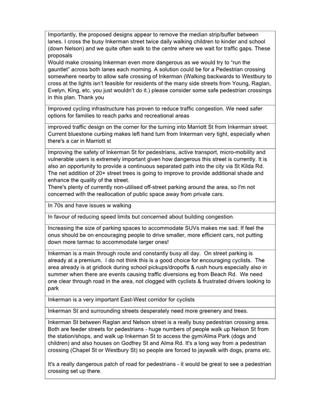
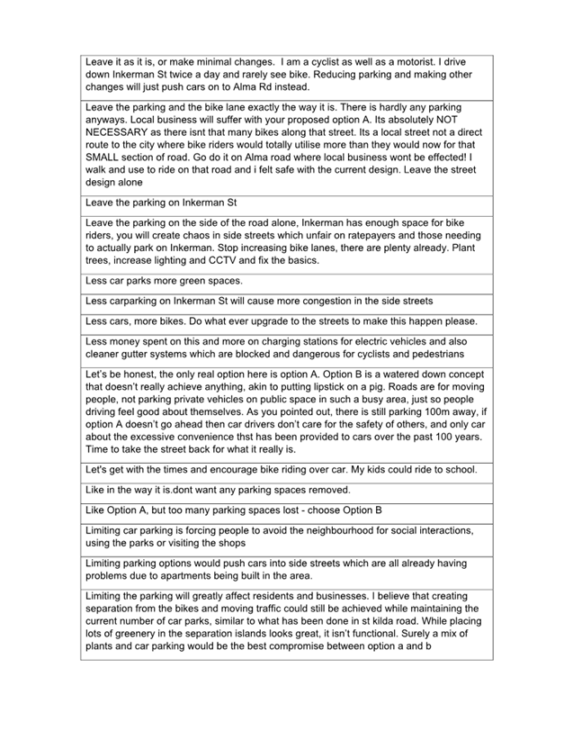
2.9 Key themes from the engagement include support for increasing safety for all road users, providing safer and more inclusive riding options, providing more inclusive crossing options, the loss of on-street parking and negative impacts of reduced parking on residents and businesses and access to disabled bays.
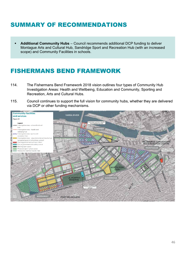
2.10 The Engagement Summary Report is in Attachment 1. The Have Your Say (HYS) ‘Survey Response Overview’ including open text comments are in Attachment 2.
2.11 In December 2023, when reviewing location information on crash statistics, Officers identified an issue in Section 4.6 of the 18 October 2023 Council Report. The report referred to 33 crashes along Inkerman Street between St Kilda Road and Hotham Street. The review found that six crashes were incorrectly included that were outside of the project boundary and four crashes were incorrectly excluded that were inside the project boundary. In summary, the total recorded crashes are 31 and not 33 as per the October report. This update has been provided to Councillors and community members who sought additional information on crash statistics. In addition, the project page has been updated and an update has been emailed to those that signed up for updates on the project though HYS. The summary was provided to Councillors in December.
2.12 At a future Council Meeting, Council will be presented with a report that will include project recommendations.
|
That Council: 3.1 Thanks community members who provided feedback on the Inkerman Safety Improvement Project. 3.2 Notes the high level of interest from community and businesses and varied views as outlined in the Engagement Summary Report (Attachment 1). 3.3 Requests a subsequent report be tabled at an ordinary Council meeting in 2024 for Council to determine any design changes to the Inkerman Safety Improvement Project and whether to progress to detailed design and construction. |
4. KEY POINTS/ISSUES
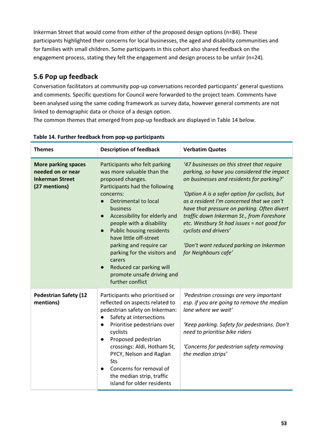
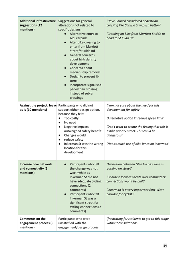
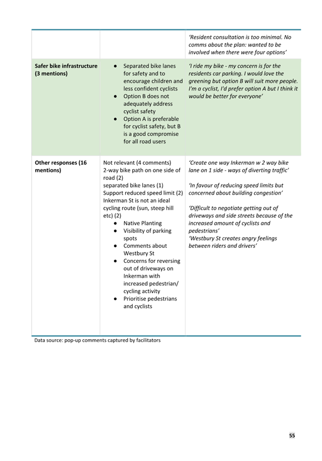
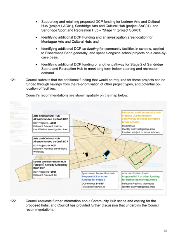
BACKGROUND
4.1 The Inkerman Safety Improvement Project proposes treatments to Inkerman Street between St Kilda Road and Hotham Street (Figure 1).
4.2 Inkerman Street is at the end of life and is due for re-sheeting. This will require removal of the existing painted bike lanes. Council has been considering options for the redesign of Inkerman Street that will improve safety and amenity outcomes.
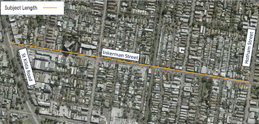
Figure 1. Map of Inkerman Safe Travel Corridor site
4.3 Inkerman Street has a high number of recorded crashes compared to other Council-managed roads.
4.4 At the 5 May 2021 Council Meeting, Council endorsed the development of three concept designs for the Inkerman Safe Travel Corridor Project to be presented at a future Council meeting for consideration for release for community engagement.
4.5 The project objectives agreed at the 2021 Council meeting were to:
· Improve safety for all road users and attract a broader range of people of all ages and abilities to ride a bike.
· Increase travel choices by providing a safe alternative to public transport and cars.
· Minimise and mitigate parking loss and maximise tree retention.
4.6 In the 8 May 2023 project briefing, Councillors requested investigation of a fourth ‘do minimum’ option as well as to explore ways to reduce parking impacts in each option.
4.7 At the 18 October 2023 Council meeting the resulting four concept designs were presented to determine which options were to be released for community engagement.
4.8 Councillors voted unanimously to support the following motion (Councillor Pearl was not in attendance).
That Council:
3.1 Endorses the release of the draft concept designs Option 1 and Option 3 for the Inkerman Safety Improvement Project Corridor for community engagement.
3.2 Requests officers to investigate if parking can be added to or reconfigured on streets nearby to Inkerman Street to offset any loss of parking spaces from Inkerman Street.
3.3 Requests a subsequent report be tabled at an ordinary Council meeting, as soon as practicable in 2024, for Council to consider the results of the community engagement and to present any findings from the work detailed in point 3.2, and to determine whether to progress the project to detailed design and construction.
ENGAGEMENT DESIGN OPTIONS
4.9 The two options endorsed by Council for release for community feedback are as follows:
Option A: Safety improvements including a kerbside protected bike lanes
This option includes a physically protected, wide (2.2m) kerbside bike lanes with buffered parking on one side of the road, three dedicated pedestrian crossings with flashing lights, kerb outstands at side streets and safety improvements at signalised intersections.
Option B: Safety improvements including on-road buffered bike lanes
This option included on-road painted bike lanes located between parking and traffic lanes, with painted buffers on either side, parking on both sides of the road (reduced parking offsets from driveways), three dedicated pedestrian crossings with flashing lights, kerb outstands at side streets where crashes have occurred and safety improvements at signalised intersections.
5. CONSULTATION AND STAKEHOLDERS
5.1 At the Council Meeting on 18 October 2023, Council considered four design options for the Inkerman Street Safety Improvement Project and endorsed two options for community engagement.
5.2 Community engagement occurred over a seven-week period (19 October – 7 December 2023) and included:
· 16x corflute project posters along the length of the project area, with QR codes linking to further information, to inform regular users of Inkerman Street about the engagement
· 7,800 postcards letter-dropped flyers to owners, residents and businesses within a 400-metre radius of the project area
· A separate letter-drop following the postcards in response to concerns that some residents had not received the initial postcard
· Posts on Council’s Facebook and Instagram social media accounts boosted through a targeted social media campaign for the duration of the engagement period
· Inclusion in Council’s Diversity e-news, local media and HYS newsletter
· Four, two-hour pop-up information sessions along Inkerman Steet
· Inclusion in the Neighbourhood Engagement Program pop-up on Carlisle Street
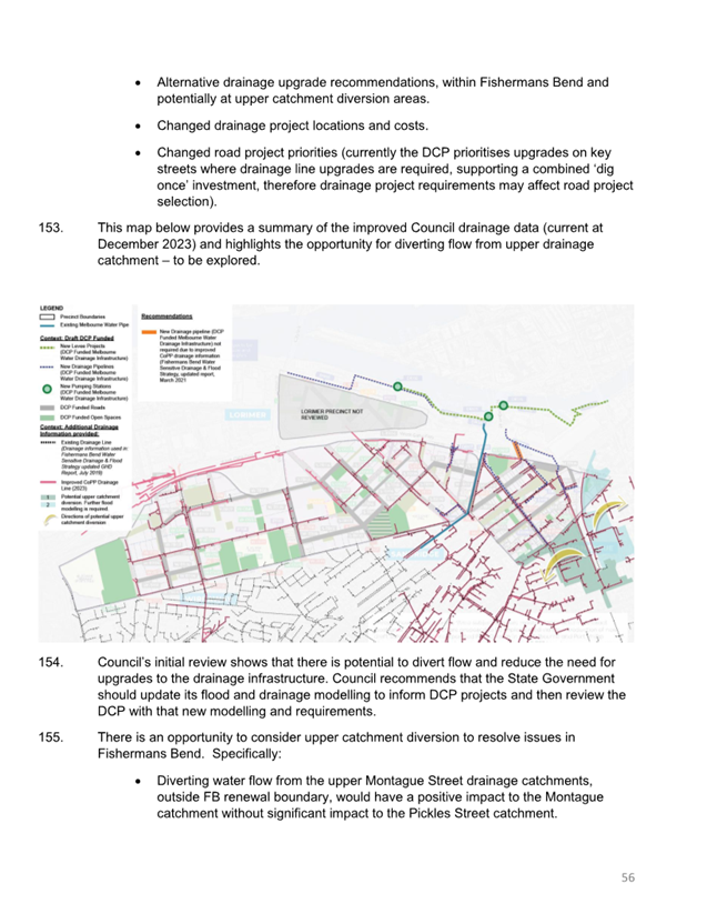
· HYS survey, with ability to provide open comments and written submissions on the proposal
· Online and hard copy surveys
· Direct contact with business with commercial tenancies in the project area, including an initial drop-by with project handout, responding to project queries and HYS email reminders
· Following the conclusion of the community engagement, officers have undertaken interviews with business owners / managers with commercial tenancies on Inkerman Street
COMMUNITY REACH AND PARTICIPATION
5.3 The total reach is estimated at over 22,000 people, specifically social media insight statistics.
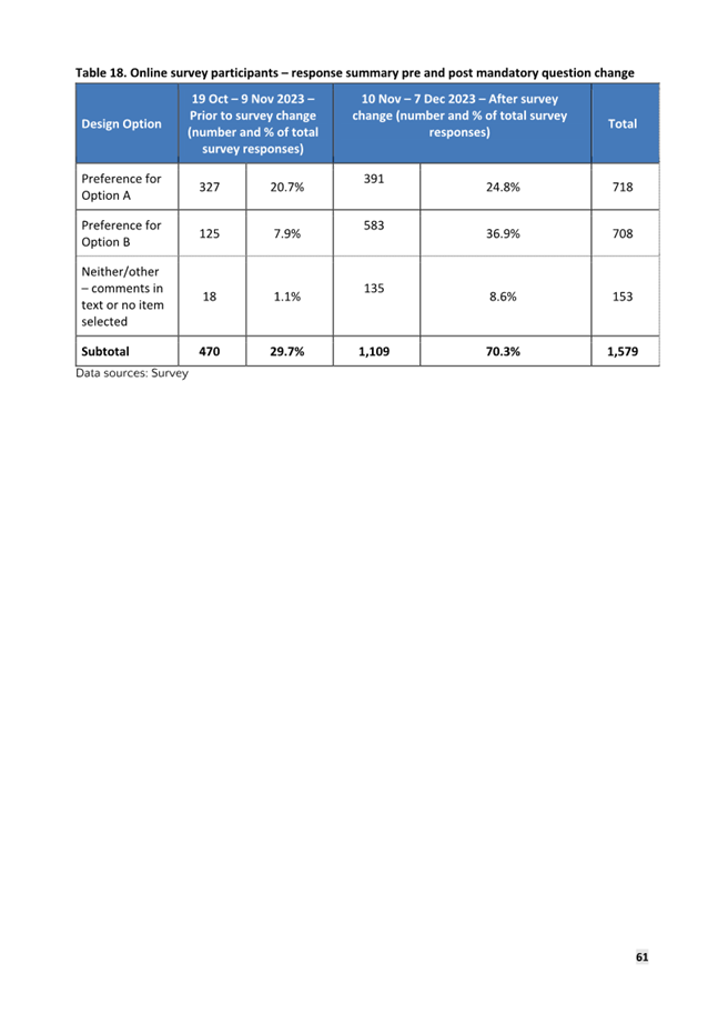
5.4 Council received 1,579 HYS survey responses (online or hard copy).
5.5 The majority of the survey participants were residents of the surrounding area, with 1,048 identifying that they live on Inkerman Street or surrounding streets.
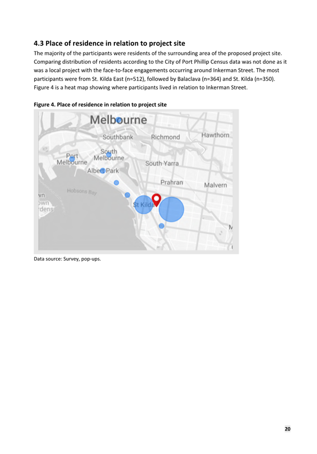
5.6 Where respondents identified their suburb, the top three suburbs represented were St. Kilda East (511), Balaclava (364) and St. Kilda (350), making up 77.6% of all respondents. The project area is contained wholly within these three suburbs.
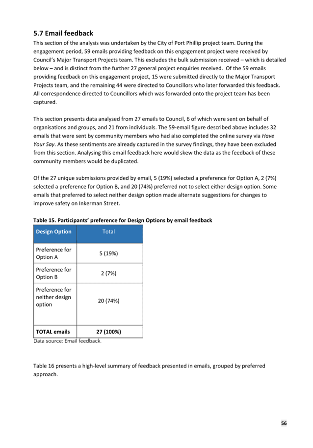
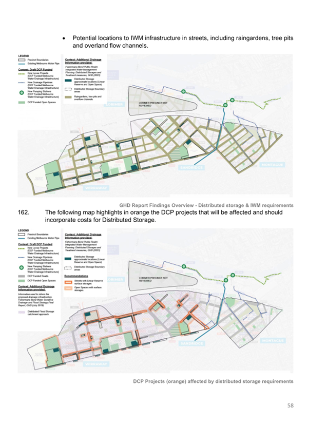
5.7 In addition to the Have You Say Survey feedback:
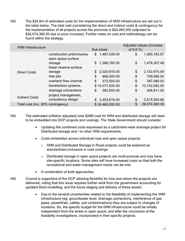
· 81 community members attended community pop-up sessions, seeking information, clarifications and providing feedback on the project.
· 61 individuals provided feedback through emails, either directly to the project team or through emails forwarded by Councillors (32 of these community members also participated in the HYS survey).
· 27 project enquiries were lodged during the engagement period.
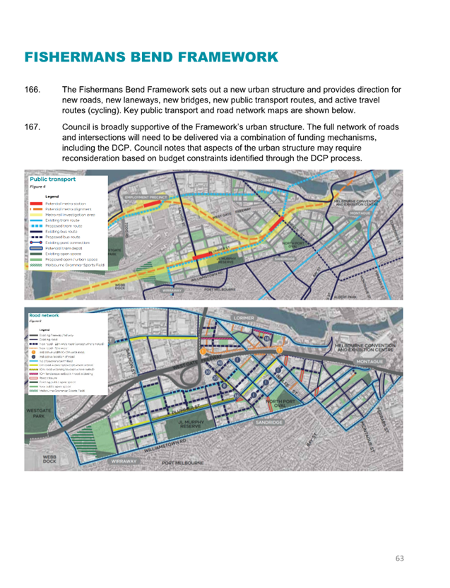
· Council also received a ‘bulk email-submission’ from an individual, accompanied by an executed Statutory Declaration. The Statutory Declaration stated that the individual had legal authority to represent and provide a project response on behalf of the individuals listed in the document. A review of the submission identified 55 unique individual responses. The bulk submission is included in the engagement report and overall project response numbers.
OVERVIEW OF BUSINESS SPECIFIC FEEDBACK
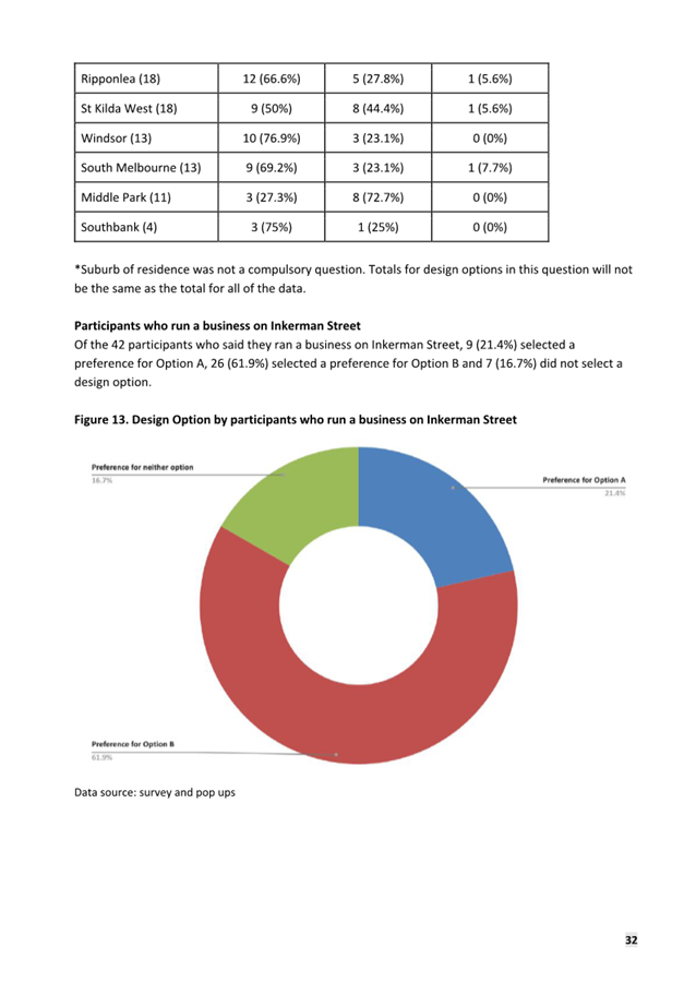
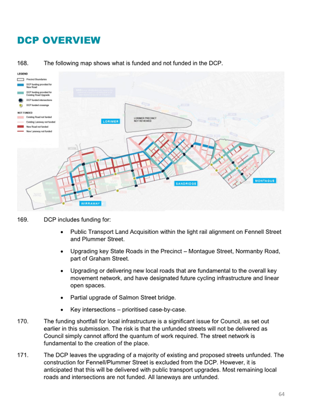
5.8 Council records indicate 43 businesses with a commercial tenancy are located along Inkerman Street between St Kilda Road and Hotham Street. Council received 42 individual HYS survey responses where the respondent identified themselves as running a business on Inkerman Street.
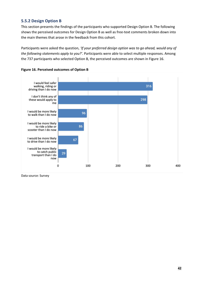
5.9 HYS survey responses from businesses showed a clear preference for Option B over Option A. Results were as follows; 9 (21.4%) selected a preference for Option A, 26 (61.9%) selected a preference for Option B and 7 (16.7%) preferred neither design option.
5.10 The primary concern received through the survey related to parking reduction, particularly in relation to Option A. Open text commentary focused on reduced access to parking for customers, challenges for deliveries and potential negative impacts on businesses.
5.11 Several businesses identified that disabled access was critical to their business while others stated that they provide a specialist service to parts of the community, and that some customers need to drive to Inkerman Street as they do not have alternate options.
5.12 In January 2024, officers contacted all businesses that operate commercial tenancies along Inkerman Street by email and telephone. Where responses or call backs were not received, where possible, officers attended the premises in person to organise a time to meet. The meetings were to better understand how businesses and their customers utilise existing street parking and how any adverse impacts of the project could be ameliorated.
5.13 Officers interviewed 36 businesses. The key findings from the interviews are summarised below and are being considered as part of the design response being prepared for Council. Businesses were concerned about the loss of parking, some businesses raised changes to parking restrictions that would increase availability for customers. Specifically:
· Eight of the businesses interviewed proposed changes to their current parking restrictions including wanting a range of time limits, aligned with business needs. While requirements proposed varied, there is generally a preference for shorter periods between 15 minutes to 1 hour.
· Businesses that trade on weekends identified a preference for some weekend restrictions during hours of trade.
· Four businesses identified use of skip-bins for waste with private collection.
· Most deliveries are undertaken using small vans, these often use side streets for un-loading.
· Some businesses would like to see DDA bays for customers.
· Some businesses identified that they had many elderly or vulnerable customers and that parking near their business was critical.
· Some businesses identified a preference for the pedestrian crossing to be relocated to Nelson Street.
· Most businesses commented that parking reduction would have an adverse impact on their business.
COMMUNITY ENGAGEMENT - KEY FINDINGS
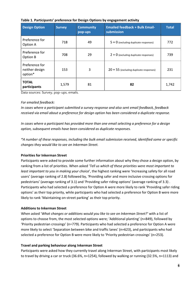
5.14 A summary of the key findings from the Engagement Summary Report (Attachment 1) are outlined below.
5.15 The data includes responses received during the engagement period including, HYS, pop-up surveys, project emails (excluding those who provided a HYS response) and the bulk email-submission.
|
Overall Responses |
||
|
Design Option |
Total No. |
Total % |
|
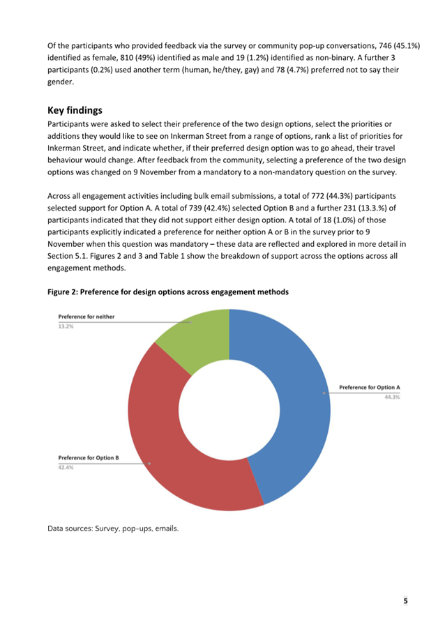
Option A |
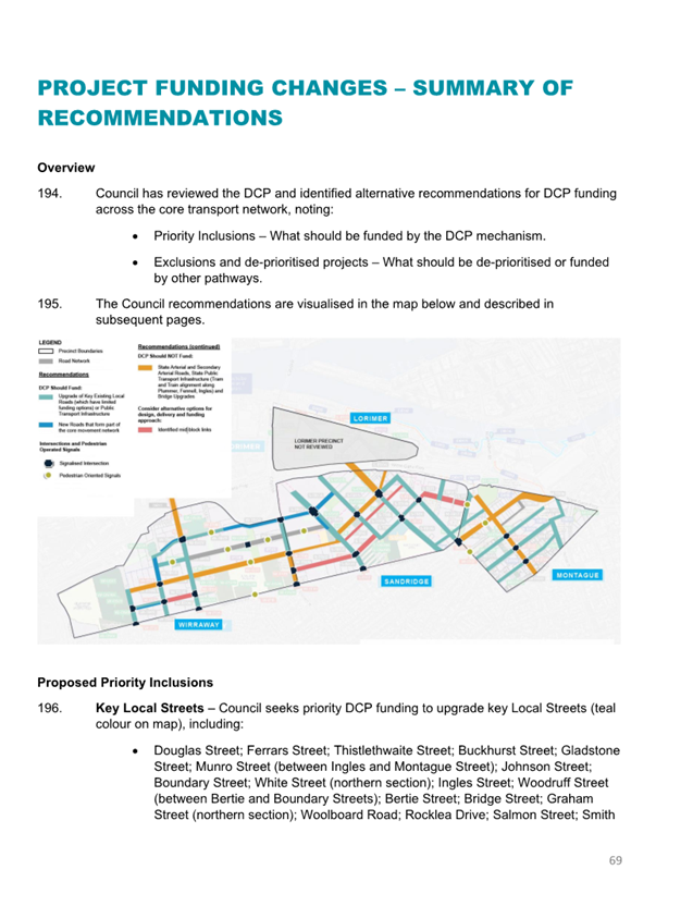
772 |
44.3% |
|
Option B |
739 |
42.4% |
|
Other / neither |
231 |
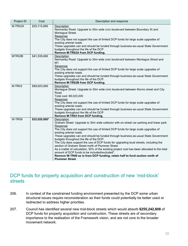
13.3% |
|
Total |
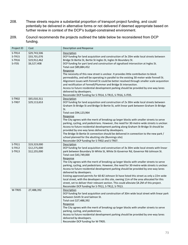
1,742 |
100% |
Note: the bulk email-submission (55 people) identified Neither Option or Option B on behalf of the represented parties. The submission also noted a preference for several changes for inclusion that are also included in Option B such as removal of the median, inclusion of 2x pedestrian crossings and increased parking bay widths. The submission has been in included as 'Other/Neither’ in the above table.
5.16 Survey participants living on Inkerman Street and the surrounding streets who provided feedback through HYS responded as follows:
|
HYS Survey |
||
|
Design Option |
Total No. |
Total % |
|
Option A |
442 |
42.2% |
|
Option B |
506 |
48.3% |
|
Other /neither |
100 |
9.5% |
|
Total |
1,048 |
100% |
5.17 The project area is contained wholly within St Kilda East, Balaclava and St Kilda. The majority of HYS survey respondents, 1,226 of the 1,579, were from these three suburbs equating to 77.6% of HYS respondents (or 70% of all respondents).
|
HYS and Pop-up
Surveys |
||
|
Design Option |
Total No. |
Total % |
|
Option A |
531 |
43% |
|
Option B |
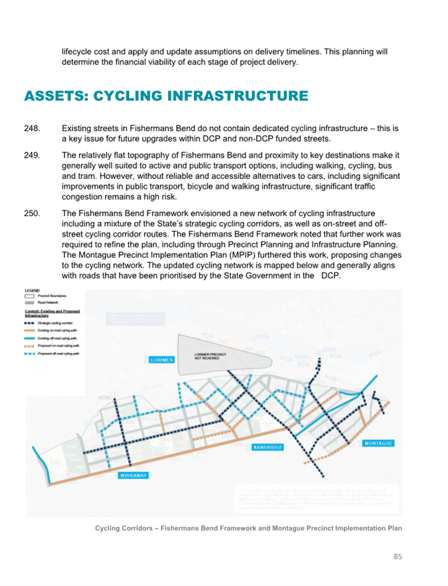
577 |
47% |
|
Other / neither |
118 |
10% |
|
Total |
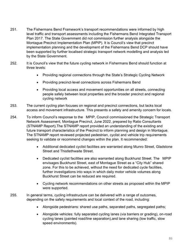
1,226 |
100% |
5.18 Businesses on Inkerman Street that provided feedback through HYS responded as follows:
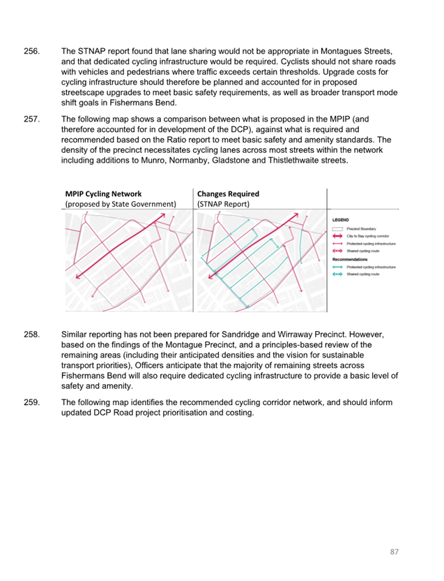
|
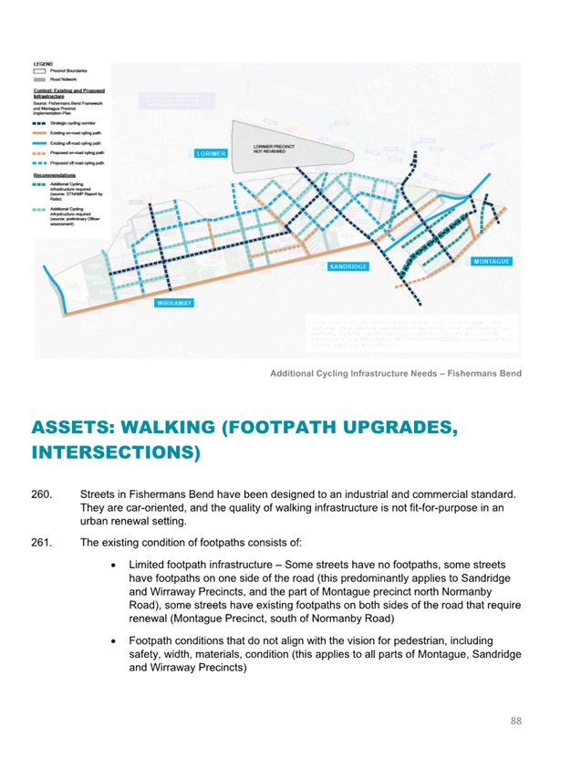
HYS Survey |
||
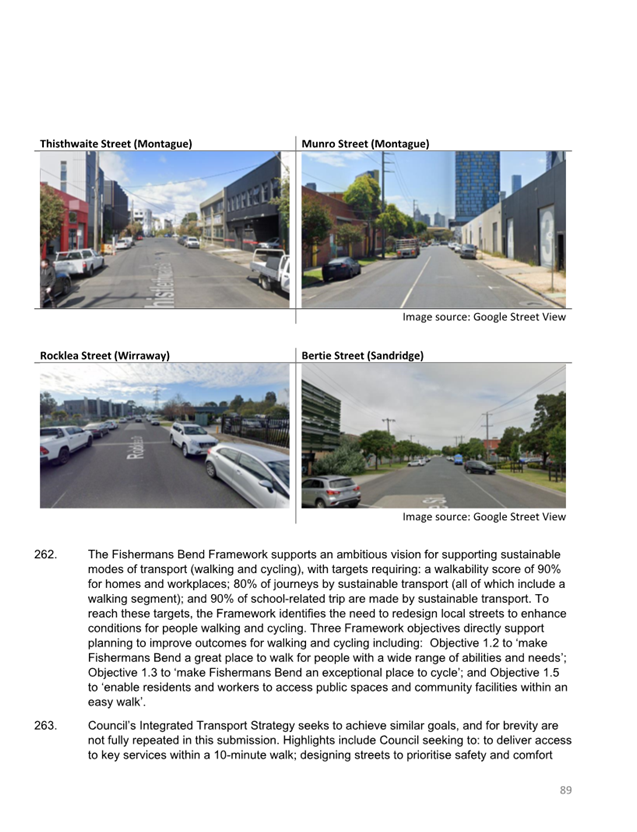
|
Design Option |
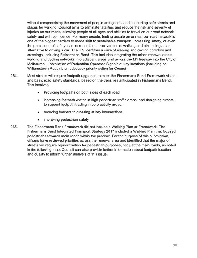
Total No. |
Total % |
|
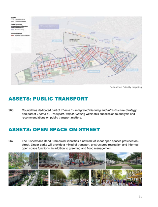
Option A |
9 |
21.4% |
|
Option B |
26 |
61.9% |
|
Other / neither |
7 |
16.7% |
|
Total |
42 |
100% |
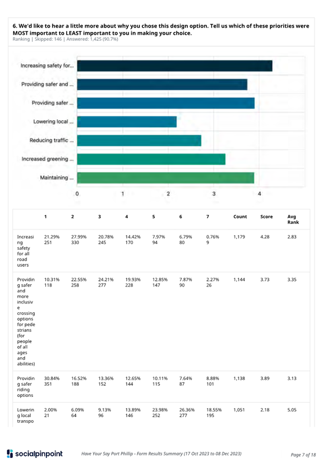
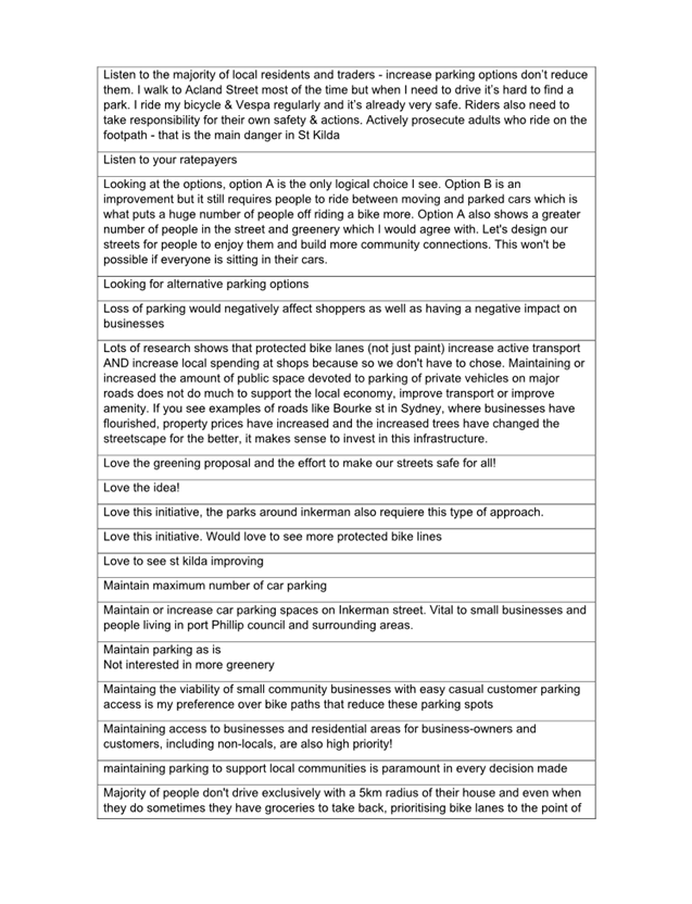
5.19 Prioritising project outcomes was an optional question in the HYS survey (90.7% of respondents completed this question). Irrespective of the design option selected, participants that responded to this question listed the following two options in their ‘top-three’ priorities:
· Providing increased safety for all road users
· Providing safer more inclusive crossings
5.20 Respondents who selected Option A as their preferred design option, on average, listed their highest priority as providing safer riding options. These respondents listed maintaining on-street parking as the lowest priority.
5.21 Respondents who selected Option B or neither option as their preferred design option, on average, listed their highest priority as maintaining on-street parking.
Option B respondents listed lowering local transport emissions as the lowest priority along with reducing traffic congestion by providing active transport options.
Respondents that selected neither design option, listed lowering local transport emissions as the lowest priority with along with providing safer riding options.
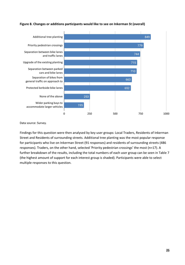
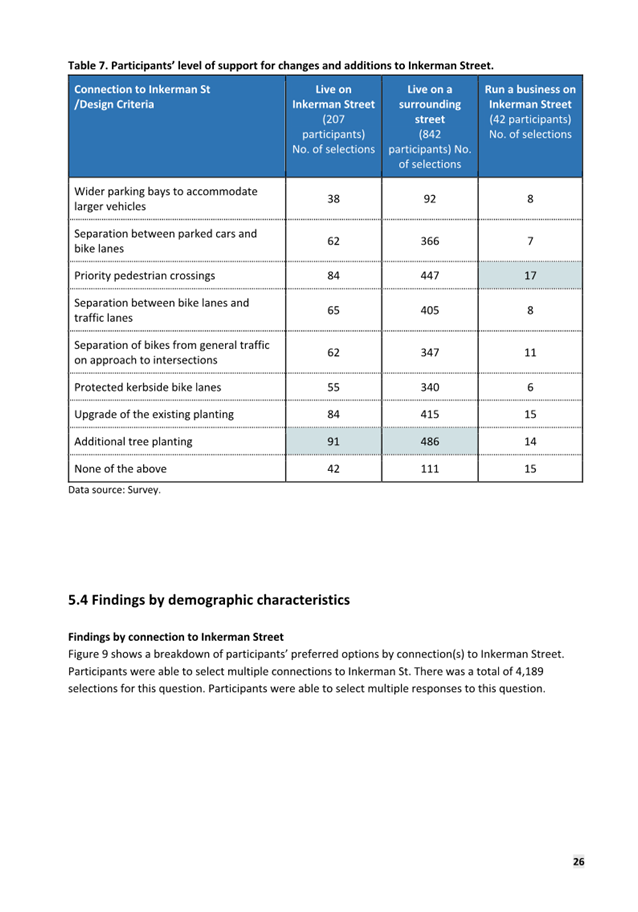
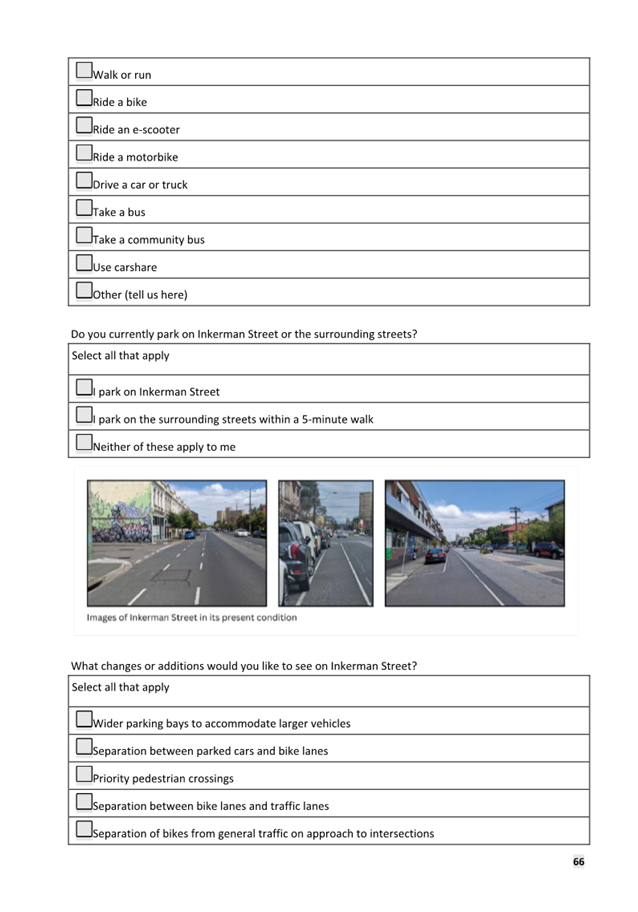
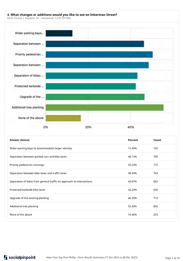
5.22 When asked ‘What changes or additions would you like to see on Inkerman Street?” participants were able to select multiple responses. The most selected options were as follows:
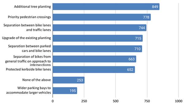
5.23 Participants who lived on Inkerman Street and participants who lived on or one of the surrounding streets selected ‘Additional tree planting’ as the change they would most like to see on Inkerman Street.
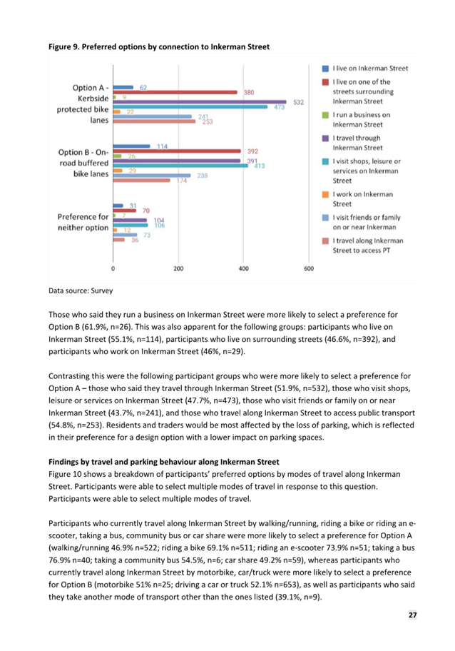
5.24 Survey responses from the following participant groups selected Option A as their preferred design option:
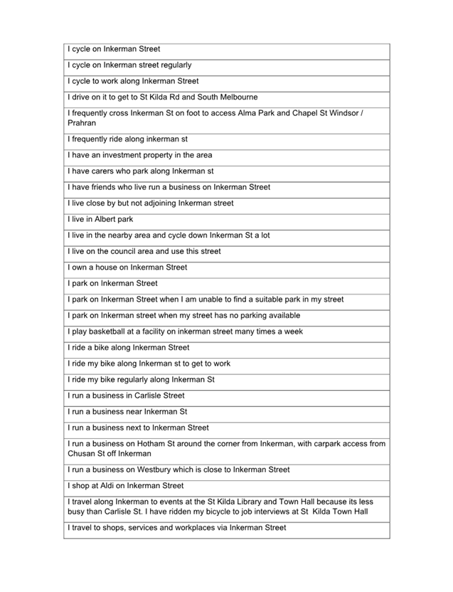
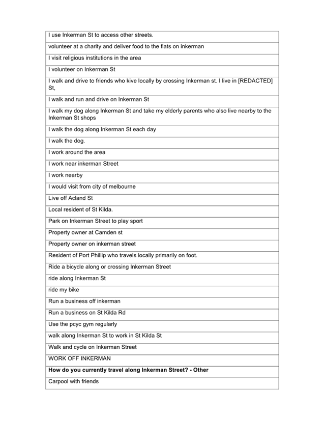
· Those who travel through Inkerman Street
· Those who visit shops, leisure or services on Inkerman Street
· Those who travel along Inkerman Street to access public transport.
5.25 Survey responses from the following participant groups selected Option B as their preferred design option:
· Those who lived on Inkerman Street
· Those who run a business on Inkerman Street
· Those who work on Inkerman Street.
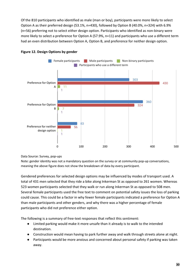
5.26 Younger survey participants (aged under 35) were more likely to select Option A. Older survey participants (aged over 50) were more likely to select Option B. Those between 35-49 were evenly split.
KEY THEMES / DESIGN CONSIDERATIONS
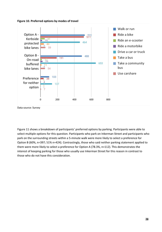
5.27 Some key themes and commentary have been identified from the 1,579 HYS survey responses, pop-up sessions and 61 project emails.
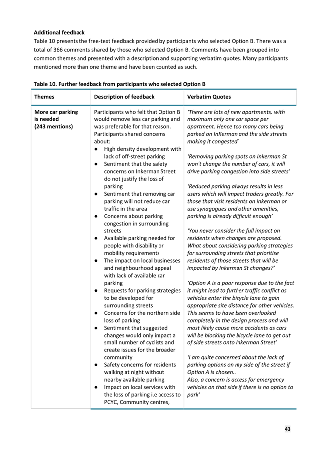
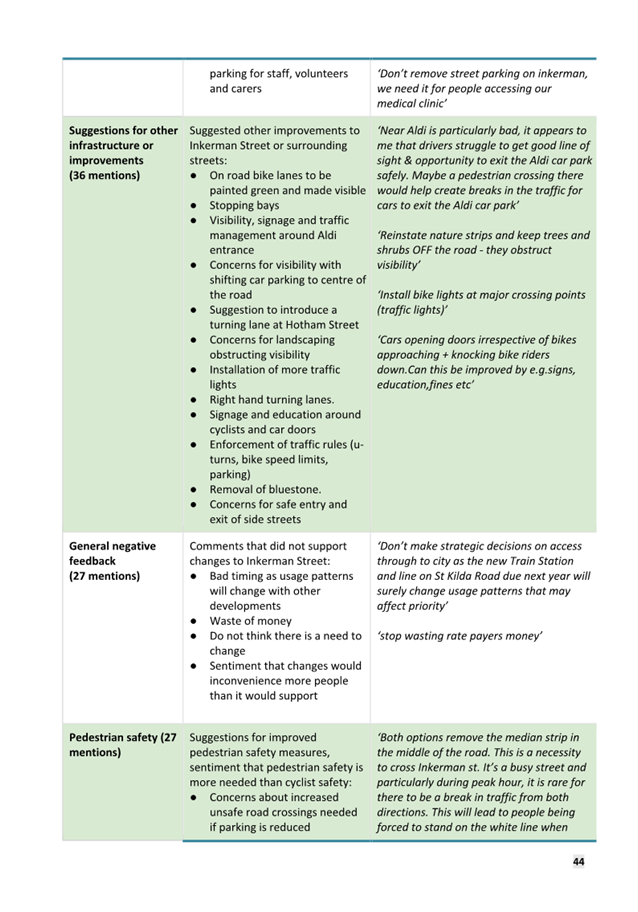
5.28 There was a total of 396 free text survey comments by respondents that selected Option A and 366 free text survey comments by those that selected Option B and 142 comments from those who selected neither option.
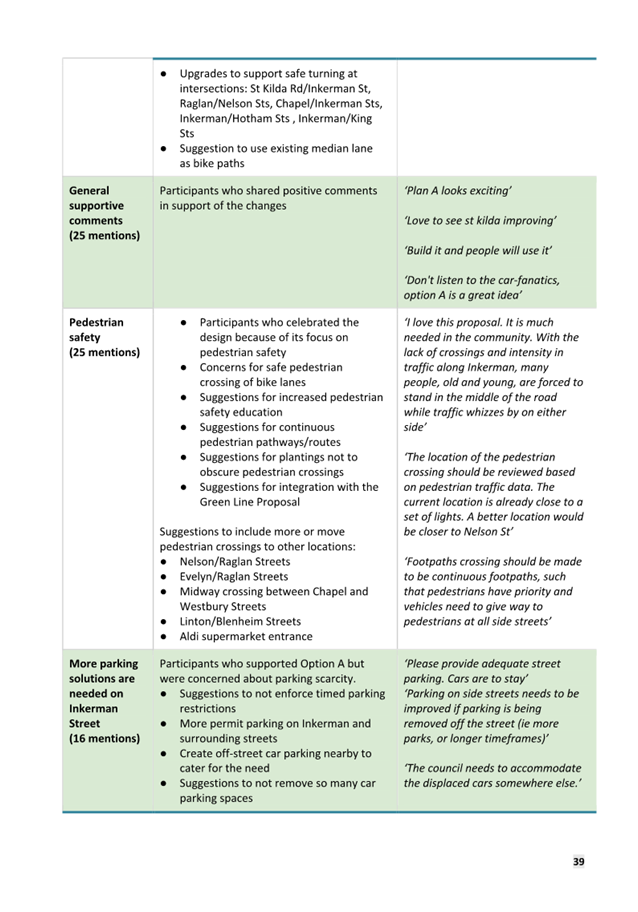
Key themes from the text survey comments relating to the proposed project and design options are listed below:
|
Option A Mentions |
Option B Mentions |
Other / neither |
|
|
1) Support for safety improvements including a protected bike lane |
772 |
n/a |
n/a |
|
2) Support for safety improvements including a buffered on-road bike lane |
n/a |
739 |
n/a |
|
3) Support for other or neither of the design options presented Note: the bulk email-submission identified Neither Option or Option B on behalf of the 55 represented parties - these included as 'other/neither’ in this table. |
n/a |
n/a |
231 |
|
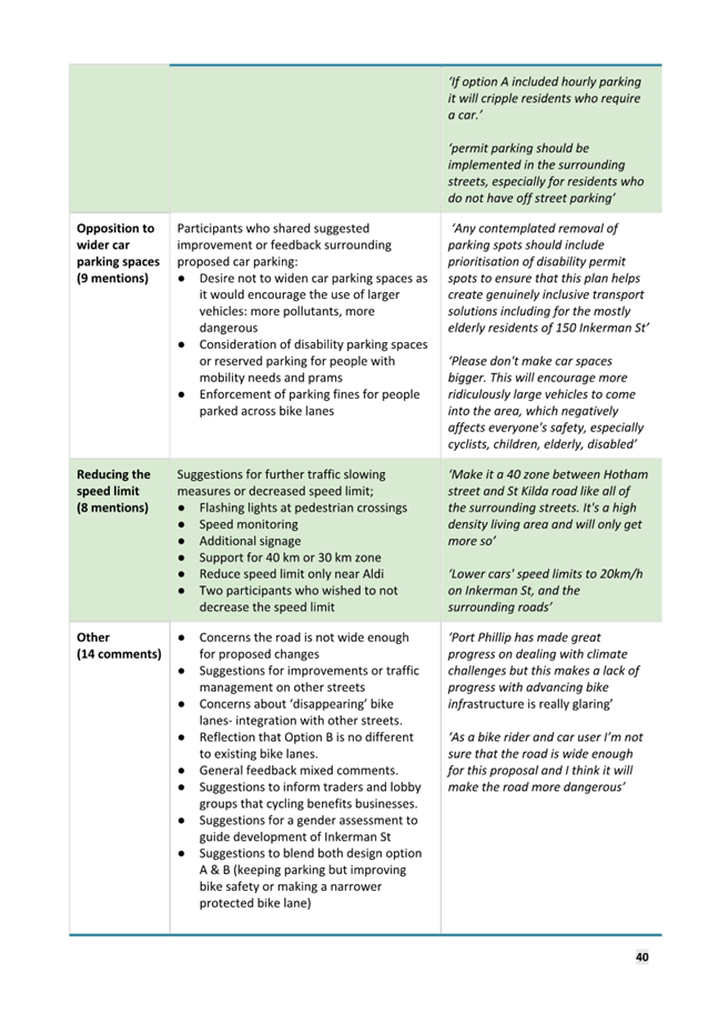
4) Concerns related to reduced parking / need for parking solutions Option A – need for parking
solutions / management |
16 |
243 |
83 |
|
5) Comments in support for increased rider safety Option A - support for a physically
separated bike lane |
141 |
8 |
n/a |
|
6) Support for enhancing greening and improved amenity |
94 |
18 |
n/a |
|
7) Comments that there is no need for change |
n/a |
n/a |
106 |
|
8) Comments in relation to pedestrian safety |
25 |
27 |
5 |
|
9) Support for other amenity enhancements |
29 |
36 |
n/a |
|
10) Comments in relation to reduced speed limit |
8 |
18 |
3 |
Note: Comments received at the pop-up
sessions generally aligned with the key themes received through HYS and emailed
correspondences.
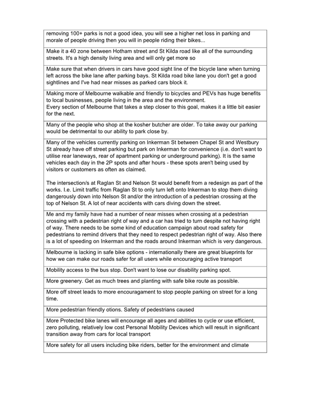
5.29 There are several other comments or design change suggestions raised through the engagement period.
|
Design change suggestions |
|
a) Relocation of the proposed zebra crossing proposed between Young Street and Blenheim Street to between Raglan Street and Nelson Road. |
|
b) Consider changing the pedestrian crossing near Aldi (adjacent to Marriott Street) to a pedestrian operated signal. |
|
c) Consider changes to existing parking restrictions: · Short-Term Parking Restrictions between Malakoff Street and Leslie Street · Changes to restrictions to support business needs · Changes to clear-way restrictions · Inclusion of dedicated DDA bays on both sides of Inkerman Street |
|
d) Suggestion to modify signal phasing at Chapel Street and Inkerman Street to provide a dedicated right turn phase for north bound vehicles. |
|
e) Suggestion to select low-maintenance plant species for any garden beds. |
|
Note: Other suggestions were received that relate to items that were included in the designs, were out of scope and / or have either have already been investigated or are not viable from a technical perspective. |
6. LEGAL AND RISK IMPLICATIONS
6.1 Council has an obligation to mitigate high-risk environments that impact the local community, particularly where the asset is owned and managed by Council, as is the case with Inkerman Street. Given the corridor’s crash history, addressing safety risks helps Council discharge its liability.
6.2 Council retains the necessary powers under legislation including the Road Management Act 2004 and Local Government Act 2021.
6.3 Council requires Department of Transport and Planning approval for works that are major traffic control items. The following safety treatments proposed in both project options are considered major traffic control items: speed limit reduction, modification to signals, installation of pedestrian zebra crossings with flashing lights and modifications to clearway signage. Whilst officers have received in principal support for the project, formal approval will be sought as part the next phase of the project.
6.4 The project will require Council to work with the utility companies where their assets need to be relocated. Permits from utility companies will be sought as part of the detailed design process.
7. FINANCIAL IMPACT
7.1 The Inkerman Safe Travel Corridor has funding allocated in the Council Budget.
7.2 Inkerman Street’s road-surface is in average/poor condition and requires re-sheeting (including line-marking). The re-sheeting works are part of Council’s Asset Renewal Program and budget. Combining required works can result in cost savings for Council.
7.3 Given the crash history, Council would seek funding through the Federal Blackspot Program and the Transport Accident Commission’s Safe Local Roads and Streets Program to reduce budgetary impact on Council.
8. ENVIRONMENTAL IMPACT
8.1 There is no environmental impact from the release of this report.
9. COMMUNITY IMPACT
9.1 The release of this report and attachments provides the community an opportunity to understand the differing community perspectives / sentiment related to the project.
10. ALIGNMENT TO COUNCIL PLAN AND COUNCIL POLICY
10.1 The Inkerman Safety Improvement Project aligns to Strategic Direction 2 of the adopted Council Plan 2021-31:
Liveable: Port Phillip is a great place to live, where our community has access to high quality public spaces, development and growth are well managed, and it is safer and easy to connect and travel within.
11. IMPLEMENTATION STRATEGY
11.1 TIMELINE
11.1.1 A report will be tabled at a future meeting with a recommendation on how to proceed with the project. Any recommended changes to the design, in response to the community feedback, will form part of that report.
11.2 COMMUNICATION
11.2.1 The Engagement Summary will be uploaded onto the project page following the Council meeting.
11.2.2 Following the Council meeting, community members who requested to be kept informed about the project either through Have Your Say or through the project page will be emailed a project update and the timing of the future Council meeting once a date has been set.
12. OFFICER MATERIAL OR GENERAL INTEREST
12.1 No officers involved in the preparation of this report have any material or general interest in the matter.
|
ATTACHMENTS |
1. Inkerman Street Engagement Summary Report 2. Inkerman St HYS Survey Response Overview |
Meeting of the Port Phillip City Council
20 March 2024
|
10.2 |
Draft Dog Off-Leash Guideline for Public Consultation |
|
Executive Member: |
Tarnya McKenzie, Interim General Manager, Community Wellbeing and Inclusion |
|
PREPARED BY: |
Claire Ulcoq, Open Space Planner Dana Pritchard, Manager Open Space Recreation and Community Resilience |
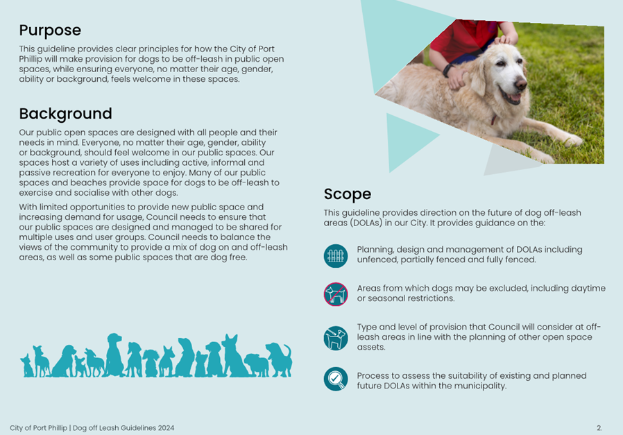
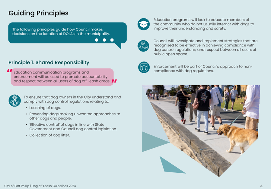
1. PURPOSE
1.1 To consider release of the draft Dog Off-Leash Guideline for community consultation.
2. EXECUTIVE Summary
2.1 Council is developing a Dog Off-Leash Guideline (the draft Guideline) to create a framework for dog off-leash areas (DOLAs) within the municipality.
2.2 The draft Guideline is being developed in response to increasing community requests (for and against) and in response to a resulting action in the Places for People: Public Space Strategy 2022 – 2032 (PSS) and the Domestic Animal Management Plan 2022 – 25 (DAMP).
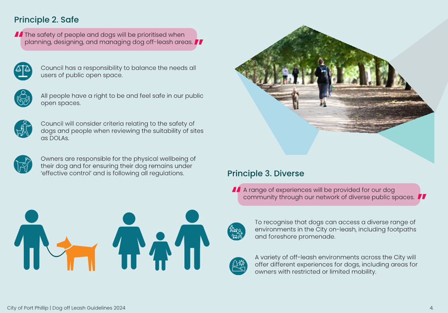
2.3 The draft Guideline provides clear principles for how Council will make provision for dogs to be off-leash in public open spaces, while ensuring that everyone feels welcome in these spaces.
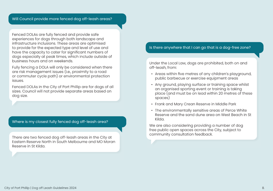
2.4 The draft Guideline recommends that:
· Current restrictions remain in place (including distance from playgrounds and sports grounds in use)
· Dogs now also be prohibited at all times, both on or off-leash, from entering specialised sports fields (those sporting reserves that include synthetic pitches or premier level grass playing surfaces)
· Council considers providing a number of dog free public open spaces across the City.
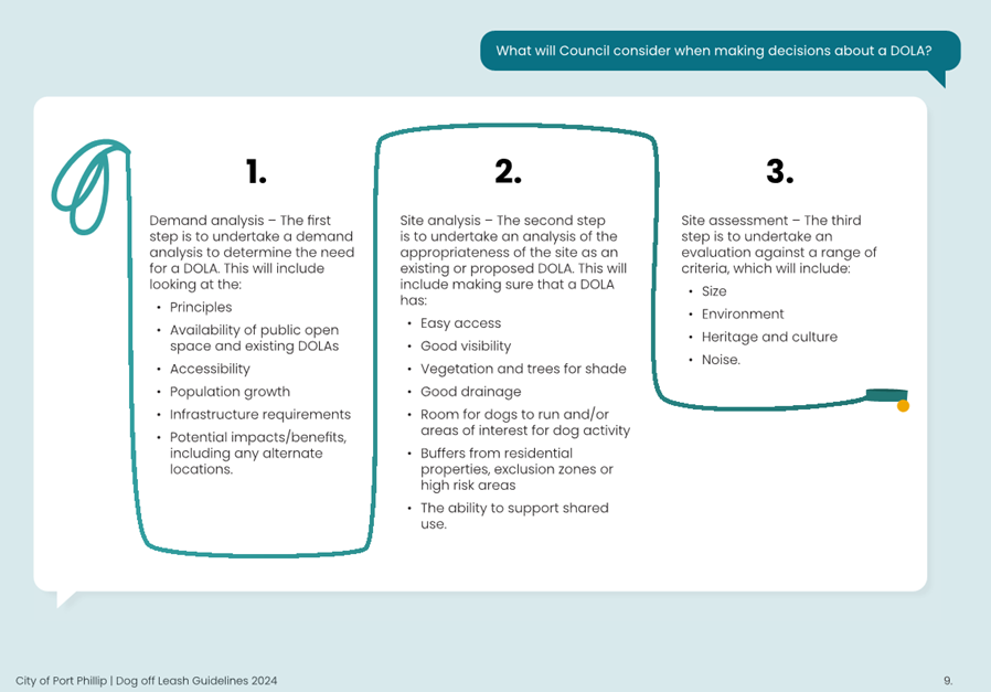
2.5 The draft Guideline outlines what Council will consider when making a decision about a DOLA, including a demand analysis, site analysis and site assessment.
2.6 Extensive engagement has been undertaken through the development of the draft Guideline, including a deliberative panel who developed the five (5) key principles which underpin the draft Guideline.
2.7 The draft Guideline is being presented to Council prior to Stage 3 of the community engagement commencing on Monday 25 March 2024 and ending on Sunday 28 April 2024.
|
3. RECOMMENDATION That Council: 3.1 Releases the draft Dog Off-Leash Guideline for community consultation. 3.2 Authorises the CEO, or their delegate, to make amendments to the draft Dog Off-Leash Guideline to reflect any changes through this resolution and to make minor editorial adjustments to prepare the document for consultation. |
4. KEY POINTS/ISSUES
Context
4.1 There is limited public space within the municipality and increasing dog ownership, and visitation, with over 8,000 dogs registered in the City of Port Phillip. This is creating increasing tensions between dog and non-dog spaces.
4.2 There are regular requests to Council regarding dogs, including requests for both more and less DOLAs, requests for more fenced dog off-leash areas, concerns about dog owner control/compliance and impacts of dogs on sports grounds and residential amenity.
4.3 Many of these requests/concerns were raised through the development of Council’s PSS and DAMP.
4.4 In response, an action was included in the PSS to ‘investigate opportunities for new dog off-leash areas and review permitted times in all existing public open spaces including beaches’ and in the DAMP to ‘develop criteria for dog off-leash parks and investigate opportunities for new dog off-leash areas using these’.
4.5 Council are therefore developing the draft Guideline which will:
· Outline Council’s position on the provision, distribution, design and management of DOLAs across the municipality
· Inform options for our current DOLAs and any required changes, such as changes to time restrictions
· Inform new locations and the suitability of existing locations for DOLAs
· Guide the future of all our dog off-leash restrictions across public open space, including parks, beaches and sports fields
· Provide Council officers with an evidence-based process for assessing community requests and petitions in relation to DOLAs.
4.6 To inform the draft Guideline, a three-phase community engagement process has been adopted, which included a deliberative community panel to help shape the development of the key principles which underpin the draft Guideline. This is further discussed in section 5 of this report.
Existing dog off-leash areas
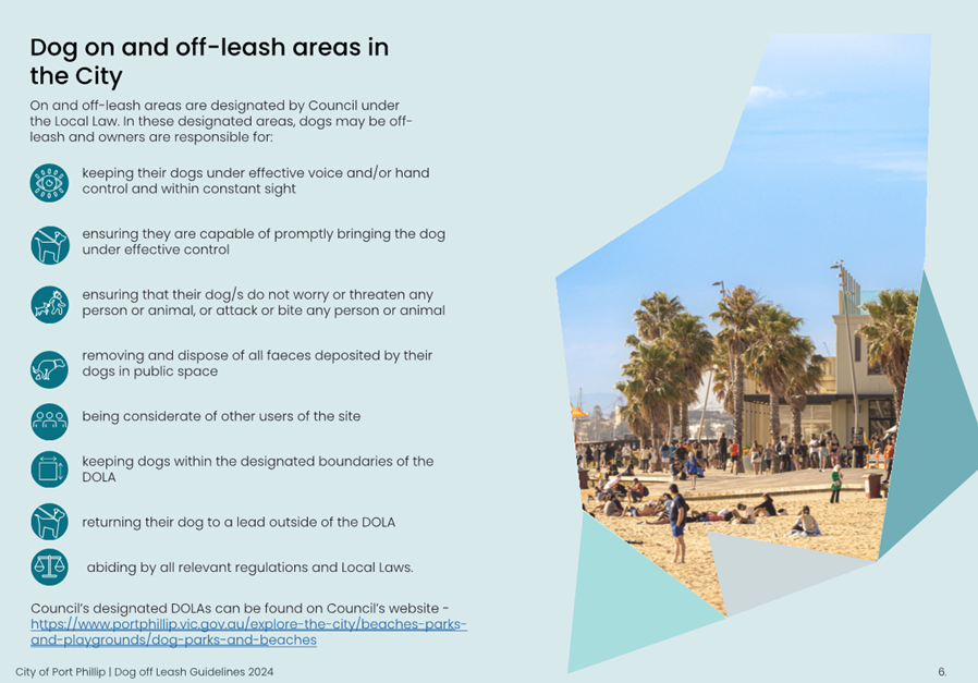
4.7 Many of our public open spaces and beaches across the City of Port Phillip provide space for dogs to be off leash. This includes:
· 15 different beach zones with varying dog off-leash conditions
· 16 public open spaces across the municipality that are designated for dog off-leash areas (including two in Albert Park Reserve, managed by Parks Victoria)
· 2 fenced dog off-leash areas including Eastern Reserve North in South Melbourne and MO Moran Reserve in St Kilda
· There are also several off-leash areas bordering the municipality including the Kings Way fenced dog park, Fawkner Park and Elsternwick Park.
4.8 A full list and maps of our DOLAs is on our website.
What we heard during phase 1 and 2 community engagement
4.9 During phase 1 and 2 of community engagement we heard that:
· There is a diversity of views across our community about where dogs should be permitted to be on and off-leash
· The varied timed restrictions across our beaches during the warmer months is confusing, and that people want more off-leash beaches and also beaches where dogs are prohibited
· Both dog and non-dog owners are both supportive and not supportive of fenced DOLAs
· People would like separate areas for small and large dogs
· The community would like dog agility equipment and dog waste bags to be provided
· The guidelines will not work unless there is greater enforcement across the municipality.
· Our communication in our public open spaces and on our website about the rules and responsibilities is not clear
· DOLAs work well when:
o They are large open areas
o There is access to water, shade and sensory experiences for dogs
o There are opportunities for dogs and owners to socialise
o Owners are responsible for their dog’s behaviour
o Separation is provided between different user groups
· DOLAs do not work well when:
o There is a lack of bins, water or shade
o There is not separation between user groups
o Small and large dogs are together in a confined area
o Dog owners do not have effective control over their dogs
o Dog owners not picking up dog poo or not using bags.
How we are responding to what we heard
4.10 In response to what we heard during phase 1 and 2 of the community engagement process, we have developed the draft Guideline. The key recommendations of the draft Guideline to note include:
Changes to restrictions for sports fields
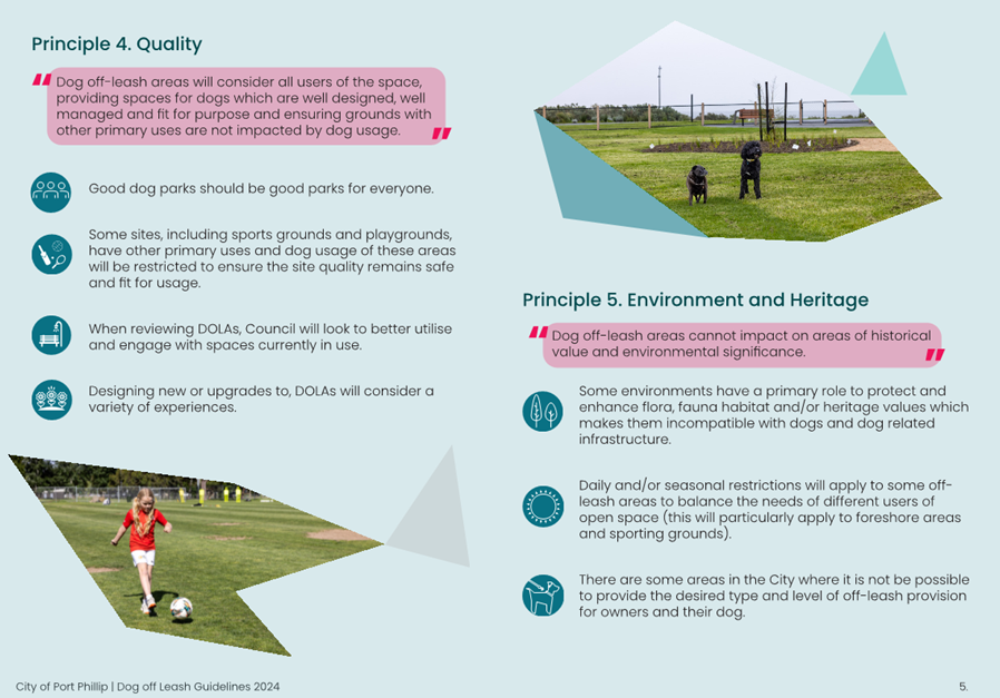
· Sports fields are ideal spaces to be used as DOLAs due to their size, however the primary use of these spaces is for organised sport. This means that priority is provided for sport, and they need to be maintained to ensure they are fit for purpose, in line with sporting association requirements.
· The draft Guideline recommend that dogs are prohibited from entering our specialised sports fields (those sports fields that include synthetic pitches or premier level grass playing surfaces) at all times.
· Subject to community consultation, Council is proposing for dogs to be prohibited from North Port Oval in Port Melbourne, SS Anderson (Pitch 1) and, once complete, the Community Synthetic Ground (Pitch 3) in JL Murphy Reserve in Port Melbourne.
· Other sports grounds that are currently DOLAs will continue to remain accessible outside sports usage, which is in line with the Local Law (only to those times when training or competition sport is not being played).
Dog free spaces
· During phase 1 and 2 of the community engagement process we heard from some of our community that they would like access to a dog-free public open space.
· Under the Local Law, dogs are not currently permitted in some areas, including Perce White Reserve in Port Melbourne, part of West Beach in St Kilda, and Frank and Mary Crean Reserve in Middle Park.
· Subject to community consultation, Council will look to designate more public open spaces across our network as dog-free. This would mean that dogs would not be permitted in some areas, both on and off-leash.
· Council will test these ideas with the community during consultation, having consideration of:
o The size of the public open space
o Proximity to other public open spaces and DOLAs
o The existing restrictions under the Local Law (e.g. dogs are not permitted within 5 metres of a playground, public barbecue or exercise equipment which means some of our small public open spaces may not be suitable for dogs).
Changes to beach restrictions
· Further work is required to determine whether the timed restrictions across our beaches can be made consistent and whether there is an option for one beach where dogs are prohibited all year round.
· The initial challenges of this work include beach cleaning and allowing dog owners to walk their dogs between beaches if there was a dog free beach.
Assessment process and criteria
· The draft Guideline includes a process for Council to follow when making decisions about a DOLA, including:
o Demand analysis to determine the need for a DOLA, which will include looking at the principles, availability of open space and existing DOLAs, accessibility, population growth, infrastructure requirements and potential impacts/benefits.
o Site analysis to determine the appropriateness of a site, including making sure that a DOLA has easy access, good visibility, vegetation and shade, good drainage, room for dogs to run, appropriate buffers to surrounding uses and residences and the ability to support shared uses.
o Site assessment against criteria to mitigate any impacts associated with size, environment, heritage and culture and noise.
Fenced dog spaces
· Further work will be undertaken prior to adoption on assessments of current fenced areas and potential new fenced dog parks. This will be considered during adoption of the DOLG
5. CONSULTATION AND STAKEHOLDERS
Community engagement process
5.1 The community engagement approach for the development of the draft Guideline has been undertaken in three phases:
5.1.1 Phase 1 (November 2022 – February 2023):
· The purpose of this phase of engagement was to test our understanding of the key issues of shared open spaces around the municipality.
· This phase of community engagement included interviews/focused conversations, pop-ups, intercept surveys, workshops, online survey, and other online engagement activities. Over 2,600 responses were received during phase 1.
· A full and summary report are available on Council’s Have Your Say page.
5.1.2 Phase 2 (May – October 2023):
· The purpose of this phase of engagement was to develop the key principles underpinning the draft Policy and Guideline with a community deliberative panel made up of 33 community members.
· The community deliberative panel met four times over June and July 2023 to discuss and share ideas based on a wide selection of information, including research, results of broader engagement program, as well as presentations from Council officers and a subject matter expert.
· The deliberative engagement panel developed the key principles which underpin the draft Guideline.
5.1.3 Phase 3 (March – April 2024):
· The purpose of this phase of engagement is to seek feedback from the community on the draft Guideline.
· This phase will include:
o A survey on Have Your Say
o The opportunity for direct submissions via email
o Social media updates
o A face-to-face session with the community deliberative panel.
6. LEGAL AND RISK IMPLICATIONS
6.1 There are no identified legal implications associated with the draft Guideline as the Order No. 4 of Port Phillip City Council enforces the legal requirements of effective dog control and owner obligations in designated areas.
6.2 The Guideline will help reduce risks associated with conflicting users in public open spaces, soil contamination and environmentally sensitive areas, heritage protection and amenity impacts including noise.
6.3 Any changes to DOLAs resulting from the adopted Guideline may require changes to the local law and will follow the formal process.
7. FINANCIAL IMPACT
7.1 The Guideline aims to ensure that Council’s expenditure in DOLAs is financially sustainable, in consideration of the cost-benefits associated with investing in these areas.
7.2 Implementing the Guideline should reduce the staff resources required to respond to community requests and petitions for DOLAs.
7.3 The intent of the Guideline is to ensure Council assesses the cost-benefits associated with investing in environments used by owners and their dogs.
8. ENVIRONMENTAL IMPACT
8.1 The Guideline will ensure that areas of environmental significance are not impacted by DOLAs.
8.2 It is intended that the Guideline will provide clear buffers and Guideline on the exclusion of and/or management of environmentally sensitive areas in DOLAs.
9. COMMUNITY IMPACT
9.1 The Guideline will provide Council with a clear and concise position on dogs exercising off-leash, including how we provide for and manage DOLAs.
9.2 This project has been informed by an extensive three phase community engagement process, including a community deliberative panel consisting of 33 community members, to ensure that the diversity of opinions in our municipality were heard.
10. ALIGNMENT TO COUNCIL PLAN AND COUNCIL POLICY
10.1 The development of the draft Guideline aligns with the Liveable Port Phillip Strategic Direction in the Council Plan 2021 – 31. The PSS is a core strategy under this Strategic Direction, and the development of the draft Guideline is a short-term priority action under the PSS.
11. IMPLEMENTATION STRATEGY
11.1 TIMELINE
· In the event that Council resolves to release the draft Guideline for community consultation, the following will occur:
|
20 March 2024 |
Draft Guideline presented to Council to consider release for community consultation |
|
25 March 2024 – 28 April 2024 |
Community consultation on the draft Guideline |
|
May – June 2024 |
Consideration of submissions on the draft Guideline |
|
3 July 2024 |
Updated Guideline presented at the Ordinary Meeting of Council for adoption |
|
July 2024 onwards |
Commence implementation of the Guideline |
11.2 COMMUNICATION
· Release of the draft Guideline will be promoted on Council’s website, Have Your Say page and through social media.
11.3 NEXT STEPS
· Implementation of the Guideline will occur in 20242/5 financial year and will include any changes to the designation of areas under the Local Law, improvements to signage and any other actions identified through engagement and adoption process.
12. OFFICER MATERIAL OR GENERAL INTEREST
12.1 No officers involved in the preparation of this report have any material or general interest in the matter.
|
ATTACHMENTS |
1. Draft Dog Off Leash Guidelines |
Meeting of the Port Phillip City Council
20 March 2024
|
Council Submission to the Victorian Government's Montague Precinct Implementation Plan (Fishermans Bend) |
|
|
Executive Member: |
Brian Tee, General Manager, City Growth and Development |
|
PREPARED BY: |
Gareth Nevin, Senior Program Manager Fishermans Bend Phoebe Hanna, Senior Heritage Planner |
1. PURPOSE
1.1 This report provides an overview of the Victorian Government’s draft Montague Precinct Implementation Plan (MPIP), which has been released for public consultation. It seeks endorsement of a submission that sets out the City of Port Phillips response to the Draft MPIP, and the further work required for its completion.
2. EXECUTIVE Summary
2.1 The Victorian Government’s Fishermans Bend Framework is the overarching planning strategy that will guide the urban renewal of Fishermans Bend. The strategy was released in 2018 and noted that further work was required for its implementation, including precinct planning and infrastructure planning.
2.2 On 1 December 2023, the Victorian Government released the draft Montague Precinct Implementation Plan (MPIP) for public consultation. A copy of the draft MPIP can be found on the Engage Victoria Website linked below. The Draft MPIP is intended to refine and implement the Fishermans Bend Framework vision at the local level.
https://engage.vic.gov.au/montague-precinct-implementation-plan
2.3 Officers have prepared a submission in response to the draft MPIP. The submission can be found in Attachments 1 and 2 (being submission Parts A and B) and is being presented for Council endorsement. Part A contains the submission summary, and can be read alone, while Part B contains detailed discussion points which explain and reinforce recommendations, and provide further information for consideration by the Victorian Government.
2.4 The submission acknowledges and welcomes the Victorian Government’s engagement with Council in the development of the MPIP, and recognises several matters of support. The Draft MPIP presents an inspiring and graphically impressive view of what Montague could look like in the future, and a creative approach for its implementation. The Draft MPIP’s overall vision for the area is generally supported subject to further development of identified issues and recommendations listed in the submission.
2.5 The focus of the submission is on key issues and recommendations that seek to improve the plan’s scope, clarity, rigour, and implementation. The plan requires further work to resolve key issues including document aim and structure; infrastructure funding and delivery; direction of the street and laneway network; flooding and water management; planning controls; and public transport integration. The issues have been addressed thematically, providing an actionable level of detail to provide direction for the document’s improvement.
|
That Council: 3.1 Welcomes the Victorian Government’s development of and consultation on the Draft Montague Precinct Implementation Plan. 3.2 Endorses the attached submission to the Victorian Government’s Draft Montague Precinct Implementation Plan (Attachments 1 and 2). 3.3 Authorises the CEO, or their delegate, to write to the Victorian Government, notifying them of the Council Submission and seeking: 3.3.1 Confirmation of Council involvement in any updates to the Montague Precinct Implementation Plan, planning scheme amendment and associated supporting material. 3.3.2 Receipt and review of the planning controls that will form part of a planning scheme amendment that implements the Montague Precinct Implementation Plan. 3.3.3 Receipt and review of the Making Montague supporting material prior to finalisation of the Montague Precinct Implementation Plan for the upcoming planning scheme amendment. 3.3.4 Involvement in aligning the government’s infrastructure funding strategy (including development contributions plan) and Montague Precinct Implementation Plan processes and outcomes, noting that Council has made a separate submission to the Planning Scheme Amendment GC224 Fishermans Bend Development Contributions Plan process. 3.4 Authorises the CEO, or their delegate, to make minor amendments to the submission that do not materially alter the intent of the submission. |
4. KEY information
Background - Fishermans Bend Framework - Implementation
4.1 The Fishermans Bend Framework (the Framework) is the overarching long term strategic plan for development of Fishermans Bend towards 2050. The Framework designates five linked precincts – Montague, Lorimer, Sandridge, Wirraway and the Employment Precinct.
Figure 1 identifies the Fishermans Bend precincts, with Montague being at the eastern end abutting South Bank and South Melbourne.
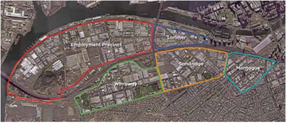
Figure 1 – Fishermans Bend Precincts (extract from the Framework)
4.2 The Framework was endorsed by the Victorian Government in 2018 with an understanding that further work was required to complete the details of the plan. The Framework includes an action plan that requires amongst other things:
· The preparation of precinct plans for each precinct, to ensure that each area is provided with the right level of fine grain detail for its implementation.
· The preparation of an infrastructure funding and financing approach for Fisherman’s Bend. This is being developed through a process that is separate but in conjunction with the precinct plans.
4.3 On 1 December 2023, the Victorian Government released milestone projects, which are separate, but can be read in conjunction:
· Informal Public Consultation on the Montague Precinct Implementation Plan [MPIP] – the focus of this Council Report.
· Formal Public Consultation for proposed Planning Scheme Amendment GC224 (Fishermans Bend Development Contributions Plan and Open Space Uplift Mechanism) – referred to in this report collectively as the ‘DCP’.
Background - Fishermans Bend Framework – Montague Precinct Vision and Context
4.4 The Framework sets a high-level vision for Montague Precinct that is “A diverse and well-connected mixed-use precinct celebrating its significant cultural and built heritage and network of gritty streets and laneways”.
4.5 Key elements of the Framework plan include:
· The 109 tram line creates two distinct neighbourhoods, Montague North and Montague South.
· New development in Montague will be centred on the transformation of Normanby Road into an active street that is attractively landscaped, pedestrian friendly and provides a key cycling connection through the precinct.
· New parks will provide opportunities for active recreation, including the enhancement of the existing bike path along the tram line into a green linear parkway.
· All streets will be fronted by well-designed buildings with shops and businesses at ground level and a high-quality pedestrian environment.
· The Southern part of Montague is distinguished by its laneways and heritage buildings, which are highly valued by the local community. To maintain these qualities, the adaptive re-use of heritage buildings is strongly encouraged.
· Buckhurst street will be established as a diverse and family-friendly community.
· Co-working spaces, small creative businesses and studios will contribute to the cultural identity of the area.
· Lower scale buildings along City Road and Boundary Street ensure that the precinct is well-integrated with its neighbours.
· The Ferrars Street Education and Community Precinct will support a range of community activities.
· A secondary community hub is co-located at the Montague Continuing Education Centre.
Figure 2 identifies the Framework’s infrastructure plan for Montague, which includes new open spaces, road and laneway connections.
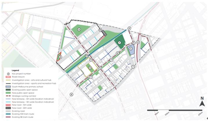
Figure 2: Infrastructure plan for Montague in the Fishermans Bend Framework 2018
4.6 Current development and permit activity in Fishermans Bend has created a notable clustering of development activity in Montague, creating urgency for precinct planning and delivery of infrastructure.
Public Consultation – Draft Montague Precinct Implementation Plan
4.7 The Fishermans’ Bend Taskforce released the Draft MPIP for consultation on 1 December 2023. A copy of the draft MPIP can be found on the Engage Victoria Website linked below.
https://engage.vic.gov.au/montague-precinct-implementation-plan
4.8 The MPIP expands the Fishermans Bend Framework vision, aiming to provide stakeholders with the necessary details to understand how Montague will adapt, transition and change over the next 10 years, setting a path toward the 2050 vision.
4.9 The MPIP is structured around 5 key moves:
· Key move 1 - Place Creation and Activation
· Key move 2 – Destination Laneways and Character
· Key move 3 – Local Parks and Streets
· Key move 4 – Activity Centres and Spines
· Key move 5 – Citywide connections and gateways.
4.10 Each Key Move is supported by catalyst initiatives and underpinned by actions to generate positive and sustainable momentum in the precinct. The MPIP contains an implementation plan that collates the various actions within each key move under the themes of planning scheme changes, future work and infrastructure delivery.
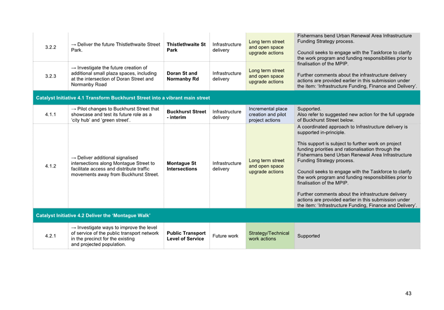
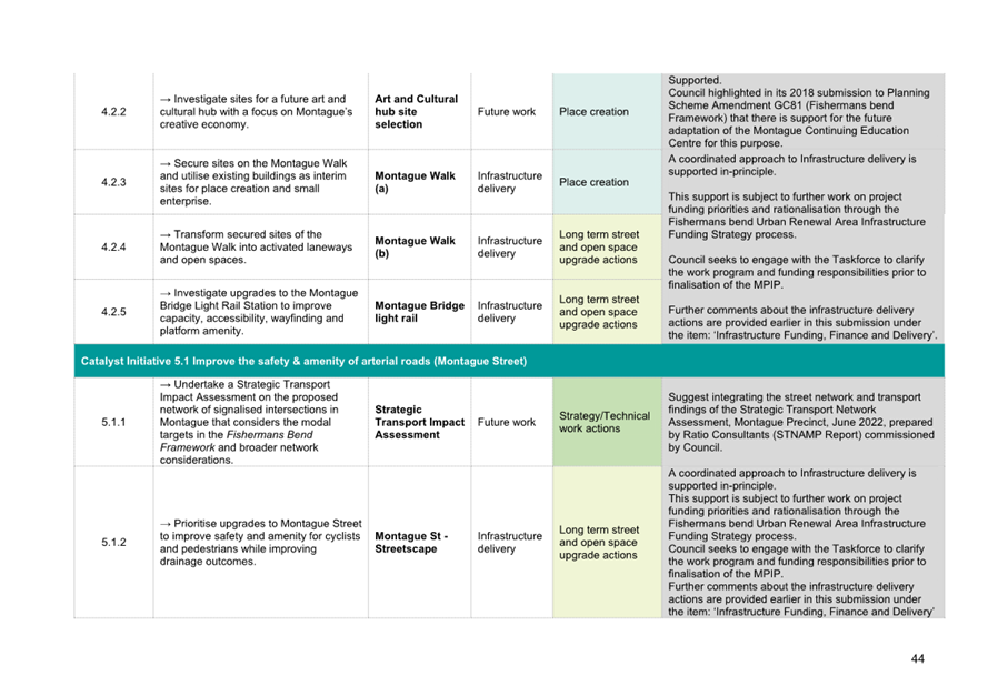
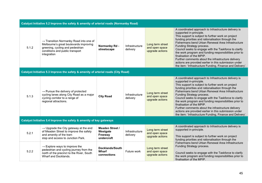
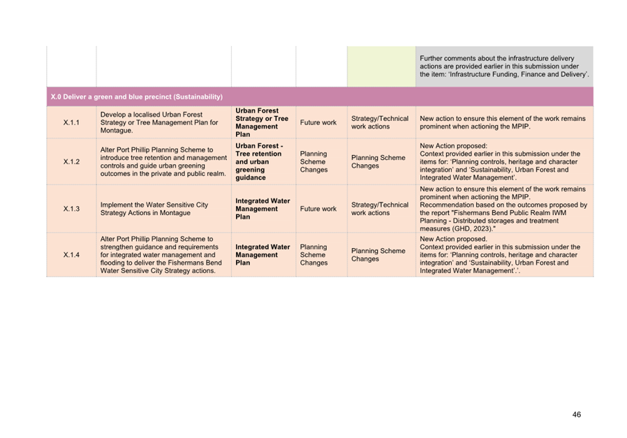
4.11 The MPIP will ultimately guide the assessment of all planning permit applications and frame future development, infrastructure, land use and investment. The Precinct Implementation Plan needs to provide sufficient detail and direction to enable separate implementation actions by the different stakeholders (Council, State departments and developers) that combined, will deliver on the vision. The MPIP will be reviewed every five years.
Council submission development
4.12 Council officers have prepared a submission in response to the MPIP’s public consultation process. The submission is being presented to Council for endorsement (Attachments 1 and 2).
4.13 The purpose of the new submission will be to:
· Welcome the Victorian Government’s engagement with Council in the development of the MPIP.
· Note that Council is broadly supportive of the MPIP, subject to further development of identified issues and recommendations listed in the Council’s submission.
· Set out the list of critical issues and specific recommendations requiring further work for the Victorian Government.
Council submission – What do we like about the plan?
4.14 Overall, the MPIP presents an inspiring and graphically impressive view of what Montague could look like in the future. The document:
· Is engaging and introduces creative ideas.
· Recognises and builds on the unique character and location of the Montague Precinct.
· Takes a visionary approach and sets a high bar for the future of the precinct.
· Articulates the challenges and opportunities around achieving the vision.
· Has strong community focused outcomes.
· Focuses on place creation, which has the potential to deliver creative outcomes in partnership.
· Envisions redeveloped wide streets and by creating linear people-centred parks, has the potential to develop a strong urban statement.
· Develops an activity centre, which is critical in making Montague a place of its own, noting the Montague Walk is a good response to the challenges of the precinct.
· Connects the precinct to its surrounds, capitalises on the precinct’s enviable location and improves some of the current significant barriers to movement.
· Sets the vision for an urban forest in the streets, open spaces and private realm initiatives and addresses the effects of increased urban heat by increasing tree canopies and combining them with a biodiverse range of understorey plant species.
Council submission – Outstanding issues and further work
4.15 Council’s support of the MPIP is subject to the list of issues and recommendations in this submission being addressed.
4.16 The following broad issues are of highest concern, as noted in the submission:
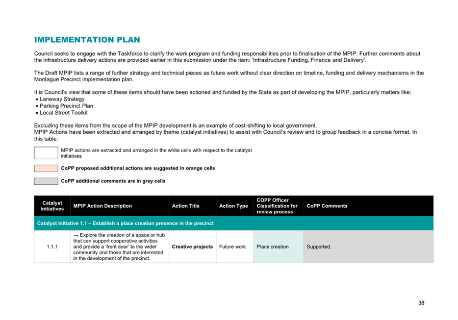
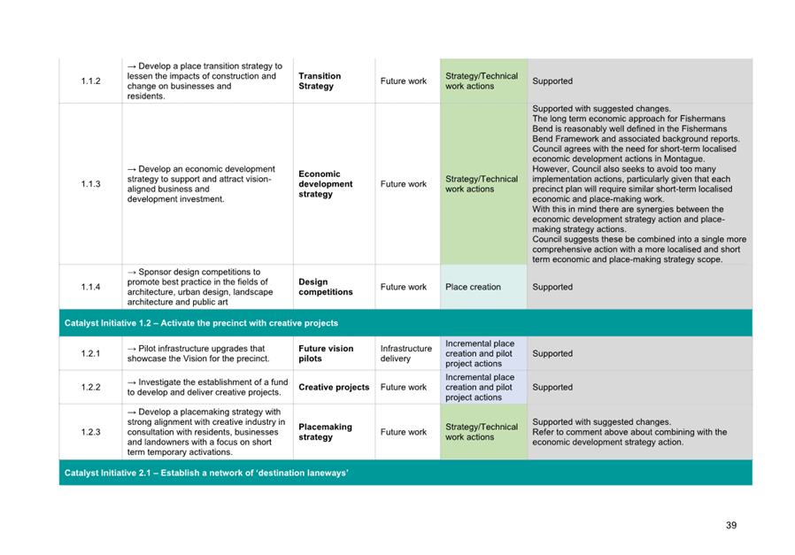
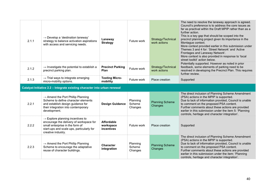
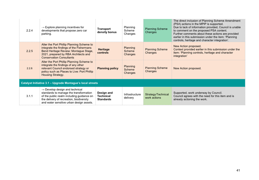
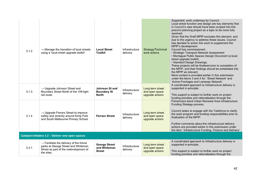
· Document aim and structure – Given the aspirational nature of the MPIP, the greatest concern is the lack of detail, clarity and rigor. As structured, the MPIP takes the form of a Design Document rather than a Precinct Implementation Plan with clear frameworks and resolved actions. For developers, planners and other stakeholders the failure to separate the ‘aspirational’ content from the confirmed matters and practical planning and urban design detail may be confusing. Without clear implementation direction there will be conflict between stakeholders at the permit application stage and in the design and construction of infrastructure. The risk is that, following operational handover, these gaps will become Council’s responsibility as Council is the public land and assets manager. As such, the document is not fit for purpose and needs to be restructured to focus on and resolve traditional elements – like the movement network, land use, public space provision and built form (complete with formal mapping). The Vision and Background are a preface to these elements, the Key Moves are subsidiary guidelines without implementation mechanisms, and the Catalyst Initiatives are limited.
· Infrastructure Funding and Delivery – Implementation of the Fishermans Bend Framework requires an integrated approach to precinct planning, infrastructure funding and financing. Council is concerned with the lack of allocated project funding for local infrastructure upgrades within the Fishermans Bend DCP in Montague, which will undermine the Fishermans Bend Framework and MPIP vision. There does not appear to be a clear plan for how most local streets will be delivered. The Draft MPIP should be updated and realigned alongside the DCP process, identifying what is funded and not-funded, and how the vision will be delivered through both pathways. The issue of unfunded streets and public spaces, and how they will be resolved through other pathways, is core to delivery of the Draft MPIP vision (this issue is covered in more detail through Council’s separate DCP submission).
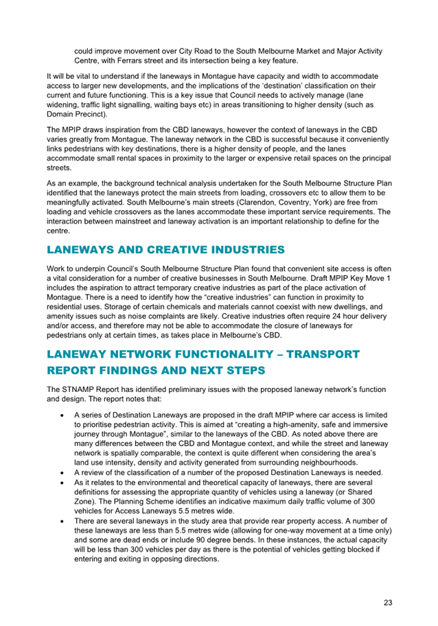
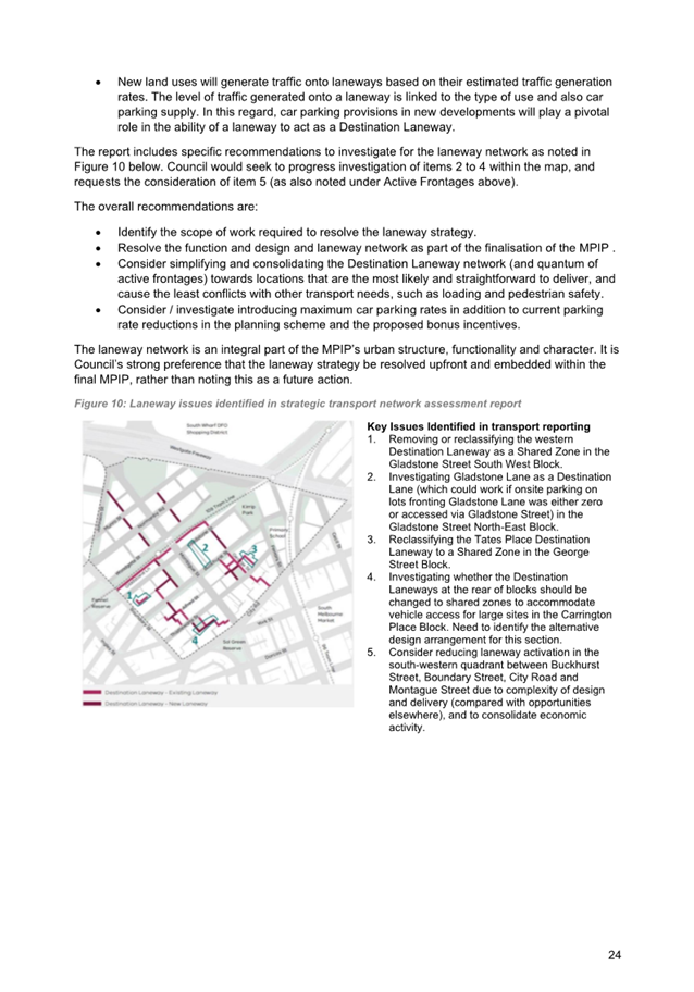
· Direction for the Street & Laneway Network – The MPIP is largely focused on streetscape character and the public realm but does not provide necessary details to deliver workable street and laneway designs. As far as practical, the MPIP should resolve the integrated street, laneway and parking functionality and design approach as part of this phase of work rather than as future actions. The plan’s recommendations must be informed by appropriate traffic modelling and resolve modal priorities for each street and laneway. Where the modal priorities necessitate changes to the street layout, concept plans should be prepared to ensure outcomes are tested with a level of rigour.
· Flooding and Water – Montague has significant flooding, sea level rise, storm surge and drainage issues that span the public and private realm. The MPIP highlights this as an issue, however it is silent on any short or long term changes to address the issue. The MPIP should incorporate an integrated water management approach, including the prioritisation of flood safety and mitigation measures in the MPIP’s active frontage and street design guidance and associated planning scheme controls. The proposed concept designs for streets and laneways do not consider or respond to the existing and proposed context of significantly raised ground floor levels across the precinct often required by Melbourne Water. This poses a challenge to the activation of street frontages and laneways if left unresolved.
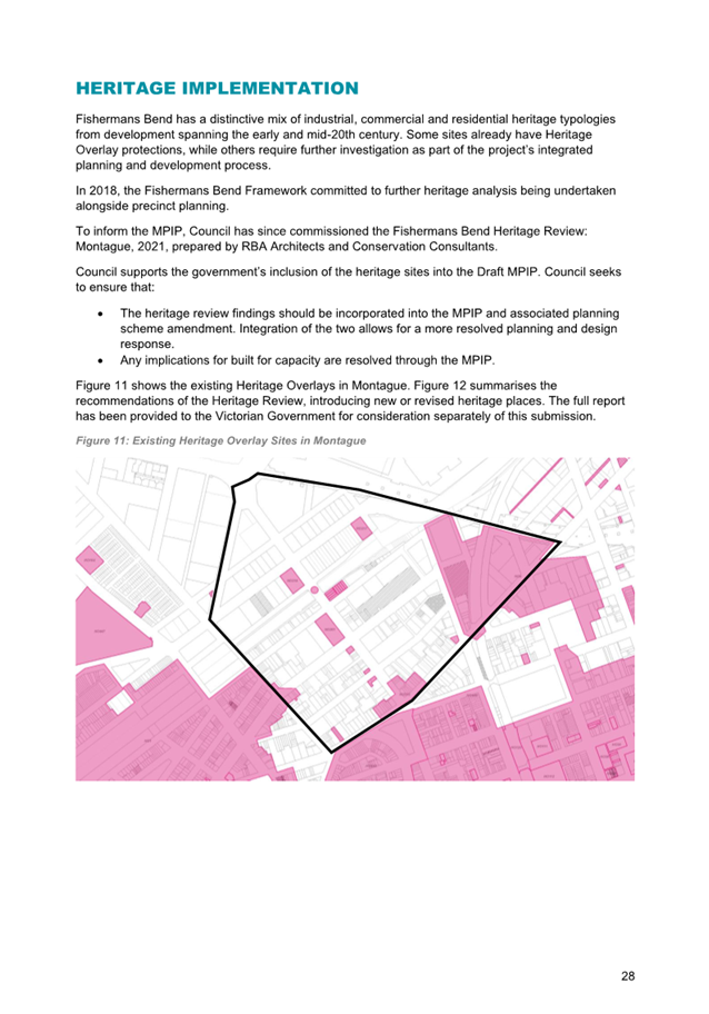
· Planning controls, heritage and character – Council understands that the next stage in the MPIP development process is to develop planning controls and consider approval pathways – however our assessment of the Draft MPIP has been constrained by not having this information. For example, the role of the MPIP in the planning scheme is not clearly defined, which will affect its scope; and several of the ideas presented in the plan are novel in the Victorian planning context raising concerns about how they can be implemented and enforced. Council is supportive of the plan’s ideas to protect and reinforce the industrial and commercial character in Montague, but the mechanisms to deliver this need clarification.
· Public Transport – The MPIP needs to investigate and communicate how its interventions support active and public transport improvements in Montague to deliver on the Fishermans Bend 80% active and public transport mode share target. Without public transport access improvements, and street design improvements, the sustainable transport goals will be undermined.
4.17 The submission includes a list of specific recommendations to address issues.
Council Submission – maintaining further involvement in plan development
4.18 Council collaboration and involvement in finalisation of the MPIP is vital. The submission will request:
· Involvement in any updates to the MPIP, planning scheme amendment and associated supporting material.
· Receipt and review of the planning controls that will form part of a planning scheme amendment that implements the MPIP.
· Receipt and review of the Making Montague supporting material prior to finalisation of the MPIP for the upcoming planning scheme amendment.
· Involvement in aligning the government’s DCP and MPIP processes and outcomes, noting that Council has made a separate submission to the Fishermans Bend DCP process.
5. CONSULTATION AND STAKEHOLDERS
5.1 The Victorian Government led the development of the Fisherman’s Bend Framework:
· The Fishermans Bend Strategic Framework Plan and associated planning scheme amendment was originally released in 2012.
· The Fishermans Bend Recast Vision was released in 2016.
· The Fishermans Bend Framework and associated planning scheme amendment was finalised in 2018.
5.2 The Victorian Government are leading community engagement on the Draft MPIP.
· Precinct Pre-planning engagement process was held in 2019.
· Draft MPIP was released for public consultation in 2023 (1 December 2023 to 23 February 2024).
· The next step in the process will be for the State Government to review submissions, finalise the MPIP and consider approval pathway options – Mid 2024.
· The likely next community consultation process will occur through the formal planning scheme amendment process to implement the Draft MPIP.
6. LEGAL AND RISK IMPLICATIONS
6.1 The Victorian Government is leading the development of the MPIP, and its implementation via planning scheme amendment.
6.2 The MPIP will ultimately:
· Update the land use and development framework and planning controls.
· Guide infrastructure planning and delivery.
This will assist Council in managing risks associated with on-going governance, decision-making, work programming and processes for Fishermans Bend. It will also help to mitigate emerging risks such as climate change.
7. FINANCIAL IMPACT
7.1 Council’s Fishermans Bend Program is resourced to respond to the Victorian Government’s MPIP project. This includes project funding for the future MPIP planning scheme amendment process, expected in 2024. This will generally cover legal and expert advisory costs associated with the amendment’s advisory panel process.
7.2 The development of the MPIP is led by the Victorian Government. Council’s submission notes several gaps and issues that require further work for the Government to resolve as part of finalising the Draft MPIP. The risk is that, if the MPIP is not scoped and resolved appropriately, this further work may fall upon Council to manage through future strategic, planning and design projects.
7.3 Other financial risks are related to infrastructure delivery. These risks are proposed to be addressed and responded to as part of Council’s separate response to Planning Scheme Amendment GC224 (Fishermans Bend Development Contributions Plan and Open Space Uplift Mechanism).
8. ENVIRONMENTAL IMPACT
8.1 The MPIP builds upon the eight sustainability goals of the Fishermans Bend Framework, including becoming a climate resilient, water sensitive, biodiverse, low carbon and low waste community.
8.2 Significant investment in infrastructure will be required to ensure that Fishermans Bend adapts to the challenges of climate change, particularly flooding and sea level rise, and to implement greening and water management infrastructure in our streets and public spaces that are necessary to create a safe and healthy community.
8.3 The State Government has set ambitious goals to reduce flood risks, improve water quality, minimise potable water use and increase canopy cover for Fishermans Bend to become Australia’s largest Green Star community. To achieve these goals, many of Council’s parks and streetscapes will be required to incorporate stormwater detention tanks, stormwater harvesting, water sensitive urban design, large canopy trees and vegetated areas, changes to levels and design of streetscapes and public spaces.
8.4 The Draft MPIP’s environmental content is high-level. Council’s submission has sought additional content on environment and sustainability for inclusion in the final MPIP.
9. COMMUNITY IMPACT
9.1 The MPIP is being developed with input from the community. The focus of the MPIP is to guide future change and growth in ways that protect and enhance community values and character, and ensure it remains a great place to live, work and play.
10. ALIGNMENT TO COUNCIL PLAN AND COUNCIL POLICY
10.1 This report is most aligned to the Liveable Port Phillip Strategic Direction within the Council Plan 2021-31. The coordination of precinct and infrastructure planning, forms part of the initiatives to:
· Partner with the Victorian Government to deliver outcomes in the Fishermans Bend strategic framework.
· Facilitate and advocate for the Victorian Government to develop a sustainable funding and financing strategy to enable the timely delivery of local infrastructure at Fishermans Bend and to provide early delivery of high frequency public transport links to Fishermans Bend.
11. IMPLEMENTATION STRATEGY
11.1 TIMELINE
· The Victorian Government is leading the development and public consultation process for the Draft MPIP.
· The Draft MPIP was released for public consultation in 2023 (1 December 2023 to 23 February 2024)
· The next step in the process will be for the Victorian Government to review submissions, finalise the MPIP and consider approval pathway options – Mid 2024.
· Council will seek confirmation of involvement in this process.
· The likely next community consultation phase will occur through the subsequent formal planning scheme amendment process to implement the Draft MPIP – dates to be confirmed.
11.2 COMMUNICATION
· The Victorian Government led the community consultation process for the Draft MPIP. This included material provided through the government’s online Engage Victoria website and Fishermans Bend website, letters to owners and occupiers in the precinct, social media campaigns and posts, meetings with land owners, business and industry briefings, and community information sessions.
12. OFFICER mATERIAL OR GENERAL INTEREST
12.1 No officers involved in the preparation of this report have any material or general interest in the matter.
|
ATTACHMENTS |
1. City of Port Phillip Submission - Draft Montague
Precinct Implentation Plan - Part A Submission Summary 2. City of Port Phillip Submission - Draft Montague
Precinct Implentation Plan - Part B Discussion Points |
|
Attachment 1: |
City of Port Phillip Submission - Draft Montague Precinct Implentation Plan - Part A Submission Summary |

|
City of Port Phillip Submission - Draft Montague Precinct Implentation Plan - Part B Discussion Points |


Meeting of the Port Phillip City Council
20 March 2024
|
10.4 |
Council Submission to the Victorian Government's Fishermans Bend Urban Renewal Area Development Contributions Plan (Planning Scheme Amendment GC224) |
|
Executive Member: |
Brian Tee, General Manager, City Growth and Development |
|
PREPARED BY: |
Gareth Nevin, Senior Program Manager Fishermans Bend |
1. PURPOSE
2. EXECUTIVE Summary
2.1 The Victorian Government’s proposed Draft Planning Scheme Amendment GC224 proposes a Fishermans Bend Urban Renewal Area Development Contributions plan (DCP), Open Space Uplift mechanism (OSU) and associated planning scheme controls.
2.2 Council’s Amendment submission has been developed in two stages:
2.2.1 The preliminary submission was endorsed by Council at its meeting on 06 December 2023 and subsequently provided to the State Government.
2.2.2 The full submission (now presented for Council endorsement) was developed based on the preliminary submission and further analysis undertaken during the community consultation period.
2.3 While broadly supportive of the proposed approach to secure funding for infrastructure in Fishermans Bend, the submission is critical of several matters, set out thematically in the submission that require further resolution through the amendment process, including: the approach to integrated planning and infrastructure strategy; a major local infrastructure funding gap (preliminarily estimated to be at least $600 million); allocation of project funding for open space, community hubs, drainage and transport projects; and details within the planning provisions.
|
That Council: 3.1 Endorses the City of Port Phillip submission to Draft Planning Scheme Amendment GC224 - Fishermans Bend Development Contributions Plan and Open Space Uplift mechanism (Attachment 1). 3.2 Notes that the submission will form the basis of the City of Port Phillip’s engagement with the Department of Transport and Planning, in the interest of resolving issues where possible prior to a Precincts Standing Advisory Committee. 3.3 Authorises the CEO, or their delegate, to make administrative changes and correct any errors, that do not materially affect the intent of the submission, prior to submission to the Department of Transport and Planning. 3.4 Authorises the CEO, or their delegate, to make adjustments to the submission and subsequent advocacy before the Precincts Standing Advisory Committee process as necessary if further information on the draft DCP or the draft Amendment GC224 transpires through the process consistent with the thrust of Council’s endorsed submission provided Council is kept briefed on those changes. 3.5 Requests the Department of Transport and Planning to release the updated scope and cost information that has formed the basis of the draft Development Contributions Plan projects in sufficient time to enable them to be reviewed by Council and other submitters. 3.6 Requests the Mayor write to the Victorian Government seeking a commitment to the eventual funding and delivery of the Fishermans Bend Tram servicing the Sandridge and Wirraway Precincts. 3.7 Requests the CEO, or their delegate, to write to the Victorian Government seeking commitments to: 3.7.1 release a comprehensive funding and finance strategy for all infrastructure classifications and categories. 3.7.2 release the updated scope and cost information that has formed the basis of all draft DCP projects in sufficient time to enable them to be reviewed by Council and other submitters. 3.7.3 development of an updated Fishermans Bend Partnership Agreement, and an infrastructure governance and implementation strategy. 3.7.4 confirmation of process, timeframes and eventual funding for the delivery of catalytic infrastructure, including the Fishermans Bend tram and Melbourne Metro 2. 3.7.5 Collaborative development and finalisation of the Montague, Sandridge and Wirraway Precinct Implementation Plans, and a commitment to the review and update of any approved DCP as part of the Precinct Implementation Plan processes. |
4. KEY POINTS/ISSUES
Background
4.1 Fishermans Bend is Australia’s largest urban renewal project, covering 480 hectares of land located in the heart of Melbourne. The Fishermans Bend Framework (Framework) was released by the State Government in 2018, providing a plan for the area’s transformation to an area housing 80,000 residents and providing employment for up to 80,000 people.
4.2 The Framework is the State Government’s plan for a network of parks, schools, roads, transport and community facilities and services to transform Fishermans Bend into a precinct for residents and employment over the next 30 years. As Australia’s largest urban renewal precinct, the scale and extent of expected transformation is unprecedented.
4.3 The Framework was implemented in the Port Phillip and Melbourne Planning Schemes in 2018. It outlines the key infrastructure required to support the urban renewal of the precinct, and the need for a detailed infrastructure plan and funding strategy for its implementation.
Overview of the Amendment
4.4 Draft Planning Scheme Amendment GC224 (‘the Amendment’) is proposed to implement the ‘Fishermans Bend Urban Renewal Area Development Contributions Plan’ (‘the DCP)’ and the ‘Fishermans Bend Open Space Uplift mechanism’ (‘the OSU)’ by introducing new planning provisions into the Port Phillip and Melbourne Planning Schemes for the four Capital City zoned precincts of the Fishermans Bend Urban Renewal Area. The amendment can be accessed online via the Engage Victoria Website:
https://engage.vic.gov.au/fishermans-bend-urban-renewal-area-development-contributions-plan
What is the DCP mechanism?
4.5 A Development Contributions Plan (DCP) is a planning scheme mechanism for funding basic and essential infrastructure required by a new community. The Draft Fishermans Bend DCP proposes to fund approximately $2.45 billion of what is deemed ‘essential infrastructure’ in Fishermans Bend, including open space, community hubs, transport projects, and drainage projects. The funded infrastructure projects are shown in the summary map below, extracted from page 10 of the Draft DCP.
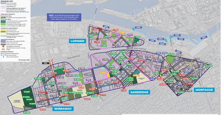
What is the OSU Mechanism?
4.6 To complement the Draft DCP, the State Government proposes an ‘Open Space Uplift’ (OSU) planning mechanism to create a development incentive to help fund land for parks. The OSU mechanism would enable a ‘density bonus’ (allowing for additional approved dwellings) where developers agree to provide land designated in the Framework for public open space. A total of 21 OSU candidate sites have been nominated across the precinct (16 are within the City of Port Phillip precincts). These sites have been tested to confirm capacity to deliver open space on site and accommodate additional dwelling density, within existing built form planning controls. The OSU relies on providing an incentive, much like the current social housing uplift, where developers would make the land contribution to achieve additional yield. The OSU and the Social Housing Uplift, which already exists in the scheme, are to operate concurrently.
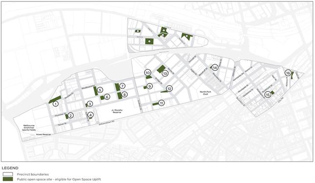
How has the State Government approached infrastructure funding via the DCP and OSU?
4.7 State Government entities are nominated as ‘Development Agency’ and ‘Collecting Agency’ for the DCP, meaning that the State Government is taking leadership and responsibility for the collection of DCP contributions, the delivery of the associated projects, and associated risks.
4.8 The DCP proposes a single state-administered Development Infrastructure Levy (DIL) that integrates contributions towards community infrastructure, open space, and major drainage and flood mitigation infrastructure into a single consolidated charge. Major drainage projects have been integrated into the DCP to avoid the need for a separate urban renewal cost recovery charge/development services scheme. This will ensure that development is levied once, and contributions are consolidated into one fund managed by the State.
4.9 The DCP identifies three categories of infrastructure, with ‘Essential infrastructure’ being the focus of the DCP funding:
4.9.1 ‘Catalytic infrastructure’ – includes public transport, schools, and health services that will have a transformational effect on the urban renewal of the area. This infrastructure is intended to be funded and delivered by State Government.
4.9.2 ‘Essential infrastructure’ – includes infrastructure required to establish the future urban structure of the area, such as precinct and neighbourhood open spaces, streets that make up the key movement network, key community hubs, and major drainage and flood mitigation infrastructure. This infrastructure is intended to be largely funded by development contributions, with some contribution from other government sources such as local government.
4.9.3 ‘Local infrastructure’ – includes some open spaces, the network of minor streets and laneways and other community facilities. This infrastructure is intended to be funded and delivered through a combination of works normal to the development of sites and incrementally by local government capital expenditure.
4.10 It is noted that:
4.10.1 The DCP proposes a capped Development Infrastructure Levy (DIL) charge of approximately $34,635 per dwelling and $286 per square metre of non-residential gross floor area (both adjusted annually). The levy has been identified by the State Government as an amount that is feasible for developers and that will not affect development uptake. The levy generates a natural budget limitation on how much infrastructure can be funded by the DCP.
4.10.2 The DCP will fund approximately $2.45 billion of infrastructure projects. Forecast DCP revenue is estimated as approximately $1.7 billion (based on the DIL charge and forecast development uptake), resulting in an estimated shortfall of at least $700 million. Council understands that the revenue shortfall will be the responsibility of the State Government to manage. How this shortfall is managed may affect other authorities including Council, as the timing and accumulation of revenue will impact on infrastructure delivery decisions over the life of the DCP.
4.10.3 Some land required for open space projects that are a necessary part of the open space network are to be delivered through the OSU mechanism. The value of that land has not been identified in the Amendment, although it applies to 21 sites and is in addition to the approximate $2.45 billion cost estimate set out in the DCP. That land is effectively “paid for” by providing increased development rights to certain landowners. The success of this mechanism will depend on whether it provides an appropriate level of incentive for the uptake.
Key Issue – Information Gaps
4.11 The draft DCP has not been accompanied by the following information and strategies, which are important to ensure that Council and our community has a clear understanding of the DCP and associated infrastructure commitments. These are relevant to the DCP process itself, and the broader infrastructure planning requirements in Fishermans Bend.
4.11.1 A comprehensive funding and finance strategy – this is critical to identify funding and delivery pathways for all infrastructure classifications, including those within and separate of the DCP, and to provide greater certainty for all agencies and landowners involved in delivering infrastructure.
4.11.2 A governance partnership and implementation strategy – Council requires an understanding of how the government intends to manage the delivery of infrastructure. There is a need for to resolve governance and implementation requirements through parterships and strategies that identifies the role of all agencies in the future work, including the prioritisation, planning, design and delivery of infrastructure.
4.11.3 Detailed DCP cost information – While some cost information has been released alongside the Amendment package, the information is not clear. Further clarity about project scope and cost information should be provided ahead of the advisory committee process to ensure that individual projects can be appropriately assessed by Council and other interested parties.
4.11.4 Commitments, or at minimum baseline assumptions, about public transport delivery and integration – to provide context for the assessment of relevant DCP proposals.
4.12 The DCP was released alongside the Montague Precinct Implementation Plan (MPIP), and this iterative process has assisted in informing the DCP.
4.13 The DCP has been prepared in absence of Precinct Implementation Plans (PIPs) for Sandridge, Wirraway and Lorimer Precincts. A commitment from the government to work with the City of Port Phillip is required, to complete the PIP work and to incorporate its outcomes into the Planning Scheme and the Development Contributions Plan at key milestones. It is important that the development of the DCP and the PIPs follow an iterative but aligned process. There is an opportunity to initially align the ongoing work on the MPIP with the current DCP process. There should be a commitment to review and if necessary update any approved DCP upon the finalisation of the other Precinct Implementation Plans which are likely to follow the current DCP process.
Key Issue – Funding gap for essential and local infrastructure
4.14 A key concern for Council is that the State Government has developed and released the DCP without an appropriate analysis of the implications for the funding and delivery of excluded ‘Local Infrastructure’. Local infrastructure is a key element of the Fishermans Bend vision and is likely to provide more tangible community benefit if delivery is enabled by funding than a number of projects which are currently funded by the DCP but unlikely to be delivered in the time frame of the DCP.
4.15 A significant component of the Local infrastructure is not funded in the DCP, leaving a funding gap for Council and contributing to the delay in its delivery (assuming if it is delivered at all). The extent of this gap has not yet been finally quantified, but preliminarily estimates identify this to be at least $600 million. Taking into account the statutory Financial Management Principles embedded in the Local Government Act 2020 Council is unable to commit to fund the likely shortfall in funding for Local infrastructure.
4.16 The submission identifies Local infrastructure projects that should be included in the DCP for funding and identifies infrastructure projects funded by the DCP that should be removed to make space for the funding of Local infrastructure projects that are considered Essential.
4.17 Other core concerns identified in the submission include:
4.17.1 The Fishermans Bend Framework vision effectively applies to all land and infrastructure, while the Fishermans DCP and OSU provide a funding pathway for only some of this infrastructure, leaving a significant and unaddressed gap.
4.17.2 A key assumption of the DCP is that, in addition to infrastructure funded via the DCP, other infrastructure will be funded through alternative sources including Council rates and charges, planning permit conditions and/or voluntary s.173 agreements with developers.
4.17.3 Council has limited ability to fund infrastructure. Council currently allocates around 5% of rates revenue to new and expanded capital projects. The allocation from the projected rates in Fishermans Bend between 2025-55 will generate between $31 million and $66 million depending on speed at which the projected development occurs. Additional Council investment is required for major urban renewal projects. However, even if the Council allocation was doubled to 10%, the available funding of between $66 million and $143 million over time, is insufficient to meet the component of the local infrastructure which is not funded by the DCP and which will be required to be provided by local government (estimated to be at least $600 million).
4.17.4 A major risk is the funding framework’s reliance on planning permit conditions and voluntary s.173 agreements to fund local infrastructure that is not funded by the DCP, such as improvements to local roads and the creation of new local roads and lanes. A concern is that the potential for funding and infrastructure delivery from these sources and mechanisms is over estimated, especially in the context of current legislative constraints. This is due to difficulties in negotiating local upgrades separately of proposed DCP contribution requirements, and aligning expectations between the Fishermans Bend vision and what can be determined as a necessary as a result of the grant of the permit (per section 62(5)(c) of the Planning and Environment Act 1987) and other revenue constraints imposed by those provisions.
4.17.5 A concern is that without a clear funding pathway within the DCP for local infrastructure projects, and without stronger planning provisions requiring upgrades via other mechanisms (including works normal to development), important infrastructure will not be delivered, or will be delivered in a form that is adhoc and does not meet the Fishermans Bend vision.
4.17.6 The funding shortfall represents a material risk to the success of Fishermans Bend vision, and undermines the place making assumptions of the Framework and the forthcoming precinct planning processes.
Council Submission – Summary
4.18 The following is a brief summary of the main points raised in the Council submission (Attachment 1). The submission itself provides further context to these points.
Preliminary
4.19 Recognises the scale and extent of the transformational change expected in Fishermans Bend and welcomes the State Government’s leadership in preparing the Amendment.
4.20 Emphasises the Council’s concern that integrated planning is critical, and the ability to provide the infrastructure required is a shared responsibility. The Council would like to see a proactive and committed response from the State Government in relation to the delivery of critical elements of the infrastructure.
Public Transport
4.21 Seeks clarity and commitment from the State Government for delivery of critical public transport including the Melbourne Metro 2, the southern tram connection (Plummer St corridor) and a tram service between Fishermans Bend and the CBD. The provision of public transport is a fundamental element in the success of Fishermans Bend as envisaged by the Framework.
4.22 Submits that allocations within the DCP to facilitate or associated with the public transport improvements should not be funded through the DCP.
Local Infrastructure Funding Shortfall
4.23 Details the significant funding shortfall for ‘Local’ infrastructure which will become the Council’s responsibility under the proposed Amendment. The submission seeks to re-prioritise aspects of the DCP funding to deliver core ‘Essential’ and ‘Local’ infrastructure through the DCP, elements that will not otherwise be able to be funded by Council.
4.24 The funding changes proposed in the submission include: additional open space, Community Hubs projects, decreased and rearranged transport projects, resulting in a reduced funding gap for local infrastructure of at least $257 million based on comparable and preliminary estimates.
Open Space Funding
4.25 Supports the OSU mechanism in principle to achieve the provision of 21 open space areas but is concerned about (1) feasibility and uptake and (2) delivery implementation. There needs to be a clear Plan ‘B’ to obtain the open space where a developer does not wish to utilise the mechanism. Funding for this is not provided in the DCP.
4.26 Recommends several changes to land and construction funding within the DCP across the open space network.
4.27 Proposes cost updates for sports infrastructure, based on future sports demand and supply analysis and concept planning, which impacts construction costs and timing.
4.28 Proposes costs updates for other construction / embellishment matters including the standardisation of open space requirements, sporting infrastructure requirements, greening requirements, and integrated water management requirements.
4.29 The submission notes that open space is at capacity and the planning and delivery of new and upgraded open spaces within the Phase 1 (first 10 years) of delivery is paramount. The submission seeks Phase 1 delivery of North Port Oval Expansion (former Australia Post site), Elder Smith Reserve upgrades, and the potential for funding of Montague North or Wirraway North.
4.30 Makes recommendations in relation to land and construction costs and staging for the North Port Oval Expansion (former Australia Post site).
Community Hub Funding
4.31 Recommends additional DCP funding to deliver Montague Arts and Cultural Hub, Sandridge Sports and Recreation Hub (with an increased scope) and the delivery of local Community Facilities in schools.
Drainage Project Funding
4.32 There is a concern that flood modelling and drainage assets need to be reviewed and the submission requests that the State Government prepare an updated flood modelling and drainage strategy to inform DCP projects. It is expected this will have implications for drainage and road projects in the DCP.
4.33 Requests that the full estimated cost for Integrated Water Management and distributed storage projects is accounted for in the DCP, and that the approach to drainage costing in the DCP is clarified.
Transport Project Funding
4.34 Notes the unresolved and significant funding shortfall for local transport infrastructure that is present in the Draft DCP’s current funding approach.
4.35 Proposes a reprioritisation of proposed projects for DCP funding to ensure that local street infrastructure is adequately prioritised in the DCP, including:
4.35.1 Prioritisation of DCP funding for key existing local streets, some of which, are not currently funded in the DCP but will require transformative upgrades to meet the Fishermans Bend vision
4.35.2 Re-prioritisation of DCP funding for new streets in the core vehicle movement network.
4.35.3 Additional intersections and crossings to improve safety outcomes
4.35.4 Excluding funding for State roads, public transport projects or bridge upgrades, which have other State funding opportunities.
4.35.5 Reconsideration of DCP funding for identified new mid-block streets which Council considers to be of secondary importance to the realisation of the Framework vision and are not core to the broader movement network. These new streets are identified for funding in the Draft DCP, but require a substantial proportion of transport project funding, and could potentially be delivered in alternative forms or not delivered if deemed appropriate based on further review in context of the DCP’s budget-constrained environment. The submission notes this as an unresolved issue for consideration through the amendment process. Should it remain unresolved the new streets should be provided with DCP or other State Government funding.
4.36 Requests clarification about transport project scope and cost, as the information provided with the DCP is unclear.
4.37 Raises concerns that road and intersection projects appear to be under-scoped or under-funded.
4.38 Notes that there are several transport projects which are not funded in the DCP or recommended for reconsideration based on Council’s submission. Notes that alternative funding sources will need to be identified for the remainder of projects in finalising the DCP so that there is a clear path for DCP funded and unfunded infrastructure.
Planning Provisions
4.39 Requests further information and changes to the Capital City zone to ensure the Social Housing Uplift is fully achieved on sites also using the Open Space Uplift.
4.40 Requests that the open space provided through the OSU is remediated prior to hand over.
4.41 Requests clarification that linear parks will be funded within road reserve upgrades, as mapping is unclear in the DCP and controls.
4.42 Seeks clarification of future open space land ownership and land remediation standards for land voluntarily contributed through the OSU mechanism.
4.43 Requests several minor and technical changes to the Design and Development Overlay to clarify the controls.
4.44 Requests clarification of the operation of the Incorporated Plan Overlay (IPO) particularly in relation to open space, road provision and uplift provisions, the Development Contributions Overlay and the referral authority provisions at Clause 66.04.
5. CONSULTATION AND STAKEHOLDERS
5.1 The State Government has exhibited the Draft Amendment in accordance with statutory requirements. Affected owners and occupiers were notified. All submissions to the Amendment were directed to the State Government through the Fishermans Bend taskforce or Engage Victoria.
5.2 While the Department of Transport and Planning will seek to resolve issues raised by submitters including Council, unresolved issues or particular matters requiring further consideration may be referred to the Precincts Standing Advisory Committee (SAC). Should the Minister for Planning seek to refer unresolved matters to the Precincts SAC, Planning Panels Victoria will contact affected submitters regarding next steps, process and timings.
6. LEGAL AND RISK IMPLICATIONS
6.1 The Draft Planning Scheme Amendment will be processed in accordance with the Planning and Environment Act 1987. The Advisory Committee will be appointed pursuant to part 7, section 151 of the Planning and Environment Act 1987 to advise the Minister for Planning and the Minister for Projects on referred projects and plans and associated draft planning scheme amendments.
6.2 The Amendment content presents a material risk at a strategic, financial and reputational level for Council, relating to whether the State Government and Council can deliver the Fishermans Bend Framework and vision.
7. FINANCIAL IMPACT
7.1 Costs of preparing the submission to the Amendment and the Advisory Committee process will be funded through the existing Fishermans Bend Program budget for 2023/24FY and 2024/25FY.
7.2 The financial impact of the Draft DCP Amendment for Council are substantial and covered under Key Points/issues. In summary:
7.2.1 There is a significant funding shortfall for Local Infrastructure for which Council will be primarily responsible to fund, initially estimated to be at least $600 million based on broad assumptions.
7.2.2 Council has limited ability to fund infrastructure. Council currently allocates around 5% of rates revenue to new and expanded capital projects. The allocation from the projected rates in Fishermans Bend between 2025-55 will generate between $31 million and $66 million depending on speed at which the projected development occurs. Additional Council investment is required for major urban renewal projects. However, even if the Council allocation was doubled to 10%, the available funding of between $66 million and $143 million over time, is insufficient to meet the component of the local infrastructure which is not funded by the DCP and which will be required to be provided generally by local government.
7.3 The Council submission identifies alternate funding priorities that include: additional open space projects, additional Community Hubs projects, and decreased and rearranged transport projects, resulting in a reduced funding gap for local infrastructure of at least $257 million based on comparable and preliminary estimates.
7.4 The State Government is proposing the new DCP as the primary means of imposing levies for the delivery of key infrastructure projects including open space and other infrastructure. Part of the proposal involves deleting Council’s Open Space Contribution in Fishermans Bend and effectively absorbing those projects and collection funds into the DCP levy.
7.4.1 Council currently receives an 8% (of the Site Value) public open space contribution for development in Fishermans Bend.
7.4.2 Council will continue to receive open space contributions on all permits granted prior to the gazettal of the proposed DCP, which is anticipated to be not before late 2024/25.
8. ENVIRONMENTAL IMPACT
8.1 The proposed DCP provides funding for infrastructure that delivers environmental benefits such as public realm greening and flood mitigation. The submission identifies recommended further allocations or changes.
9. COMMUNITY IMPACT
9.1 The DCP will provide funding for infrastructure to meet the needs of the future population. The submission identifies areas that require additional funding or other changes.
10. ALIGNMENT TO COUNCIL PLAN AND COUNCIL POLICY
10.1 This report is most aligned to the Liveable Port Phillip Strategic Direction within the Council Plan 2021-31. The coordination of infrastructure funding and financing, including through the proposed Development Contributions Plan, forms part of the initiatives to:
Partner with the Victorian Government to deliver outcomes in the Fishermans Bend strategic framework.
Facilitate and advocate for the Victorian Government to develop a sustainable funding and financing strategy to enable the timely delivery of local infrastructure at Fishermans Bend and to provide early delivery of high frequency public transport links to Fishermans Bend.
11. IMPLEMENTATION STRATEGY
11.1 TIMELINE
11.1.1 The State Government has advised that potential dates for the Precincts Standing Advisory Committee are reserved for :
Directions Hearing: week commencing 15 April 2024
Hearing: week commencing 27 May 2024
11.2 COMMUNICATION
11.2.1 A Draft submission has been provided to the State Government to meet the submission deadline of 23 February, 2024. The adopted submission will replace that Draft submission.
12. OFFICER MATERIAL OR GENERAL INTEREST
12.1 No officers involved in the preparation of this report have any material or general interest in the matter.
|
ATTACHMENTS |
1. City of Port Phillip Submission - Fishermans DCP and
OSU - Amendment GC224 |
Meeting of the Port Phillip City Council
20 March 2024
|
E-scooter Trial Update |
|
|
Executive Member: |
Brian Tee, General Manager, City Growth and Development |
|
PREPARED BY: |
Karen Roache, Coordinator Strategic Transport |
1. PURPOSE
1.1 To update Councillors on the current State Government e-scooter trial
1.2 Request further delegation to the CEO to enter into interim agreements for continuation of the shared e-scooter services whilst procurement is undertaken should the State Government determine to end the trial and legalise e-scooters.
2. EXECUTIVE Summary
2.1 Outcome 5 of Council’s Integrated Transport Strategy highlights the community benefits of new transport options and technology to move around, noting that these benefits rely on partnering with the Victorian Government and other councils to regulate, promote and manage these transport options (Action 38).
2.2 In 2019 Port Phillip was the first Victorian Council to support trialling a shared e-scooter scheme and the subsequent Victorian Government led trial of e-scooters in City of Port Phillip, Yarra and Melbourne commenced in February 2022 and, after several extensions, was due to end on 5 October 2023.
2.3 At the 4 October 2023 Council meeting the following recommendations were unanimously carried (the October 2023 motion).
That council:
1. Notes the feedback on the trial including uptake and safety and amenity concerns raised in this report.
2. Request that the Mayor write to the Ministers for Roads and Road Safety Public requesting the public release of the Victorian Government e-scooter trial evaluation.
3. Endorses Council’s continued participation in e-scooter schemes provided that Councils have the power to manage shared e-scooter schemes through contractual arrangements that can address safety and amenity.
4. Authorises the Chief Executive Officer (or their delegate) to undertake any procedures required to allow participation in a three-year shared e-scooter scheme with up to two operators and (subject to agreement with Council) a maximum of 500 e-scooters including, in collaboration with other councils.
2.4 On 6 October 2023, a further extension of the trial until 5 April 2024 was announced by Minister for Roads and Road Safety (Hon Melissa Horne MP) and the Minister for Public and Active Transport (Hon Gabrielle Williams) who will now oversee the trial outcome.
2.5 In line with Item 2 of the October 2023 motion, the Mayor has corresponded with the relevant ministers requesting the public release of the trial evaluation.
2.6 In line with Item 3 of the October 2023 motion, in November 2023 the Victorian Parliament passed the Transport Legislation Amendment Act 2023 providing local governments (LGA) the power to require shared mobility scheme operators, such as e-scooters and e-bikes, to enter into an agreement with the LGA before launching services operating on public land. Amendments relating to shared schemes require royal proclamation prior to coming into effect (most likely at the end of the trial).
2.7 Since the trial began e-scooter usage has seen a median of 1291 trips per day, with over 1 million trips finishing in our city. From February 2022 to 31 January 2024 over 7 million individual e-scooter trips had been taken on the 2500 shared e-scooters across Melbourne (500 e-scooters are located in Port Phillip).
2.8 A December 2023 published academic paper reviewed the injury impact of e-scooters in 2022 at the emergency department at Royal Melbourne Hospital (RMH).
2.9 The injury rates in Melbourne are in line with the experience of other Australian and New Zealand cities with shared e-scooter schemes and we have seen a decrease in the accident rates reported to operators in Port Phillip.
2.10 City of Port Phillip’s agreements with e-scooter operators expire on the 5 April 2024 and, should the Victorian Government trial end at this time, and e-scooters continue to operate in Victoria, existing agreements with operators would be required for the period between the end of trial and conclusion of the procurement process to determine who will provide e-scooter services. This report recommends delegation to the CEO to enable the continuation of the service until the procurement process is completed and new agreements have been entered.
2.11 Council seeks to establish a process for new agreements in collaboration with the Cities of Melbourne and Yarra who are yet to finalise their position in terms of an ongoing role with e-scooters.
|
That Council: 3.1 Notes that the Mayor has written to the Minister for Roads and Road Safety and the Minister for Public and Active Transport requesting the public release of the evaluation report for the e-scooter trial. 3.2 Notes the update to the Victorian Government led e-scooter trial including legislative changes that, once proclaimed, will empower Councils to manage shared e-scooter schemes through contractual arrangements that can address safety and amenity. 3.3 Notes that the e-scooter trial is due to end on 5 April 2024 and that, at the completion of the trial on 5 April 2024 or some other date as determined by the Victorian Government, Council will commence a procurement process to determine which e-scooter providers will operate in the City of Port Phillip and under what conditions. 3.4 Authorises the Chief Executive Officer (or their delegate) to extend existing agreements with e-scooter operators until the procurement process and transition to a new shared e-scooter agreement is completed. |
4. KEY POINTS/ISSUES
Legislative Changes
4.1 In November 2023 the Victorian Parliament passed the Transport Legislation Amendment Act 2023 which gave local government the authority to manage shared mobility.
4.2 Specifically, the Road Safety Act 1986 section 55:7C 90S states
‘A person must not make a relevant vehicle available for hire under a vehicle sharing scheme unless the person is a party to an authorising agreement with the municipal council that governs the municipal district in which the relevant vehicle is located’.
4.3 This provision comes into effect upon proclamation which is anticipated if the trial is concluded on 5 April 2024 and e-scooters are to remain legal in Victoria.
Hospitalisation and incident data
4.4 A recently published academic paper (December 2023) reviewed the injury impact of e-scooters in 2022 at the emergency department at Royal Melbourne Hospital (RMH).
4.5 Below is a summary of key points from the RMH study:
· 256 incidents related to e-scooters were recorded at RMH in the calendar year 2022 (243 within the shared e-scooter trial period) comprising 247 riders of e-scooters and 9 pedestrians
· Alcohol was a reported factor in 34% of incidents
· 33% of patients reported wearing a helmet
· Men in their late twenties or early thirties were overrepresented in the incidents
· 47% of total presentations to emergency were hospitalised, 53% were discharged from emergency department
· Most common injuries affected the upper limbs (53%) and head (50%)
· Abrasions made up 75% of injuries with fractures at 48%
· The median cost per patient was $1321
4.6 The information captured in the study did not distinguish whether the injury happened while using a shared or a privately owned e-scooter.
4.7 Officers have undertaken a comparison to other Australian and New Zealand Injury Studies seeking to select comparable cities with similar features.
4.8 The review of studies found:
· Melbourne injury rate (4.10 injuries per 100,000 trips) was lower than other Australian or New Zealand cities (8.09 Auckland and 9.31 Hobart) on a per 100k trip basis. Data available for Brisbane did not provide a breakdown by severity.
· Alcohol involvement was in line with Australian or New Zealand cities
· Helmet compliance of those in accidents was similar to Australian or New Zealand cities
Hospital presentation study comparison
|
City / Municipal Area |
Start |
End |
Months |
Injuries |
Admitted to (H) |
Trips |
Injuries per 100k trips |
Inj (sev) per 100k trips |
|
Melbourne (CoM, CoPP, CoY) |
1/02/2022 |
31/12/2022 |
11 |
243* |
114 |
2,776,302 |
8.25 |
4.10 |
|
Brisbane |
1/01/2022 |
31/12/2022 |
12 |
402 |
N/A |
3,269,300 |
12.30 |
0.00 |
|
Auckland |
22/10/2018 |
19/02/2019^ |
4 |
180 |
60 |
741,929 |
24.26 |
8.09 |
|
Hobart |
1/01/2022 |
30/06/2022 |
6 |
135 |
31 |
333,068 |
40.53 |
9.31 |
*Trial began so only 11-month period of injuries was relevant. ^Trip Numbers were Nov-18 to Feb-19
4.9 As part of the mandatory reporting requirements in the Commercially Operated Share Scheme (COSS) agreement, e-scooter operators are required to report minor, moderate, serious, and critical incidents to Council including location where known. Minor incidents do not require hospital treatment (scrapes and bruises), moderate incidents require outpatient hospital treatment and serious incidents require inpatient hospital treatment (e.g., fracture, concussion, or surgery).
4.10 Across the metro trial areas, operators reported 382 incidents in 2022 and 349 in 2023. This information is reliant on notification by riders, community members, or in device alerts to operators so may not be a complete data set.
4.11 Between 1st February to 31 December 2022, 76 incidents were reported to operators in CoPP. Of these 28 were classified as minor injuries, 6 moderate and 3 serious (requiring hospitalisation). An additional 39 were reported by operators as unknown, despite operator attempts to follow up with riders.
4.12 For the calendar 2023 calendar year City of Port Phillip saw a decrease on accident rates reported to operators with a total of 41 reports (24 minor, 6 moderate, 1 serious and 10 unknown).
4.13 The decision as to whether e-scooters (private and/or shared) safely integrate with the transport network in Victoria lies with the Victorian Government who have the jurisdiction to enact any legislative and regulatory changes.
4.14 Councils' powers to regulate the safety and amenity of e-scooters is limited to shared schemes and not privately owned e-scooters where we have very limited control.
4.15 As the trial has evolved, strategies have been developed to improve safety and amenity of e-scooter riders and the wider residential and visitor community of Port Phillip.
4.16 Most recently, cognitive testing has been introduced every Friday and Saturday night between 10pm and 4am for riders of shared e-scooters in specific . This in-application reaction time test has to be passed prior to commencing a ride. This acts as a screen against people trying to ride while intoxicated.
Future Approach
4.17 At the Ordinary Council meeting on 4 October 2024 and upon completion of the trial, Council supported participation in an ongoing shared e-scooter scheme provided that Councils have the power to manage shared e-scooter schemes through contractual arrangements that can address safety and amenity.
4.18 At this time Council authorised the Chief Executive Officer (or their delegate) to undertake any procedures required to allow participation in a three-year shared e-scooter scheme with up to two operators and (subject to agreement with Council) a maximum of 500 e-scooters including, in collaboration with other councils.
4.19 Officers continue to address any safety and amenity issues that result from the use of shared e-scooters including the review of hospitalisation and incident data and trialling of new technology in partnership with operators. This includes cognitive testing, parking beacons to minimise footpath obstruction, footpath detection technology on some devices to address this concern.
4.20 Prior to commencement in the trial, City of Melbourne led a tender process in partnership with Cities of Port Phillip and Yarra for the provision of shared e-scooter services by two operators. The Cities of Melbourne and Yarra are yet to finalise their involvement in any future scheme. It is anticipated that this will be done by mid 2024 and, if endorsed, a joint procurement processes can commence.
4.21 As noted in the 4 October 2023 Council report, to minimise disruption for users of the shared e-scooter service during the procurement of a future shared e-scooter scheme requires extending current arrangements with operators until new agreements are in place.
4.22 The procurement process would include addressing safety and amenity standards through operational and technological approaches. Market sounding prior to procurement will help ensure best practice technology, performance measurement and contractual provisions for shared e-scooter service are attained.
4.23 The Council decision of 4 October 2023 does not explicitly authorise the CEO (or their delegate) to continue with existing arrangements with operators at the completion of the trial to enable the procurement of a future scheme and transitioning to a new agreement, possibly with new operators. This update report seeks to remove this ambiguity.
5. CONSULTATION AND STAKEHOLDERS
5.1 Council has written to Minister for Roads and Road Safety (Hon Melissa Horne MP) and the Minister for Public and Active Transport (Hon Gabrielle Williams) requesting information relating to the trial and the evaluation results be made public.
6. LEGAL AND RISK IMPLICATIONS
6.1 Council Officers continue to review risks to Council throughout the trial.
7. FINANCIAL IMPACT
7.1 The current agreement with operators provides Port Phillip annual revenue of $182,000 (based on $1 per scooter per day and a maximum of 500 e-scooters). This recovers officer time and other costs associated with management of the scheme.
7.2 Best practice funding models will be explored in a marketing sounding exercise.
8. ENVIRONMENTAL IMPACT
8.1 Reduction of community greenhouse gas emissions will require attractive sustainable transport options to achieve a shift away from private vehicle trips.
8.2 Operator surveys and DTP estimates are that at least 30 per cent of scooter trips replace car journeys, This suggest riders in Port Phillip have saved approximately 108 tonnes of greenhouse gas emissions since the trial commenced.
9. COMMUNITY IMPACT
9.1 E-scooters offer an affordable transport option for residents and visitors to access businesses, work, destinations and events across our city.
9.2 Many people have used the shared e-scooters with over 1million trips commencing in Port Phillip between 1 February 2022 and 31 Jan 2024 showing that the e-scooters are well utilised as a transport mode.
9.3 During the trial the e-scooter operators contributed to events in our city with pop ups to promote safe riding at St Kilda Festival, South Beach St Kilda and the Esplanade.
9.4 There are safety and amenity impacts on our community around obstruction of footpaths and footpath riding.
10. ALIGNMENT TO COUNCIL PLAN AND COUNCIL POLICY
10.1 A shared e-scooter scheme delivers on key objectives from the “Liveable, Inclusive and Sustainable sections of the Council Plan 2021-31.
10.1.1 Liveable: A City that is a great place to live, where our community has access to high quality public spaces, development and growth are well-managed, and it is safer and easy to connect and travel within
The Plan identifies “Getting around our dense inner City of Port Phillip” is one of eight long-term challenges and the need to address issues including:
10.1.2 Inclusive: A City that is a place for all members of our community, where people feel supported and comfortable being themselves and expressing their identities.
Port Phillip is a place where people of all ages, backgrounds and abilities can access services and facilities that enhance health and wellbeing through universal and targeted programs that address inequities
10.1.3 Sustainable: A City that has a sustainable future, where our environmentally aware and active community benefits from living in a bayside city that is greener, cooler, cleaner and climate resilient.
10.2 Council’s Move, Connect, Live Integrated Transport Strategy 2018 – 2028, Outcome 5 recognises that – Our community benefits from new transport options and technology to move around.
10.3 The strategy recognises that emerging technologies will play a major role in addressing both contemporary challenges and the transport requirements of future generations. It recognises the need to partner with others to manage shared transport services.
10.3.1 Action 38 : Partner with the Victorian Government and other councils to regulate and promote shared transport services and manage disruptive shared transport technologies.
11. IMPLEMENTATION STRATEGY
11.1 TIMELINE
April 2024 – July 2024
· Announcement from Victorian Government on trial outcome expected (5 April 2024)
· Extend contractual agreements with current operators
· Advocate for the release of the full trial evaluation report to the community
· Engage market sounding exercise to inform best practice procurement approach for future new agreement, in anticipation of actual procurement.
· Continue discussions with Cities of Melbourne and Yarra and other M9 councils to progress procurement of the endorsed three year shared e-scooter scheme at the completion of the trial.
July 2024 – January 2025
· Procurement of a new three year shared e-scooter service agreement in collaboration with other Councils. This allows time for the completion of approach to market, contractual agreements and possible transition to new providers if determined through evaluation of proposals.
12. OFFICER MATERIAL OR GENERAL INTEREST
12.1 No officers involved in the preparation of this report have any material or general interest in the matter.
|
ATTACHMENTS |
Nil |
Meeting of the Port Phillip City Council
20 March 2024
11. Sustainable Port Phillip
Nil
12. Vibrant Port Phillip
Nil
13. Well Governed Port Phillip
13.1 Proposed Update to Rating Strategy 2022-2025............................................ 409
13.2 Proposed Discontinuance of Road Adjoining 197 and 199 Princes Street, and 55 Station Street, Port Melbourne.................................................................................... 439
13.3 Appointment of Authorised Officers Pursuant to the Planning and Environment Act 1987 445
13.4 Records of Informal Meetings of Council........................................................ 453
Meeting of the Port Phillip City Council
20 March 2024
|
Proposed Update to Rating Strategy 2022-2025 |
|
|
Executive Member: |
Lachlan Johnson, General Manager, Operations and Infrastructure |
|
PREPARED BY: |
Peter Liu, Chief Financial Officer Spyros Karamesinis, Head of Financial Business Partnering, Analysis & Compliance |
1. PURPOSE
1.1 To consider the release of proposed updates to Rating Strategy 2022-25 for community consultation.
2. EXECUTIVE Summary
2.1.1 The Rating Strategy informs how Council rates are distributed in the community.
2.1.2 The Rating Strategy does not impact on the total rates revenue that is raised each year, which is determined by the annual budget process within the confines of the rating capping legislation.
2.2 On the 29 June 2022 Council endorsed the Rating Strategy 2022-25 (‘Rating Strategy’). This strategy changed Council’s approach to rating including the introduction of a separated waste charge to recover the direct cost of waste services and differential rating for a more equitable rates distribution outcome.
2.3 The Rating Strategy seeks to achieve the following objectives:
2.3.1 Rating outcomes that are equitable: fairness in the amount that each ratepayer contributes to the total rates burden of the community.
2.3.2 Rating outcomes that are efficient: carefully considering and seeking to minimise the impact on decisions on the broader economy.
2.3.3 Rating outcomes that are simple to understand and efficient to administer.
2.3.4 Rating outcomes that manage the impact of change including phasing in changes to reduce their impact where necessary.
2.3.5 Rating outcomes that align with Council’s broader objectives while carefully considering any trade-offs with other rating objectives.
2.4 While the current Rating Strategy is not due for renewal until 2025, it is good practice to ensure the policy remains relevant reflecting current operating environment and continues to deliver on the objectives of the Strategy.
2.5 Overall, our current the Rating Strategy is working as intended. However, Officers have identified issues with certain land uses within the municipality that do not align with the broader objectives of the Council Plan and the negative impacts on amenity and vibrancy to the community. This is evidenced by numerous community and councillor requests recorded in our customer request system and actioned accordingly.
2.6 Through this review process, three new categories of land have been identified:
2.6.1 Derelict land and buildings that are left in a state of disrepair, unsightly, raise health and safety concerns, promote anti-social behaviour or which cause loss of neighbourhood amenity.
2.6.2 Un-activated retail land including shops that are not open for trade for more than 24 months which hinders retail vibrancy & business activation and negatively impact municipal streetscapes.
2.6.3 Vacant land which is not developed in a timely manner that otherwise would result in a more vibrant and liveable city.
2.7 In addition to the proposed changes to the Rating Strategy, Council is proactively trying to resolve the above issues by:
2.7.1 Issuing of a notice to comply where a property breaches a local law, this is generally responding to a concern about property condition (e.g., safety or general amenity).
2.7.2 Where notices to comply are not actioned to Council’s satisfaction this may result in issuing a penalty infringement for non-compliance.
2.7.3 Supporting businesses through Councils various business support programs with activation and tourism marketing (e.g., vacant shop programs) and providing advice and referrals to other government agencies.
2.8 However, despite these initiatives, many properties continue to fall into disrepair or unuse. Noting that this is not an isolated issue to City of Port Phillip alone. Several other metropolitan councils have introduced higher differential rates to further disincentivise vacant, derelict, and un-activated retail land.
2.9 The updated Rating Strategy therefore proposes that differential rating will be expanded to further promote the development of our City, consistent with Council Plan Objectives. Higher differential rates will therefore be set for derelict land, un-activated retail land, and vacant land.
|
That Council: 3.1 Notes that the following land types are negatively impacting the municipality due to being under-utilised, causing safety and amenity concerns and not contributing to the overall purpose and objectives of the Council Plan: 3.1.1 Derelict Land 3.1.2 Un-activated Retail Land 3.1.3 Vacant Land 3.2 Notes proposed changes to the Rating Strategy 2022-2025 to include new property classes for differential rating purposes. These new property classes and differential rates will be set as follows: 3.2.1 Derelict Land rate in the dollar to be set at 4 times (400%) of the Residential Land rate. 3.2.2 Un-activated Retail Land rate in the dollar to be set at 4 times (400%) of the Residential Land rate. 3.2.3 Vacant Land rate in the dollar to be set at 3 times (300%) of the Residential Land rate. 3.3 Releases the draft updated Rating Strategy 2022-2025 (Attachment 1) for community consultation alongside the draft budget 2024/25 between 18 April 2024 and 13 May 2024 followed by the hearing of feedback for the draft budget at the Special Council meeting on 14 May 2024. 3.4 Notes that the draft Budget 2024/25, to be considered by Council on 17 April 2024, will be informed by the proposed Rating Strategy 2022-2025. 3.5 Notes that the proposed Rating Strategy 2022-2025 may be updated alongside the draft budget to reflect any feedback from the community consultation period prior to being brought back to Council for adoption. 3.6 Notes that the updated Rating Strategy 2022-25 will be considered for adoption alongside Budget 2024/25 at the Special Council Meeting on 26 June 2024. 3.7 Authorises the CEO to make amendments to the updated Rating Strategy 2022-2025 to reflect any changes through this resolution, and to make minor editorial adjustments to the document to prepare for publication and distribution including but not limited to minor wording updates to the proposed definitions. |
4. KEY POINTS/ISSUES
4.1 Pursuant to Section 8(1) of the Act outlines that the role of Council is to provide good governance for the benefit and wellbeing of municipality. In seeking to do this, Council must ‘ensure the equitable imposition of rates and charges’.
4.2 The Rating Strategy informs how Council rates are distributed in the community. It does not impact on the total rates revenue that is raised each year, which is determined by the annual budget process within the confines of the rating capping legislation.
4.3 A limited range of options exist for Council to raise rates revenue. Council’s Rating Strategy helps to make it transparent to the community the principles by which Council exercises these options to distribute the rates burden across the community fairly, to improve community understanding of our rating system, and to satisfy statutory requirements.
4.4 The proposed changes to the Rating Strategy includes three new classes of land for rating purpose:
Derelict Land
4.5 Derelict Land Definition:
4.5.1 Derelict land is any land on which any one or more of the following criteria applies:
· The building or land is destroyed, decayed, deteriorated, or fallen into partial ruin especially through neglect or misuse. This may include but not be limited to excessive dirt; peeling paint; broken windows, elements of the facade or advertising signs; loose or broken fittings, fixtures; or faulty lighting.
· The building or land constitutes a danger to health or property. This may include but not limited to:
o The existence on the property of vermin, litter, fire or other environmental hazards.
o A partially built structure where there is no reasonable progress of the building permit.
· Provides an opportunity to be used in a manner that may cause a nuisance or become detrimental to the amenity of the immediate area.
· Is in such a state of repair that would prohibit its occupation.
· The condition of the property or land has a potential to affect the value of other land or property in the vicinity.
· There is excessive growth of grass and or noxious weeds or undergrowth.
· Affects the general amenity of adjoining land or neighbourhood by the appearance of graffiti, any stored unregistered motor vehicles, machinery (or parts thereof), scrap metal, second hand timber and or building materials, waste paper, rags, bottles, soil or similar materials.
4.6 Derelict Land Objectives:
4.6.1 The key objectives for charging a higher rate in the dollar for derelict land is to:
· Encouragement of utilisation of buildings within the municipality
· Minimisation of the impact of derelict buildings on neighbourhood amenity (e.g., dumped rubbish, anti-social behaviour etc.)
· Disincentivise ‘land banking’ and encourage development to create a vibrant and liveable city.
4.7 Level of differential rates for Derelict Land:
4.7.1 To achieve these objectives, a differential rate for derelict land will be set at 4 times (400%) of the residential rate in the dollar, which is the maximum allowable as the impact to local amenity is significant. This acts to disincentive land being left in unfavourable condition and encourage timely improvement and development.
Un-activated Retail Land
4.8 Un-activated Retail Land Definition:
4.8.1 Un-activated Retail is any land on which a building is designed or adapted for retail or business occupation; and
· where the building has not been open for trade in the 24 months prior to the date of declaration of rates for the current year; and
· No building permit for development of the building has been issued un the Building Act 1993 in the 12 months prior to the date of declaration of rates for the current year.
4.9 Un-activated Retail Land Objectives:
4.9.1 The key objectives for charging a higher rate in the dollar for un-activated retail buildings is to:
· Creation of vibrant and activated retail and business precincts.
· Improvement of municipal streetscapes creating a vibrant and liveable city.
· Minimisation of retail and business spaces being left vacant and impacting on the activation of retail and business streetscapes.
· Prevention of foregone community and economic development resulting from underutilisation of land.
4.10 Level of differential rates for Un-activated Retail Land:
4.10.1 To achieve these objectives, a differential rate for un-activated land will be set at 4 times (400%) of the residential rate in the dollar, which is the maximum allowable as the impacts to local amenity and retail vibrancy are significant. This acts to disincentivise land being un-used and to encourage full utilisation and activation.
Vacant Land
4.11 Vacant Land Definition:
4.11.1 Vacant land is any land on which there is no building which is occupied or adapted for permanent occupation for the period of 24 months prior to the declaration of rates for the current financial year.
4.12 Vacant Land Objectives:
4.12.1 The key objectives for charging a higher rate in the dollar for vacant land is to:
· Encourage the timely development and maintenance of land within the municipality.
· Encourage development to ensure maximum availability of housing and infrastructure.
· Disincentivise ‘land banking’ and encourage development to create a vibrant and liveable city.
4.13 Level of differential rates for Vacant Land:
4.13.1 To achieve these objectives, a differential rate for vacant land will be set at 3 times (300%) of the residential rate in the dollar.
4.13.2 Vacant land is set at a lower differential level due to its lesser degree of amenity impact relative to derelict and un-activated retail land, whilst still incentivising timely development through greater financial imposition.
5. CONSULTATION AND STAKEHOLDERS
5.1 This update to the Rating Strategy has been developed with internal stakeholders including Local Laws, Statutory Planning, Building Services, and Economic Growth and Activation Team.
5.2 Subject to Council resolution, the draft updated Rating Strategy 2022-2025 will be released for community feedback.
5.3 The community consultation will take place from 18 April to 13 May 2024 to align with the consultation period on the draft Budget 2024/25.
5.4 Council will also hear feedback at the Special Council meeting on 14 May 2024, prior to considering adoption at the Special Council Meeting on 26 June 2024.
6. LEGAL AND RISK IMPLICATIONS
6.1 The proposed updated Rating Strategy 2022-2025 has been prepared in accordance with the Local Government Act and associated Ministerial Guidelines for Differential Rates.
6.2 Pursuant to Section 161 of the Local Government Act, Council may raise any general rates by application of a differential rate.
6.3 The Act provides a limited range of options for councils to develop rating systems, which have been considered in the Rating Strategy review. The principles within the Rating Strategy are compliant with provisions for developing rates within the Act.
6.4 There are several risks associated with expanding differential rating per the proposed strategy update:
6.4.1 Increase in complaints – Council may experience higher levels of complaints due to the additional complexity of the rating process and also due to the higher rating burden applied to vacant land, derelict land and un-activated retail land.
6.4.2 Affordability – Some ratepayers may not be able to afford to pay the higher differential that applies to their property. This may result in higher numbers of objections. Noting that this may incentivise the ratepayer to improve or develop land, therefore achieving the objectives of the rating strategy.
6.5 An additional consideration for the expansion of differential rating is the impact that this will have on the objection process:
6.5.1 Currently objections are managed directly by the Valuer General’s office as objections only relate to the valuation of land.
6.5.2 However, the proposed changes to the rating strategy may see an increase in objections relating to the classification of land.
6.5.3 Under Section 183 of the Local Government Act 1989 ratepayers are able to apply to VCAT for review of Council’s decision to classify (or not classify) land as a particular type or class for differential rating purposes.
6.5.4 Such applications are made directly to VCAT and must be lodged within 60 days after the owner/occupier first receives the rate notice.
6.5.5 Once referred to VCAT, the procedure in Part III of the Valuation of Land Act 1960 applies to the review of the differential rating classification (with any necessary modifications). The final determination is made by VCAT.
7. FINANCIAL IMPACT
7.1 The Rating Strategy review does not impact on the total rates revenue that is raised each year, which is determined by the annual budget process and in accordance with the requirements of rate capping legislation.
7.2 The proposed change to the Rating Strategy will change the rates burden (rates payable) between different rates payers. Charging higher differential rates for Vacant Land, Derelict Land and Un-activated Retail Land will reduce the rates burden for other ratepayers.
7.3 Any successful objections by ratepayers on differential ratings may alter Council’s rates income. However, it is expected this to be minimal or minor financial impact.
8. ENVIRONMENTAL IMPACT
8.1 The proposed updated Rating Strategy 2022-2025 aims to disincentivised properties being left vacant or in derelict condition. Many of these properties cause environmental concerns associated with dumped rubbish, fire, pollution, vermin and other environmental hazards.
9. COMMUNITY IMPACT
9.1 The proposed updated rating strategy is likely to have several direct and indirect impacts on the community:
9.1.1 Affordability - The Rating Strategy, together with other Council policy initiatives, must consider the possibility that rates may become unaffordable for groups in the community. In response to this, the Rating Strategy retains an emphasis on targeted support for financially disadvantaged members of our community. This is managed through Council Financial Hardship Policy.
9.1.2 Safety – The higher rating burden associated with derelict, vacant and un-activated retail land is likely to establish a significant disincentive for these land types and ultimately reduce their prevalence in the municipality. In turn this will help mitigate the safety and amenity concerns around these types of land (e.g., unsafe buildings, anti-social behaviour etc).
9.1.3 Vibrant City - The higher rating burden associated with derelict, vacant and un-activated retail land is likely to establish a significant disincentive for these land types and ultimately reduce their prevalence in the municipality. In turn this will help improve the vibrancy of the municipality to ensure that land is used to it’s full potentially (e.g., to increase the availability of housing or to ensure that High Streets are activated).
9.1.4 Economic - The Rating Strategy, together with other Council policy initiatives, aim to mitigate the economic impacts on business and the impact on the wider, economic viability of the community caused by the prevalence of vacant land, derelict land and un-activated retail land.
10. ALIGNMENT TO COUNCIL PLAN AND COUNCIL POLICY
10.1 The updated rating strategy aligns Council Plan strategic directions:
10.1.1 Liveable Port Phillip, a city that is a great place to live, where development and growth are well managed and it is safe.
10.1.2 Vibrant Port Phillip, a city that has a flourishing economy, where our community and local businesses thrive.
10.1.3 Well-Governed Port Phillip, Council is a financially sustainable, high performing, well-governed organisation that puts the community first. The cost of providing Council services is a key component of the value equation.
10.2 The draft updated Rating Strategy contains the principles by which rates and waste charges are to be distributed fairly to the community to help pay for Council services.
11. IMPLEMENTATION STRATEGY
11.1 TIMELINE
11.1.1 20 March 2024 - the draft update Rating Strategy 2022-2025 presented for Council to consider releasing for community consultation alongside the annual draft Budget and Council Plan 2021-31.
11.1.2 18 April to 13 May 2024 - Consultation period on the draft updated Rating Strategy 2022-25.
11.1.3 14 May 2024 - Hearing of public feedback on the draft updated Rating Strategy 2022-2025 in conjunction with the draft Budget 2024/25 and Year 4 of the Council Plan 2021-31. The hearing of feedback marks the end of the community engagement period with findings to then be presented to Council.
11.1.4 26 June 2024 - The updated draft Rating Strategy 2022-2025 and updated Council Plan 2021-31 (Year Four) and Budget 2024/25 presented for Council’s consideration for adoption.
11.2 COMMUNICATION
11.2.1 Following the community engagement period, the outcomes of which will be collated and presented back to Council for consideration. The findings will also be published as part of the adoption of the updated draft Rating Strategy 2022-2025 and updated Council Plan 2021-31 (Year Four) and Budget 2024/25
12. OFFICER MATERIAL OR GENERAL INTEREST
12.1 No officers involved in the preparation of this report have any material or general interest in the matter.
|
ATTACHMENTS |
Meeting of the Port Phillip City Council
20 March 2024
|
Proposed Discontinuance of Road Adjoining 197 and 199 Princes Street, and 55 Station Street, Port Melbourne |
|
|
Executive Member: |
Lachlan Johnson, General Manager, Operations and Infrastructure |
|
PREPARED BY: |
Vicki Tuchtan, Head of Property Operations & Facilities Siobhan Belmore, Manager Property and Assets |
1. PURPOSE
1.1 To consider whether the road adjoining 197 and 199 Princes Street, and 55 Station Street, Port Melbourne, known as Laneway R2243 shown shaded red on the images below (Road), should be discontinued pursuant to the Local Government Act 1989 (Act) and retained by Council.
![]()
2. EXECUTIVE Summary
2.1 The Road is approximately 24 square metres in total area and runs alongside 197 and 199 Princes Street, Port Melbourne and adjoins the rear of 55 Station Street, Port Melbourne 3207.
2.2 The Road is listed on Council’s Register of Public Roads, also known as R2243.
2.3 The owners of 197 and 199 Princes Street, and 55 Station Street, Port Melbourne 3207 (Owners) have raised public safety concerns associated with the Road and requested that Council discontinues, retains, and restricts public access to the Road (Proposal).
2.4 At its meeting on 6 December 2023, Council resolved to:
· Remove the Road in question from the Register; and
· Commence the statutory procedures and give notice pursuant to sections 207A and 223 of the Act of its intention to discontinue and retain the Road, and enter into an agreement with the adjoining land owners.
2.5 On 4 January 2024, Council gave public notice by publication in The Age newspaper and on Council’s website.
2.6 Council did not receive any submissions in response to the public notice.
2.7 Council is now able to consider whether to discontinue and retain the Road.
2.8 Officers recommend that Council discontinues and retains the Road. Following which the Manager Property and Assets, acting under delegated authority in accordance with Clause 10(a) of Schedule 10 of the Act, would, under agreement, permit the Owners to erect and maintain a gate to restrict public access.
|
That Council: Having considered that there were no submissions in response to the public notice regarding Council’s proposal to discontinue the road known as Laneway R2243 (Road): 3.1 Resolves to discontinue the Road as it considers that the Road is not reasonably required for public use for the following reasons: 3.1.1 It is enclosed on the side and rear boundaries by adjoining properties, and only accessible onto Princes Street; 3.1.2 It is only open to the general public for pedestrian access to the rear of the adjoining property at 55 Station Street, Port Melbourne; 3.1.3 It is not open to the general public for vehicular access; and 3.1.4 It does not form part of a thoroughfare for pedestrian or vehicular traffic to any other public road; 3.2 Resolves to retain and restrict access to the discontinued Road, entering into a Section 173 Agreement with the adjoining land owners; 3.3 Authorises the Chief Executive Officer, or their delegate, to negotiate, approve and enter into such documentation to complete the discontinuance, retention, and restriction of public access of the Road as described; 3.4 Directs that any easements, rights or interests required to be created or saved over the Road by any public authority be done so and not be affected by the discontinuance and restriction of public access; and 3.5 Directs that a notice pursuant to clause 3 of Schedule 10 of the Local Government Act 1989 is published in the Victorian Government Gazette. |
4. KEY POINTS/ISSUES
4.1 The Road has an approximate area of 24 square metres and runs alongside 197 and 199 Princes Street, Port Melbourne and adjoins the rear of 55 Station Street, Port Melbourne 3207.
4.2 In a joint letter presented to Council at its ordinary meeting on 2 August 2023, the adjoining property Owners raised serious issues regarding public safety in the Road. The Owners stated they take pride in maintaining and cleaning the Road on a regular basis.
4.3 The Owners have requested that Council discontinues and retains the Road, restricting public access to the Road for safety reasons via a gate.
4.4 It is considered that the Road is no longer reasonably required for general public use as it:
· Is enclosed on the side and rear boundaries by adjoining properties, and only accessible onto Princes Street;
· Is only open to the general public for pedestrian access to the rear of the adjoining property at 55 Station Street, Port Melbourne;
· Is not open to the general public for vehicular access; and
· Does not form part of a thoroughfare for pedestrian or vehicular traffic to any other public road.
4.5 At its meeting on 6 December 2023, Council resolved to:
· Remove the Road in question from the Register; and
· Commence the statutory procedures and give notice pursuant to sections 207A and 223 of the Act of its intention to discontinue and retain the Road, and enter into an agreement with the adjoining land owners.
4.6 On 4 January 2024, Council gave public notice by publication in The Age newspaper and on Council’s website.
4.7 Council did not receive any submissions in response to the public notice.
4.8 Council is now able to consider whether to discontinue and retain the Road.
4.9 Council has statutory power to consider discontinuing the Road.
4.10 If the Road is discontinued, the land will vest in Council free of road status (section 207B of the Act).
4.11 The Owners of all properties which directly adjoin the Road have requested that Council discontinues and retains the Road, restricting public access to the Road for safety reasons via a gate.
4.12 The Manager Property and Assets has the delegated authority to permit the erection and maintenance of a gate on a Road, in accordance with Clause 10(a) of Schedule 10 of the Act.
4.13 Gates on Roads raise numerous issues including adverse possession, road maintenance, liability, and retention of abutting property rights. Such issues can be managed under a Section 173 Agreement under the Planning and Environment Act 1987.
4.14 In this instance, the erection and maintenance of a gate across the Road for public safety would be subject to:
· All Owners entering into a legally binding agreement under Section 173 of the Planning and Environment Act 1987 with Council;
· The agreement being registered on the certificate of title for each Owner’s property and capable of being cancelled at the request of Council;
· The Owners paying all of Council’s reasonable legal costs and expenses of the agreement including Land Registry registration fees; and
· The Owners indemnifying Council against related claims;
The Council report dated 6 December 2023 foreshadowed that pending a Road discontinuance, the land would vest in Council and officers would negotiate an agreement in respect to how the land would be managed with the adjoining land owners enabling the Owners to restrict access through the installation of a gate or similar structure. To this end, officers recommend Council resolves to retain and restrict access to the discontinued Road, entering into a Section 173 Agreement with the adjoining land owners, to be negotiated following a decision of Council. The agreement must contain conditions to the satisfaction of Council’s Manager Property and Assets to manage matters including:
· Payment for the initial supply and installation of the gate;
· The provision of keys to neighbouring property owners and occupiers;
· Maintenance of the Road and gate;
· The provision of public liability insurance;
· Use of the Road;
· No rentals being required for the enclosed portion of Road;
· Relevant planning permissions being obtained for any works;
· The written consent of Council’s Municipal Building Surveyor; and
· The requirements of the emergency service providers and the statutory service authorities.
5. CONSULTATION AND STAKEHOLDERS
5.1 Council has notified the community of the Proposal through a public notice in The Age newspaper on 4 January 2024, and on Council’s website inviting submissions in accordance with section 223 of the Act.
5.2 The deadline for submissions was on 2 February 2024.
5.3 No submissions were received by Council in response to the public notice.
6. LEGAL AND RISK IMPLICATIONS
6.1 Under Clause 3 of Schedule 10 of the Act, a council has the power to discontinue roads located within its municipality and sell the land from that road or retain the land for itself. Council must first give notices in accordance with sections 207A and 223 of that Act.
6.2 Under Clause 10(a) of Schedule 10 of the Act, a council may permit the erection and maintenance of a gate on a Road. At Port Phillip, the Manager Property and Assets has the delegated authority to act in accordance with this clause.
6.3 Under section 173 of the Planning and Environment Act 1987, a council has the power to enter into a Section 173 Agreement. This agreement is a legal contract made between Council and another party such as a land owner. A Section 173 Agreement may be used, for example, to provide for the provision of infrastructure such as a gate.
6.4 Council has a Road Discontinuance and Sale of Roads Policy that enables roads that are no longer required for public access to be discontinued.
7. FINANCIAL IMPACT
7.1 The Owners would be required to maintain the Road and gate.
7.2 The Owners would be required to pay all of Council’s reasonable legal costs and expenses of the agreement including Land Registry registration fees.
8. ENVIRONMENTAL IMPACT
8.1 The Proposal has no detrimental environmental implications.
9. COMMUNITY IMPACT
9.1 Council will facilitate the discontinuance of roads where appropriate consultation has occurred, legislative requirements have been met and it is considered that road discontinuance is in the best interest of the wider community.
10. ALIGNMENT TO COUNCIL PLAN AND COUNCIL POLICY
10.1 The proposal aligns with the Strategic Direction 5 – Well Governed in the Council Plan 2021-2031: A City that is a leading local government authority, where our community and our organisation are in a better place as a result of our collective efforts.
11. IMPLEMENTATION STRATEGY
11.1 TIMELINE
· If the Proposal is approved:
o a notice will be published in the Victorian Government Gazette to formally discontinue the Road; and
o a Section 173 Agreement will be negotiated with Owners and prepared by Council’s solicitors.
11.2 COMMUNICATION
· The public notification process has provided the community with the opportunity to make submissions in respect of the Proposal. Having considered that no submissions were received, Council may now determine whether to discontinue the Road.
· The Owners will be advised of the final Council decision and the reasons for it within five (5) days of the Council meeting.
12. OFFICER MATERIAL OR GENERAL INTEREST
12.1 No officers involved in the preparation of this report have any material or general interest in the matter.
|
ATTACHMENTS |
Nil |
Meeting of the Port Phillip City Council
20 March 2024
|
Appointment of Authorised Officers Pursuant to the Planning and Environment Act 1987 |
|
|
Executive Member: |
Joanne McNeill, Executive Manager, Governance and Organisational Performance |
|
PREPARED BY: |
Katrina Collins, Senior Governance Advisor Xavier Smerdon, Head of Governance |
1. PURPOSE
1.1 To approve the new appointments as an Authorised Officer pursuant to the Planning and Environment Act 1987.
2. EXECUTIVE Summary
2.1 The appointment of an Authorised Officer is currently enabled through existing provisions within the Local Government Act 1989 that have not yet been repealed.
2.2 In accordance with section 224 of the Local Government Act 1989 a Council may appoint Authorised Officers for the purposes of the administration and enforcement of any Act, Regulations or Local Laws which relate to the functions and powers of the Council.
2.3 In most cases, Authorised Officers are appointed by the Chief Executive Officer through the power of delegation conferred through the S5 Instrument of Delegation, however the Planning and Environment Act 1987 specifically requires that Authorised Officers under that Act be appointed by resolution of the Council and sealed.
2.4 This report recommends the new appointments pursuant to the Planning and Environment Act 1987 be approved.
|
That Council: 3.1 Approves the Instruments of Appointment and Authorisation at Attachment 1 Attachment 2 and Attachment 3. 3.2 Affixes the common seal of Council to the Instrument of Appointments. |
4. KEY POINTS/ISSUES
4.1 Authorisations are reviewed regularly and are updated due to:
a) appointment of new staff;
b) changes in the names of Acts;
c) the introduction, amendment or revocation of legislation;
d) changes in position titles; and
e) changes in roles.
4.2 It is recommended that the new authorisations pursuant to the Planning and Environment Act 1987 be approved.
5. CONSULTATION AND STAKEHOLDERS
5.1 Relevant staff have been consulted in relation to the proposed appointments.
6. LEGAL AND RISK IMPLICATIONS
6.1 It is essential that relevant staff have the proper authorisations to enable them to undertake their responsibilities under the applicable legislation. The Instrument of Authorisation template is based on the latest version supplied by Council’s solicitors.
7. FINANCIAL IMPACT
7.1 There are no financial implications as a direct result of this report.
8. ENVIRONMENTAL IMPACT
8.1 There are no environmental implications as a direct result of this report.
9. COMMUNITY IMPACT
9.1 There are no community impact implications as a direct result of this report.
10. ALIGNMENT TO COUNCIL PLAN AND COUNCIL POLICY
10.1 The proposed appointments and authorisation are consistent with the Council Plan. The report aligns with the outcomes of strategic direction 5 – Well Governed Port Phillip, by ensuring Council meets its statutory obligations.
11. IMPLEMENTATION STRATEGY
11.1 TIMELINE
11.1.1 The appointments as an Authorised Officer pursuant to the Planning and Environment Act 1987 will be effective immediately following approval by Council.
11.2 COMMUNICATION
11.2.1 Pursuant to section 224(1A) of the Local Government Act 1989 Council must maintain a register that shows the names of all people appointed to be authorised officers.
11.2.2 Additionally, sections 224(2) and (4) require authorised officers to be issued with an identity card which must be produced upon being requested to do so.
12. OFFICER MATERIAL OR GENERAL INTEREST
12.1 No officers involved in the preparation of this report have any material or general interest in the matter.
|
ATTACHMENTS |
1. S11A Instrument of Appointment - P&E Act - Paul
Wood 2. S11A Instrument of Appointment - P&E Act -
Connor Buckley 3. S11A Instrument of Appointment - P&E Act -
Nellie Montague |
Meeting of the Port Phillip City Council
20 March 2024
|
Records of Informal Meetings of Council |
|
|
Executive Member: |
Joanne McNeill, Executive Manager, Governance and Organisational Performance |
|
PREPARED BY: |
Emily Williams, Council Business Advisor |
1. PURPOSE
1.1 To report to Council the written records of Informal Meetings of Councillors at the City of Port Phillip as required by the Governance Rules.
|
That Council 2.1 Receives and notes the written records of Informal Meetings of Council (attached) as required by the Governance Rules. |
3. KEY POINTS/ISSUES
3.1 An Informal meeting of Council record is required by the City of Port Phillip Governance Rules if there is a meeting of Council that, is scheduled or planned for the purpose of discussing the business of Council or briefing Councillors; is attended by at least one member of Council staff; and is not a Council meeting, Delegated Committee meeting or Community Asset Committee meeting.
4. OFFICER MATERIAL OR GENERAL INTEREST
4.1 No officers involved in the preparation of this report have any material or general interest in the matter.
|
ATTACHMENTS |
1. Completed Informal Meetings of Council forms
recieved as at March 2024. |
Meeting of the Port Phillip City Council
20 March 2024
14.1 Notice of Motion Councillor Rhonda Clark – Rates Freeze............................ 473
14.1 Notice of Motion Councillor Rhonda Clark – Rates Freeze
I, Councillor Rhonda Clark, give notice that I intend to move the Motion outlined below at the Ordinary Meeting of Council on 20 March 2024:
|
1. Directs the CEO to prepare the 2024/25 budget with reduced spending by 1.6 percent across service areas to achieve a $3.6 million efficiency in spending, to ensure there is no increase in rates next financial year, without compromising the quality or availability of services. 2. Notes the $3.6 million in reduced spending is on top of the $1.8 million in efficiency savings already incorporated in Council’s 10 Year Financial Outlook 2023-2024. 3. Acknowledges that the CEO and his officers are best placed to identify efficiencies and provide Councillors with the reductions. |
Supporting Information
Council acknowledges that residents are impacted by significant cost of living pressures and seeks to provide much needed relief to Port Phillip residents and business owners, including renters whose rents are rising in part to absorb rates.
No increase in rates will help with the cost-of-living crisis at a time everyone is impacted by cost-of-living pressure, inflation and thirteen interest rate rises.
Council will offset the State Government rates cap rate rise of 2.75% with a 2.75% efficiency dividend to deliver an effective freeze rates and charges revenues for the 2024-25 Budget.
Rates revenue of $131,400,000 in 2023-24 will be maintained in the 2024-25 Budget, representing a 2.75 percent reduction or $3,613,170 of rates in 2024-25. The amount equates to a reduction in spending of 1.6 percent on total recurrent expenditure (excluding depreciation and disposal of assets) of $223,100,000 in the current year ie 2023-24. Council will receive additional rates revenue from new properties which are not subject to the rates cap.
Furthermore, council will receive millions of additional revenue from the introduction of the container deposit scheme.
Meeting of the Port Phillip City Council
20 March 2024
15. Reports by Councillor Delegates
16. Urgent Business
17. Confidential Matters
17.1 Independent Waste Review ……………………………………………………………. 475
RECOMMENDATION
That Council resolves to move into confidential to deal with the following matters pursuant to section 66(2) of the Local Government Act 2020:
17.1 Independent Waste Review
3(1)(a) Council business information, being information that would prejudice the Council's position in commercial negotiations if prematurely released;
3(1)(e) legal privileged information, being information to which legal professional privilege or client legal privilege applies;
3(1)(g)(ii) private commercial information, being information provided by a business, commercial or financial undertaking that if released, would unreasonably expose the business, commercial or financial undertaking to disadvantage
Reason:
This report will consider commercially and legally sensitive information that could impact Council’s ability to manage an ongoing contract. Council will consider what information is to be released publicly at the 20 March 2024 Council Meeting.