Planning Committee
26 February 2025
|
Welcome Welcome to this Planning Committee Meeting of the Port Phillip City Council. The aim of this Committee is to consider, within the framework of the Planning and Environment Act, State and Local Planning Schemes, major planning applications or applications that will have a large impact on the local area. This Committee also allows you to be involved in the statutory and strategic planning decision making processes of Council.
About this meeting There are a few things to know about tonight’s meeting. The first page of tonight’s Agenda itemises all the different parts to the meeting. Some of the items are administrative and are required by law. In the agenda you will also find a list of all the items to be discussed this evening. Each item has a report written by a Council officer outlining the purpose of the report, all relevant information and a recommendation. The Committee will consider the report and either accept the recommendation or make amendments to it. This Committee has delegated authority. A recommendation is carried if it receives majority support of the Councillors in attendance at the Committee meeting. |
Public Question Time and Submissions Public Question Time Provision is made at the beginning of the meeting for general question time from members of the public concerning planning matters. All contributions from the public will be heard at the start of the meeting during the agenda item 'Public Questions and Submissions.' Members of the public have the option to either participate in person or join the meeting virtually via Teams to ask their questions live during the meeting. If you would like to address the Council and /or ask a question on any of the items being discussed, please submit a ‘Request to Speak form’ by 4pm on the day of the meeting via Council’s website: Request to speak at a Council meeting - City of Port Phillip
|
|
|
|
|
PORT PHILLIP CITY COUNCIL Planning Committee |
To Councillors
Notice is hereby given that a Planning Committee Meeting of the Port Phillip City Council will be held in St Kilda Town Hall and virtually via Teams on Wednesday, 26 February 2025 at 6:30pm. At their discretion, Councillors may suspend the meeting for short breaks as required.
AGENDA
1 APOLOGIES
2 MINUTES OF PREVIOUS MEETINGS
Minutes of the Planning Committee 29 August 2024.
3 Declarations of Conflicts of Interest
4 Public Question Time and Submissions
5 Councillor Question Time
6 Presentation of Reports
6.1 19-25 The Avenue, Balaclava - PDPL/01434/2021/A........................................ 5
6.2 K7 Raleigh Street, Windsor - PDPL/00789/2022............................................ 169
6.3 10 Greig Street, Albert Park - PDPL/00505/2024........................................... 264
6.4 Statutory Planning Delegated Decisions Report (12 December 2024 until the first sitting of the Ordinary Council meeting in 2025)................................................................. 285
7 URGENT BUSINESS
8 Confidential Matters
Nil
1. Apologies
2. Minutes of Previous Meetings
|
That the minutes of the Planning Committee of the Port Phillip City Council held on 29 August 2024 be confirmed. |
3. Declarations of Conflicts of Interest
4. Public Question Time and Submissions
Nil
5. Councillor Question Time
Nil
6.1 19-25 The Avenue, Balaclava - PDPL/01434/2021/A........................................ 5
6.2 K7 Raleigh Street, Windsor - PDPL/00789/2022............................................ 169
6.3 10 Greig Street, Albert Park - PDPL/00505/2024........................................... 264
6.4 Statutory Planning Delegated Decisions Report (12 December 2024 until the first sitting of the Ordinary Council meeting in 2025)....................................................... 285
Planning Committee
26 February 2025
|
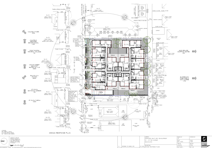
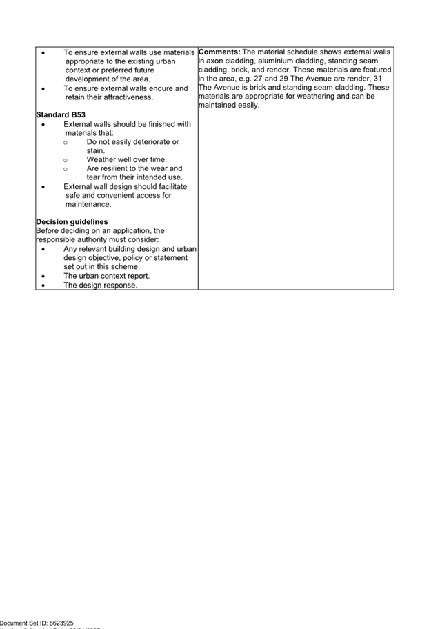
19-25 The Avenue, Balaclava - PDPL/01434/2021/A |
|
|
location/address: |
19 - 25 THE AVENUE BALACLAVA VIC 3183 |
|
Executive Member: |
Brian Tee, General Manager, City Growth and Development |
|
PREPARED BY: |
Grace Brooks, Principal Urban Planner (Floating) |
1. PURPOSE
1.1 To consider and determine a Section 72 Amendment Application (PDPL/01434/2021/A) to amend an existing planning permit which includes:
· Incorporation of an additional Lot within the proposal.
· 6 additional dwellings and car parking spaces
· additional permit trigger for reduction of car parking (one space).
2. EXECUTIVE SUMMARY
|
Ward: |
Balaclava |
|
Trigger
for determination |
More than 16 objections |
|
ApplicATION NO: |
PDPL/01434/2021/A |
|
Applicant: |
Levin Management Pty Ltd |
|
Existing use: |
Residential |
|
Abutting uses: |
Residential |
|
Zoning: |
General Residential Zone Schedule 1 |
|
Overlays: |
Special Building Overlay Schedule 1 |
2.1 Planning Permit PDPL/01434/2021 to “Construct a three storey residential building (across three sites); a front fence exceeding 1.5 metres, comprising 34 dwellings over one basement level” was issued on 30 November 2023 for land at 21-25 The Avenue Balaclava.
2.2 The planning permit is current and there are no endorsed plans.
2.3 The approved development included:
· Demolition of all buildings on site.
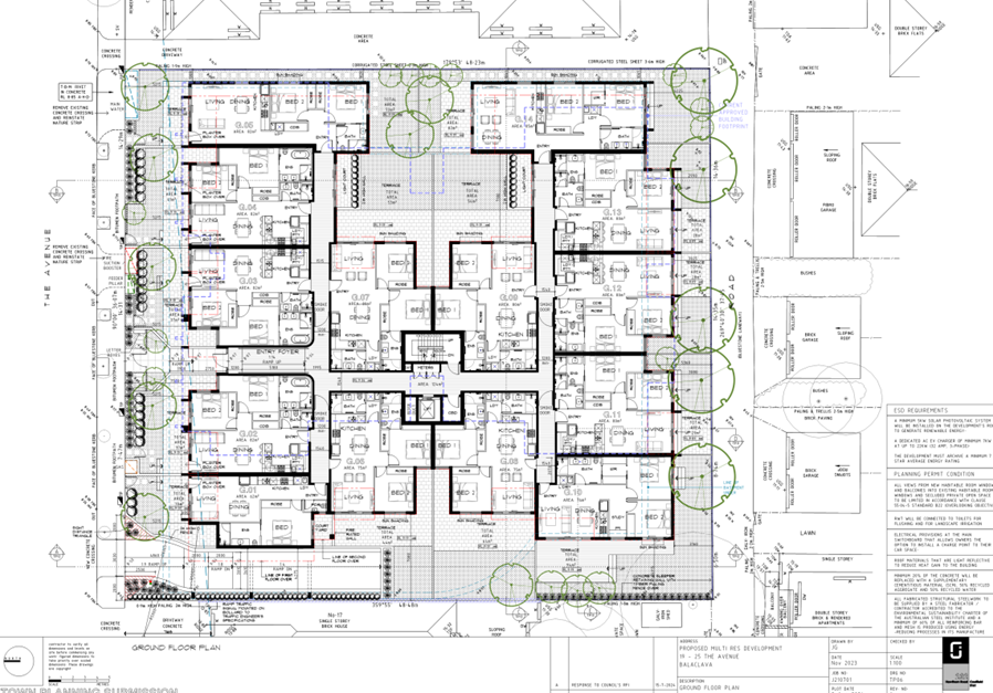
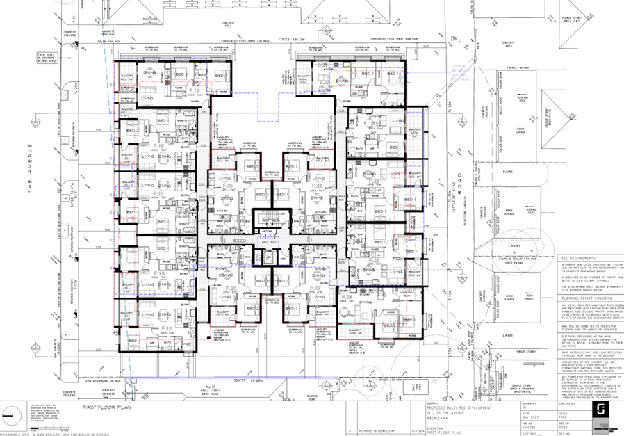
· 34 dwellings in a 3 storey building across 3 properties.
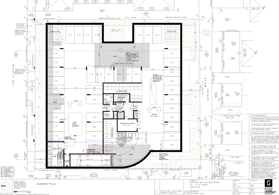
· One basement level containing 34 car parking spaces.
2.4 Council is now considering a Section 72 Amendment application to amend the address, the preamble, permit conditions and plans. The proposal seeks the following changes:
· 40 dwellings in a 3 storey building across 4 properties.
· One basement level containing 40 car parking spaces and a car parking reduction of one car parking space.
2.5 The assessment of this application is confined to the proposed changes to what has already been approved.
2.6 Following notice of the application, Council received 26 objections. The concerns relate to a broad range of issues including:
· Traffic and car parking.
· Visual bulk, and excessive height.
· Noise.
· Overshadowing and loss of sunlight.
· Overlooking and loss of privacy.
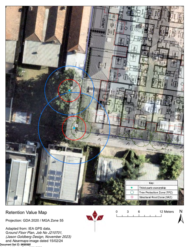
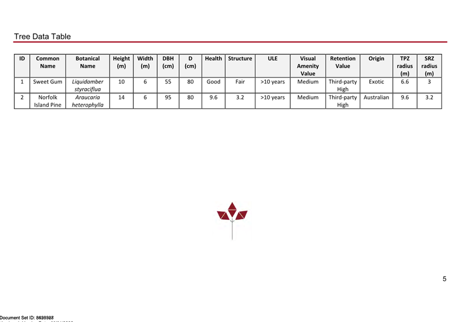
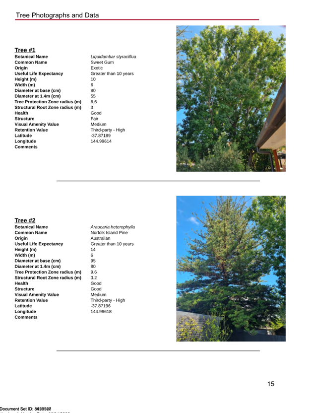
· Protection of the Norfolk Island Pine tree at 17 The Avenue.
· Inaccuracy of information submitted with the application and processes.
2.7 A Consultation Meeting was held on 17 December 2024. The meeting was attended by councillors, the applicant, objectors, and planning officers. The meeting did not result in any formal changes.
2.8 The proposed amendment would maintain the level of strategic support and compliance with applicable zone, overlays, and particular provisions when compared with the approved development.
2.9 The proposed amended development would provide for an appropriate level of streetscape articulation, an acceptable mix of dwelling types, appropriate car parking rates, would maintain the approved level of amenity, and would not result in additional external amenity impacts.
2.10 It is considered that the changes proposed in the amendment application are acceptable, subject to modifications to the conditions of the existing permit. It is recommended that Council issues a Notice of Decision to Amend a Planning Permit.
2.11 Previous Condition 1 requirements that have been complied or no longer considered relevant have been deleted from the recommend conditions (see Section 11.9).
|
3.1 That the Responsible Authority, having caused the application to be advertised and having received and noted the objections, issue a Notice of Decision to Amend a Planning Permit. 3.2 That a Notice of Decision to Amend a Planning Permit be issued with the following changes: 3.3 That the permit address, preamble, and conditions show
changes including deletions as 3.4 That the decision be issued as follows: Amended address:
Amended permit preamble:
Amended conditions: Amended Plans Required 1. Before
the development starts, amended plans to the satisfaction of the Responsible
Authority must be submitted to and approved by the Responsible Authority.
When approved, the plans will be endorsed and will then form part of
the permit. The plans must be drawn to scale with dimensions and an
electronic copy must be provided. The plans must be generally in
accordance with the plans submitted with the application a) b) c) d) e)
f) The
location and cubic metre capacity of storage to g) h) A notation to achieve a minimum 7 – star average energy rating. i) The size and location of the solar photovoltaic system. j) A notation outlining that there are electrical provisions at the main switchboard that allows owners the option to install a charge point to their car space. k) Details of proposed roof materials that are light reflective to reduce heat gain to the building as required in the Sustainability Management Plan required at Condition 13 of this permit. l) A notation stating that a minimum 20% of the concrete will be replaced with a supplementary cementitious material (SCM), 50% recycled aggregate and 50% recycled water. m) A notation stating that all fabricated structural steelwork to be supplied by a steel fabricator / contractor accredited to the environmental Sustainability Charter of the Australian Steel Institute and a minimum of 60% of all reinforcing bar and mesh is produced using energy -reducing processes in its manufacture. n) Any
changes or notation required to accord with the amended Sustainability
Management Plan required pursuant to Condition o) Any
changes to the plans to accord with the amended Water Sensitive Urban Design
Report required pursuant to Condition p) Any
Changes to the plans to accord with the amended Waste Management Plan
required pursuant to Condition q) Any
changes required to comply with the Melbourne Water requirements at Condition
r) Any changes required to accord with the arborist report required at Condition 10 of this permit. s) Any changes required to accord with the revised landscape plan required at Condition 11 of this permit. t) Location of the urban art required by Condition 22 of this permit. u) Notation of the rainwater tank volume and connection details for stormwater reuse on the basement plan. v) An access hatch to the rainwater tank for maintenance purposes on the basement plan. w) Notation that identifies the car parking allocation for each unit. 2 car parking spaces must be allocated to the 3bed dwelling and one 1bed dwelling is to be allocated no car parking space. x) The bottom 1 in 8 grade transition of the ramp with a minimum 2.5m length. y) Minimum 2.2m headroom as per AS2890.1 at the entrance to the basement when the roller door is at the opened position and throughout the basement. z) Ceiling height in waste collection point to enable the 6.4m rear mini loader to lift the bins. aa) Increase the height of the wall between the accessway and bedroom window of G.01 to 1.4m as required by Clause 55.03-1 Standard B15 (Parking Location Objective). bb) The mailbox size and location to comply with the requirements of Clause 55.07-18 Standard B52 (Site Services Objective). cc) Paved areas at the rear of the site, outside of the Tree Protection Zone of Trees 1 and 2 at 17 The Avenue, as being permeable paving to achieve an overall minimum permeable area of 16% to satisfy Clause 55.05-3 Standard B9 (Permeability and Stormwater Management Objective). dd) Changes required by Ironbark Environmental Arboriculture, dated 28 March 2024 and shown on TP06 prepared by Jason Goldberg Design received 14 November 2024 to protect Tree 1 at 17 The Avenue. No Alterations 2. The layout of the site and the size, levels, design and location of buildings and works shown on the endorsed plans must not be modified for any reason without the prior written consent of the Responsible Authority. Satisfactory Continuation and Completion 3. Once the development has started it must be continued and completed to the satisfaction of the Responsible Authority. Ongoing involvement of the Architect 4. The
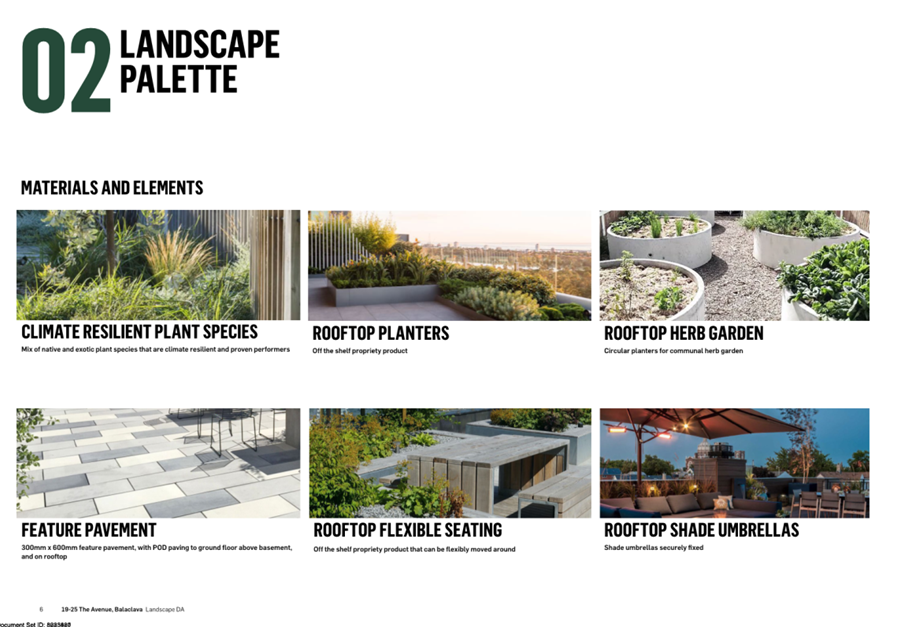
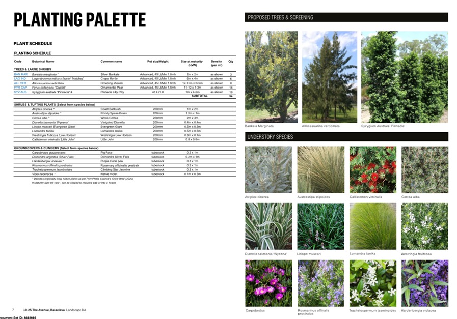
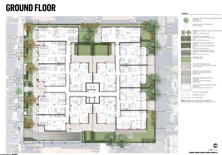
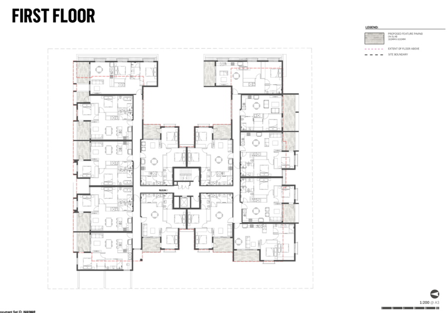
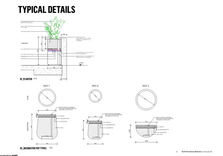
applicant must retain Privacy Screening Must Be Installed 5. Prior to the issue of any Certificate of Occupation for the development allowed by this permit the installation of privacy screens must be undertaken in accordance with the endorsed plans. The privacy screens must be maintained thereafter to the satisfaction of the Responsible Authority. Walls on or Facing the Boundary 6. Prior to the issue of any Certificate of Occupation for the development allowed by this permit all new or extended walls on or facing the boundary of adjoining properties and/or a laneway must be cleaned and finished to a uniform standard to the satisfaction of the Responsible Authority. Unpainted or unrendered masonry walls must have all excess mortar removed from the joints and face and all joints must be tooled or pointed also to the satisfaction of the Responsible Authority. Painted or rendered or bagged walls must be finished to a uniform standard to the satisfaction of the Responsible Authority. No Equipment or Services 7. Any plant, equipment or domestic services visible from the primary street (other than a lane) or public park must be located and visually screened to the satisfaction of the Responsible Authority. Vehicle Crossings 8. Prior to the issue of any Certificate of Occupation for the development allowed by this permit, vehicle crossings must be constructed in accordance with Council’s current Vehicle Crossing Guidelines and standard drawings to the satisfaction of the Responsible Authority. All redundant crossings must be removed and the footpath, nature strip, kerb and road reinstated as necessary at the cost of the applicant/owner and to the satisfaction of the Responsible Authority. Car and Bicycle Parking layout 9. Before the occupation of the development starts, the area(s) set aside for the parking of vehicles and bicycles and access lanes as shown on the endorsed plans must, to the satisfaction of the Responsible Authority, be: a) Constructed; b) Properly formed to such levels that may be used in accordance with the plans; c) Surfaced with an all weather surface or seal coat (as appropriate); d) Drained and maintained; e) Line marked to indicate each car space, bicycle space, loading bay and/or access lane; and f) Clearly marked to show the direction of traffic along access land and driveways. Revised Arboricultural Impact Assessment 10. Simultaneously with the plans submitted under Condition 1, a revised arborist report must be submitted to and approved by the responsible authority. When the arborist report is approved, it will be endorsed and form part of this permit. The arborist report must be generally in accordance with the submitted arborist report (prepared by Ironbark Environmental Arboriculture, dated 28 March 2024) but revised to show: a) Assessment of the proposal and impact on Tree 1 and Tree 2 at 17 The Avenue. Revised Landscape Plan 11. Simultaneously with the plans submitted under Condition 1, a revised landscape plan must be submitted to and approved by the responsible authority. When the landscape plan is approved, it will be endorsed and form part of this permit. The landscape plan must be generally in accordance with the submitted landscape plan (prepared by Urbis, Revision C, dated November 2024) but revised to show: a) Changes required by Ironbark Environmental Arboriculture, dated 28 March 2024 and shown on landscape plan prepared by Urbis received 14 November 2024 to protect Tree 1 at 17 The Avenue. b) A survey plan, including botanical names, of all existing vegetation/trees to be removed or retained. c) Buildings and vegetation, including botanical names, on neighbouring properties within 3m of the boundaries. d) Plant and tree schedule to the satisfaction of the responsible authority. e) Notation indicating proposed plant and tree species in all proposed landscaped areas. f) Details of planters, including sections. g) Sections of the basement and the rooftop to show the relationship with the planters. h) Lighting in common areas. i) Paving materials in the material schedule. j) Irrigation information. k) Ongoing maintenance schedule. Completion and maintenance of Landscaping 12. The landscaping as shown on the endorsed Landscape Plan must be carried out and completed to the satisfaction of the Responsible Authority before the occupation of the development and/or the commencement of the use or at such later date as is approved by the Responsible Authority in writing. The landscaping as shown the endorsed Landscape Plan must be maintained, and any dead, diseased or damaged plant replaced in accordance with the landscaping plan to the satisfaction of the Responsible Authority. Amended Sustainability Management Plan 13. Prior
to the plans being endorsed under condition 1 of this permit, an amended Sustainability
Management Plan (SMP) must be submitted to and be approved by the Responsible
Authority. The SMP must be generally in accordance with the SMP by a) Delete any references to City of Stonnington and replace with City of Port Phillip. b) At Section 1.6 Transport and Section 8 Transport revise ‘Electrical infrastructure for future EV charger to enable each resident to charge cars in the future’ to add ‘to each car space’. c) Revised site permeability and STORM assessment to accurately reflect the plans. Impermeable surfaces and areas above the basement cannot be included in the calculation of permeability. Where alternative ESD initiatives are proposed to those specified in this condition, the Responsible Authority may vary the requirements of this condition at its discretion, subject to the development achieving equivalent (or greater) ESD outcomes. When approved, the Assessment will be endorsed and will then form part of this permit and the project must incorporate the sustainable design measures listed. Incorporation and Maintenance of Sustainable Design Initiatives 14. Prior to the issue of any Certificate of Occupation for development allowed by this permit, the provisions, recommendations and requirements of the endorsed Sustainability Management Plan must be implemented and complied with to the satisfaction of the Responsible Authority. The ESD initiatives of the endorsed Sustainability Management Plan must be fully implemented and maintained throughout the operational life of the development to the satisfaction of the Responsible Authority. Amended Water Sensitive Urban Design Report 15. Prior
to the plans being endorsed under Condition 1 of this permit, an amended
Water Sensitive Urban Design (Stormwater Management) Report must be submitted
to and approved by the Responsible Authority. The report must be generally in
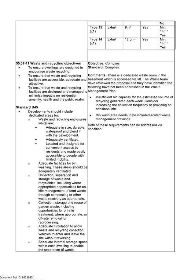
accordance with the SMP by · A full list of maintenance tasks, · The required frequency of each maintenance task (monthly, annually etc.), · Person responsible for each maintenance task. When approved, the Report will be endorsed and will form part of this permit. Incorporation of Water Sensitive Urban Design Measures 16. Prior to the occupation of any dwelling/building approved under this permit, the provisions, recommendations and requirements of the endorsed Water Sensitive Urban Design Report must be implemented and complied with to the satisfaction of the Responsible Authority. General Amenity Provision 17. The use and development must be managed so that the amenity of the area is not detrimentally affected, through the: a) Transport of materials, good or commodities to and from the land b) Appearance of any building, works or materials c) Emission of noise, artificial light, vibration, smell fumes, smoke, vapour, steam, soot, ash, dust, waste water, waste products, grit or oil d) Presence of vermin To the satisfaction of the responsible authority. Dust Control 18. External stockpiles must be covered and maintained to avoid dust nuisance to any residential area to the satisfaction of the responsible authority. Construction Management Water Sensitive Urban Design 19. The developer must ensure that throughout the construction of the building(s) and construction and carrying out of works allowed by this permit: a) No water containing oil, foam, grease, scum or litter will be discharged to the stormwater drainage system from the site; b) All stored wastes are kept in designated areas or covered containers that prevent escape into the stormwater system; c) The amount of mud, dirt, sand, soil, clay or stones deposited by vehicles on the abutting roads is minimised when vehicles are leaving the site. d) No mud, dirt, sand, soil, clay or stones are washed into, or are allowed to enter the stormwater drainage system; e) The site is developed and managed to minimise the risks of stormwater pollution through the contamination of run-off by chemicals, sediments, animal wastes or gross pollutants in accordance with currently accepted best practice. Amended Waste Management Plan 20. Prior
to the plans being endorsed under Condition 1, an amended Waste Management
Plan (WMP) must be submitted to and approved by the Responsible Authority.
The WMP must be generally in accordance with the WMP submitted by One Mile
Grid dated a) b) c) d) e) Increase the collection frequency or provide an additional bin for recycling. f) Bin wash area on the waste management drawings. When approved the WMP will be endorsed and form part of the permit. No Damage to Existing Street Trees 21. The proposed works must not cause any damage to existing street trees. Root pruning of any street tree must be carried out to the satisfaction of the Responsible Authority prior to the construction/reinstatement of the kerb and channel/works. All trees will require a tree protection zone which complies with AS 4970-2009 at all times throughout the demolition and construction phase of the development. A tree protection fence is to be installed around any tree that is likely to be impacted by construction. The fence is to be constructed in a diamond or square position around each tree trunk from 4 panels of a minimum height 1.8m x minimum length 2.1m, interlocking by bolted clamps and concrete pads. No entry to this area is permitted without the consent of the Responsible Authority. Urban Art 22. Prior to the endorsement of plans under Condition 1 of this permit, an urban art plan in accordance with Council’s Urban Art Strategy must be submitted to and approved by the Responsible Authority. The value of the urban art must be at least 0.5% of the total building cost of the development to the satisfaction of the Responsible Authority. Urban art in accordance with the approved Urban Art plan must be installed prior the issue of any Certificate of Occupancy for the development. Melbourne Water Conditions 23. Finished floor levels of the ground floor must be constructed no lower than 9.34 metres to Australian Height Datum (AHD). 24. The basement entrance/ exist must incorporate a flood proof apex and associated bunding constructed no lower than 9.04 metres to AHD. 25. The front fence must be 'open style' (50%) of construction or timber paling to allow for the conveyance of overland flow. 26. Prior to the issue of an Occupancy Permit, a certified survey plan, showing finished floor levels (as constructed) reduced to the Australian Height Datum, must be submitted to Melbourne Water to demonstrate that the floor levels have been constructed in accordance with Melbourne Water requirements. Time for Starting and Completion 27. This permit will expire if one of the following circumstances applies: a) The development is not started within two (2) years of the date of this permit. b) The development is not completed within four (4) years of the date of this permit. The Responsible Authority may extend the periods referred to if a request is made in writing: · before or within 6 months after the permit expiry date, where the use or development allowed by the permit has not yet started; and · within 12 months after the permit expiry date, where the development allowed by the permit has lawfully started before the permit expires. Amendment Table (to be added to the amended permit)
3.5 Authorise the Manager City Development to instruct Council’s Statutory Planners and/or Council’s advocate on any VCAT application for review should one be lodged. |
4. RELEVANT BACKGROUND
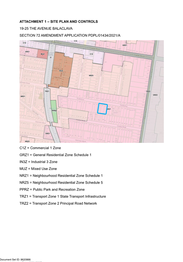
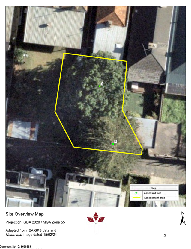
Subject site and surrounds
4.1 The following table sets out the key information in relation to the subject site and the surrounds:
|
|
Description of Site and Surrounds |
|
Existing building and site conditions |
· The site comprises 4 allotments, being 19, 21, 23, 25 The Avenue. The combined frontage to The Avenue is 43.84m, the eastern boundary is 48.23m, the combined rear boundary to roadway R1479 37.45m, and the western boundary is 48.48m. The total area of the site is 2120sqm. · The site is located on the south side of The Avenue between William Street to the west and Hotham Street to the east. The land is generally flat. · Each lot is currently occupied with a single storey dwelling. 23 and 25 each have a crossover and driveway to their eastern boundaries. · None of the lots are affected by a restrictive covenant on the Certificate of Title. |
|
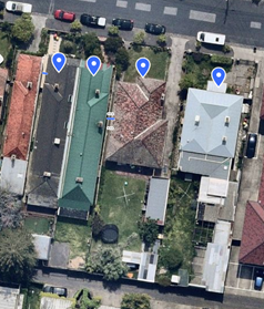
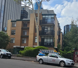
Image of the subject site |
Figure 3: aerial image of the site sourced from NearMaps dated 13 October 2024 |
|
Surrounds/neighbourhood character |
· The site sits within a predominantly residential context with a highly diverse neighbourhood character. The housing stock in The Avenue consists of housing types and styles ranging from single storey Victorian dwellings, mid 1900s apartment block of 2 to 3 storeys, and contemporary medium density residential development. · The site is located approximately 450m from Carlisle Street activity centre and Balaclava train station. · The site has the following interfaces: North · To the north is The Avenue, a 10m-wide single carriageway road of asphalt with bluestone kerb and gutters. On-street car parking is available on both sides of the road and is unrestricted. · Opposite the site is 22 The Avenue, a single storey detached dwelling, 24 and 26 The Avenue, both 2 storey apartment blocks, and 28 The Avenue, a 3 storey apartment block. East · To the east is 27 The Avenue, a double storey apartment block with rendered exterior and pitched tiled roof. The building contains ground and first floor habitable room windows on the western elevation that face the site. South · The site abuts a bluestone laneway, identified as roadway R1479. The laneway has an approximate width of 3.5-4m and is primarily used for the rear vehicle access to properties that front The Avenue and Gourlay Street. West · To the west is 17 The Avenue, a single storey detached dwelling. |
|
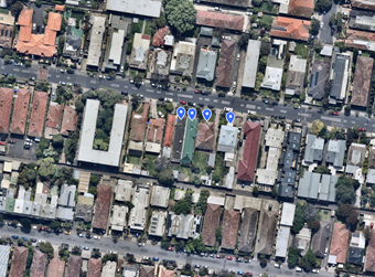
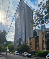
Image of the surrounding area |
Figure 4: aerial image sourced from NearMaps dated 13 October 2024 |
4.2 The following relevant applications have previously been considered for the subject site:
|
Application No. |
Proposal |
Decision |
Date of Decision |
|
PDPL/01434/2021 |
Construct a three storey residential building (across three sites); a front fence exceeding 1.5 metres. Comprising 34 dwellings over one basement level. The following conditions require plans to be submitted for endorsement before the development starts: · Condition 11 – Sustainability Management Plan · Condition 13 – WSUD report · Condition 16 – Waste Management Plan · Condition 18 – Urban Art Condition 10 refers to an endorsed landscape plan. The landscape plan is not endorsed and its endorsement is not captured in a condition. There are no endorsed plans. |
Approved at Planning Committee Meeting |
30 November 2023 |
5. PROPOSAL
5.1 The Section 72 amendment application seeks the following:
· Include 19 The Avenue in the site area. Subsequent change in addressing of the permit from 21-25 The Avenue to 19-25 The Avenue.
· Change the permit preamble as follows:
Construct a three storey
residential building (across three four sites); a front fence
exceeding 1.5 metres, comprising 34 40 dwellings over one
basement level and a reduction in the car parking requirements,
generally in accordance with the endorsed plans and subject to the following
conditions
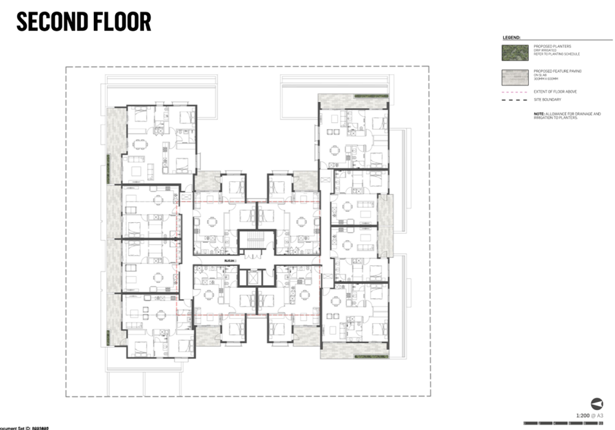
· Increase the number of apartments from 34 to 40.
· Car parking reduction of one space.
· Changes to Conditions 1, 1a), 1d), 1e), 1g) as follows:
1. Before the
development starts, amended plans to the satisfaction of the Responsible
Authority must be submitted to and approved by the Responsible Authority. When
approved, the plans will be endorsed and will then form part of the permit. The
plans must be drawn to scale with dimensions and an electronic copy must be
provided. The plans must be generally in accordance with the plans submitted
with the application (prepared by AWA Architects and Interior Design,
identified as Drawings TP01 through to TP20, Architect and dated as
received on 24 January 2023) but modified to show:
a) All
changes in accordance with the plans ‘discussion plans’ prepared
Jason Goldberg Design Dated X by AWA Architects and Interior Design
noted as Basement plan, Ground, First Floor Plan noted as plotdate 12 July
2023, Second Floor Plan and Roof Plan noted as plot date 10 July2023, North and
South Elevation Plan noted as plot date 12 July 2023, East and West Elevation
Plan noted as plot date 11 July 2011 and Section Plan noted as plot date 10
July 2023 but modified to show the changes required by Condition 1b to q below.
d) Changes
to the built form to ensure compliance with Clause 55.04-5 Standard B21
(Overshadowing Open Space Objective) as it affects the secluded private open
space of No. 19 The Avenue.
e) The
materials schedule amended to change;
· The
dark Grey Colour Render (noted as R2) along the ground and first floor front
elevation to brick in a similar colour. The brick finish to wrap around the
side elevations for a depth of 1 apartment
· The
light render wall (note as R1) on the west elevation above the basement entry.
· The
central section of the entry shown as Dark Grey Colour Render (noted as R2)
changed to Axon Cladding Dark Colour (noted as Ax dark colour).
g) Additional
highlight window provided in Bedrooms 2 of apartments G1 2, 2 3, 9
11 12 and 10 13 to provide improved air circulation in accordance with
Clause 55.07-15 Standard D49 (Natural Ventilation Objective)
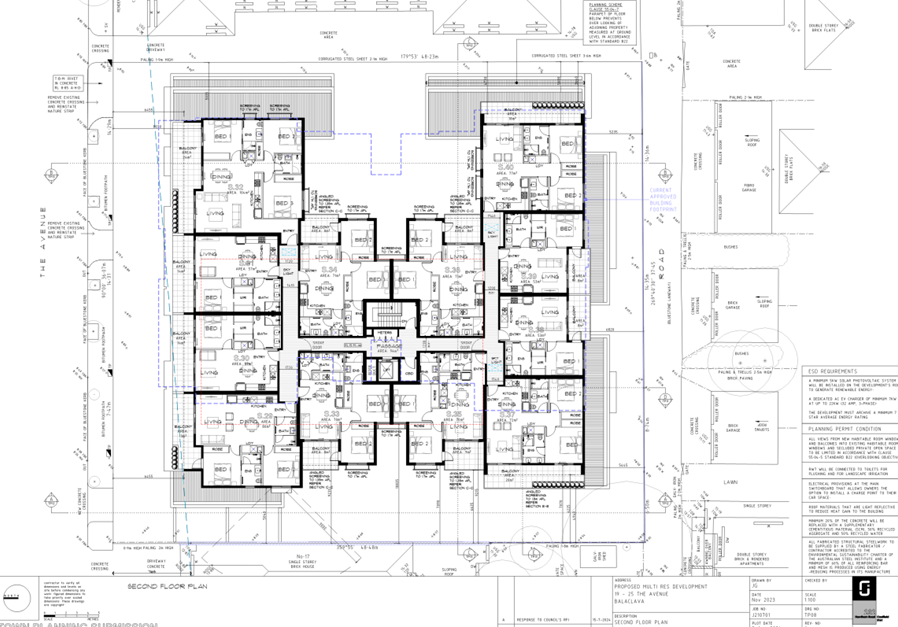
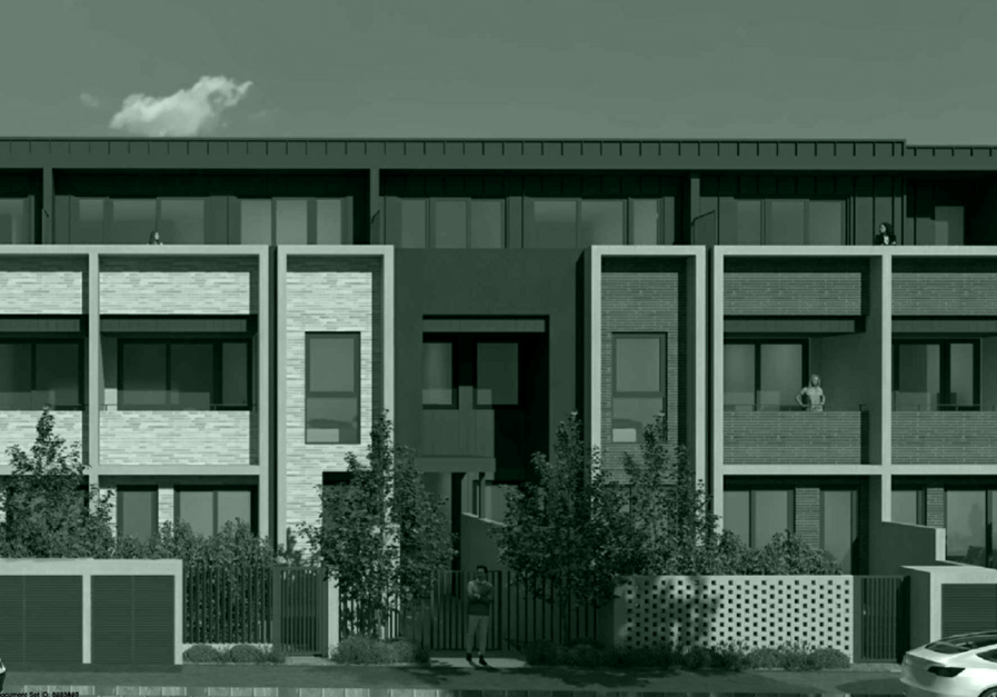
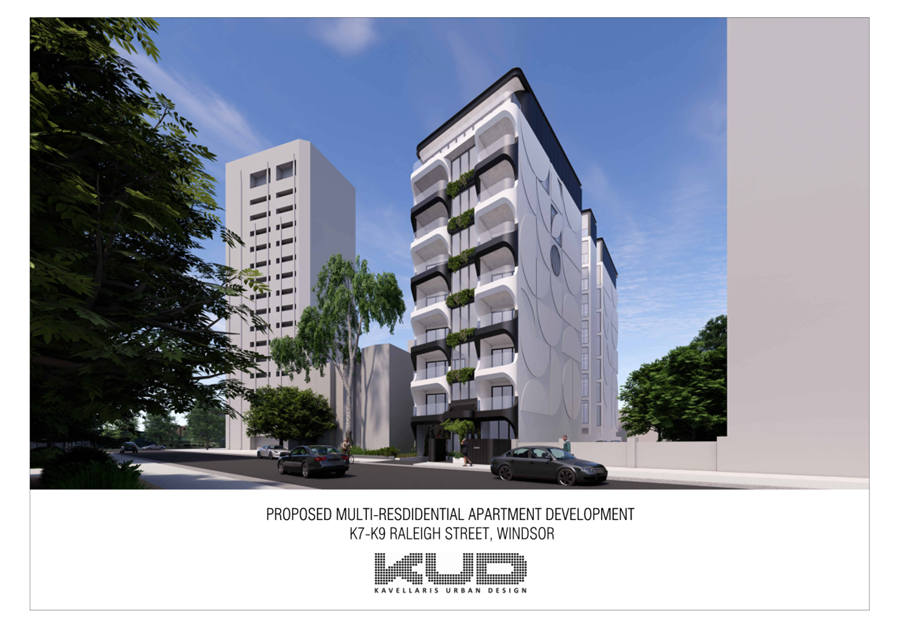
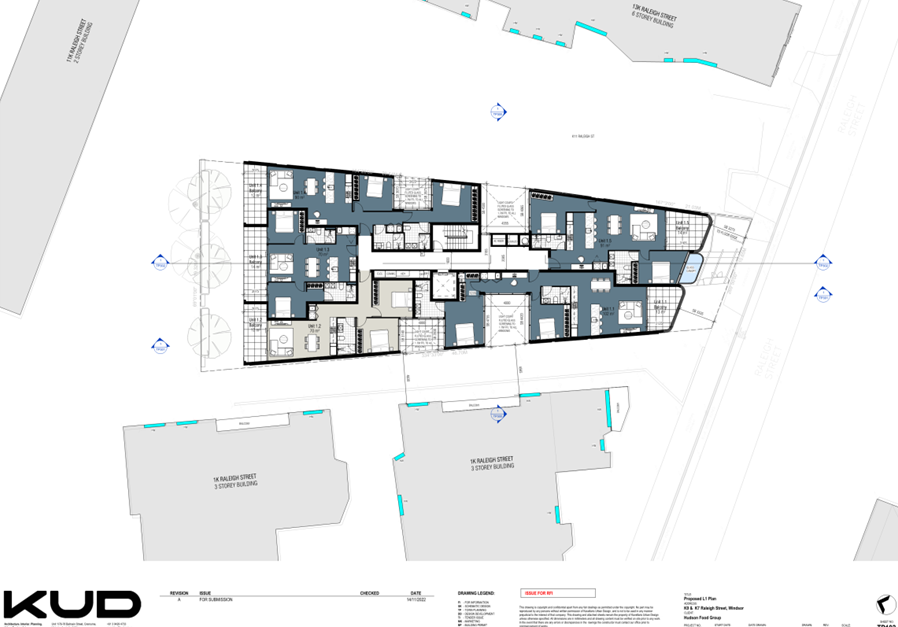
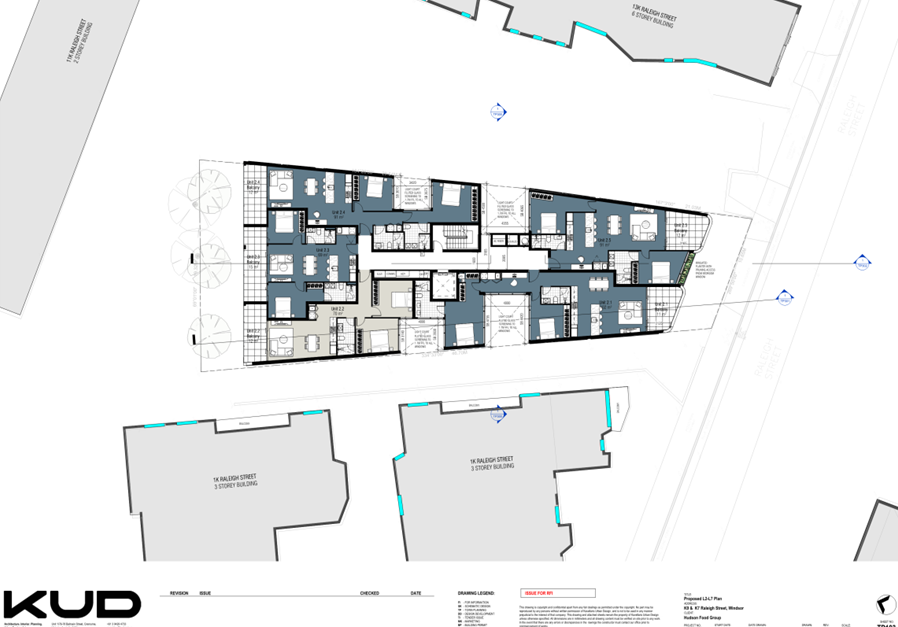
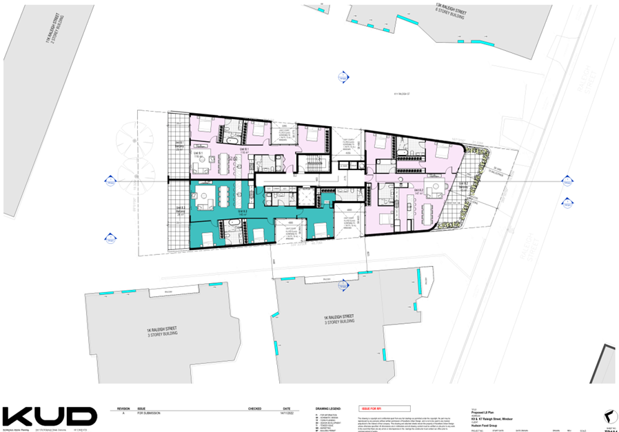
5.2 The following are images that show a comparison of the “as approved” development and the proposed amendment.
Figure 1: applicant’s 3D perspective of the proposal considered in the discussion plans for the original planning permit application, prepared by AWA Architects and Interior Design
Figure 2: applicant’s 3D perspective of the proposal subject of this amendment prepared by Jason Goldberg Design
5.3 The below table compares the key elements of the proposal with the approved development:
|
|
Approved |
Proposed |
||||||||||||
|
Properties |
21, 23, 25 The Avenue |
19, 21, 23, 25 The Avenue |
||||||||||||
|
Site area |
1763sqm |
2120sqm |
||||||||||||
|
Preamble |
Construct a three storey residential building (across three sites) a front fence exceeding 1.5 metres, comprising 34 dwellings over one basement level |
Construction of a three storey apartment building containing dwellings over one basement level of car parking and a front fence exceeding 1.5 metres in height on a lot within the General Residential Zone (GRZ1) and affected by the Special Building Overlay (SBO1) and a reduction in car parking requirements, generally in accordance with the endorsed plans and subject to the following conditions: The applicant has since sought to amend the permit preamble to accord with Myers format which would present as follows:
|
||||||||||||
|
Demolition |
Yes |
Yes |
||||||||||||
|
Height |
RL19.74m (excluding lift overrun and plant screen) / 10.8m |
RL19.89m (excluding lift lobby and plant screen) / 10.55m from Melbourne Water flood level RL9.34m |
||||||||||||
|
Garden area |
35% |
35.4% |
||||||||||||
|
Dwelling breakdown |
Dwelling type |
Number |
Number |
Difference |
||||||||||
|
1 bedroom |
9 |
8 |
-1 |
|||||||||||
|
2 bedroom |
25 |
31 |
+6 |
|||||||||||
|
3 bedroom |
None |
1 |
+1 |
|||||||||||
|
Total |
34 |
40 |
+6 |
|||||||||||
|
Communal areas |
None |
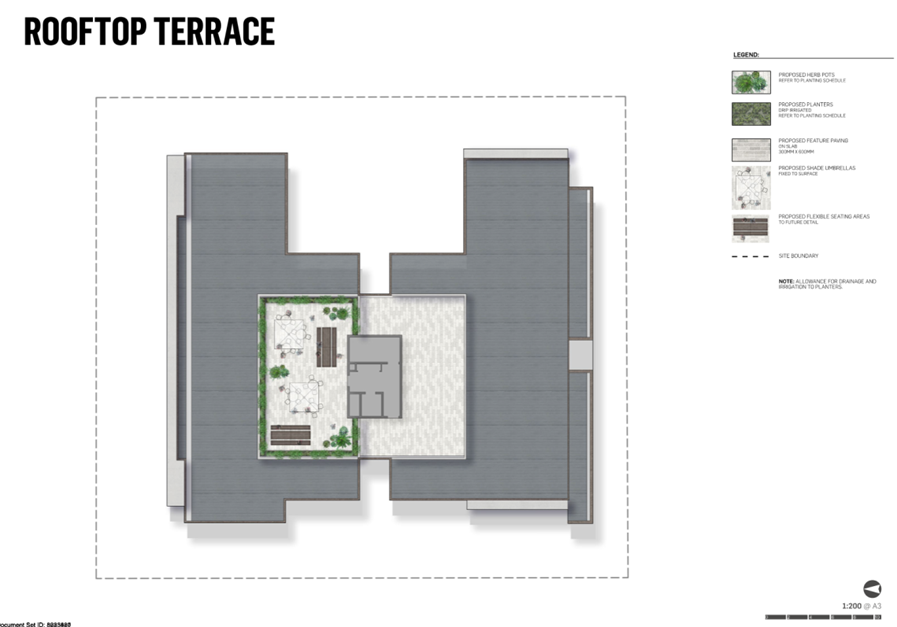
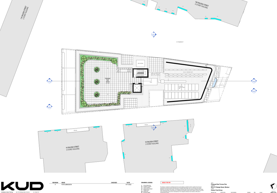
Rooftop terrace 125sqm |
||||||||||||
|
Setbacks |
Ground Floor |
|
Ground Floor |
Difference |
||||||||||
|
North (front) |
4.7m (to wall) |
5.2m (to wall) |
+0.5m |
|||||||||||
|
East (side) |
1.1m |
1m |
-0.1m |
|||||||||||
|
South (rear) |
3m (to wall) |
3m (to wall) |
No change |
|||||||||||
|
West (side) |
4.3m |
4.3m |
No change |
|||||||||||
|
First floor |
|
First floor |
Difference |
|||||||||||
|
North |
4.7m (to wall) |
5.2m (to wall) |
+0.5m
|
|||||||||||
|
East |
1.95m |
2.2m |
+0.25m |
|||||||||||
|
South |
3m (to wall) |
3m (to wall) |
No change |
|||||||||||
|
West |
3.2m |
3.2m |
No change |
|||||||||||
|
Second floor |
|
Second floor |
Difference |
|||||||||||
|
North |
6.9m (to wall) |
7.3m (to wall) |
+0.4m |
|||||||||||
|
East |
5m |
5m (to wall) |
No change |
|||||||||||
|
South |
5.3m |
5.2m |
-0.1m |
|||||||||||
|
West |
5m |
5m |
No change |
|||||||||||
|
Crossovers |
Remove crossovers in front of 23 and 25 The Avenue. New crossover in front of 21 The Avenue. |
Remove crossovers in front of 23 and 25 The Avenue. New crossover in front of 19 The Avenue. |
||||||||||||
|
Basement |
1 level |
1 level |
||||||||||||
|
Car parking |
34 spaces |
40 spaces Reduction of 1 space |
||||||||||||
|
Bicycle parking |
10 spaces |
12 spaces |
||||||||||||
|
Front fence |
1.6-1.885m in height. Includes gas, fire booster and water main cupboards. Mix of materials – brick, pickets, and pickets on plinths. |
1.6-1.885m in height. Includes gas, fire booster and water main cupboards. Mix of materials – brick, pickets, and pickets on plinths. Extent of brick wall has increased. |
||||||||||||
|
Rainwater tank |
20,000 litre tank below basement level. |
20,000 litre tank below basement level. |
||||||||||||
5.4 Since the issue of the original permit, Myers v Southern Grampians Shire Council [2023] VSC 658 has established a protocol for planning permit descriptions. For permits that precede that decision subject to Section 72 amendments, Council seeks to update the preamble with the permit triggers in addition to the descriptive preamble upon approval. The applicant has agreed that if this application is supported, the preamble can be updated to include permit triggers in line with that decision. Accordingly, the following table is to be added to the preamble:
|
Planning Scheme Clause No.: |
Description of what is allowed |
|
Clause 32.08-7 |
Construct two or more dwellings on a lot in a General Residential Zone. |
|
Clause 32.08-7 |
Construct a front fence within 3m of a street in a General Residential Zone. |
|
Clause 44.05-2 |
Construct a building or construct or carry out works in a Special Building Overlay. |
|
Clause 52.06-3 |
Reduce (including reduce to zero) the number of car parking spaces required under Table 1 of Clause 52.06-5. |
6. Permit Triggers
6.1 Section 73(1) of the Planning and Environment Act 1987 states that Sections 47 to 62 apply to an application to amend a permit as if the application were an application for a permit.
6.2 Therefore, the amendments to the permit and plans are to be assessed against the relevant planning controls affecting the proposal.
6.3 Only the changes to the approved proposal are considered as part of this application for amendment.
6.4 The following controls/permit triggers are considerations for this permit:
|
Zone or Overlay |
Why is a permit required? |
New permit trigger? |
|
Clause 32.08 General Residential Zone Schedule 1 (GRZ1) |
Clause 32.08-6 states that a permit is required to: · Construct two or more dwellings on a lot. · Construct a front fence within 3m of a street if: o The fence is associated with two or more dwellings on a lot or a residential building; and o The fence exceeds the maximum height specified in Clause 55.06-2 (i.e. 1.5m). A development must meet the requirements of Clause 55. A planning permit is required under this clause for the above. |
No |
|
Clause 44.05 Special Building Overlay Schedule 1 (SBO1) |
Clause 44.05-2 states that a permit is required to: · Construct a building or construct or carry out works. A planning permit is required under this clause. Exemption from notice and review An application under this overlay is exempt from the notice requirements of Section 52(1)(a), (b), and (d), the decision requirements of Section 64(1), (2) and (3) and the review rights of Section 82(1) of the Act. |
No |
|
Clause 52.06 Car Parking |
Pursuant to Clause 52.06-3, a planning permit is required to reduce (including reduce to zero) the number of car parking spaces required under Table 1 of Clause 52.06-5 or in a schedule to the Parking Overlay. The proposal general the requirement of 41 car parking spaces and provides for 40 car parking spaces. A planning permit is required under this clause. |
Yes |
|
Clause 52.34 Bicycle Facilities |
Clause 52.34-2 states that a permit may be granted to: · Vary, reduce or waive any requirement of Clause 52.34-5 and Clause 52.34-6. Clause 52.34-5 sets out the statutory rate for bicycle spaces. Pursuant to Clause 52.34-5, no bicycle spaces are required for the development as it does not contain 4 or more storeys. No planning permit is required under this clause. |
No |
7. PLANNING SCHEME PROVISIONS
7.1 The following provisions of the Metropolitan Planning Strategy are relevance to this application:
Clause 02 MPS
02.01 Context
02.02 Vision
02.03 Strategic Directions
02.04 Strategic Framework Plans
7.2 The following provisions of the Planning Policy Framework are relevance to this application:
Clause 11 Settlement
11.01 Victoria
11.01-1S Settlement
11.01-1R Settlement – Metropolitan Melbourne
11.02 Managing Growth
11.03 Planning for Places
Clause 15 Built Environment and Heritage
15.01 Urban Design
15.01-1S Urban Design
15.01-1R Urban Design – Metropolitan Melbourne
15.01-1L-02 Urban Design
15.01-2S Building Design
15.01-2L-01 Building Design
15.01-2L-02 Environmentally Sustainable Development
15.01-5S Neighbourhood Character
15.01-5L Neighbourhood Character
Clause 16 Housing
16.01 Residential Development
16.01-1S Housing Supply
16.1-1R Housing Supply – Metropolitan Melbourne
16.01-1L-01 Housing Diversity
16.01-1L-02 Location of Residential Development
Clause 18 Transport
18.02 Movement Networks
18.02-4L-01 Car Parking
Clause 19 Infrastructure
19.03-3S Integrated Water Management
19.03-3L Stormwater Management (Water Sensitive Urban Design)
7.3 The following Particular Provisions are relevant to this application:
Clause 52 Provisions that Require, Enable or Exempt a Permit
52.06 Car Parking
Clause 53 General Requirements and General Performance Standards
53.03 Residential Reticulated Gas Service Connection
Clause 55 Two or More Dwellings on a Lot and Residential Buildings
7.4 The following General Provisions are relevant to this application:
Clause 62 General Exemptions
62.03 Buildings and Works
62.05 Demolition
Clause 65 Decision Guidelines
65.01 Approval of an Application or Plan
7.5 The following Operational Provisions are relevant to this application:
Clause 71 Operation of this Planning Scheme
71.01 Operation of the Municipal Planning Strategy
71.02 Operation of the Planning Policy Framework
71.03 Operation of Zones
71.04 Operation of Overlays
71.05 Operation of Particular Provisions
7.6 There are no planning scheme amendments relevant to this application.
8. REFERRALS
Internal referrals
8.1 The application was referred to the following areas of Council for comment. The comments are discussed in detail in Section 9.
|
Department |
Referral Comments (summarised) |
Assessing Officer Comments |
|
Arborist |
After notice, the applicant submitted an arborist report and revised ground floor plan on the 2 trees in the rear garden of 17 The Avenue. This report recommended: · Alter the design of the proposed concrete sleeper retaining wall to avoid an SRZ encroachment on Tree 2 (Norfolk Island Pine). · Utilise tree-sensitive design methods that will reduce the impact to the TPZ of Tree 1 (Sweet Gum) such as using screw piles and stumps. · Once the final design has been confirmed, commission arboricultural impact assessment based on the new proposal. Council’s arborist has reviewed the arborist report and ground floor plan and advises that: · Deletion of the retaining wall along the shared boundary will significantly minimise the expected loss of root mass. · The retaining wall along the south boundary, which ends ~3.5m from the boundary, between the subject site and the blue stone laneway has a potential to cause root damage. This potential is relatively low as there would reasonably be little root mass transitioning from the subject sites soil volume into the soil under the blue stone lane due to significant grade change at the boundary. |
Council’s arborist has no further concerns with the proposal with respect to tree impacts, subject to the changes recommended in the arborist report and revised plans being conditioned and approved refer to recommended conditions 1r), cc), dd), 10. |
|
Development Engineer |
No objection, no conditions. |
Noted. |
|
Landscape |
· Concern that there is deficient space for letterboxes. · Concern regarding proposed plant and tree palette as some areas of planting are in heavy shade. Allocasuarina verticillate prefers full sun but is proposed to be planted in an area of heavy shade. · Insufficient information regarding ongoing plant maintenance including irrigation has been provided. · Insufficient information regarding lighting has been provided. · Insufficient information regarding paving materials. · Request that fences including utility enclosures on the front boundary are reduced to a maximum of 1.5m. · Request that a permanent shade structure is added to the rooftop terrace. · Request that planting on the first and second floor balconies is reinstated. · Request condition that requires any plants that die within the first year to be replaced with an alternative species. |
Most of the landscape requirements can be addressed via conditions, including a condition for a revised landscape plan. Based on Australia Post fact sheets, a letter box should have the minimum internal dimensions of 33cm deep x 23cm wide x 16cm high and have apertures 60-160cm from the ground. If the proposed letterbox structure is 1m wide, 41 letterboxes boxes (including the body corporate) the letterbox nest would be 4 boxes wide, 10 boxes high (160cm). This does not accommodate for a plinth at the base. It is likely that the letterbox nest will need to increase in size or be split into 2 nests to accommodate the Australia Post requirements. There is sufficient area at the entry to accommodate this. a condition will recommend that the mailbox be revised to comply with the requirements of Standard B52. The height of the fence is the same as what has been previously approved. It is outside of the scope of Section 72 to reduce the fence now. There is no requirement for shade structures to be provided for communal areas. No condition is required in this regard. The approved plans show no planters on balconies on the first floor and 4 planters on balconies on the second floor. The current plans show no change to planters on balconies. |
|
Sustainability |
No objection subject to conditions. · Section 2.2 of the Sustainability Management Plan refers to City of Stonnington (along with CoPP) and should be corrected to refer to CoPP only. · Sustainability Management Plan at section 1.6 Transport notes ‘Electrical infrastructure for future EV charger to enable each resident to charge cars in the future’ but should be amended to include ‘to each car space’ to be clear. Section 8 Transport of the Sustainability Management Plan should also be amended to include ‘to each car space’ for consistency. Basement Plan notes ‘to each car space’ which is acceptable. · Rainwater tank maintenance manual is empty and will require completion with all required info, as per permit condition 13. · Rainwater tank volume and connection details for stormwater reuse shown basement plan and should also include notation as to access hatch for maintenance purposes. · Ensure bin room layout, number and type of bins in Waste Management Plan is reflected on basement plan; bins in Waste Management Plan are located on basement plans area titled ‘HW’? · Landscape plan generally specifies natives which are appropriate. |
Conditions have been included in the recommendation to address the outstanding matters raised by Councils sustainability advisors. Changes as per recommended conditions, 1 (Amended plans) 13 (updated) SMP and 15 (updated WSUD) require changes to the Sustainability Management Plan, WSUD response and development plans. |
|
Traffic |
· The waiver of one car space can be supported. Considering the public transport availability in the area, the waiver should be assigned to one bedroom component of the development. · A car parking management plan will need to be submitted that shows the allocation of onsite parking to each unit to the satisfaction of the Council. · The plans are to be revised to show the bottom 1 in 8 grade transition of the ramp with a minimum 2.5m length due to the 1 in 4 main grade. · The plans are to be revised to show a minimum 2.2.m headroom as per AS2890.1 at the entrance to the basement (when the roller door is at opened position) and throughout basement. · The plans are to be revised to show adequate ceiling height at the waste collection point to enable the 6.4m rear mini loader to lift the type of bins. · A condition is required stating that all redundant vehicle crossings are to be removed to the satisfaction of the Council. |
Conditions have been added to recommendation to address these requirements (refer to recommended conditions 1w, x, y, and z). Condition 8 of the existing permit also refers to the removal of redundant vehicle crossings. |
|
Waste |
The following matters have not been addressed in the submitted Waste Management Plan: · Insufficient bin capacity for the estimated volume of recycling generated each week. Consider increasing the collection frequency or providing an additional bin. · Bin wash area needs to be included scaled waste management drawings. |
These concerns can be addressed via conditions (refer to recommended Condition 20). |
External referrals
8.2 The application incorporates referral requirement from the following statutory authorities:
|
Referral Authority |
Response |
Assessing officer response |
|
Melbourne Water |
No objection. The conditions from Melbourne Water letter to Council dated 23 January 2023 for PDPL/01434/2021 are still applicable. Advice from 23 January 2023 was that Melbourne Water does not object to the proposal subject to the following conditions: 1. Finished floor levels of the ground floor must be constructed no lower than 9.34 metres to Australian Height Datum (AHD). 2. The basement entrance/exist must incorporate a flood proof apex and associated bunding constructed no lower than 9.04 metres to AHD. 3. The front fence must be ‘open style’ (50%) of construction or timber paling to allow for the conveyance of overland flow. 4. Prior to the issue of an Occupancy Permit, a certified survey plan, showing finished floor levels (as constructed) reduced to the Australian Height Datum, must be submitted to Melbourne Water to demonstrate that the floor levels have been con structed in accordance with Melbourne Water’s requirements. |
Melbourne Water’s recommended conditions from 23 January 2023 have been included on the existing permit as Conditions 19-22 and will remain as per the latest referral response. |
9. PUBLIC NOTIFICATION/OBJECTIONS
9.1 The proposal may result in material detriment therefore Council gave notice of the application by ordinary mail to the owners and occupiers of surrounding properties and directed that the applicant give notice of the proposal by posting 2 notices on the site for a 14 day period, in accordance with Section 52 of the Planning and Environment Act 1987.
9.2 The application has received 26 objections, including 3 from the same property. The key concerns raised are summarised below:
|
Objection (summarised) |
Assessing officer response |
|
Traffic and Transport |
|
|
· Increased traffic. · Associated impacts on safety for residents, pedestrians, cyclists, nearby childcare centre. · Proposed car parking reduction is inappropriate. · Car parking rate is inaccurate. It is noted that there are multiple objections that refer to an additional 80 vehicles (approximately 1 per bedroom or 2 per dwelling). · Single lane accessway to the basement will result in queuing in The Avenue. |
It is acknowledged that the proposal would lead to increased traffic movements to and from the site. However, there is not anticipated to be an adverse safety impact given the proposal design. The Avenue is a local road. The car parking reduction has been assessed as appropriate in this report (refer to section 11.6). The statutory car parking rate in the Planning Scheme has been referred to in this submission. Council cannot require a car parking rate beyond this rate noting there is policy that discourages this. The traffic report refers to the ramp being signalised to manage traffic flow. The signalisation prioritises traffic entering from The Avenue to reduce potential queueing. Neither the traffic report nor Council’s Traffic department have raised concerns of queueing. |
|
Request creation of allocated car parking for residents of The Avenue before the commencement of construction. |
Car parking restrictions can be requested by residents and can be implemented. This is a separate process from the current planning application process. It is noted these measures have not been recommended by Council’s Traffic Engineers in response to this application. |
|
There are inconsistencies with the number of bicycle spaces required. How many are required? |
No bicycle spaces are required by the Planning Scheme to be provided on site. The provision of 12 spaces on site is supported. |
|
Procedural |
|
|
Inclusion of 19 The Avenue in the development site. |
There is no restriction on including additional properties into development sites. |
|
Is a new permit required? |
Section 72 amendment is the appropriate pathway for this application. The assessment of this application is the same as a regular planning permit. |
|
The significant changes proposed warrant a more thorough community consultation process. Local residents and stakeholders should have the opportunity to voice their concerns regarding the increased density, potential parking shortages, and the impact on local services and infrastructure. The council should ensure that the community's views are adequately considered before any amendments are approved. |
The application is being treated the same as all applications – notice of the proposal has been given by mail and signage on the land and anyone has the opportunity to object. Due to the number of objections received, the proposal must be determined by the councillors at a Planning Committee Meeting. |
|
Size and scale / built form |
|
|
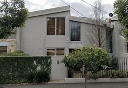
Precedent for large developments in the area. Area is a low density residential area and the proposal conflicts with character and the zone. |
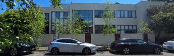
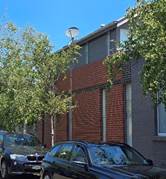
Each application is assessed on its own merit against the controls that apply at the time. The area is not considered low density – this is reflected in the General Residential Zone that applies. Of the 47 properties with a The Avenue address, 24 are apartment buildings.
Figure 5: apartment buildings in The Avenue As described in Section 11 in this report, the proposal is considered consistent with the character and the zone. |
|
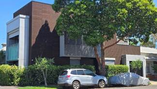
· Adverse visual bulk. · Increase in dwellings is an overdevelopment of the site. · Proposal is inconsistent with neighbourhood character. · Excessive height.
|
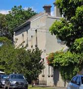
· Visual bulk and character are assessed below in this report at Section 11. · The number of dwellings proposed on any allotment should not be used as the sole indicator as to whether a proposal is an overdevelopment or not. The Planning Scheme does not provide a metric that restricts the number of dwellings provided on a lot or a site, instead providing other metrics that can be used to assess whether a proposal is an overdevelopment, such as garden area, site coverage, building height. These metrics are considered throughout this report. · There are several 3 storey buildings in The Avenue:
Figure 6: 3 storey buildings in The Avenue · That there are several other 3 storey buildings in The Avenue, as well as the broader area, and that the same building height and number of storeys has been previously approved in this permit indicates that these parts of the proposal are compatible with neighbourhood character. · The proposal complies with the height requirements for this area. |
|
How far from the boundary of 17 The Avenue will the boundary fence be erected? |
Boundary fences are constructed on shared boundaries. |
|
Amenity |
|
|
Adverse noise impact from communal rooftop terrace, idling vehicles, security gate, bin storage, additional people entering the building, residential balconies. |
Noise caused by people entering an apartment building and using private balconies are considered domestic. Domestic noise is expected and acceptable in a residential area. |
|
Overshadowing and loss of sunlight |
Overshadowing and loss of solar access is assessed below in this report at Section 11. |
|
Privacy |
Overlooking is assessed below in this report at Section 11. |
|
Vegetation |
|
|
Impact on tree in 17 The Avenue. |
As discussed above in this report at Section 9.1 Internal Referrals, an arborist report has been provided regarding Tree #1, a sweet gum, and Tree #2, a Norfolk Island Pine at 17 The Avenue. This report makes recommendations which the applicant has provided on a revised plan and requested be conditioned. This report has been reviewed by Council’s arborist who does not object to the recommendations therein. |
|
Impact on local green spaces, air quality, waste management. |
Acknowledging construction sites can impact air quality, this is temporary. A condition is recommended regarding dust control. The application includes a Waste Management Plan which has been assessed and found acceptable, subject to conditions. The subject site does not adjoin a green space. |
|
Construction |
|
|
Impacts on roads, footpaths, water runoff, locals during the construction period. |
Acknowledging that construction sites can cause disruption to roads, this is temporary. |
|
· Request restricting the number of days of construction to 5, with no construction allowed before 9am and after 4pm. · Request requirement for only modern, quiet, green construction vehicles be used during construction period. |
Councils Community Amenity Local Law 2023 states without a permit, construction hours are 7am to 6pm Monday to Friday and 9am to 5pm Saturday. Further restriction on construction hours is not possible. Restriction on types of vehicles used on site is not possible. These are not matters for consideration under Section 60 of the Planning and Environment Act 1987. |
|
Potential subsistence of 17 The Avenue due to the basement. |
This is a matter that is dealt with under the Building Regulations, not the Planning and Environment Act 1987. The responsibility of the safety of the build falls to the building surveyor who may require protection works and insurance. Additionally, the builder should carry out a dilapidation report for public liability purposes. |
|
Flooding |
|
|
Additional hard surfaces may impact on flood risk and drainage problems. |
A small portion of the front of the site (all 4 properties) is subject to the Special Building Overlay:
Figure 7: the site subject to the Special Building Overlay, sourced from VicPlan Melbourne Water is the authority for the area covered by the Special Building Overlay. Their commentary is provided above in this report at Section 9.2 External Referrals. To accommodate for increased impervious surfaces at the site, a large rainwater tank is proposed to be used for detention. |
|
Where is the 20,000L rainwater tank proposed to be located? What happens if this tank overflows onto 17 The Avenue? |
The rainwater tank is proposed to be located below the basement floor level. Should this tank fail, this would be a civil matter. |
|
Other |
|
|
References to incorrect council. Inconsistent numbers of bicycles provided on site. |
The Sustainability Management Plan refers to Stonnington Council on pages 5, 9, 10. The Sustainability Management Plan refers to 12 bikes on pages 6 and 18, and 14 bikes on page 18. The BESS and plans refer to 12 bikes. A condition will require that the Sustainability Management Plan is updated to be consistent throughout. |
|
Who is Levin Management Pty Ltd and where are they located? |
This is not a matter for consideration under Section 60 of the Planning and Environment Act 1987. |
|
Property devaluation |
This is not a matter for consideration under Section 60 of the Planning and Environment Act 1987. |
|
Strain on local infrastructure due to increase numbers of residents. |
Infrastructure requirements are considered by both various council departments, such as local roads and waste services, and by the State government. The City of Port Phillip Housing Strategy states that the draft housing target by the Victorian Government is 56,000 new homes by 2051. This target will guide both state and local government policies to provide for sufficient infrastructure to meet future needs. |
9.3 A consultation meeting was held on 17 December 2024. The meeting was attended by Ward Councillors, applicants, objectors, and Planning Officers. The meeting did not result in any changes to the proposal.
9.4 The objectors do not raise any matters of significant social effect under Section 60 (1B) of the Planning and Environment Act 1987.
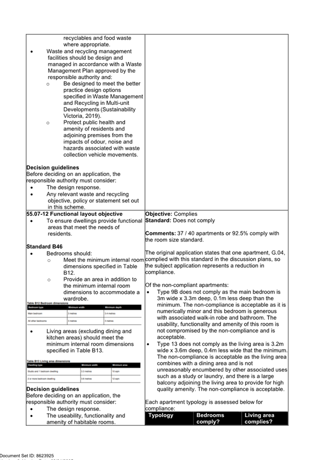
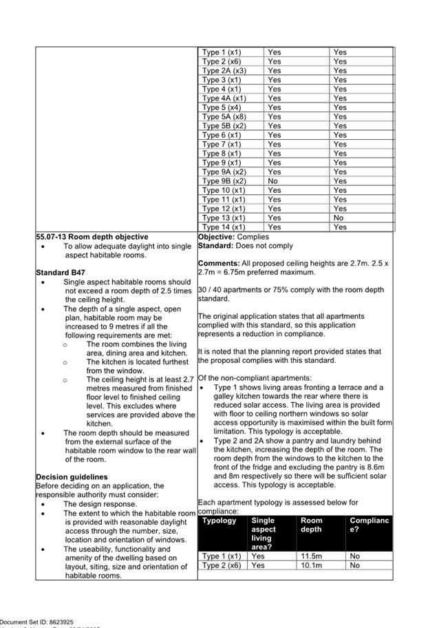
10. OFFICER’S ASSESSMENT
10.1 This amendment seeks to make several changes to the approved permit and previously considered plans. As this is an application to amend the existing planning permit, only the proposed changes can be assessed.
10.2 The key issues that require assessment are considered under the following headings:
· Would the amendment proposal remain consistent with the planning policy framework?
· Does the design respond appropriately to its context?
· Is the building height and number of storeys compliant?
· Is the proposed car parking reduction acceptable?
· Would there be any unreasonable off-site amenity impacts?
· Would there be any unreasonable on-site amenity impacts?
· Are the current conditions of the planning permit appropriate or are amendments required?
Would the amendment proposal remain consistent with the planning policy framework?
10.3 The development of 40 apartments would remain consistent with the planning policy framework.
10.4 The location of the development is considered appropriate from a strategic context, including background document Plan Melbourne 2017-2025 as the site is approximately 7 minutes/450m from Carlisle Street containing commercial and retail premises and Balaclava train station, as well as proximate to a bicycle path network.
10.5 The previous Housing Strategy is identified as a background document in the schedule to Clause 72.08. The strategy refers to the lack of diversity in housing with 66.8% of dwellings containing 2 or less bedrooms. The proposal includes one dwelling with 3 bedroom which is consistent with the strategy.
10.6 Clause 11.03-1S Activity Centres also encourages increased development density of various types, including commercial, retail, and residential, in activity centres in accessible locations.
10.7 Clauses 16.01-1S Housing Supply and 16.01-1L-01 Housing Diversity seek to provide for well-located, integrated, and diverse housing that meets community needs. Development with a mix of dwelling sizes that is located in established urban areas and that are well located in relation to jobs, services, and public transport is sought. The proposal includes 1, 2, and 3 bedroom dwellings in a well serviced area.
10.8 Clause 16.01-1L-02 Location of Residential Development seeks to direct housing growth to designated locations that have the greatest capacity for change and that offer highest accessibility to public transport, shops, and social infrastructure while maintaining neighbourhood character and amenity values of established residential areas that have limited potential for housing growth. The site is an established residential area that has been identified with capacity for some growth proximate to services and transport which is reflected in the General Residential Zone. Further, the proposal is consistent with the strategy that refers to the provision of incremental residential growth through well designed medium density (2 to 3 storey) infill development on sites proximate to a Major Activity Centre and where there is an existing diverse neighbourhood character capable of accommodating change or on sites along Main and Collector roads that are already characterised by medium-density development, which is the character of The Avenue.
10.9 Clause 18.01-1L-01 Land Use and Transport Integration includes strategies that supports development that promotes alternative modes of transport and reduces reliance on private vehicles. Other strategies refer to prioritisation of development types, with private motor vehicle use and development being the transport mode with the lowest order priority and supporting the provision of active transport infrastructure in developments such as bicycle parking. The proposal aligns with these strategies by providing on-site bicycle parking.
Does the design respond appropriately to its context?
10.10 Clause 15.01-5L Neighbourhood Character seeks development to be designed so that its height, scale massing, and bulk respect the scale and form of nearby buildings in areas where the existing built form character is to be retained, or a preferred character for an area has been identified. The Avenue is a diverse streetscape which is highly varied in terms of residential density, building scale, and period, shown below.
![]()
![]()
![]()
![]()
![]()
![]()
![]()
![]()
![]()
![]()
![]()
![]()
![]()
![]()
![]()
![]()
![]()
![]()
![]()
![]()
![]()
![]()
![]()
![]()
![]()
![]()
![]()
![]()
![]()
Figure 8: storeys of buildings that have a boundary to The Avenue. Stars = the site, triangles = 3 storeys, circles = 2 storeys, no mark = 1 storey
10.11 Strategies specific to East St Kilda and Balaclava at Clause 15.01-5L provide guidance for new development and identify character elements such as number of storeys (1-3). However, these are most relevant to streetscapes that retain a greater proportion of earlier development and display a more consistent built form. At three storeys, the development accords with the broader strategy above.
10.12 Clause 32.08 General Residential Zone encourages development that respects the neighbourhood character of the area, diversity in housing types and housing growth in locations offering good access to services and transport. The proposal is consistent with these purposes by providing for development that reflects the surrounding character and provides for diversity in housing types in a well located and serviced area.
10.13 One issue referred to in the Planning Committee Report of the original application was the lot rhythm and building width within the street which is the most and only consistent built form pattern. This remained a front-of-mind concern when considering the proposed built form in this amendment application, resulting in the framing and recessing of elements along the front façade as an alternative representation to physical separation between buildings. A similar effect has been used elsewhere in the street at 43-45 The Avenue.
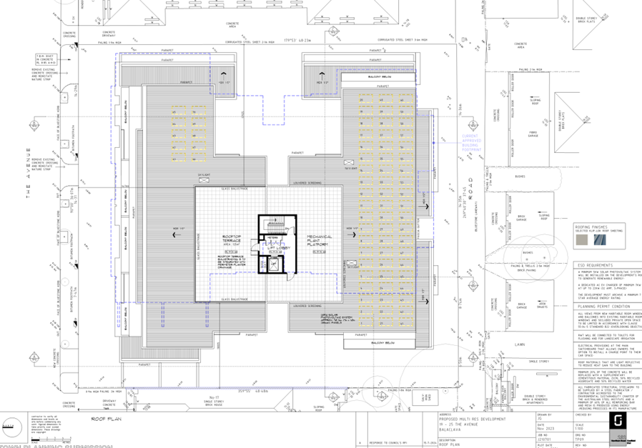
Is the building height and number of storeys compliant?
10.14 Clause 32.08-11 Maximum Building Height Requirement for a Dwelling, Small Second Dwelling or Residential Building states that a building construct for use as a dwelling must need exceed 11m or 3 storeys, noting that a basement is not considered a storey for the purposes of calculating the number of storeys in a building.
10.15 Clause 32.08-11 includes an exemption for land subject to the Special Building Overlay – that the maximum building height specified in the zone is the vertical distance from the minimum floor level determined by the relevant drainage or floodplain management authority to the roof or parapet at any point. The proposed development would not exceed 11m to this point, reaching a height of 10.9m.
10.16 There are a number of structures on the roof: mechanical plant platform 116sqm in area and with a screen 1.6m in height or to RL20.94m, a roof terrace including a balustrade, plus lift and stairs providing access to the roof terrace, and a lobby in between the stairs and lift. It is established through numerous VCAT cases, notably Aitken Property Pty Ltd v Hobsons Bay CC, Prahran Orrong Park Developments Pty Ltd c Stonnington CC [2017] VCAT1021, 17J Pty Ltd v Yarra CC [2023] VCAT 87, Abbott Street Sandringham v Bayside CC [2024] that these elements do not form part of the overall building as per the mandatory height specified in the zone.
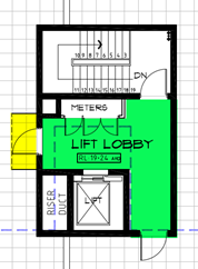
Figure 9: floor plan of the structure on top of the roof
10.17 With consideration of the cases, both the awning and the lobby are generally acceptable as they have been sited in the centre of the site to minimise visual impact, have a streamlined height that is consistent with the proposed building language, and their modest size.
10.18 Storey is defined at Clause 73.01 as:
That part of a building between floor levels. If there is no floor above, it is the part between the floor level and ceiling. It may include an attic, basement, built over car parking area, and mezzanine.
10.19 It is established in numerous VCAT cases that the lift, stair access, and associated lobby do not constitute a storey.
10.20 The proposal complies with the maximum building height and number of storeys as described at Clause 32.08-11.
Is the proposed car parking reduction acceptable?
10.21 Clause 52.06 Car Parking is used to ensure an appropriate number of car parking spaces are provided on the land and to ensure that car parking does not adversely affect the amenity of the locality. Sustainable transport alternatives to motor cars are encouraged.
10.22 The subject site is in the Principle Public Transport Network Area (PPTN) and therefore the rates in Column B of Table 1 to Clause 52.06-5 apply.
10.23 Car parking rates for dwellings in the PPTN are as follows:
|
Rate description |
Calculation of Requirement |
Provision |
|
1 space per one or two bedroom dwelling |
39 dwellings (8 x 1bed and 31 x 2bed) x 1 space = 39 spaces |
39 spaces |
|
2 spaces per three or more bedroom dwelling |
1 dwelling x 2 spaces = 2 spaces |
1 space |
|
0 spaces for visitors |
0 |
- |
|
Total |
41 spaces |
40 spaces |
10.24 Based on the statutory requirements, there is a reduction of 1 car parking space.
10.25 Applications to reduce the number of car parking spaces required are accompanied by a car parking demand assessment as described at Clause 52.06-7. This was provided by the applicant who provides the following justification to support the reduction (summarised):
· The Australian Bureau of Statistics 2021 Census data shows that 60% of residents in 3 bed apartments own 1 or less vehicles, indicating there is a market for 3 bed dwellings with only one space without the associated price tag.
· The site is well connected to transport and other services which may appeal to people who do not need to park an additional vehicle.
· Resident car parking demands are dependent on car parking provisions; a person with the need to park a vehicle is unlikely to occupy a dwelling without a car parking space.
10.26 The reduction in car parking spaces is acceptable as:
· The proximity of the site to train, tram, and bus services, bicycle and pedestrian infrastructure, and local services available on Carlisle Street.
· The traffic report demonstrates that The Avenue has the capacity to accommodate the increase in vehicle movements and traffic movements at the site can be managed to reduce queueing.
· Accommodating an additional car parking space in the basement would adversely impact other services in the basement, such as waste storage, residential storage, and bicycle parking, or require expansion of the basement and a subsequent reduction in permeable surfaces.
· The proposal will return more kerb to the street than it removes. The site currently has a frontage of 43.84m, 10.3m of which is crossovers and which would allow approximately 4 vehicles to park on-street. The proposal includes the closure of 2 crossovers and construction of one crossover, increasing the amount of kerb returned to the street and adding one additional on-street car parking space.
10.27 The traffic report refers to each dwelling having one car parking space, stating that there is market demand for 3 bed dwellings with only one space. Traffic have identified that the 3bed dwelling should have 2 spaces and the reduction allocated to a 1 bed dwelling. Given a 3 bed dwelling would likely house more people than a 1bed dwelling and generates a higher car parking demand, as supported by the car parking demand table, a condition will require that the 3 bed dwelling be allocated 2 spaces and one 1 bed dwelling be provided with zero spaces.
Would there be any unreasonable off-site amenity impacts?
10.28 A full Clause 55 assessment is available at Attachment 4. Some matters are described below:
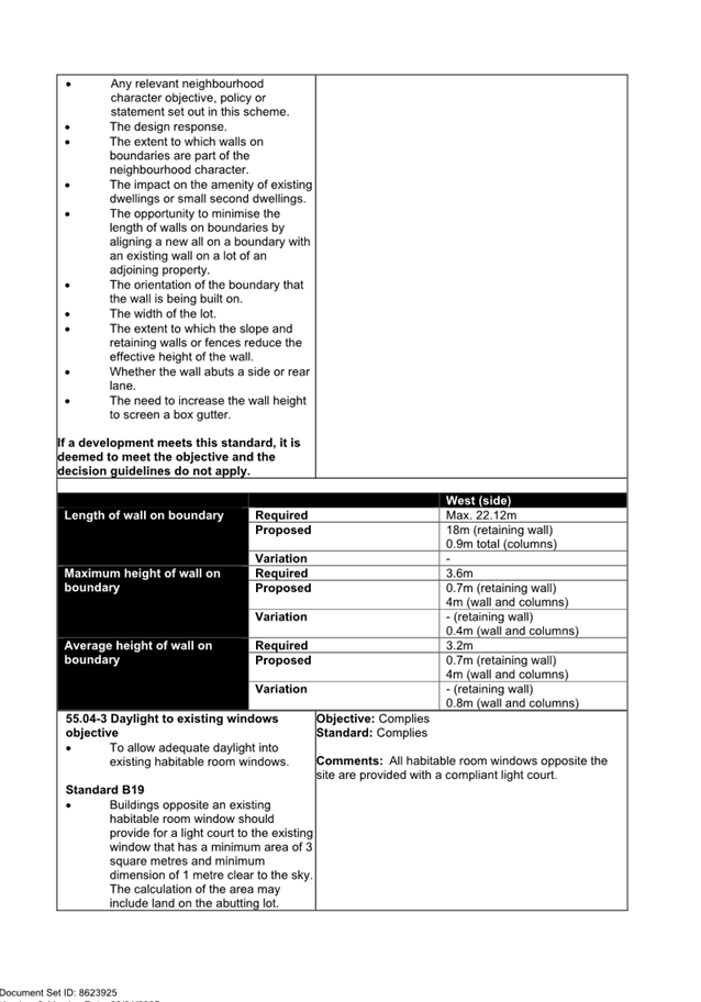
Clause 55.04-1 Side and rear setbacks Standard B17
10.29 The table below shows the setbacks required, provided, and where there is a non-compliance:
|
|
|
East (side) |
South (rear) |
West (side) |
|
Ground Floor |
Required |
1.03m |
1.05m |
1.18m |
|
Proposed |
1m |
3m (to wall) |
4.3m |
|
|
Variation |
0.03m |
- |
- |
|
|
First Floor |
Required |
2.055m |
2.09m |
2.6m |
|
Proposed |
2.2m |
2.5m (to fins) 3m (to wall) |
3.2m |
|
|
Variation |
- |
- |
- |
|
|
Second Floor |
Required |
5.89m |
6.09m |
6.09m |
|
Proposed |
4.7m (to fins) 5m (to wall) |
5.2m |
5m |
|
|
Variation |
1.19m 0.89m |
0.89m |
1.09m |
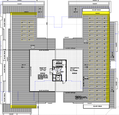
Figure 10: roof plan showing areas of non-compliance
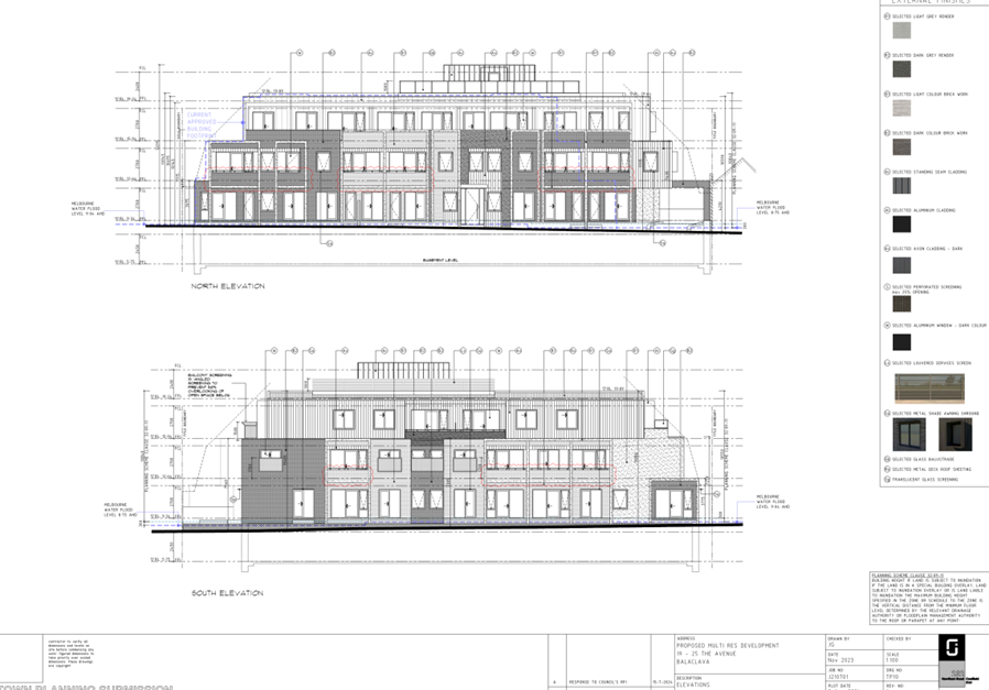
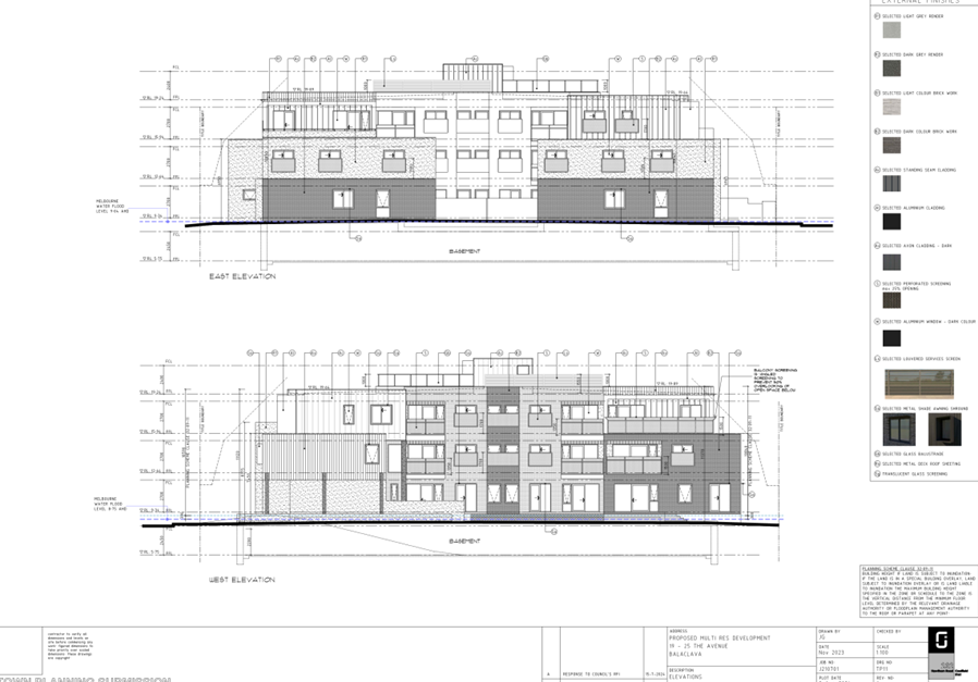
10.30 The variations are show highlighted in yellow below in the elevation drawings:
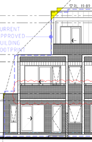
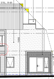
Figure 11: north elevation (left) and south elevation (right)
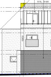
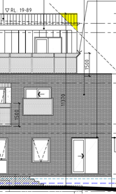
Figure 12: east elevation (left) and west elevation (right)
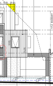
Figure 13: north elevation
10.31 With respect to the decisions guidelines:
· The design response is acceptable. The floor to ceiling heights proposed at 2.7m and are not excessive, and the built form is compatible with the surrounds. The proposal complies with the height and number of storey requirements.
· The non-compliance does not result in adverse amenity impacts such as overshadowing.
· There is no wall opposite the proposed wall; the wall is not matching another development.
· The wall abuts a rear lane to the south; the non-compliance on the southern elevation has less impact on the surrounding area consequently.
10.32 The non-compliant setbacks are acceptable as the variations are minor and isolated to small parts of the third storey.
Clause 55.04-5 Overshadowing open space Standard B21
10.33 The original proposal included Condition 1d) which required the proposal to comply with this standard. The Clause 55 assessment stated:
No 19.
At 9am the entire area of SPOS is in shadow.
By 10 am the area of SPOS that not in shadow has an area of 24 sqm and the increased area of shadowing is 8.41 sqm.
Given the unconstrained nature of the site, compliance should be achieved. A condition of the recommendation requires compliance.
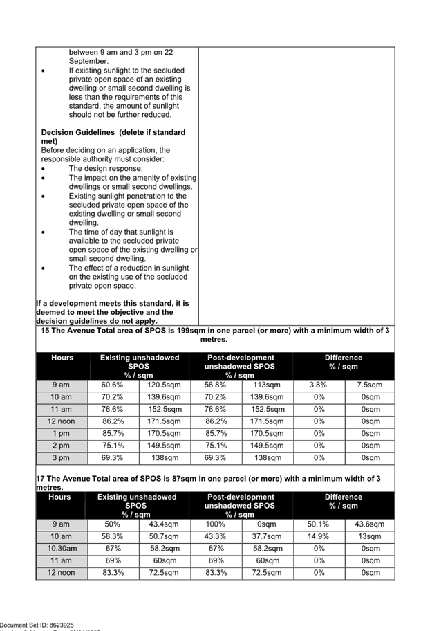
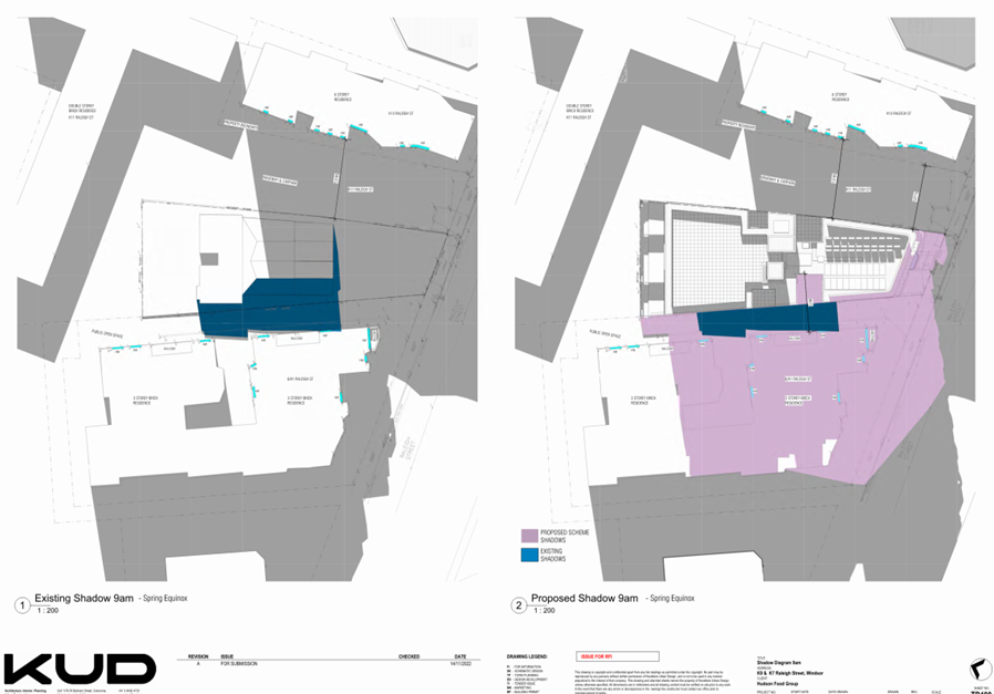
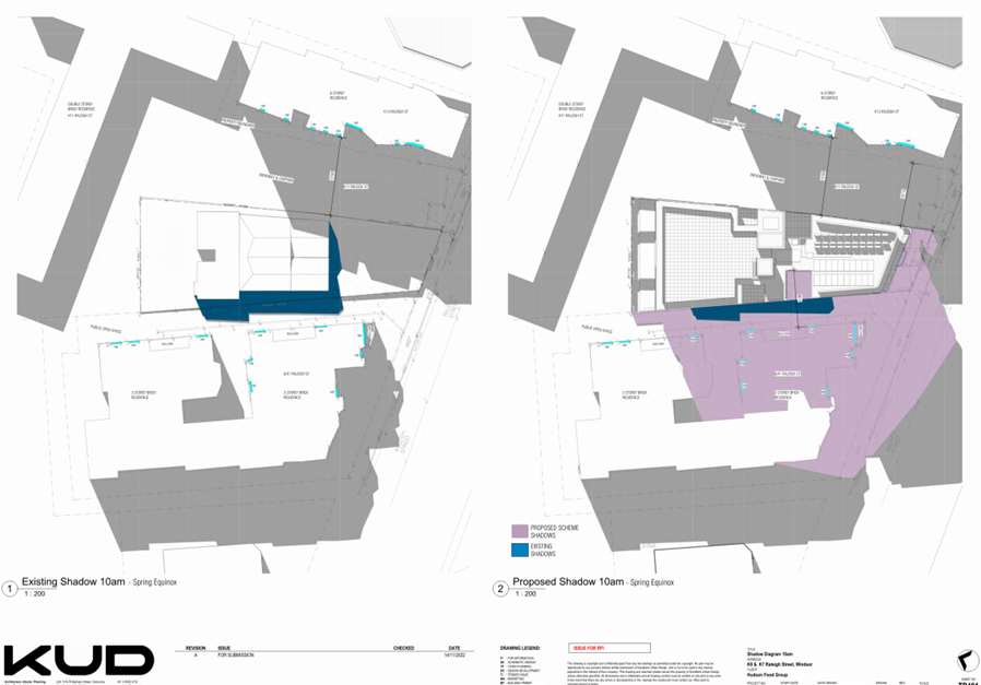
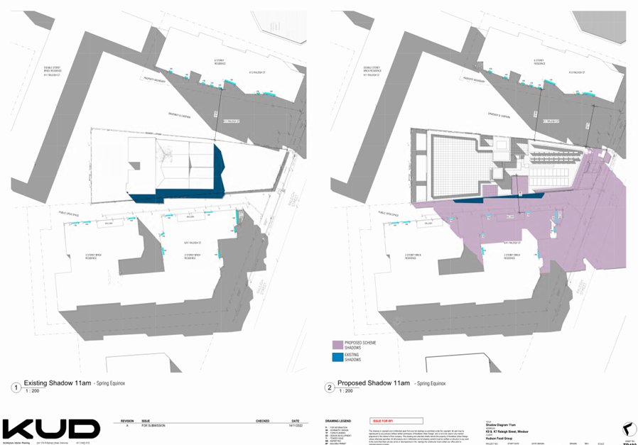
10.34 The shadow diagrams provided show that the proposal impacts the secluded private open space (SPOS) 15 and 17 The Avenue. Overshadowing to these 2 properties is assessed below in the tables.
|
15 The Avenue Total area of SPOS is 199sqm in one parcel (or more) with a minimum width of 3 metres. |
|||||||||
|
Hours |
Existing unshadowed SPOS % / sqm |
Post-development unshadowed SPOS % / sqm |
Difference % / sqm |
||||||
|
9 am |
60.6% |
120.5sqm |
56.8% |
113sqm |
3.8% |
7.5sqm |
|||
|
10 am |
70.2% |
139.6sqm |
70.2% |
139.6sqm |
0% |
0sqm |
|||
|
11 am |
76.6% |
152.5sqm |
76.6% |
152.5sqm |
0% |
0sqm |
|||
|
12 noon |
86.2% |
171.5sqm |
86.2% |
171.5sqm |
0% |
0sqm |
|||
|
1 pm |
85.7% |
170.5sqm |
85.7% |
170.5sqm |
0% |
0sqm |
|||
|
2 pm |
75.1% |
149.5sqm |
75.1% |
149.5sqm |
0% |
0sqm |
|||
|
3 pm |
69.3% |
138sqm |
69.3% |
138sqm |
0% |
0sqm |
|||
|
17 The Avenue Total area of SPOS is 87sqm in one parcel (or more) with a minimum width of 3 metres. |
|||||||||
|
Hours |
Existing unshadowed SPOS % / sqm |
Post-development unshadowed SPOS % / sqm |
Difference % / sqm |
||||||
|
9 am |
50% |
43.4sqm |
100% |
0sqm |
50.1% |
43.6sqm |
|||
|
10 am |
58.3% |
50.7sqm |
43.3% |
37.7sqm |
14.9% |
13sqm |
|||
|
10.30am |
67% |
58.2sqm |
67% |
58.2sqm |
0% |
0sqm |
|||
|
11 am |
69% |
60sqm |
69% |
60sqm |
0% |
0sqm |
|||
|
12 noon |
83.3% |
72.5sqm |
83.3% |
72.5sqm |
0% |
0sqm |
|||
|
1 pm |
87.4% |
76sqm |
87.4% |
76sqm |
0% |
0sqm |
|||
|
2 pm |
71.3% |
62sqm |
71.3% |
62sqm |
0% |
0sqm |
|||
|
3 pm |
57% |
49.5sqm |
57% |
49.5sqm |
0% |
0sqm |
|||
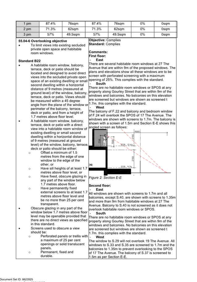
10.35 The standard is as follows:
Where sunlight to the secluded private open space of an existing dwelling or small second dwelling is reduced, at least 75 per cent, or 40 square metres with minimum dimension of 3 metres, whichever is the lesser area, of the secluded private open space should receive a minimum of five hours of sunlight between 9 am and 3 pm on 22 September.
If existing sunlight to the secluded private open space of an existing dwelling or small second dwelling is less than the requirements of this standard, the amount of sunlight should not be further reduced.
10.36 The impact on 15 The Avenue is within the standard as at least 40sqm of SPOS will remain unencumbered. There is sufficient information to be confident that the size of this SPOS ensures that this area receives compliant solar access.40sqm of SPOS should remain unencumbered at 17 The Avenue to comply with this standard.
10.37 The impact on 17 The Avenue is not within the standard as at least 40sqm of SPOS will not remain unencumbered. The diagrams show there is no change in overshadowing from 10.30am – 3pm, achieving 4.5 hours of standard solar access.
10.38 The applicant has provided the following to support this slight variance (summarised):
· The time of impact.
· The existing condition of 5 hours of sunlight is maintained.
· Existing trees at 17 The Avenue reduce the amenity of this area.
10.39 With respect to the decision guidelines:
· The design response is acceptable as the proposal will fit in with the surrounding area. The floor to ceiling heights provided are 2.7m and not excessive and the western parts of the building which are causing the overshadowing are numerically compliant. Overshadowing caused by compliance are more acceptable than overshadowing caused by non-compliance.
· The impact on the amenity of the overshadowing to 17 The Avenue would be minor. At 87sqm the SPOS is large but given it is narrow and south-facing, it is more vulnerable to overshadowing impact and any loss of sunlight would have an effect.
· Whilst existing shadow diagrams have not been provided throughout the day, the existing shadows can be estimated based on the information available. The site likely benefits from at least 40sqm of sunlight from 10.30am until 2pm, after which the boundary fence with 15 The Avenue will overshadow this area.
· The time of day of impact is early in the morning.
· The reduction in overshadowing would reduce the amenity of this area.
10.40 To comply with this standard the overshadowing at 10am would need to be removed. This would require an increased setback of S.37 of approximately 1.2m:
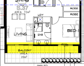
Figure 14: part of the building causing overshadowing to 17 The Avenue
10.41 The variance is acceptable as 17 The Avenue will retain reasonable amenity and the area causing overshadowing is compliant.
Clause 55.04-6 Overlooking Standard B22
10.42 The proposal complies with this standard and is described below:
East
10.43 There are several habitable room windows at 27 The Avenue that are within 9m of the proposed windows. The plans and elevations show all these windows are to be screened with perforated screening with a maximum opening of 25%. All balconies, except S.40, are shown with screens to 1.35m and are more than 9m from habitable windows at 27 The Avenue. Balcony to S.40 is not screened as it does not overlook habitable room windows or SPOS. The proposed screening either complies or exceeds the requirements of this standard.
South
10.44 There are no habitable room windows or SPOS at any property along Gourley Street that are within 9m of the windows and balconies. No balconies on this elevation are screened but windows are shown as screened to 1.7m. This screening goes beyond the requirements of the standard.
West
10.45 The balcony of F.22 and balcony and bedroom window of F.24 will overlook the SPOS of 17 The Avenue. The windows are shown with screens to 1.7m and the balcony with a screen of 1.5m. The window to S.29 will not overlook 19 The Avenue. All windows to S.33 and S.35 are screened to 1.7m and the balconies to 1.35m. The balcony of S.37 is screened to 1.5m.
10.46 Section E-E below shows the balconies along the western side and the use of angled screens to limit views into 17 The Avenue.
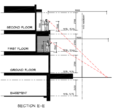
Figure 15: Section E-E
Rooftop terrace
10.47 The rooftop terrace is set back a minimum of 10m from each boundary, exceeding the 9m required by this standard.
Would there be any unreasonable on-site amenity impacts?
10.48 A full Clause 55 assessment is available at Attachment 4. Some matters are described below.
Clause 55.03-3 Site coverage Standard B8
10.49 This standard requires a maximum site coverage of 60% or 1272sqm and the proposal provides for 60.5% or 1282sqm. The proposal does not comply with this standard.
10.50 The non-compliance is acceptable as the non-compliance is minor, there are other examples of non-compliant site coverage in the area (e.g. 29, 31, 43-45 The Avenue), and the visual bulk of the proposal has been ameliorated through the design response such as materials and articulation.
Clause 55.03-5 Permeability and stormwater management Standard B9
10.51 This standard requires a minimum permeability of 20% or 424sqm. The discussion plans show the site permeability as being approximately 16% and the proposal provides for 15.3% or 325.5sqm of permeable surfaces. The proposal does not comply with this standard.
10.52 The planning report provided states that the proposal complies with this standard. The assessing officer finds that the proposal does not meet this standard. The diagram provided by the applicant showing areas of permeability includes areas that are not permeable, such as areas of paving along the southern boundary and the deck at the south-western corner.
10.53 The STORM report provided in the Sustainability Management Plan shows the permeability area as being incorrect. The assessing officer has undertaken a STORM assessment with an estimated ‘Remainder impervious areas’ of 698.5sqm instead of 599.90sqm from the current STORM, which would require the rainwater tank to increase from 20,000L to 25,000L to meet the minimum 100% STORM requirement.
10.54 Alternatively, some surfaces could be altered to be permeable:
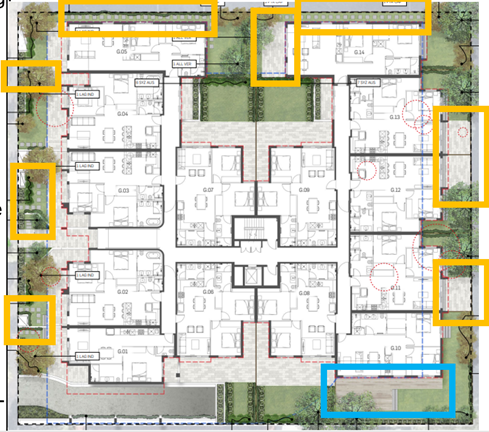
Figure 16: landscape plan indicating areas of paving that could be made permeable paving.
10.55 Changing these areas to permeable paving may not be quite enough to bring the land into compliance but would significantly reduce the non-compliance and the size of the rainwater tank required.
10.56 If the area in blue was made permeable the proposal would likely require with this standard, however this area is sensitive due to the adjoining Norfolk Island Pine and permeable paving in this location may be an inappropriate construction method that adversely impacts this tree.
10.57 Given the discussion plans in the original application supported a level of 16% permeability, a condition is recommended to require some of the paving at the rear of the site to be permeable paving and achieve a minimum permeable area of 16%. It is also recommended that the Sustainability Management Plan be updated to accurately reflect permeable surfaces at the site.
Are the current conditions of the planning permit appropriate or are amendments required?
10.58 Each existing condition of the permit that is recommended to change is shown below on the left, with the proposed changes to it described on the right.
|
Condition |
Justification |
|
Amended Plans Required 1. Before the development starts, amended plans to the satisfaction of the Responsible Authority must be submitted to and approved by the Responsible Authority. When approved, the plans will be endorsed and will then form part of the permit. The plans must be drawn to scale with dimensions and an electronic copy must be provided. The plans must be generally in accordance with the plans submitted with the application (prepared by AWA Architects and Interior Design, identified as Drawings TP01 through to TP20, Architect and dated as received on 24 January 2023) but modified to show: |
The applicant has requested this condition be changed to remove the reference to AWA Architects and Interior Design and the plan reference and does not request a replacement. It is recommended that this condition is updated to refer to the plans being considered in the subject amendment application.
|
|
a) All changes in accordance with the ‘discussion plans’ prepared by AWA Architects and Interior Design noted as Basement plan, Ground, First Floor Plan noted as plot date 12 July 2023, Second Floor Plan and Roof Plan noted as plot date 10 July 2023, North and South Elevation Plan noted as plot date 12 July 2023, East and West Elevation Plan noted as plot date 11 July 2011 and Section Plan noted as plot date 10 July 2023 but modified to show the changes required by Condition 1b to q below. |
The applicant has requested this condition be changed by altering the reference to the previous architect and plan references to the plans currently being considered. It is recommended that this condition be deleted given the plans considered are recommended to be added to Condition 1 and wholesale discussion plans are not being considered. |
|
b) the front setback of the building increased to comply with Clause 55.03-1 Standard B6 (Street Setback Objective). |
It is recommended this condition be deleted given the plans considered in the subject amendment application demonstrate compliance with this standard. |
|
c) All views from new habitable room windows and balconies into existing habitable room windows and secluded private open space to be limited in accordance with Clause 55.04-5 Standard B22 (Overlooking Objective). |
It is recommended this condition be deleted given this assessment finds that the proposal complies with this standard. |
|
d) Changes to the built form to ensure compliance with Clause 55.04-5 Standard B21 (Overshadowing Open Space Objective) as it affects the secluded private open space of No. 19 The Avenue. |
The applicant has requested this condition be deleted in full given 19 The Avenue is now part of the development site. It is recommended this condition be deleted. |
|
e) The materials schedule amended to change; • The dark Grey Colour Render (noted as R2) along the ground and first floor front elevation to brick in a similar colour. The brick finish to wrap around the side elevations for a depth of 1 apartment • The light render wall (noted as R1) on the west elevation above the basement entry, • The central section of the entry shown as Dark Grey Colour Render (noted as R2) changed to Axon Cladding Dark Colour (noted as Ax dark colour). |
The applicant has requested this condition be removed in full due to the new material palette proposed. The deletion of this condition is supported given the revised material palette. |
|
f) The location and cubic metre capacity of storage to each apartment in compliance with Clause 55.07-10 Standard B44 (Storage Objective) |
It is recommended that this condition be revised to require Typology 12 be revised to provide storage in accordance with Standard B44 as the Clause 55 assessment concludes this is the only dwelling that does not comply. |
|
g) Additional highlight window provided in Bedrooms 2 of apartments G1, 2, 9 and 10 to provide improved air circulation in accordance with Clause 55.07-15 Standard D49 (Natural Ventilation Objective) |
The applicant has requested that this condition be revised to reflect the changes to the proposal and the highlight windows that have been incorporated into the development. It is recommended that this condition be deleted in full as this assessment finds that the proposal complies with this standard. |
|
k) Details of the proposed roof materials that are light reflective to reduce heat gain to the building. |
It is recommended this condition is revised to add the following at the end ‘as required in the Sustainability Management Plan required at Condition 13 of this permit’ to ensure the roof colour is updated. The plans appear to show a dark colour roof. |
|
n) Any changes or notation required to accord with the amended Sustainability Management Plan required pursuant to Condition 11 of this permit. |
Revise this condition to refer to Condition 13. |
|
o) Any changes to the plans to accord with the amended Water Sensitive Urban Design Report required pursuant to Condition 13 of this permit. |
Revise this condition to refer to Condition 15. |
|
p) Any Changes to the plans to accord with the amended Waste Management Plan required pursuant to Condition 16 of this permit. |
Revise this condition to refer to Condition 20. |
|
q) Any changes required to comply with the Melbourne Water requirements at Condition 18 through 21 of this permit. |
Revise this condition to refer to Melbourne Water Conditions 23 to 26. |
|
Ongoing involvement of the Architect 4. The applicant must retain AWArchitects and Interior Design to complete the design and provide architectural oversight of the delivery of the detailed design as shown in the endorsed plans and endorsed schedule of materials and finishes during the construction except with the prior written approval of the Responsible Authority. |
AWArchitects and Interior Design no longer appear to be involved in this application and the plans provided have been prepared by Jason Goldberg Design. It is recommended this condition is revised to reflect the change in designer.
|
|
Amended Sustainability Management Plan 11. Prior to the plans being endorsed under condition 1 of this permit, an amended Sustainability Management Plan (SMP) must be submitted to and be approved by the Responsible Authority. The SMP must be generally in accordance with the SMP by Ecocity Sustainability Consultants dated May 2022 but modified to be in accordance with all changes required pursuant to Condition 1 of this permit. Where alternative ESD initiatives are proposed to those specified in this condition, the Responsible Authority may vary the requirements of this condition at its discretion, subject to the development achieving equivalent (or greater) ESD outcomes. When approved, the Assessment will be endorsed and will then form part of this permit and the project must incorporate the sustainable design measures listed. |
Renumber this condition to Condition 13. The Sustainability Management Plan provided has been prepared by a different company than that referred to in this condition. It is recommended that the reference to Ecocity Sustainability Consultants dated May 2022 is revised to refer to ECM Group, Revision 1, dated 29 July 2024. This condition is also recommended to be amended to include the changes recommended by Sustainability. |
|
Amended Water Sensitive Urban Design Report 13. Prior to the plans being endorsed under Condition 1 of this permit, an amended Water Sensitive Urban Design (Stormwater Management) Report must be submitted to and approved by the Responsible Authority. The report must be generally in accordance with the SMP by Eco-city Sustainability Consultants dated May 2022 and must demonstrate how the proposed stormwater devices will be maintained on an on-going basis. This can be demonstrated by providing a maintenance manual including the following information; • A full list of maintenance tasks, • The required frequency of each maintenance task (monthly, annually etc.), • Person responsible for each maintenance task. When approved, the Report will be endorsed and will form part of this permit. |
Renumber this condition to Condition 15. The Sustainability Management Plan provided has been prepared by a different company than that referred to in this condition. It is recommended that the reference to Ecocity Sustainability Consultants dated May 2022 is revised to refer to ECM Group, Revision 1, dated 29 July 2024. |
|
Amended Waste Management Plan 16. Prior to the plans being endorsed under Condition 1, an amended Waste Management Plan (WMP) must be submitted to and approved by the Responsible Authority. The WMP must be generally in accordance with the WMP submitted by One Mile Grid dated 11 April 2022 but modified to include: a) The correct numbers of units/bedrooms on pages 6 and 7 b) Allocated space for glass recycle bins c) An increased collection frequency for both waste and recycling. d) Allocation of storage space for hard/green waste /e-waste with notes on how residents with bulky items will access the bin room. When approved the WMP will be endorsed and form part of the permit. |
Renumber this condition to Condition 20. A new Waste Management Plan prepared by One Mile Grid has been submitted. It is recommended this condition is updated to revise the reference to 11 April 2022 to 6 August 2024. Delete existing conditions a)-d) as Waste have not identified theses as outstanding issues in the Waste Management Plan. Add conditions required by the Waste team as conditions e) and f). |
10.59 The following new conditions are considered necessary based on the changes that form part of this proposal:
r) Any changes required to accord with the arborist report required at Condition 10 of this permit.
s) Any changes required to accord with the revised landscape plan required at Condition 11 of this permit.
t) Location of the urban art strategy required by Condition 22 of this permit.
u) Notation of the rainwater tank volume and connection details for stormwater reuse on the basement plan.
v) An access hatch to the rainwater tank for maintenance purposes on the basement plan.
w) Notation that identifies the car parking allocation for each unit. 2 car parking spaces must be allocated to the 3bed dwelling and one 1bed dwelling is to be allocated no car parking space.
x) The bottom 1 in 8 grade transition of the ramp with a minimum 2.5m length.
y) Minimum 2.2m headroom as per AS2890.1 at the entrance to the basement when the roller door is at the opened position and throughout the basement.
z) Ceiling height in waste collection point to enable the 6.4m rear mini loader to lift the bins.
aa) Increase the height of the wall between the accessway and bedroom window of G.01 to 1.4m as required by Clause 55.03-1 Standard B15 (Parking Location Objective).
bb) The mailbox size and location to comply with the requirements of Clause 55.07-18 Standard B52 (Site Services Objective).
cc) Paved areas at the rear of the site, outside of the Tree Protection Zone of Trees 1 and 2 at 17 The Avenue, as being permeable paving to achieve an overall minimum permeable area of 16% to satisfy Clause 55.05-3 Standard B9 (Permeability and Stormwater Management Objective).
dd) Changes required by Ironbark Environmental Arboriculture, dated 28 March 2024 and shown on TP06 prepared by Jason Goldberg Design received 14 November 2024 to protect Tree 1 at 17 The Avenue.
· New Condition 10 which requires a revised arborist report to be prepared in accordance with revised plans.
· New Condition 11 which requires a revised landscape plan to be provided, plus changes recommended by the Landscape team to the landscape plan. Renumber the subsequent conditions.
· New Condition 17 for general amenity.
· New Condition 18 for dust control.
11. COVENANTS
11.1 The applicant has completed a restrictive covenant declaration form declaring that there is no restrictive covenant on the titles for the subject site known as:
|
Address |
Volume and Folio Number |
Lot and Plan Number |
|
19 The Avenue |
Volume 03497 Folio 369 |
Lots 1 and 2 on Title Plan 663658D |
|
21 The Avenue |
Volume 03497 Folio 369 |
Lot 1 on Title Plan 629809C |
|
23 The Avenue |
Volume 03967 Folio 255 |
Lots 1 and 2 on Title Plan 247822P |
|
25 The Avenue |
Volume 02202 Folio 318 |
Lots 1 and 2 on Title Plan 746670D |
12. OFFICER material OR general INTEREST
12.1 No officer involved in the preparation of this report has declared a material or general interest in the matter.
13. CONCLUSION
13.1 Clause 71.02 of the planning scheme requires the decision-maker to integrate the range of policies relevant to the issues to be determined and balance the positive and negative environmental, social and economic impacts of the proposal in favour of net community benefit and sustainable development. When considering net community benefit, fair and orderly planning is key; the interests of present and future Victorians must be balanced; and the test is one of acceptability.
13.2 The proposal has been considered against the Port Phillip Planning Scheme as it currently applies and is found to be supported by policy that encourages this type of development in this location. The proposal has been designed respectfully in the context of the surrounding built environment and the future occupants. The proposed car parking reduction is acceptable. The proposal overall has an acceptable impact, subject to conditions.
13.3 It is recommended that Council issues a Notice of Decision to Grant an Amended Planning Permit.
|
ATTACHMENTS |
1. Advertised Plans and Shadow Diagrams 2. Advertised Landscape Plans 3. Site Plan and Controls 4. Clause 55 Assessment 5. Discussion Plans |
Planning Committee
26 February 2025
|
K7 Raleigh Street, Windsor - PDPL/00789/2022 |
|
|
location/address: |
K7 Raleigh Street, Windsor, VIC 3181 |
|
Executive Member: |
Brian Tee, General Manager, City Growth and Development |
|
PREPARED BY: |
Matthew Schreuder, Principal Planner |
1. PURPOSE
1.1 To determine an application for the construction of a multi-storey building with roof terrace and basement carparking in a Residential Growth Zone and the reduction of the car parking requirements of Clause 52.06.
2. EXECUTIVE SUMMARY
|
Ward: |
Lakeside |
|
Trigger
for determination |
More than 16 objections and a reduction in residential car parking |
|
ApplicATION NO: |
PDPL/00789/2022 |
|
Applicant: |
Edwards Park Windsor Pty Ltd |
|
Existing use: |
Residential |
|
Abutting uses: |
Residential |
|
Zoning: |
Residential Growth Zone – Schedule 1 |
|
Overlays: |
Design and Development Overlay – Schedule 13 (Shrine Vista) |
2.1 This application proposes the construction of a nine-storey building comprising 42 apartments. The proposal includes 1 x one-bedroom apartment, 38 x two-bedroom apartments and 3 x three-bedroom apartments. Basement car parking is proposed containing 34 car spaces in stackers and 42 bicycle spaces accessed from Raleigh Street.
2.2 The proposal requires the provision of 45 car parking spaces to satisfy Clause 52.06 (Car Parking). 34 Spaces are provided within car stackers. Therefore, the application seeks a waiver of 11 spaces.
2.3 The proposal includes the demolition of the two dwellings that currently occupy the site. No planning permit is required for demolition.
2.4 The planning permit triggers for the application are:
· To construct two or more dwellings on a lot pursuant to Clause 32.07-6 of the Residential Growth Zone.
· To construct a building or construct or carry out works pursuant to Clause 43.02-2 of the Design and Development Overlay (Shrine Vista).
· To reduce the number of car parking spaces required under Clause 52.06-5 (Car Parking)
2.5 The application was advertised in October 2024 and received 21 objections. Key concerns raised include overlooking, overshadowing and daylight impacts, bulk and scale, walls on boundaries, neighbourhood character, car parking and traffic, mistakes on the plans and impacts on trees.
2.6 A consultation meeting was held 10 December 2024. The meeting was attended by 2 Councillors, the applicant, objectors and planning officers. The meeting did not result in changes to the proposal.
2.7 The proposal is acceptable for the following reasons:
· The strategic direction of the Port Phillip Planning Scheme, in particular the Residential Growth Zone, supports increased residential densities in strategic locations with proximity to jobs, services and public transport.
· The scale of the building is commensurate with other residential and commercial development proximate to the site.
· The proposal provides an appropriate level of internal amenity for future residents.
· Off-site amenity impacts are acceptable.
· The provision of 34 car spaces is acceptable given proximity to numerous modes of public transport and location within the Principal Public Transport Network (PPTN).
· The provision of 42 bicycle spaces exceeds 12 spaces required by Clause 52.34 – Bicycle Facilities. This further supports the reduction to the car parking requirements.
· The proposal will not obscure views of the Shrine of Remembrance, consistent with the design objectives of Schedule 13 of the Design and Development Overlay.
2.8 The concerns raised by the objectors are acknowledged and discussed within this report.
2.9 The proposal is recommended for approval, subject to the conditions below.
|
3. RECOMMENDATION 3.1 That the Responsible Authority, having caused the application to be advertised and having received and noted the objections, issue a Notice of Decision to Grant a Permit 3.2 That a Notice of Decision to Grant a Permit be issued for the construction of two or more dwellings on a lot in a Residential Growth Zone and a reduction of the car parking requirements of Clause 52.06 at K7 Raleigh Street, Windsor 3.3 That the decision be issued as follows: Amended Plans required 1 Before the development starts, amended plans to the satisfaction of the Responsible Authority must be submitted to and approved by the Responsible Authority. When approved, the plans will be endorsed and will then form part of the permit. The plans must be drawn to scale with dimensions and an electronic copy must be provided. The plans must be generally in accordance with the plans prepared by Kavellaris Urban Design titled Proposed multi Residential apartment development- K7 – K9 Raleigh Street, Windsor, plan No’s Sk.01, TP000, TP1.01-TP1.08, TP2.01-TP2.09, TP009, TP010, TP100-TP106, TP200-TP204, TP300-TP302, TP400-TP406, TP500-TP503, project No. 20-020 and Council date stamped 18 December 2023) but modified to show: a) Location, area in cubic metres and allocation of storage areas for each dwelling in accordance with Standard D21 of Clause 58.05-4 – Storage Objective. b) Unit types 1.1, 1.2, 1.3 and 1.5 with location of toilet and wash basins swapped to make 1 bathroom per apartment compliant with standard D18 of Clause 58.05-1 - Accessibility Objective. c) Notations relating to permeability on floor plans. d) The following ESD notations on the plans i. EV chargers to each car stacker ii. WELS rating iii. 20 x 350W = 7 kW PV to power building and EV charging. e) Any changes required by Condition 6 (Sustainability Management Plan), Condition 8 (Water Sensitive Urban Design), Condition 14 (Landscape Plan), and Condition 16 (Arborist Report) No Alterations 2 The layout of the site and the size, levels, design and location of buildings and works shown on the endorsed plans must not be modified for any reason without the prior written consent of the Responsible Authority. No change to external finishes 3 All external materials, finishes and colours as shown on the endorsed plans must not be altered without the written consent of the responsible authority. No equipment or services 4 Any plant, equipment or domestic services visible from the primary street frontage (other than a lane) or public park must be located and visually screened to the satisfaction of the Responsible Authority. Urban Art Plan 5 Before the development is occupied, an urban art plan in accordance with Council’s Urban Art Strategy must be submitted to, be to the satisfaction of and approved by the Responsible Authority. The value of the urban art must be at least 0.5% of the total building cost of the development to the satisfaction of the Responsible Authority. Urban art in accordance with the approved plan must be installed prior to the occupation of the building to the satisfaction of the Responsible Authority. Updated Sustainability Management Plan 6 Before the plans are endorsed under Condition 1 of this permit, an updated Sustainability Management Plan (SMP) must be submitted to and approved by the Responsible Authority. The updated SMP must be generally in accordance with the SMP submitted with the application titled Town Planning – Proposed Class 2 & 7a Development, dated 11 July 2022, authored by Enrate (Aust) Pty Ltd, Version v1, but modified to address the following: a) The development to be gas free. b) Apartment types to meet the minimum heating loads. c) Apartments type 8 to meet average NatHERS star ratings. d) P.85 Preliminary Energy Efficiency Assessment NCC 2016 updated to reference current standard. Where alternative ESD initiatives are proposed to those specified in this condition, the Responsible Authority may vary the requirements of this condition at its discretion, subject to the development achieving equivalent (or greater) ESD outcomes. When approved, the updated SMP will be endorsed and will then form part of this permit. The ESD initiatives in the endorsed SMP must be fully implemented and must be maintained throughout the operational life of the development to the satisfaction of the Responsible Authority. As Built Report for Environmentally Sustainable Design measures. 7 Before the development is occupied, an As-Built report (or reports) for Environmentally Sustainable Design measures is to be provided from a suitably qualified person or company, must be submitted to and endorsed by the Responsible Authority. The Report/s must confirm and provide supporting evidence that all ESD initiatives in the endorsed SDA/SMP and WSUD report have been implemented in accordance with the approved plans/documents to the satisfaction of the Responsible Authority. The ESD and WSUD initiatives must be maintained throughout the operational life of the development to the Satisfaction of the Responsible Authority. Water Sensitive Urban Design Response 8 Before the plans are endorsed under Condition 1 of this permit, a Water Sensitive Urban Design (Stormwater Management) Report must be submitted to the Responsible Authority in electronic format. When approved, the Water Sensitive Urban Design Report will be endorsed and will then form part of this permit. The report must provide: a) Details of how the water sensitive urban design stormwater treatment measures will be maintained on an on-going basis. This must be demonstrated by providing a maintenance manual including the following information: i. A full list of maintenance tasks. ii. The required frequency of each maintenance task (monthly, annually etc.). iii. Person responsible for each maintenance task. iv. Access to underground rainwater tanks
Car And Bicycle Parking Layout 9 Before the building is occupied, the areas set aside for the parking of vehicles and bicycles and access lanes as shown on the endorsed plans must, to the satisfaction of the Responsible Authority, be: a) Constructed. b) Properly formed to such levels that may be used in accordance with the plans. c) Surfaced with an all weather surface or seal coat (as appropriate). d) Drained and maintained. e) Line marked to indicate each car space, visitor space, bicycle space, loading bay and/or access lane. f) Clearly marked to show the direction of traffic along access land and driveways. Parking and Loading Areas Must Be Available 10 Car and bicycle parking and loading areas and access lanes must be developed and kept available for those purposes at all times and must not be used for any other purpose such as storage to the satisfaction of the Responsible Authority. Lighting 11 External lighting of the areas set aside for car parking, access lanes and driveways must be designed, baffled and located to the satisfaction of the Responsible Authority to prevent any adverse effect on adjoining land. Vehicle Crossings 12 Before the building is occupied, vehicle crossings must be constructed in accordance with Council’s current Vehicle Crossing Guidelines and standard drawings to the satisfaction of the Responsible Authority. All redundant crossings must be removed and the footpath, naturestrip, kerb and road reinstated as necessary at the cost of the applicant/owner and to the satisfaction of the Responsible Authority. Car Parking Stacker Maintenance and Provision 13 The mechanical car stackers are to be maintained in a good working order and be permanently available for the parking of vehicles in accordance with their purpose, to the satisfaction of the Responsible Authority. Prior to the occupation of the approved development, the owner/permit holder must prepare and have approved in writing by the Responsible Authority, a car stacker system management plan including but not limited to the following: a) Allocation of car parking spaces according to vehicle size and type. b) Ongoing maintenance of the car stacker system. c) Instructions to owners/occupiers about the operation of the car stacker system. d) Communicating to prospective residents about the availability of car stacker spaces and sizes. Once approved this document must be complied with to the satisfaction of the Responsible Authority and must not be varied except with the written approval of the Responsible Authority. Landscape Plan 14 Before the development starts (other than demolition or works to remediate contaminated land), a detailed Landscape Plan must be submitted to, approved by and be to the satisfaction of the Responsible Authority. When the Landscape Plan is approved, it will become an endorsed plan forming part of this Permit. The Landscape Plan must incorporate: a) A survey plan, including botanical names, of all existing vegetation/trees to be retained. b) Buildings and vegetation (including botanical names) on neighbouring properties within 3m of the boundary. c) Significant trees greater than 1.5m in circumference, 1m above ground. d) A planting schedule of all proposed vegetation including botanical names; common names; pot sizes; sizes at maturity; quantities of each plant; and details of surface finishes of pathways and driveways. e) Landscaping and planting within all open space areas of the site. f) Water sensitive urban design consistent with Condition 8. g) 1 advanced tree stock (minimum 45 litre pot or bag 2.5 metres tall when planted unless otherwise agreed to in writing by the Responsible Authority) within each of the following areas: i. Within the front setback of Apartment 0.4 and within the rear setback of apartments 0.1, 0.2 and 0.3. ii. Trees are not to be sited over easements. Completion of Landscaping 15 The landscaping as shown on the endorsed Landscape Plan must be carried out and completed to the satisfaction of the Responsible Authority before the occupation of the development and/or the commencement of the use or at such later date as is approved by the Responsible Authority in writing. Arborist report 16 Before the development starts, a report and plan by a suitably qualified Arborist to comply with AS 4970 - 2009 Tree protection on development sites setting out how the 2 existing (Casuarina cunninghamiana) trees at (K11 Raleigh Street) will be protected during and after construction, must be submitted to, approved by and be to the satisfaction of the Responsible Authority. When approved the report and plan will be endorsed and form part of the permit. The tree protection measures outlined in the report must be complied with to the satisfaction of the Responsible Authority.
Soundproofing of plant and equipment 17 All external plant and equipment must be acoustically treated or placed in soundproof housing to reduce noise to a level to the satisfaction of the responsible authority. Construction over easements 18 No buildings or works are to be constructed over any easement or other restriction on the land or any sewers, drains, pipes, wires or cables under the control of a public authority without the prior written consent of the relevant authority and the Responsible Authority. Noise Attenuation for Apartments 19 External traffic noise intrusion within apartment bedroom and living areas (upon completion; with furnishing within the spaces and with windows and doors closed) and measured in accordance with AS/NZS 2107:2016 ‘Acoustics - Recommended Design Sound levels and Reverberation Times for Building Interiors’ must comply with the following: a) Between 10pm and 6am in bedrooms areas must not exceed LAeq, 8hour 35dB(A). b) Between 6am and 10pm in living rooms must not exceed LAeq (16hour) 40dB(A). A report prepared by a suitably qualified acoustic professional demonstrating compliance with the requirements of this condition must be submitted to the responsible authority prior to the issue of any Certificate of Occupation or Certificate of Final Inspection for the development allowed by this Permit). Time for Starting and Completion 20 This permit will expire if one of the following circumstances applies: a) The development is not started within two years of the date of the permit. b) The development is not completed within four years of the date of the permit. The Responsible Authority may extend the periods referred to if a request is made in writing: · Before or within 6 months after the permit expiry date, where the development allowed by this permit has not yet started; and · Within 12 months after the permit expiry date, where the development allowed by the permit has lawfully started before the permit expires. |
4. RELEVANT BACKGROUND
4.1 There is no relevant history or background for this application.
5. PROPOSAL
5.1 The application is for the construction of a multi-storey building with roof terrace and basement carparking. The development will comprise 42 apartments with a mix of 1, 2 and 3 bedroom apartments. The basement provides 34 car spaces across three stackers and 42 bicycle spaces. The basement is accessed via Raleigh Street and also provides for waste collection and loading and unloading for small delivery vans.
5.2 A 221 sqm communal roof terrace is also proposed.
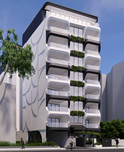
Figure 1 - Artist render of the proposed development.
5.3 Further particulars of the proposal are outlined below.
Basement Level
5.4 The basement is accessed via a ramp along the western side of the site frontage off Raleigh Road. The basement contains three separate car stacker systems.
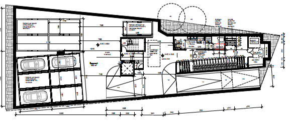
Figure 2 - Basement level.
Ground floor
5.5 The ground floor consists of a central lobby accessed from a pedestrian path at the centre of the Raleigh Street frontage. The small lobby area contains a mail room, access to storage lockers, the lift and stairs and access to four apartments.
5.6 Ground floor apartments comprise one single bed apartment with a frontage and courtyard to Raleigh Street and three x 2-bedroom apartments with direct access to an area of secluded private open space at the rear of the site. Unit 1, located on the western side of the building also has access to 2 additional areas of secluded open space by way of two light courts. Unit 3 has access to a light court servicing two bedrooms.
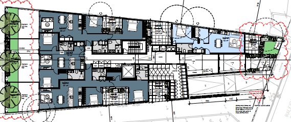
Figure 3 - Ground floor.
Levels 1-7
5.7 Levels 1-7 provide identical layouts and comprise of 5 x two-bedroom apartments. Each apartment is provided with a balcony with direct access from an open plan living area. The balconies vary in size from 12 – 14 square metres. All apartments have daylight access from the balconies as well as light courts for bedrooms.
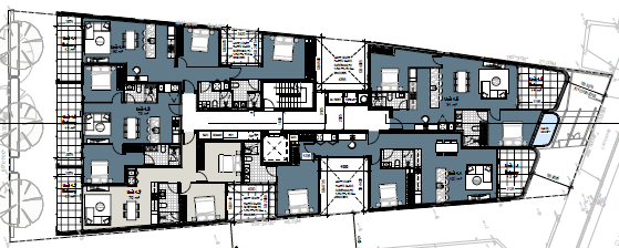
Figure 4 - Level 1-7.
Level 8
5.8 Level 8 accommodates 3 x three-bedroom apartments. Each has a balcony with direct access from an open plan living area and from one of the 3 bedrooms. Daylight is provided from the balconies as well as 4 light courts.
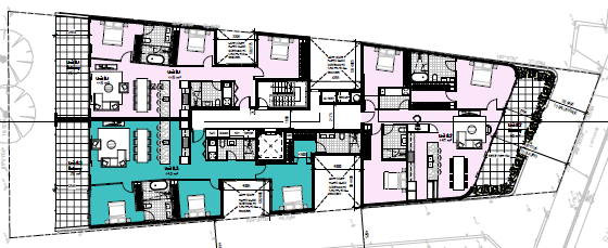
Figure 5- Level 8.
Roof level
5.9 The roof terrace contains a communal space with an area of 211 square metres. The area has BBQ and seating. A section of the terrace is roofed. This makes the terrace the 9th storey of the building.
5.10 The roof area also contains 20 x 350w solar panels and air-conditioning units.
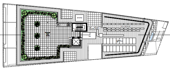
Figure 6 – Roof terrace.
Other features of the proposal
5.11 The proposal will have a maximum height of 36.6 metres. The total site coverage is 77.2% and the permeable surface area will be 6.9%.
5.12 Private open space areas on the balconies face either north or south. The light courts have an east or west orientation.
5.13 Windows within the light courts are provided with fritted glass to a height of 1.7 metres above finished floor level.
5.14 A full set of the development plans is at Attachment 1.
6. SUBJECT SITE AND SURROUNDS
6.1 The following table provides details of the subject site and surrounds:
|
|
Description of Site and Surrounds |
|
Site Area |
The total site area of the two parcels is 725 square metres. |
|
Existing building and site conditions |
The sites currently contain a pair of attached duplex dwellings that are single storey brick dwellings with pitched stale tile roofs. Each dwelling is provided with vehicle access at the front of the site and room for a car to be parked onsite within the front setback. The dwellings are the last of the traditional older style dwellings located within the block bounded by Raleigh Street, St Kilda Road, Punt Road and High Street Various trees are located on the site and a large Canary Island Palm is located along the shared western property boundary with K1. Other vegetation is located along the side boundaries within the common property areas of K11 to the north and east of the site.
Figure 7 - Subject land, K7 and K9 Raleigh Street. Source: Council Officer. Feb. 2025 |
|
Surrounds / neighbourhood character |
The surrounding area is located within the Commercial Zone to the east and south and the Residential Growth Zone to the north and east. The area is characterised by large scale buildings generally ranging in height between 5-17 storeys and more modest double storey apartment buildings. Land use is predominately residential with old and newer apartment buildings surrounding the site. There are a number of commercial buildings with proximity of the site including the Calvary Residential Age Care Centre located at 101 Punt Road. To the north is K11 Raleigh Road which contains a two-storey apartment building. The building is towards the northern side of the site and a communal car parking space separates the building from the subject land.
Figure 8 – K11 Raleigh Street to the north of the subject site. Source Nearmap. December 2024. To the east, over the common property accessway for K13 is an 8-storey building used for student accommodation. The building is constructed with a sheer built form with limited side and rear setbacks. Light courts are provided along the side elevations and habitable room windows are also provided along the side elevations.
Figure 9 – K13 Raleigh Road- Student Accommodation. Source: Council Officer. Feb. 2025 To the south is Raleigh Street. On the opposite side of Raleigh Street is a five storey apartment development and a 7-storey commercial building. The apartment building provides landscaping within the front setback which includes the provision of medium canopy trees that softens the built form. The commercial building also provides trees along the side of the building which has its frontage to St Kilda Road.
Figure 10 - K2 Raleigh Street, opposite the subject site. Source: Council Officer. Feb. 2025 To the west is K1 Raleigh Street which contains a 3-storey apartment building. The building is setback from the common boundary by approximately 4.5 to 4.6 metres. The building has an articulated built form with a varied front setback. Windows and balconies are located along the eastern elevation with views towards the subject site. The site has street level under-croft car parking accessed from a crossover at the centre of the frontage. Limited landscaping is provided across the site including a large Lemon Scented Gum within the front setback. The site also has a Canary Island Palm that is partly located on the subject site.
Figure 11 -K1 Raleigh Street to the west of the subject site. Source: Council Officer. Feb. 2025 Newer development with the area displays an increased scale and height to what has been traditionally present.
Figure 12 - 613 St Kilda Road, two properties to the west of the subject site. Feb. 2025 |
|
Access to public transport and services |
The site is located with the Principal Public Transport Network area. It is well serviced by public transport with trams along St Kilda Road approximately 130 metres to the west of the site and Prahran Station 1 km to the northeast of the site. The site is also well serviced by other public service and activity centres, such as the St Kilda Road Major Activity Centre approximately 580 m to the south. The site is also less than 3.5 km from the Melbourne Central Business District. |
|
Aerial photo |
Figure 13 - Aerial photograph of subject site (green marker) and surrounds. Source: Nearmap December 2024. |
7. Permit Triggers
7.1 The following zone and overlay controls apply to the site, with planning permission required as described. A Zoning Map is contained at Attachment 2.
|
Zone or Overlay |
Why is a permit required? |
|
Clause 32.07 Residential Growth Zone – Schedule 1 Individual Sites and Precincts (RGZ1) |
Use A planning permit is not required to use the land for a dwelling. Works A planning permit is required to construct two or more dwellings on a lot pursuant to Clause 32.07-5. An apartment development of five or more storeys, excluding a basement, must meet the requirements of Clause 58 (Apartment Developments) of the Port Phillip Planning Scheme. |
|
Clause 43.03 Design and development Overlay – Schedule 13 – Shrine Vista (DDO13) |
A permit is required to construct a building or construct or carry out works, pursuant to Clause 43.02-02 for buildings over 33 metres in height. The total building height is 36.69 AHD and therefore a permit is triggered under the DDO13. |
|
Clause 52.06 Car Parking |
A permit is required to reduce (including to zero) the number of car parking space required under Clause 52.06 -5 or in a schedule to the parking overlay. The proposal requires the provision of 45 car parking spaces for the 42 apartments. The development provides 34 spaces, therefore the proposal seeks a reduction of 11 spaces. |
|
Clause 52.34 Bicycle Facilities |
The development would provide more than the number of bicycle spaces required under Clause 52.34 which in development of four or more storeys is 1 to each 5 dwellings and one visitor space for each 10 dwellings. This equals a requirement of 12 spaces. The application proposes 42 spaces. Therefore, no permit is required for a reduction in spaces. |
8. PLANNING SCHEME PROVISIONS
8.1 The following provisions of the Metropolitan Planning Strategy are relevance to this application:
Clause 02: Municipal Planning Strategy
02.01 – Context
02.02 – Vision
02.03 – Strategic Vision
02.04 – Strategic Framework Plans
8.2 The following provisions of the Planning Policy Framework are relevance to this application:
Clause 11: Settlement
11.01-1R1 - Settlement – Metropolitan Melbourne
11.02 - Managing Growth
Clause 15: Built Environment and Heritage
15.01-1L-02 - Urban Design
15.01-2L-01 - Building design
15.01-2L-02 - Environmentally Sustainable Development
15.01-2L-03 - Urban Art Clause
Clause 16: Housing
16.01-1L-02 - Housing Diversity
16.01-1L-02 - Location of Residential Development
Clause 18: Transport
18.01-1L-01 - Land and Transport Integration
18.02-4L-01 - Car Parking
18.02-4L-02 - Loading Facilities
Clause 19: Infrastructure (St Kilda Road and Queens Road)
19.03-3L - Stormwater Management (Water Sensitive Urban Design)
19.03-5L - Waste Resource Recovery
8.3 The following Particular Provisions are relevant to this application:
Clause 52 Provisions that Require, Enable or Exempt a Permit
52.06 Car Parking
52.34 Bicycle Facilities
Clause 58 Apartment Developments
8.4 The following General Provisions are relevant to this application:
Clause 62 General Exemptions
62.03 Buildings and Works
62.05 Demolition
Clause 65 Decision Guidelines
65.01 Approval of an Application or Plan
8.5 The following Operational Provisions are relevant to this application:
Clause 71 Operation of this Planning Scheme
71.01 Operation of the Municipal Planning Strategy
71.02 Operation of the Planning Policy Framework
71.03 Operation of Zones
71.04 Operation of Overlays
71.05 Operation of Particular Provisions
8.6 There are no planning scheme amendments relevant to this application.
9. REFERRALS
Internal referrals
9.1 The application was referred to the following areas of Council for comment.
|
Internal department |
Referral comments (summarised) |
|
Engineers |
The proposal was supported subject to the relocation of the side entry stormwater pit from the accessway/crossover. Planners note: The above is a condition of permit in the officer recommendation. |
|
Environmentally Sustainable Development |
The application is supported subject to a number of matters being updated in the Sustainability Management Plan as well as certain notations to be included on the development plans. Planners note: Conditions are included in the officer recommendation for amended plans to be submitted that include notations which reference various ESD initiatives such as · Ev car chargers · WELS ratings · Solar facilities A condition of the officer recommendation also requires an amended Sustainability Management Plan and Water Sensitive Urban Design report which update out of date policy references and provides a complete maintenance manual for rainwater tanks. |
|
Traffic Engineer |
The proposal is supported. As the stacker systems within the basement rely on particular vehicle movements to enter and exit the spaces, Traffic identified that this could cause some difficulty for future users. A condition was suggested for a user management plan to ensure future users were aware of the procedure for the stacker. Planner Note: A condition is included in the officer recommendation that requires submission of a stacker user management plan. |
|
Urban Design |
The proposal was supported. The development provides sufficient ground level activation, clear sightlines into the building whilst providing appropriate security. The presentation of the building provides appropriate materials and finishes to external walls with a subtle contrast in colours. |
|
Waste Management |
The proposal was supported. The waste management plan is consistent with Council’s Local Law for waste collection. The collection of waste by a private company can be appropriately undertaken from within the basement. |
|
Arborist |
Consideration should be given to the relocation of the Canary Palm to an appropriate location on the site. If the applicant was inclined to retain the palm a condition was recommended to be included on any permit issued that requires an Arboricultural impact assessment. Planner Note: The size and location of the palm does not allow the construction of the development without significant change to the design. This is discussed further in the assessment section below. |
External referrals
9.2 Under the provisions of the Design and Development Overlay – Schedule 13, it is a decision guideline to consider the views of the Shrine of Remembrance Trustees. The Trustees are not a statutory referral authority under Section 55 of the Planning and Environment Act 1987, however Council sought the views of the Trustees. They did not object to the proposal, however sough clarifying information from the permit applicant. No further response has been provided from the Trustees.
9.3 The application was not required to be referred pursuant to Clause 55 of the Planning and Environment Act 1987 or Section 66 of the Port Phillip Planning Scheme.
10. PUBLIC NOTIFICATION/OBJECTIONS
10.1 The proposal may result in material detriment therefore Council gave notice of the proposal by ordinary mail to the owners and occupiers of surrounding properties (383 letters) and directed that the applicant give notice of the proposal by posting 2 notices on the site in accordance with Section 52 of the Planning and Environment Act 1987.
10.2 21 objections have been received. The key concerns raised are summarised below (officer responses are included below or at Section 11):
|
Neighbourhood character |
|
· Visual bulk and excessive scale |
|
· Construction boundary to boundary |
|
· Excessive site coverage |
|
· Adverse impact on character |
|
Amenity impacts |
|
· Overlooking |
|
· Overshadowing |
|
· Noise The use of the land for dwellings is an ‘as of right’ use. Residential noise typical of higher density living is to expected and acceptable. |
|
Traffic |
|
· Car parking reduction is inappropriate |
|
· Parking issues in surrounding streets |
|
· Traffic congestion |
|
ESD |
|
· Impact on neighbouring access to daylight |
|
Landscaping |
|
· Removal of the significant Palm tree on the shared title boundary with K1. |
|
· Impact on trees to be retained |
|
· Issues with the submitted Arborist report missing pages and not enabling a full assessment. |
|
Other |
|
· Mistakes and omissions on plans The plans provide an appropriate level of detail for an assessment of the proposal. Where mistakes have been made in relation to the site context, including heights and locations of various buildings, a site visit has been undertaken to clarify the correct information. |
10.3 A consultation meeting was held on 10 December 2024. The meeting was attended by Ward Councillors, applicants, objectors and Planning Officers. The meeting did not result in any changes to the proposal.
11. OFFICER ASSESSMENT
11.1 The key matters raised in the assessment of this application along with the submitted grounds of objection are considered to be as follows:
· Is there strategic planning support for the proposal?
· Is the built form acceptable?
· Would the proposal result in unreasonable amenity impacts to surrounding properties?
· Would the development provide and acceptable level of internal amenity for residents?
· Are the proposed car and bicycle parking provision and access arrangements acceptable?
· Are the waste management arrangements acceptable?
· Is the impact on trees acceptable?
Is there strategic planning support for the proposal?
11.2 There is strong support in the planning scheme for increased residential density at the site.
11.3 State based policies such as 16.01-1S (Housing Supply) seek sustainable development opportunities for intensification of existing urban areas that take full advantage of existing settlement patterns and investment in transport, utility, social, community and commercial infrastructure and services. Residential intensification of this site in an established residential area accords with this direction.
11.4 Policies such as 16.01-1L-02 (Location of Residential Development) direct housing growth to well-located development sites with such sites providing the key opportunity to accommodate a large proportion of Port Phillips housing growth. The site is located within proximity to Albert Park Lake, St Kilda Major Activity Centre, and a variety of public transports options. These attributes combine to make it a well-located site and suitable for increased density of housing.
11.5 The proposal is consistent with the purpose of the Residential Growth Zone (RGZ). The purpose of the zone is:
· To provide housing at increased densities in buildings up to an including four storey buildings.
· To encourage a diversity of housing types in locations offering good access to services and transport including activity centres and town centres.
· To encourage a scale of development that provides a transition between areas of more intensive use and development and other residential areas.
· To ensure residential development achieves design objectives specified in a schedule to this overlay.
11.6 The proposal provides for increased housing density. While the building is greater than 4 storeys, the zone or schedule to the zone does not limit development to that height. There are numerous residential developments in the area which significantly exceed four storeys. Further discussion in relation to the built form is contained below.
11.7 The proposal provides a mix of dwelling styles, number of bedrooms and sizes. This fulfills the RGZ purpose for increased variety of housing.
Is the proposed built form acceptable?
11.8 The proposal provides and acceptable built form outcome in relation to its context and the Design and Development Overlay Schedule 13 Shrine Vista (DDO13) requirements.
11.9 The site is covered by the DDO13 which is about protecting vistas to the Shrine of Remembrance (The Shrine). The objective of the schedule is to ensure that The Shrine and it’s outline as viewed from Swanston Street outside the State Library in the City of Melbourne is not obscured by any building or works.
11.10 Pursuant to Schedule 13, a permit is not required for a building or works to be constructed up to 33 metres in height above Australian Height Datum (AHD) on land within the boundaries of the overlay. As the development has a maximum height of 36.69 metres AHD, measured to the main roofline of the ninth storey, the proposal triggers a permit under the schedule.
11.11 The schedule provides that the height of buildings or works must be in accordance with the shrine vista height control formula as described in The Shrine of remembrance controls (April 2014).
11.12 The decision guidelines for DDO13 requires that the responsible authority must consider the views of the Shrine of Remembrance Trustees.
11.13 Council sought the views of the Shrine of Remembrance Trustees who sought clarifying information that the proposal would not impede views to the Shrine. Cross sections provided with the application plans demonstrated that the proposed building will not obscure views of the Shrine due to the presence of taller buildings between the shrine and the subject site and given the slope of the land.
Figure 14 - Cross sections showing height and context of The Shrine and the proposed development.
11.14 The development provides an appropriate response to the policy objectives set out in relevant clauses of Clause 15.01 (Built Environment).
11.15 In relation to Clause 15.01-1S Urban Design, which seeks “to create urban environments that are safe, healthy, functional and enjoyable and that contribute to a sense of place and cultural identity”. The development provides an acceptable response to the street with a street level dwelling including a courtyard within the front setback of the site, a readily identifiable building entry and foyer in the centre of the sit. Balconies address the street providing activation. Public access is adequately restricted to private areas of the site and car parking access and egress will not present any danger to pedestrians and traffic on the footpath or Raleigh Street.
11.16 Apartments will receive adequate daylight and natural ventilation in accordance with Clause 58 - Apartment development, to provide a healthy environment for future tenants. The provision of bicycle spaces for each apartment will also encourage the use of bicycles for commuting as well as recreation, taking advantage of the many bicycle tracks in the area. The landscaping at the front of the building and the street activation will provide an attractive additional to the streetscape.
11.17 In relation to Clause 15.01-1L-02 Urban Design - Building form, which seeks “to facilitate high quality urban design and architecture that integrates with the prevailing neighbourhood character and contributes to the amenity and vitality of the area”. The frontage of the building is well articulated with balconies, planter boxes and changes in materials and finishes all effectively softening the built form. Exposed side walls have been provided with a concrete render with large circular shapes to provide visual interest.
11.18 The boundary to boundary design is acceptable, considering the constraints imposed by the narrow width of the site and the character context. The context of the area includes buildings on boundary and built form with significant lengths without setbacks.
11.19 While the site coverage of the built form is high at 77%, it is acceptable given most lots in the area have high site coverage. This is not out of character for the area.
11.20 In relation to the public realm, the development will present an appropriate scale and visual interest at street level. While a fire booster is required to be provided at the site frontage, the cabinet is located to the eastern most side of the site. As the total width of the frontage is only 10.65 metres, other locations are not available. The booster has been incorporated into the fence to reduce its visual impact as shown in the image below.
Figure 15 - Ground level frontage of building to Raleigh Street.
11.21 The development will not unreasonably impact on the amenity of the public realm. Additional overshadowing of Raleigh Street and the footpaths will occur on the northern side of the street however, this is expected and cannot be avoided for a development of this scale within a Residential Growth Zone
11.22 Policy guidelines of Clause 15.01-1L -02 relevant to the public realm state that buildings should be setback above the third storey where they are immediately adjacent to a public space, including a footpath. While the building does not provide any front setbacks above the 3rd floor, upper-level setbacks are not a feature of development within vicinity of the site. The built form is therefore consistent with the character of the area.
11.23 In relation to landscaping, the proposal provides an appropriate landscape response in relation to the constraints of the site. The modest site area limits the extent of landscaping that can be provided at ground level. Landscaping has been provided within the front setback of Apartment 0.4, which fronts Raleigh Street, as well as within the rear courtyards for the three rear facing apartments. Each of the spaces provide opportunity for the provision of a medium canopy tree capable of softening the built form at ground level.
11.24 Additional landscaping is provided in the form of raised planters at each level and within the communal roof terrace. A condition is included within the officer recommendation requiring a detailed landscape plan to provide additional detail of plant selection and ongoing maintenance.
Would the proposal result in any unreasonable amenity impacts to surrounding properties?
11.25 The proposal will not result in unreasonable off-site amenity impacts. The key amenity impacts relate to daylight access, overshadowing, overlooking and visual bulk. These are discussed below.
Overshadowing
11.26 The proposal will reduce the amount of sunlight to 1 K Raleigh Street. However, the extent of overshadowing will not be unreasonable in the context of the area and the relevant planning controls.
11.27 Clause 58 is silent on overshadowing. This is because development of apartment buildings in areas designated for such development should not be unreasonably constrained by shadow impacts on private open spaces. In Mirvac BTR Developments Pty Ltd v Moreland CC [2022] VCAT 300 (22 March 2022) the Tribunal noted:
In relation to shadow impacts it is significant that Clause 58, … do not contain standards relating to overshadowing of adjacent properties. This reflects a recognition that the development of apartment buildings in precincts designated for such development should not be unduly prejudiced by the consideration of overshadowing impacts. The planning scheme contemplates a contextual analysis of a proposal’s amenity impacts to determine whether those impacts are acceptable. The consideration of amenity impacts is typically focussed on daylight access, overlooking and outlook.
11.28 The most impacted property will be K1 to the west of the subject site. This property will receive additional shadows between the hours of 9am and 12 noon. The shadows mostly fall on the east facing side of the apartment building and the area of communal open space that runs along the eastern boundary.
11.29 By 1 pm the shadows will mostly fall onto Raleigh Street and between 2-3 pm the shadows will fall onto the common property accessway of K11.
11.30 The extent of overshadowing is acceptable. As noted by VCAT, in relation to apartment developments, amenity impacts are focussed overlooking, daylight and outlook. These are assessed below.
Overlooking
11.31 The development will not result in unreasonable overlooking of neighbouring residential development.
11.32 In relation to overlooking, Standard D14 Building Setback objective of Clause 58 (Apartment Developments) state:
Buildings should be set back from side and rear boundaries, and other buildings within the site to:
· Avoid direct views into habitable room windows and private open space of new and existing dwellings and existing small second dwellings. Developments should avoid relying on screening to reduce views
11.33 Standard D14 does not include a numerical distance in relation what is reasonable in terms of overlooking. A contextual analysis is therefore required.
11.34 On the southern elevation of the building any views to nearby residential properties are separated by the building front setback as well as Raleigh Road. This separation of approximately 26 metres means no screening is considered necessary.
11.35 On the east side of the building there is a separation of more than 13 metres to the residential building at 13 K Raleigh Street. In addition to the separation, the windows within the light courts are provided with fluted glass screening to a height of 1.7 metres. These screens are provided to avoid any internal views within the development. No additional screening is required on this elevation.
11.36 On the west side elevation, the residential building at 1K Raleigh Street is setback between 4.5 and 4.6 metres from the wall on boundary of the proposal. There are no windows within the wall. This means there are no direct views. The windows of the two light courts are screened in the same manner as the eastern elevation. Views to 1K Raleigh Street are appropriately obscured.
11.37 On the northern elevation the north facing balconies are setback approximately 15 metres from any secluded private open space or habitable room windows and therefore no screening is considered necessary.
Daylight impacts to existing dwellings
11.38 The development will result in reduced daylight to residential properties to the west of the subject site. It is considered that the impact is not unreasonable within the context the RGZ.
11.39 Standard D14 (Building Setback objectives) relates to ensuring setbacks provide adequate daylight for new dwellings, not existing dwellings. The standard is about buildings designed to ensure daylight is provided from within their own site, and not rely on daylight access from adjoining private land.
11.40 The proposed building provides daylight access to its own apartments via light-courts on its own site. The K1 development currently receives daylight from within its site and from the subject site. This this is because the subject site contains single storey development. While it is acknowledged that the proposal will have a negative impact on daylight access to dwellings at K1, it is not reasonable for the subject site’s development opportunity to be constrained to maintain current levels of daylight access. This is particularly the case in the RGZ where higher densities are encouraged.
11.41 As the subject site is narrow and deep provision of additional setbacks to provide any meaningful improvement in daylight access to K1 would significantly impact the design. The 4.5 m setbacks of K1 from the shared boundary ensure that acceptable daylight will still enter east facing windows of apartments at K1. The light-coloured render will also provide reflected light. The 4.5 m setback also provides for an acceptable outlook for apartments at K1.
Would the proposal provide an acceptable level of internal amenity for residents?
11.42 An application for the construction of an apartment building within the Residential Growth Zone is required to be assessed against the objectives, standards and decision guidelines of Clause 58. A development of five or more storeys, excluding a basement must meet the requirements of Clause 58.
11.43 A Clause 58 assessment is included as Attachment 3 to this report. The proposal provides an acceptable level of compliance with the internal amenity objectives of Clause 58, particularly functional layout of bedrooms and living rooms, daylight to habitable rooms, natural ventilation and private open space.
Functional layout objective - Clause 58.07-1
11.44 The developments meet the standards and objective of the above clause for both bedrooms and living rooms which is to ensure dwellings provide functional areas that meet the needs of residents.
11.45 All apartments provide bedrooms that meet the minimum internal dimensions. All living rooms meet the minimum floor area of 12 sqm with some exceeding the minimum. The minimum dimension of 3.6 metres is also achieved.
Windows objective – Clause 58.07-3
11.46 The development meets the standards and objective of the above clause which is to allow adequate daylight into new habitable room windows.
11.47 All living rooms have a window in an external wall of the building. Bedrooms of many of the apartments have a window to one of the four light courts provided across the building.
Natural ventilation objective – Clause 58.07-4
11.48 The development meets the standards and objective of this clause which is to encourage natural ventilation of dwellings and to allow occupants to effectively manage natural ventilation of dwellings.
11.49 35 of the 42 apartments (83%) provide appropriate cross ventilation with breeze paths of more than 5 metres and less than 18 metres between ventilation openings on different orientations of the building. This doubles the minimum 40% of dwellings to have cross ventilation as required by the standard.
Private open space objective - Clause 58.05-3
11.50 The development meets the standard and objective of this clause which is to provide adequate private open space for the reasonable recreation and service needs of residents.
11.51 All apartments are provided with an appropriate area of private open space. The private open space is predominately provided as balconies with direct access from a living room.
11.52 The development also provides a communal roof terrace with an area of 211 sqm which is accessible to all residents of the building. The communal space exceeds the area required under Clause 58.03-2 Communal open space objective which requires 135 sqm. The space provides landscaping with canopy trees for shade and communal facilities such as BBQ’s and seating.
Accessibility objective - Clause 58.05-1
11.53 While the application documentation suggests that more than 50 percent of the dwellings are accessible, a review of the apartment layouts indicates that this is incorrect. The apartment floor plans allow sufficient space to enable minor changes to bathrooms to ensure that more apartments can be accessible. A condition is included in the officer’s recommendation that requires unit types 1.1, 1.2, 1.3 and 1.5 to switch the location of toilets and wash basins to make them compliant with Standard D18 of the Accessibility Objective.
Noise Impacts objectives - Clause 58.04-3
11.54 The subject site is located within 100 metres of Punt Road and St Kilda Road which each carry 40,000 Annual Average Daily Traffic Volumes. In accordance with Standard D16 of the Noise Impacts objectives, buildings within a noise influence area such as the above roads, should be designed and constructed to achieve the following noise levels:
· Not greater than 35dB(A) for bedrooms, assessed as an LAeq,8h from 10pm to 6am.
· Not greater than 40dB(A) for living areas, assessed as an LAeq,16h from 6am to 10pm
11.55 A condition is included in the recommendation requiring that the development is constructed in accordance with this Standard to protect residents from external noise.
Are the proposed car parking and bicycle provision and access arrangements acceptable?
Number of spaces
11.56 The development provides an appropriate number of car parking spaces. The 11 car space reduction to the statutory parking requirement is acceptable.
11.57 The table below outlines the spaces provided, the statutory rate of Clause 52.06 and the shortfall.
|
Proposal |
Rate |
Statutory requirement |
Total Required |
Spaces provided |
Shortfall |
|
1 or 2 bedroom dwellings |
1 space each |
39 |
45
|
34 |
11 |
|
3 or more bedroom dwellings |
2 spaces each |
6 |
11.58 No visitor spaces are required as the site is located within the Principal Public Transport Network.
11.59 A permit is required to reduce the number of car parking spaces. Clause 52.06-7 sets out the matters Council must consider before granting such a permit. These matters include (as relevant):
· A car parking demand assessment that assesses the car parking demand likely to be generated by the proposal based on matters including the availability of public transport nearby; the convenience of pedestrian and cyclist access to the land; the provision of bicycle parking for cyclists and the anticipated car ownership rates of occupants of the land.
· Relevant planning policy; and
· Access to alternative transport modes to and from the land.
11.60 To support this, Clause 18.02-4L-01 – Car Parking Provision contemplates it is appropriate to “support a reduction in the required number of car parking spaces where the following are met”:
· The site is located within a short walking distance to high frequency public transport; or the site is located within Activity Centres or areas immediately adjacent to Activity Centres.
· The provision of sustainable transport infrastructure / initiatives, including higher quantities of bicycle parking can reduce the demand for parking through increased use of alternative modes of transport: walking, cycling, and public transport.
· The development or use is unlikely to result in unreasonable adverse impacts on existing on-street parking.
11.61 A reduction in car parking is acceptable because the site has excellent access to public transport with the following options within walking distance:
· 7 Tram Routes within 200m – 900m
· 6 Bus routes within 250m-1km
· Windsor railway station and Prahran railway station -1.0km.
11.62 The site is within 600m of supermarkets, shops and services at the Fitzroy Street Major Activity Centre. This proximity allows future residents to meet their shopping and service needs without relying on a car.
11.63 Although the Planning Scheme requires the provision of 8 bicycle spaces, a total of 42 spaces are provided. The provision for bicycle parking combined with the various bicycle routes nearby, including on-road bicycle lanes, make the use of bicycles a viable alternative to a car in this location.
11.64 A reduced car parking provision combined with generous bicycle parking and proximity to public transport is supported by policy that seeks development that promotes alternative modes of transport and reduces reliance on private car travel.
11.65 An empirical assessment of car ownership rate in Windsor in the Traffic Impact Assessment (TIA) provided by the applicant shows that 39.5% of one-bedroom apartments and 19.4% of two-bedroom apartments have no car and 49.2% of three-bedroom apartments have one car.
11.66 Applying these rates to the 42 apartments would result in a demand for 35 car spaces.
11.67 Reduced provision for resident car parking can result in lower rates of private vehicle ownership. This has benefits including reduced traffic congestion and the environmental and health benefits associated with increased use of walking, cycling and public transport. These outcomes are supported in local policy.
11.68 Car parking is restricted within the surrounding streets to 2 hours between 8am and 6pm. While short term parking is available, residents will not have access to long term parking or parking permits. Residents without an allocated car space will be unlikely to own cars given that car parking will not be available. The restricted car parking in the area will reduce the impact of the car parking reduction on existing residents in the area.
Traffic impacts
11.69 The site is located between two major arterial roads being Punt Road and St Kilda Road. As Raleigh Road has direct access to each of the roads, traffic generated by the proposal will be able to efficiently enter the road network and will not result in unacceptable traffic congestion. No concern was raised by Councils Traffic Engineers in relation to traffic congestion or safety.
Design of car and bicycle parking and vehicle access
11.70 Car parking is provided in the basement level of the building. The single lane accessway to the basement, situated off Raleigh Street does not dominate the streetscape and results in a reduction in 1 of the crossovers currently servicing the two dwellings on the subject land. As the site only has the single frontage with no rear lanes, there is no opportunity to locate the vehicular access away from the site frontage.
11.71 All vehicles will be able to enter and exit the site in a forward’s direction. Additionally, pedestrian site lines will allow for appropriate pedestrian safety.
11.72 Council’s Traffic Engineer has assessed the car parking against the requirements of Clause 52.06-9 and is satisfied the layout meets relevant design standards.
11.73 Bicycle parking spaces are provided in a mix of horizontal and vertical spaces in a manner that accords with the standards of Clause 52.34-6.
Are the waste management arrangements acceptable?
11.74 A waste management plan (WMP) was submitted with the application. The WMP provided details of waste volumes generated by the use and the storage and collection arrangements. Councils Waste Management Advisor was satisfied with the WMP.
11.75 A private contractor is to be engaged to manage the collection of all waste. Waste will be collected from within the basement by a small rear lift truck with a length of 6.4 m and a height of 2.1m. Swept paths demonstrate that a truck will be able to enter the basement in a forward direction, collect the waste and manoeuvre within the basement and exit in a forward direction. The swept path analysis was supported by Councils Traffic Engineers.
Is the impact on trees acceptable?
11.76 The impact on trees on the subject site and surrounding lots is acceptable in the context and in relation to the policy settings.
11.77 While there are no specific planning permit triggers for the removal of the trees, such as a Vegetation Protection Overlay or a Significant Landscape Overlay, the Landscaping Objective of Clause 58.03-5 seeks to preserve existing canopy cover and support the provision of new canopy cover.
11.78 There are 17 trees within proximity of the development on the subject site and adjoining lots. The impact on the trees is discussed below.
11.79 The 11 trees proposed to be removed on the site are not ‘significant’ as defined in Councils Community Amenity Local Law (2023). That is a tree or palm that is 1.5 m circumference at its trunk, 1 m from the base.
11.80 While the trees provide aesthetic value to the street, such as the stand of 4 Betula pendula (Silver Birch), on balance they do not warrant retention as the small area of the site would be rendered undevelopable. The retention of the trees and any subsequent reduction in the scale of the development would not be consistent with the objective of the RGZ for providing housing at increased densities. The area is not characterised of significant vegetation. Where vegetation is found it is generally within garden beds that are located around the perimeter of the site.
11.81 A large Canary Island Date Palm is located on the boundary between the subject site and K1 Raleigh Road. Due to the size and location of the palm, the development would not be possible if it were to be retained. As the palm has a large diameter, it is considered a significant tree. Therefore, a Local Laws significant tree removal permit would be required.
Figure 16 - Canary Island
Date Palm on boundary of subject site and K1 Raleigh Street.
Source: Council Officer. Feb. 2025
11.82 While the loss of the palm tree would be unfortunate, its loss, on balance is considered acceptable. This is because of the primary objective of land within a RGZ is for increased residential density.
11.83 In additional to the palm tree, there are various other trees on neighbouring lots that will be impact by the proposal. Most of the trees which are located within proximity of the development will have their tree protection zones encroached by more than ten 10%. This means the trees will not remain viable after construction. Two of the trees located to the rear of the site, being Casuarina cunninghamiana can be readily retained. A condition is included in the recommendation requiring the submission of an arborist report setting out how the 2 existing (Casuarina cunninghamiana) trees at (K11 Raleigh Street) will be protected during and after construction.
11.84 A condition is included within the officer recommendation that requires that the canopy trees proposed in the front setback of Apartment 0.4 and within the rear setback of apartments 0.1, 0.2 are advanced tree stock (minimum 45 litre pot or bag 2.5 metres tall when planted. The requirement for advanced trees is consistent with the Landscape objective.
11.85 Concern was raised by objectors in relation to the advertised arborist report which was missing pages. This incomplete report did not provide any detail in relation to the impact on trees or which would be removed and which could be retained. A full version of the report was forwarded to the objectors on the day of the consultation meeting. The arborist report along with the development plans provided enough information to be able to determine which trees were proposed to be removed from the site and which offsite trees would be impacted by the development.
11.86 Concern was raised by objectors that removal of the palm tree would contravene a legal agreement between the owners of K7 an K1. Private/civil legal agreements are not within scope of consideration by the Port Phillip Planning Scheme.
12. OFFICER material OR general INTEREST
12.1 No officer involved in the preparation of this report has declared a material or general interest in the matter.
13. integrated decision making and conclusion
13.1 Clause 71.02-3 of the planning scheme requires the decision maker to integrate the range of policies relevant to the issues to be determined and balance the positive and negative environmental, social, and economic impacts of the proposal in favour of net community benefit and sustainable development. When considering net community benefit, fair and orderly planning is key; the interests of present and future Victorians must be balanced; and the test is one of acceptability.
The proposal:
· Is consistent with the strategic direction of the Port Phillip Planning Scheme. The proposal will result in an increase is residential density in an area that is well serviced by jobs, services and public transport.
· Provides an acceptable response to context and landscaping that will contribute to the public and private realm.
· Will not impact on views to the Shrine of Remembrance.
· Provides an acceptable standard of internal amenity.
· Provision of car parking is acceptable given the sites location and planning policy aimed at reducing reliance on private car ownership.
· Includes on site loading and waste collection facilities that are acceptable subject to conditions.
On balance, is considered the proposal is acceptable subject to conditions of the officer recommendation. to address the issues of concern raised in this report and will result in a net community benefit.
It is recommended that Council issues a Notice of Decision to Grant a Planning Permit.
|
ATTACHMENTS |
1. Advertised Development plans 2. Zoning Map 3. Clause 58 Assessment |
Planning Committee
26 February 2025
|
10 Greig Street, Albert Park - PDPL/00505/2024 |
|
|
location/address: |
10 Greig Street, Albert Park VIC 3206 |
|
Executive Member: |
Brian Tee, General Manager, City Growth and Development |
|
PREPARED BY: |
Prash Manickavasagam, Senior Urban Planner |
1. PURPOSE
1.1 To consider and determine Planning Application PDPL/01004/2021 for the partial demolition of an existing dwelling and buildings and works on a lot over 300m2 in a Heritage Overlay.
2. EXECUTIVE SUMMARY
|
Ward: |
Montague |
|
Trigger
for determination |
More than 16 objections |
|
ApplicATION NO: |
PDPL/00505/2024 |
|
Applicant: |
Change Of Plan |
|
Existing use: |
Residential |
|
Abutting uses: |
Residential |
|
Zoning: |
Neighbourhood Residential Zone – Schedule 1 |
|
Overlays: |
Heritage Overlay Schedule 442 – Albert Park Residential Precinct |
2.1 Planning permit PDPL/00505/2024 was received by Council on 6 September 2024 and sought approval for partial demolition of the existing building, buildings and works including the construction of a double storey extension, double garage, plunge pool and front fence.
2.2 The subject site is a rectangular shaped block (approximately 324m2) which includes a double storey dwelling fronting Greig Street and a brick garage at the rear accessed by Little St Vincent Street.
2.3 The land is within a Neighbourhood Residential Zone – Schedule 1 (NRZ1) and Heritage Overlay – Schedule 442 (HO442). As the lot is greater than 300m2 an assessment against Clause 54 (one dwelling on a lot) of the Planning Scheme is not required (which is commonly referred to as ResCode). A permit is only required under theHO442.
2.4 The application was advertised, and 18 objections were received. Concerns related to the scale, built form, architectural style and materiality not respecting the neighbourhood heritage character. Further, amenity concerns were raised such as rear setbacks, overshadowing, view impacts, overlooking, noise and access to sunlight.
2.5 A consultation meeting was conducted on 17 December 2024 and attended by the applicant, owners, objectors, and planning officers. The primary concerns are the proposed double storey double garage, gym/sauna at upper floor and its building interface to the rear lane – Little St Vincent Street. Concerns were also raised with the in relation to overshadowing, overlooking and noise, the architectural style of the renovated main residential building facing Greig Street, particularly in relation to the arched double height window feature and obscure ripple glass.
2.6 The proposal is considered acceptable given the demolition to the main residential building is largely to renovate it. Further, the rear double storey detached building is considerably setback from the front façade with a scale and massing that would neither detract from, nor overwhelm the original ungraded building. The proposed finishes and colour scheme would respect the original building and the new double height arched window façade would not have a negative impact on the streetscape. The proposal would suitably comply with Council’s Heritage Policy.
2.7 It is recommended that the Council issues a Notice of Decision to Grant a Planning Permit, subject to conditions.
|
3.1 That the Responsible Authority, having caused the application to be advertised and having received and noted the objections, issue a Notice of Decision to Grant a Permit in relation to land at 10 Greig Street, Albert Park. 3.2 That a Notice of Decision to Grant a Permit be issued subject to the following permissions:
3.3 That the decision be issued subject to the following conditions: Amended Plans Required 1. Before the development starts, amended plans to the satisfaction of the Responsible Authority must be submitted to and approved by the Responsible Authority. When approved, the plans will be endorsed and will then form part of the permit. The plans must be drawn to scale with dimensions and an electronic copy must be provided. The plans must be generally in accordance with the plans submitted with the application, date stamp received 18 October 2024 and subsequently advertised, (identified as those prepared by Seaboard Building Design) but modified to show: b) The finished floor level of the garage increased to a minimum of 2.4 metres to Australian Heigh Datum with no overall increase in the height of the garage building. No Alterations 2. The layout of the site and the size, levels, design and location of buildings and works shown on the endorsed plans must not be modified for any reason without the prior written consent of the Responsible Authority. No Change to External Finishes 3. All external materials, finishes and colours as shown on the endorsed plans must not be altered without the written consent of the responsible authority. Satisfactory continuation 4. Once the development has started it must be continued and completed to the satisfaction of the Responsible Authority. Walls on or facing the boundary 5. Before the dwelling is occupied, all new or extended walls on or facing the boundary of adjoining properties and/or the laneway must be cleaned and finished to a uniform standard. Unpainted or unrendered masonry walls must have all excess mortar removed from the joints and face and all joints must be tooled or pointed to the satisfaction of the responsible authority. Painted or rendered or bagged walls must be finished to a uniform standard to the satisfaction of the Responsible Authority. Piping and ducting 6. All piping and ducting (excluding down pipes, guttering and rainwater heads) must be concealed to the satisfaction of the Responsible Authority. No equipment or services 7. No plant, equipment or domestic services (including any associated screening devices) or architectural features, other than those shown on the endorsed plan are permitted, except where they would not be visible from a street (other than a lane) or public park without the written consent of the responsible authority. 8. Before the plans are endorsed under condition 1 of this permit, a Water Sensitive Urban Design (Stormwater Management) Report that outlines proposed stormwater treatment measures must be submitted to, be to the satisfaction of and approved by the Responsible Authority. The report must demonstrate how the development meets the water quality performance objectives as set out in the Urban Stormwater Best Practice Environmental Management Guidelines (CSIRO) or as amended. This can be demonstrated by providing: · A STORM report with a score of 100% or greater (or MUSIC modelling for large scale developments), · A plan showing the catchment area in m2, · The stormwater device included on the relevant floor plans (devices are to include raingarden(s), rainwater tank(s), permeable paving etc. or a combination of one or more). 1. The report must demonstrate how the stormwater device will be maintained on an on-going basis. This can be demonstrated by providing a maintenance manual including the following information: · A full list of maintenance tasks, · The required frequency of each maintenance task (monthly, annually etc.), · Person responsible for each maintenance task. When approved, the Report will be endorsed and will form part of this permit. Incorporation of Water Sensitive Urban Design Initiatives 9. Before the dwelling is occupied, the provisions, recommendations and requirements of the endorsed Water Sensitive Urban Design Report must be implemented and complied with to the satisfaction of the Responsible Authority. Time for starting and completion 10. This permit will expire if one of the following circumstances applies: a) The development is not started within two years of the date of this permit. b) The development is not completed within four years of the date of this permit. The Responsible Authority may extend the periods referred to if a request is made in writing in accordance with Section 69 of the Planning and Environment Act 1987. |
||||||||||||
4. RELEVANT BACKGROUND
4.1 The following relevant applications have previously been considered for the subject site:
|
Application No. |
Proposal |
Decision |
Date of Decision |
|
389/2016 |
The replacement of timber infill panels above two existing windows with fibre cement panels, apply render to the external brick and fibre cement facade of the dwelling and apply cement render to the front fence generally in accordance with the endorsed plans and subject to the following conditions. |
Approved |
19 May 2016 |
|
817/2014 |
To develop the land for the purpose of partial demolition, alterations and additions to an existing double storey dwelling and a rear single storey garage, generally in accordance with the endorsed plans |
Approved |
5 January 2015 |
|
743/2002 |
Demolition of screen at the 1st floor and construction of a 1st floor extension over the existing deck |
Approved |
16 October 2002 |
5. PROPOSAL
5.1 The plans which are the subject of this report are those known as RFI Plans submitted and received by Council on 18 October 2024, consisting of drawings TP-01, TP-02, TP-03, TP-04 and TP05.
5.2 Specifically, the application proposes the following:
Demolition
· Demolition of ground and first floor areas (internal walls) removing the living, dining, kitchen, laundry, bedroom 1,2 and 3 and associated walk-in-robes except for the staircase at the front.
· Demolition of the front and rear façade (external) wall of the building and the upper floor deck to the rear.
· Demolition of storage area (both internal and external walls to the rear and front) to the stand-alone building to the rear of the lot.
· Demolition of existing iron picket front fence.
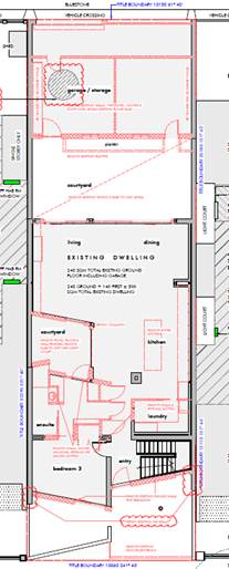
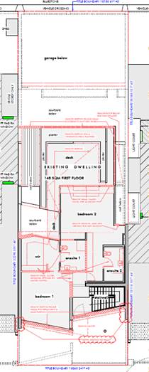
Fig 1(left) – Ground floor demolition plan
(demolition shown red)
Fig 2(right) – First floor demolition plan (demolition shown red)
Proposed works
· The general footprint of the main residential building would largely remain unchanged.
· The ground floor of the residential building generally comprises of family (living), kitchen, dining with light court, pantry, sitting, guest bedroom with WIR and ensuite and laundry.
· The first floor of the residential building generally comprises of a master bedroom and two other bedrooms, all with WIR and ensuite. The footprint of the first floor is increased such that it is similar to the ground floor building footprint.
· The front façade of the residential building is largely renovated with new walls (double height arched window feature) along with opaque ripple glass windows to a height of 1m form FFL and remainder of it being clear glass at the upper level.
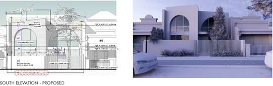
Fig 3 – Front elevation and render
· Similarly, the rear façade of the residential building is also largely renovated with new walls that also has opaque ripple glass windows to a height of 1m form FFL and remainder of it being clear glass at the upper level. The ground floor largely consists of glass façade (windows and doors).
· While a part of existing front fence made of brick at 1.8m high is retained and rendered with ‘Haymes Collette’, a new 1.8m high timber slat fence is proposed replacing the existing iron picket fence.
· A new double storey detached building at the rear part of the lot is proposed to the north-west half comprising of a double garage and gym and sauna at ground and first floor respectively.
· A new plunge pool and lounging deck is proposed to the north-east part of the lot. The pool equipment is proposed along the rear boundary with a planter over.
· A new roof is installed to the extended portion of the main residential building at the rear and for the double storey detached building at the rear of the lot.
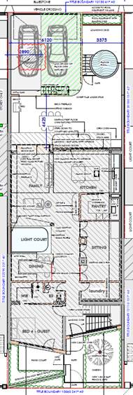
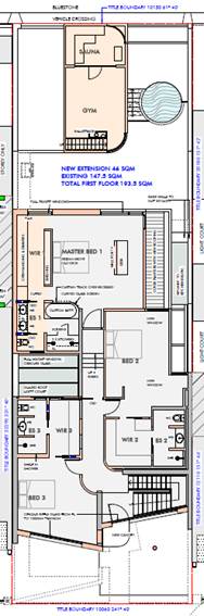
Fig 4(left) – Ground floor proposed plan
Fig 5(right) – First floor proposed plan
6. SUBJECT SITE AND SURROUNDS
6.1 The following is an overview of the subject site and surrounds:
|
|
Description of Site and Surrounds |
|
Site Area |
Site area is approximately 324 sqm. |
|
Existing building and site conditions |
The site is a regular rectangular shaped lot that has a frontage to Greig Street and Little St Vincent Street of 10.06m and a length of 32.29m. The site contains a double storey dwelling fronting Greig Street with large brick garage at the rear accessed by Little St Vincent Street. The ungraded building has a relatively flat and simple semi-contemporary façade with broken pitched roof. The land is relatively flat and there are no easements onsite.
Fig 6 – 10 Greig Street |
|
Surrounds/neighbourhood character |
The surrounding area is residential, with both single and double storey brick/masonry render and tile roofed period-style dwellings. Lot sizes on Greig Street are predominantly less than 300sqm and are rectangular shaped. The majority of the dwelling located to the north of Greig Street and south of St Vincent Street use Little St Vincent Street as a secondary lane to access garages located to the rear of the lots. |
|
Immediate interfaces |
The immediate area contains predominantly Victorian era dwellings with a mix of double storey contemporary dwellings of a similar style and materiality of the subject site. The below images are indicative of the general appearance of dwellings with the immediate area, which have similar bulk and building width, with slight variation as to materials and colours.
There are several double storey detached buildings facing Little St Vincent Lane with similar bulk and scale with varied street setbacks, as seen in the images below.
|
7. Permit Triggers
7.1 The following zone and overlay controls apply to the site, with planning permission required as described.
|
Zone or Overlay |
Why is a permit required? |
|
Clause 43.01 Heritage Overlay (HO442 – Albert Park Residential Precinct) |
Clause 43.01-1 states a permit is required to: · Demolish or remove a building · Construct a building or construct or carry out works · A fence if the fence is visible from a street · Externally paint (noting external paint controls apply) |
8. PLANNING SCHEME PROVISIONS
8.1 The following provisions of the Metropolitan Planning Strategy are relevance to this application:
Clause 02 Metropolitan Planning Strategy
02.01 Context
02.02 Vision
02.03 Strategic Directions
02.04 Strategic Framework Plans
8.2 The following State Planning Policies are relevant to this application:
Clause 11 Settlement
11.01-1R1 Settlement – Metropolitan Melbourne
11.02 Managing Growth
11.03 Planning for Places
Clause 13 Environmental Risks and Amenity
13.01-2S Coastal inundation and erosion
Clause 15 Built Environment and Heritage
15.01-1 Built Environment
15.01-1R Urban Design – Metropolitan Melbourne
15.01-2S Building Design
15.01-5S Neighbourhood Character
15.02-1 Sustainable Development
15.03 Heritage
15.03-1S Heritage Conservation
Clause 16 Housing
16.01 Residential Development
16.01-1S Housing Supply
Clause 19 Infrastructure, including
19.03 Development infrastructure
19.03-3L Stormwater management (water sensitive urban design)
8.3 The following other planning scheme provisions are relevant to this application:
Clause 65 Decision Guidelines
Clause 71 Operation of this Planning Scheme Framework
8.4 There are no planning scheme amendments relevant to this application.
9. REFERRALS
Internal referrals
9.1 The application was referred Council’s Heritage Advisor. They do not object to the proposal who is satisfied with the form, appearance and materiality of the proposal. They have specifically noted in relation to objector concerns regarding the arched windows and ripple glass, that “the current house is ungraded and the form (opposing skillion roofs) and some of the details (irregular fenestration) are not sympathetic to the heritage character of the area, …the proposed alterations and additions comply with Council’s heritage policy, as follows:
· The ‘squaring off’ of the facade to create two, offset parapetted forms is a better response to the parapetted terrace houses found in the street.
· The replacement of the discordant irregular fenestration with single centrally placed windows with a tripartite (three-part division) form also responds to the fenestration pattern in the adjoining houses (single tripartite windows placed centrally in the facade). While arched windows are not seen in this street, they are found in Victorian architecture and the form could be seen as an interpretive response to the arched pediments found on the adjoining terrace houses.
· The ripple glass is a very minor detail, which will have no adverse impacts.
· Other aspects of the materiality, such as the brick cladding and bronze metal details to the windows are sympathetic and respectful and will introduce subtle detail and texture.
· Overall, this is a good contextual contemporary response that will improve the presentation of the building and ensure that it sits more comfortably within the streetscape.
9.2 The application was referred to Council’s Sustainable Design Officer in respect of the Water Sensitive Urban Design measures as required at Clause 19.03-3L. Conditions are required to ensure the STORM report achieves a 100% rating, noting that there is a discrepancy with the number of bedrooms noted in the current report. Subject to this update, the proposal is acceptable.
External referrals
9.3 The application was not required to be referred to any external authority under the provisions of Section 55 of the Planning and Environment Act 1987 or Clause 66 of the Port Phillip Planning Scheme.
10. PUBLIC NOTIFICATION/OBJECTIONS
10.1 The proposal may result in material detriment therefore Council gave notice of the proposal by ordinary mail to the owners and occupiers of surrounding properties (11 letters) and directed that the applicant give notice of the proposal by posting 2 notices on the site for a 17 day period, in accordance with Section 52 of the Planning and Environment Act 1987.
10.2 The application has received 18 objections. The key concerns raised are summarised below:
· Proposed front façade not in keeping with scale, style and materials of the street.
· Additions are overly visible from the public realm.
· Use of non-heritage materials.
· Non-compliance with ResCode setback requirements.
· Detached building rear setback.
· Unreasonable overshadowing.
· Loss of privacy / overlooking.
· Noise levels from pool related use and equipment.
· Poor access to sunlight.
10.3 Notice of the application was also given to Melbourne Water as the site is site is affected by flooding from tidal inundation due to Sea Level Rise for the year 2100. Melbourne Water has “Guidelines for Development in Flood Affected Areas”. The existing dwelling's footprint is not increased by more than 20 square metres and based on the guidelines the dwelling may retain the existing Finished Floor Level. With respect to the proposed garage, the existing garage footprint is being demolished and a new garage being constructed in its place. Under the guidelines the minimum floor level for a new garage is the 1% AEP flood level, that is 2.4 metres to AHD. The garage's current Finished Floor Level at 2.32 metres would not meet the Guidelines. Melbourne Water has not objected to the proposal on the basis that the Finished Floor Level of the garage is increased. Given the requirements at Clause 13.01-2S and the minimal increase in height, this is considered reasonable to condition.
10.4 A consultation meeting was held on 17 December 2024. The meeting was attended by the applicant, owners, objectors, Ward Councillors and Planning Officers. As a result of the meeting, to alleviate concerns with the use of non-heritage materials, the applicant proposes to replace white brick tiles with painted white bricks. This will form a condition of the within the recommendation.
10.5 It is considered that the objectors do not raise any matters of significant social effect under Section 60 (1B) of the Planning and Environment Act 1987.
11. OFFICER’S ASSESSMENT
11.1 A planning permit is required under the provisions of the Heritage Overlay only.
Is the heritage response acceptable?
11.2 The purpose of the Heritage Overlay is to conserve and enhance places of natural or cultural significance, to conserve those elements which contribute to the significance of the place and to ensure that development does not adversely affect the significance of heritage places. This purpose is consistent with the broader heritage conservation objectives of the Planning Policy Framework at Clause 15.03-1S. Clause 15.03-1L provides the principal policy guidance in assessing an application within the heritage overlay.
11.3 An assessment of the proposal against the purpose and decision guidelines of the Heritage Overlay and relevant strategies and guidelines of Clause 15.03-1L - Heritage Policy is provided below. Consideration has also been given to the Heritage Design Guidelines (City of Port Phillip 2022).
Demolition
11.4 Partial demolition is proposed to the ungraded building that predominantly includes removal internal walls and externals walls to the front and rear. This demolition to the existing building that has a simple semi-contemporary façade with little architectural features is considered to be acceptable as they do not bear any heritage significance. The removal of the rear shed is also considered acceptable as it does not contribute to the heritage character of the area.
Dwelling extension
11.5 The majority of the proposed works are to retrofit the existing building, except for minor first floor additions to the area that are largely contained within the ground floor building footprint. The rear additions will not be seen from Greig Street due to the existing double storey dwelling that span from between both common boundaries at both levels.
11.6 The proposed new façade that includes two double height arched window would not unreasonably change the appearance of the dwelling or have a negative impact on the streetscape. The proposed façade would result in a more contemporary looking building which is considered a better outcome than a replica of heritage buildings in the immediate area.
11.7 There are several other contemporary buildings in the immediate area which has similarities to the contemporary design of the proposal.
11.8 The rear additions are also considered acceptable. Little St Vincent Street serves as a service / access road largely being used for accessing the rear garages of dwelling located on Greig Street and St Vincent Street. It has examples of garages with first floor additions. The proposed built form fronting Little St Vincent Street is reflective of the scale and form of this streetscape. It presents an acceptable response from a heritage perspective.
Fencing
11.9 While the existing brick fence is retained and rendered with a colour that is widely noticeable in the immediate area, the proposed replacement of the iron picket fence with a similar 1.8m high timber fence and gate is also considered acceptable. This is due to its natural finish and it being a material that is common within heritage streetscapes.
External painting
11.10 The proposed external materials and colours of the dwelling, particularly that front Greig Street are respectful of the heritage character of the precinct and would not have a negative impact on the streetscape. It is noted that the chosen colours are similar to that of the existing building colour, and with the use of brick tiles, it would not overly standout or be of unwanted attraction.
11.11 However, to alleviate the objector concerns with the use of non-heritage materials, the applicant agreed at the Planning Consultation Meeting to replace ‘white brick tiles’ with ‘brick painted with Lime White’. This would not overly alter the appearance of the dwelling and given that this colour is generally recommended by the Council for Heritage buildings, it is considered acceptable. This forms a condition as part of the recommendation.
Amenity – Clause 54/55 (Rescode)
11.12 Given the site is over 300sqm, a planning permit is not required for the proposed extensions under the Neighbourhood Residential Zone (Clause 32.09). Specifically, Clause 32.09-5 (Construction and extension of one dwelling on a lot). There is no scope to consider amenity impact as part of this assessment. This will be undertaken through the Building Permit process.
Sustainable Design and Water Sensitive Urban Design
11.13 Clause 19.03-3L Stormwater Management (Water Sensitive Urban Design) applies to extensions to existing buildings which are 50sqm in floor area or greater. Noting the proposed increase in floor area exceeds 50sqm, this policy applies.
11.14 The proposal is broadly acceptable with and capable of achieving a STORM rating of 100 per cent. This will form a condition within the recommendation.
12. COVENANTS
12.1 The applicant has completed a restrictive covenant declaration form declaring that there is no restrictive covenant on the titles for the subject site known as Crown Allotment 10 Section 77 City of South Melbourne Parish of Melbourne South [Parent Title Volume 01245 Folio 952].
13. OFFICER MATERIAL OR GENERAL INTEREST
13.1 No officer involved in the preparation of this report has declared a material or general interest in the matter.
14. CONCLUSION
14.1 The proposed demolition is considered appropriate as they are not considered to affect the ungraded building. In addition, Council’s Heritage Advisor is supportive of the proposed demolition and buildings and works as outlined throughout this report.
14.2 The general footprint of the proposed extension is considered respectful of the original building through a design response that does not seek to overlay alter the original building, nor is it considered to dominate the streetscape.
14.3 The scale of the proposed extension is such that it maintains the original building height and therefore does not have any additional visual impact on the immediate area.
14.4 Approval is recommended subject to conditions
|
ATTACHMENTS |
1. 10 Greig Street Albert Park - RFI Plans |
Planning Committee
26 February 2025
|
Statutory Planning Delegated Decisions Report (12 December 2024 until the first sitting of the Ordinary Council meeting in 2025) |
|
|
location/address: |
Whole municipality |
|
Executive Member: |
Brian Tee, General Manager, City Growth and Development |
|
PREPARED BY: |
Paul Wood, Manager City Development |
1. PURPOSE
1.1 To present a summary of planning decisions made by the Chief Executive Officer over the summer holiday period between 12 December 2024 and the first sitting of the Ordinary Council meeting in 2025, as authorised by delegation at the Ordinary Council Meeting on 11 December 2024.
2. EXECUTIVE SUMMARY
2.1 Over the summer holiday period, the Chief Executive Officer was provided delegation from Council to make certain planning decisions to ensure processes were not unreasonably delayed until the first sitting of the Ordinary Council Meeting or Planning Committee Meeting in 2025.
2.2 This report provides a summary of the one planning decision made during this period.
|
That Council: 3.1 Notes the one decision made by the Chief Executive Officer under delegation from Council for the period between 12 December 2024 and 5 February 2025, being the period between last Ordinary Council Meeting in 2024 and the first sitting of the Ordinary Council Meeting in 2025. |
4. KEY POINTS/ISSUES
4.1 At the Ordinary Council Meeting on 11 December 2024, Council resolved to delegate to the Chief Executive Officer, the power to determine certain planning matters that are otherwise decided by Council at an Ordinary Council Meeting or Planning Committee Meeting.
4.2 The purpose for this was to ensure certain planning processes that required decisions to be made by Council during this period occurred, to limit risk to Council.
4.3 The resolution requires that all decisions made under this delegated framework be reported to an Ordinary Council Meeting or Planning Committee Meeting before the end of March 2025.
4.4 The following is the one decision made under this delegated framework:
PDPL/00403/2024 - 219-221 Park Street, South Melbourne
4.4.1 An appeal was lodged against Council’s failure to determine an application within the statutory timeframe.
4.4.2 The proposal is for demolition of the non-contributory building and the construction of a five-storey mixed use building over two basement levels comprising retail and office (as-of-right); the use of the land for dwellings with a ground floor frontage exceeding 2 metres in width; and a reduction in the number of car parking spaces required under Clause 52.06-5 for retail.
4.4.3 The matter was listed for a Compulsory Conference on 30 January 2025, which was before the sitting of the first Council Meeting. Council was required to have a resolved position for the VCAT process.
4.4.4 Council decided under this delegation, that had it been in a position to determine that application, it would have supported the proposal subject to a conditions. This now forms the position that Council will advance as part of the VCAT process.
4.4.5 It is noted that VCAT is the decision maker for this application.
4.4.6 Council received 46 objections to the proposal before the appeal was lodged. All objectors were given the opportunity to join as a party to the VCAT appeal. Many of the objectors are now parties to the appeal and will defend their own positions.
4.4.7 The proposal was considered to represent an acceptable planning outcome, having regard to the site context, relevant planning policy framework and with respect to a previous VCAT decision which refused a development on the land.
4.4.8 The previous VCAT decision provided direction about what would be acceptable and Council was required to give weight to this decision is forming its position on the current VCAT matter.
4.4.9 This matter did not settle at the Compulsory Conference and is listed for a full hearing between 7 and 11 April 2025.
5. OFFICER material OR general INTEREST
5.1 No officers involved in the preparation of this report has declared a material or general interest in the matter.
|
ATTACHMENTS |
Nil |
7. Urgent Business
8. Confidential Matters
Nil