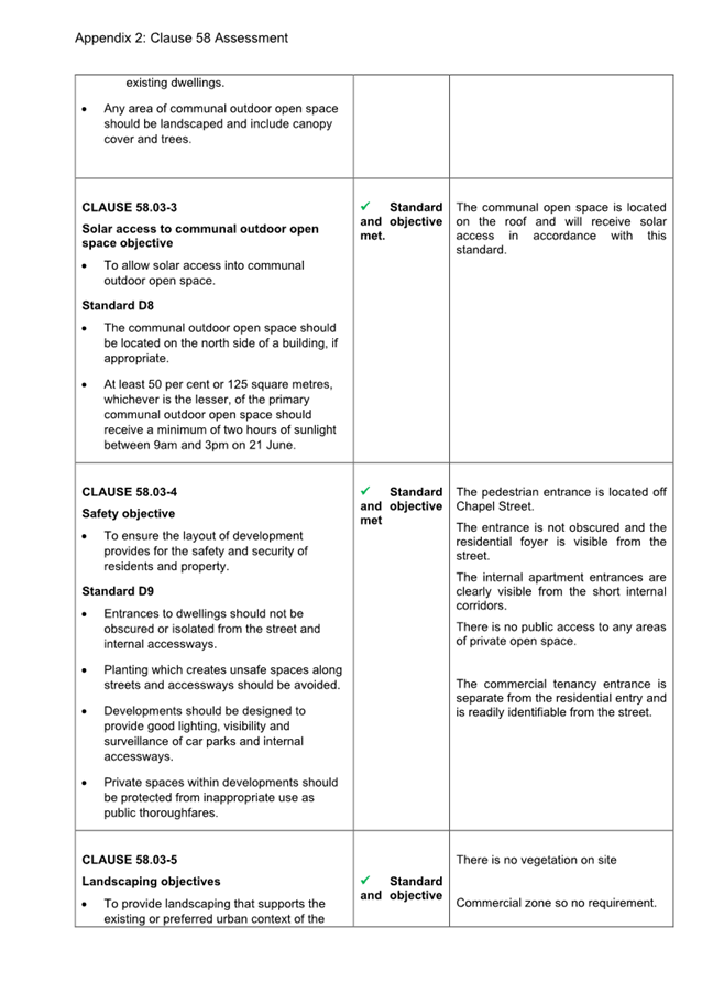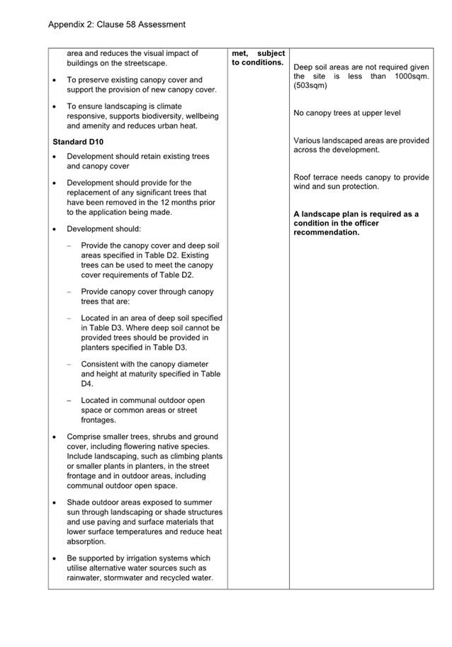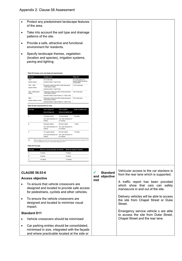
Planning Committee
23 July 2025
|
Welcome Welcome to this Planning Committee Meeting of the Port Phillip City Council. The aim of this Committee is to consider, within the framework of the Planning and Environment Act, State and Local Planning Schemes, major planning applications or applications that will have a large impact on the local area. This Committee also allows you to be involved in the statutory and strategic planning decision making processes of Council.
About this meeting There are a few things to know about tonight’s meeting. The first page of tonight’s Agenda itemises all the different parts to the meeting. Some of the items are administrative and are required by law. In the agenda you will also find a list of all the items to be discussed this evening. Each item has a report written by a Council officer outlining the purpose of the report, all relevant information and a recommendation. The Committee will consider the report and either accept the recommendation or make amendments to it. This Committee has delegated authority. A recommendation is carried if it receives majority support of the Councillors in attendance at the Committee meeting. |
Public Question Time and Submissions Public Question Time Provision is made at the beginning of the meeting for general question time from members of the public concerning planning matters. All contributions from the public will be heard at the start of the meeting during the agenda item 'Public Questions and Submissions.' Members of the public have the option to either participate in person or join the meeting virtually via Teams to ask their questions live during the meeting. If you would like to address the Council and /or ask a question on any of the items being discussed, please submit a ‘Request to Speak form’ by 4pm on the day of the meeting via Council’s website: Request to speak at a Council meeting - City of Port Phillip
|
|
|
|
|
PORT PHILLIP CITY COUNCIL Planning Committee |
To Councillors
Notice is hereby given that a Planning Committee Meeting of the Port Phillip City Council will be held in St Kilda Town Hall and virtually via Teams on Wednesday, 23 July 2025 at 6:30pm. At their discretion, Councillors may suspend the meeting for short breaks as required.
AGENDA
1 APOLOGIES
2 MINUTES OF PREVIOUS MEETINGS
Minutes of the Planning Committee 23 April 2025.
3 Declarations of Conflicts of Interest
4 Public Question Time and Submissions
5 Councillor Question Time
6 Presentation of Reports
6.1 80 Wright Street, Middle Park - PDPL/00281/2025............................................ 5
6.2 145 Chapel Street, St Kilda - PDPL/00195/2024.............................................. 42
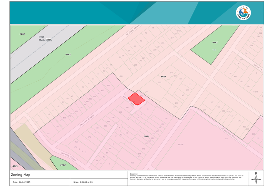
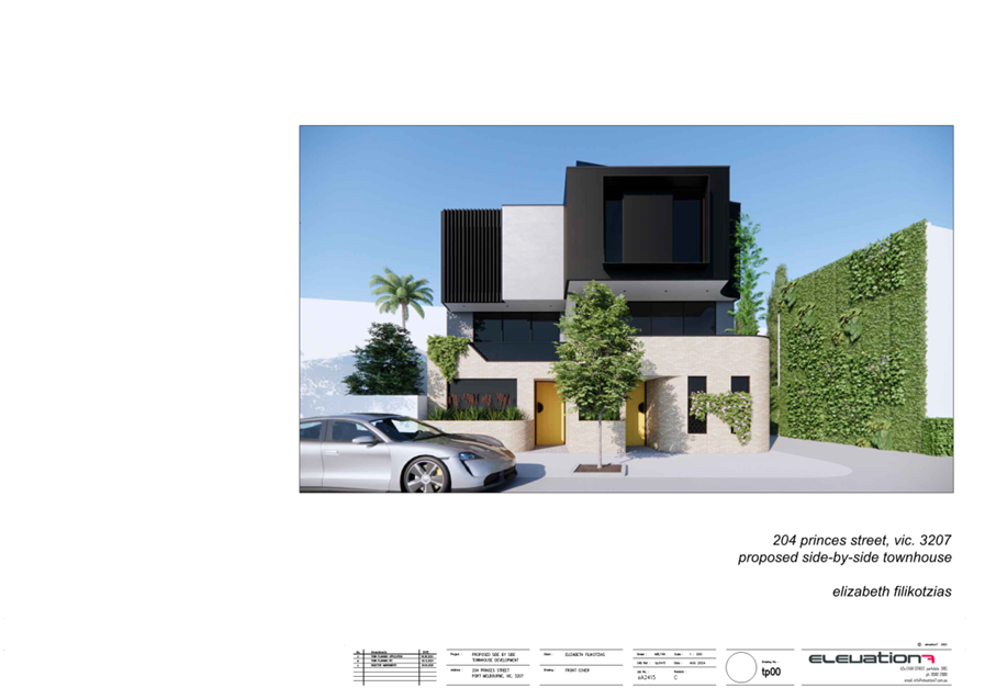
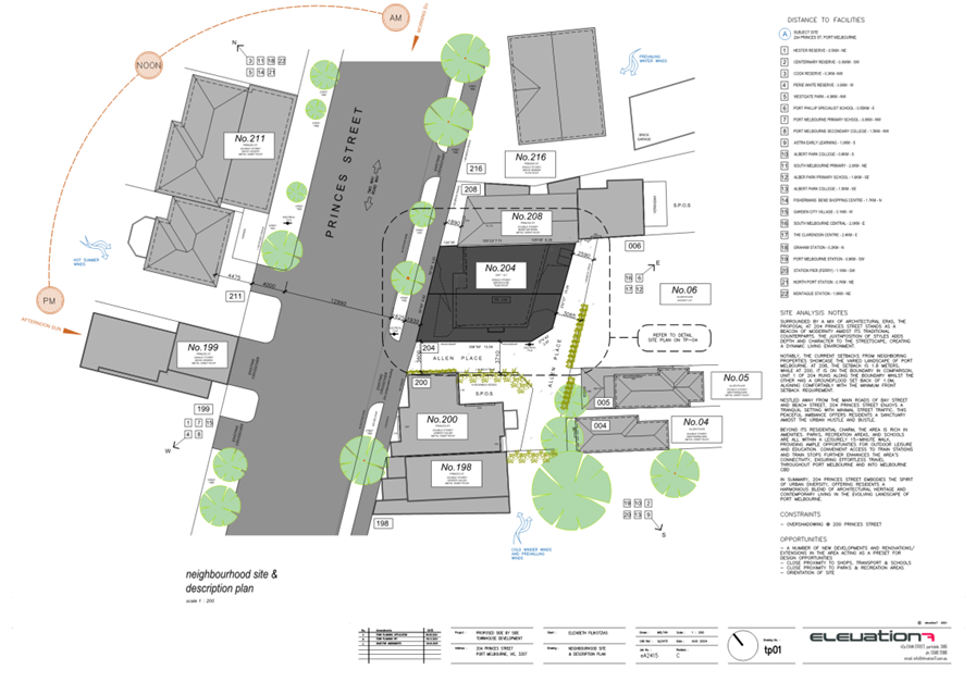
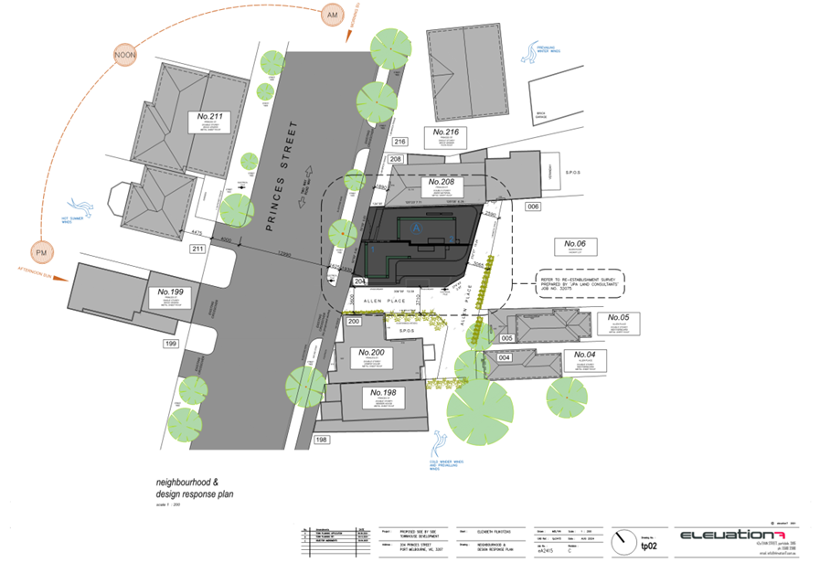
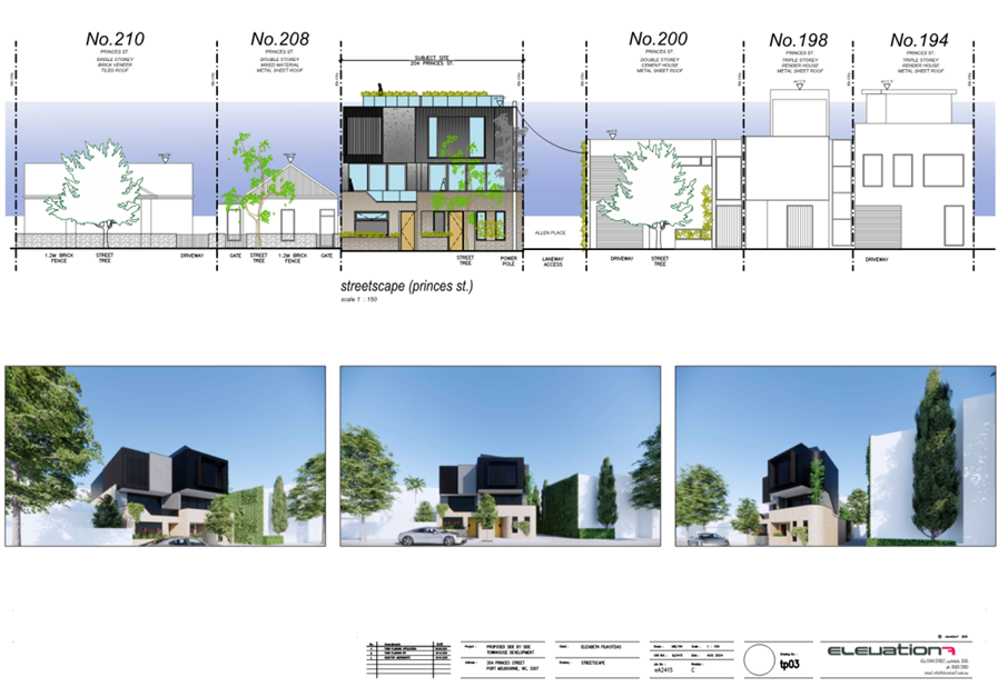
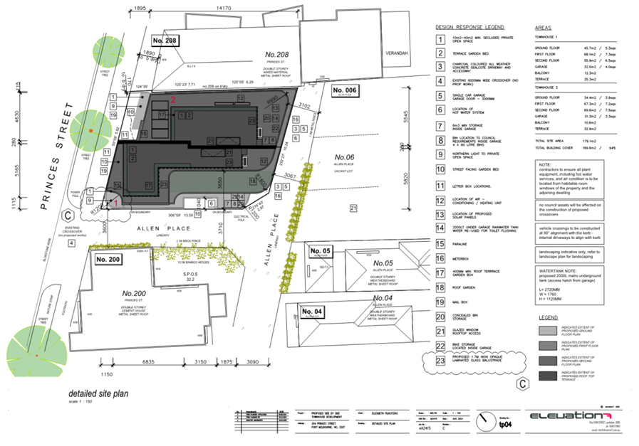
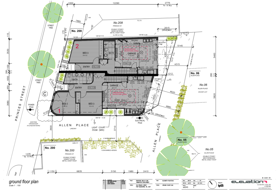
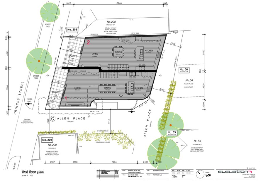
6.3 204 Princes Street, Port Melbourne - PDPL/00535/2024............................... 120
7 URGENT BUSINESS
8 Confidential Matters
Nil
1. Apologies
2. Minutes of Previous Meetings
|
That the minutes of the Planning Committee of the Port Phillip City Council held on 23 April 2025 be confirmed. |
3. Declarations of Conflicts of Interest
4. Public Question Time and Submissions
5. Councillor Question Time
6.1 80 Wright Street, Middle Park - PDPL/00281/2025............................................ 5
6.2 145 Chapel Street, St Kilda - PDPL/00195/2024.............................................. 42
6.3 204 Princes Street, Port Melbourne - PDPL/00535/2024............................... 120
Planning Committee
23 July 2025
|
6.1 |
80 Wright Street, Middle Park - PDPL/00281/2025 |
|
location/address: |
80 Wright Street, Middle Park |
|
Executive Member: |
Brian Tee, General Manager, City Growth and Development |
|
MANAGER |
PAUL WOOD, MANAGER CITY DEVELOPMENT |
|
PREPARED BY: |
James McInnes, Principal Planner |
1. PURPOSE
1.1 To consider and determine planning application PDPL/00281/2025 for the demolition of an existing dwelling, and construction of a two-storey dwelling in a Heritage Overlay.
2. EXECUTIVE SUMMARY
|
Ward: |
Albert Park |
|
Trigger for
determination |
More than 16 objections |
|
ApplicATION NO: |
PDPL/00281/2025 |
|
Applicant: |
Roda Developments |
|
Existing use: |
Dwelling |
|
Abutting uses: |
Dwellings, primary school, and place of worship |
|
Zoning: |
Neighbourhood Residential Zone, Schedule 1 (NRZ1) |
|
Overlays: |
Heritage Overlay (HO444) |
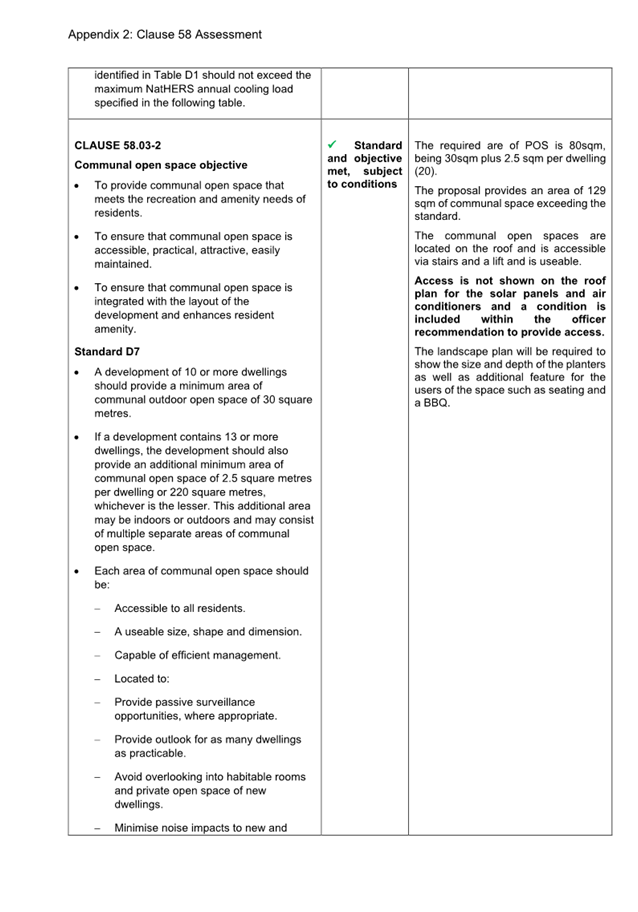
2.1 This report provides Council with an assessment of planning application PDPL/00281/2025 at 80 Wright Street, Middle Park. The key considerations are the acceptability of the demolition of the existing non-contributory dwelling, and whether the proposed replacement dwelling is acceptable within the context of the Heritage Overlay.
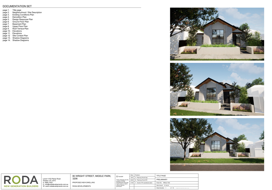
2.2 The application proposes the full demolition of the existing dwelling and associated outbuildings and fencing on the site. In its place, and the construction of a two-storey replacement dwelling to a maximum height of 7.26 metres is proposed.
2.3 The land is within the Neighbourhood Residential Zone, Schedule 1 (NRZ1), and is affected by a Heritage Overlay 444 – Middle Park and St Kilda West Precinct (HO444). As the subject site is larger than 300 square metres in area, there are no planning requirements under the zone, meaning there is no requirement to consider Clause 54 siting requirements or car parking design as part of this assessment. A planning permit is only required under the Heritage Overlay, and assessment of the proposal is limited to heritage matters.
2.4 The application was publicly notified and received objections from 18 people. Concerns relate to a poor response to the heritage context, impact on the streetscape and surrounding heritage significance, inappropriate bulk, form, and appearance, visibility of upper floor elements, inappropriate external materiality and colour selection, overlooking issues, excessive site coverage, noise impacts from use of the roof terrace and location of air conditioners and pool equipment. Also, that approval would set an inappropriate precedent.
2.5 A consultation meeting was held on 14 April 2025 in response to the previously submitted application at the site, also for a replacement single dwelling. The meeting was attended by an elected member of Council, a Council planning officer, a representative of the permit applicant, and members of the public who made submissions on the application. The meeting resulted in a number of changes to the proposal, namely the ‘splitting’ of the first floor to separate and reduce the overall first-floor footprint. Those changes are included in the plans forming part of the current application subject to this assessment
2.6 The application has been assessed against local and State heritage planning policies contained within the Port Phillip Planning Scheme, and the purpose and decision guidelines of the Heritage Overlay.
2.7 On balance, in meeting the recommended conditions, the proposal is an appropriate design response for the heritage context, and will not adversely affect the significance of nearby heritage places.
2.8 The proposal is recommended for approval, subject to the conditions below.
|
3.1 That the Responsible Authority, having caused the application to be advertised and having received and noted the objections, issue a Notice of Decision to Grant a Permit for Application No. PDPL/00281/2025 at 80 Wright Street, Middle Park. 3.2 That a Notice of Decision to Grant a Permit be issued subject to the following permissions:
3.3 That the decision be issued subject to the following conditions: Approved and endorsed plans 1. The plans endorsed and which form part of this permit are the plans submitted with the application, identified as Sheets 3 to 11 (of 14) inclusive, revision C – dated 21 May 2025, and prepared by Roda Developments. Layout not to be altered 2. The layout of the development must not be altered from the layout on the approved and endorsed plans (unless the Port Phillip Planning Scheme specifies a permit is not required) without the written consent of the responsible authority. Water sensitive urban design 3. Concurrent with the endorsement of plans as required by condition 1 of this permit, the Water Sensitive Urban Design (WSUD) Report, dated February 2025, and prepared by Energy Lab, is endorsed to form part of this permit. 4. Before the development is occupied, the provisions, recommendations, and requirements of the endorsed WSUD Report must be implemented and complied with to the satisfaction of the responsible authority. Vehicle crossing 5. Before the development is occupied, the vehicle crossing must be constructed in accordance with Council’s current Vehicle Crossing Guidelines and standard drawings to the satisfaction of the responsible authority. Boundary walls 6. Before the development is occupied, all new or extended walls on or facing the boundaries of adjoining properties or a laneway must be cleaned and finished to the satisfaction of the responsible authority. Equipment or services 7. No plant, equipment or domestic services (including any associated screening devices) or architectural features, other than those shown on the endorsed plans, are permitted, except where they would not be visible from a street (other than a lane) or public park without the written consent of the responsible authority. Gas connection not permitted 8. Any new dwelling allowed by this permit must not be connected to a reticulated gas service (within the meaning of clause 53.03 of the relevant planning scheme). This condition continues to have force and effect after the development authorised by this permit has been completed. Permit expiry 9. This permit as it relates to development (buildings and works, including demolition) will expire if one of the following circumstances applies: a) The development is not started within 2 years of the issued date of this permit. b) The development is not completed within 4 years of the issued date of this permit. In accordance with section 69 of the Planning and Environment Act 1987, an application may be submitted to the responsible authority for an extension of the periods referred to in this condition. |
4. RELEVANT BACKGROUND
Planning permit PDPL/00073/2023
4.1 Planning permit PDPL/00073/2023 was issued by Council on 6 August 2024, approving the partial removal of two easements under Clause 52.02 of the Port Phillip Planning Scheme.
4.2 The easements approved to be removed are E-1 and E-2 as shown on the title plan. These easements are in favour of South East Water Corporation and Melbourne Water. It is noted that they currently extend to be within the proposed building footprint of the garage. There may be a requirement for a build-over-easement agreement between the permit-holder and these authorities, however, this is of no consequence for the approval sought as part of this planning application.
Planning application PDPL/00069/2023
4.3 Planning application PDPL/00069/2023 was lodged with Council on 15 February 2023, proposing full demolition of the existing dwelling and associated outbuildings, and the construction to two double-storey dwellings on the site. The application was refused under delegation by Council on 28 October 2024 on grounds relating to not satisfying heritage and neighbourhood character policy, failing to meet Clause 55 objectives, and car parking design issues.
Planning application PDPL/00009/2025
4.4 Planning application PDPL/00009/2025 was lodged with Council on 13 January 2025, and proposed full demolition of the existing dwelling and associate outbuildings, and construction of a two-storey replacement dwelling. The application was publicly notified and received objections from 23 people.
4.5 Following public notification, Council officers identified that the application had been lodged without a Metropolitan Planning Levy (MPL) certificate, meaning that the application was void and could not be further considered. The application was subsequently withdrawn as being void.
4.6 Planning application PDPL/00281/2025, the application which is the subject of this report, was lodged with Council on 4 June 2024 on the basis of an amended set of plans and with a reduced estimated cost of development, meaning an MPL certificate is not required.
4.7 All objectors to the previous application have been notified of the current application and provided the opportunity to carry over their objection to the current application. In addition to this, standard public notification has been carried out for the current application.
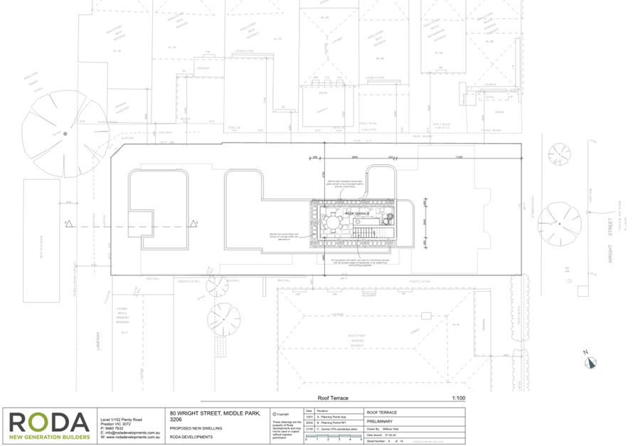
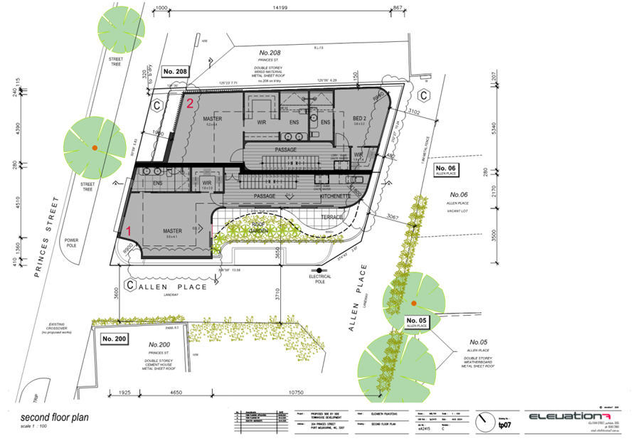
5. PROPOSAL
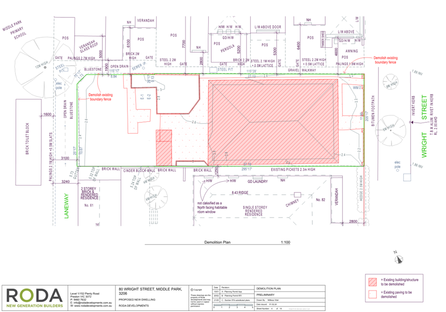
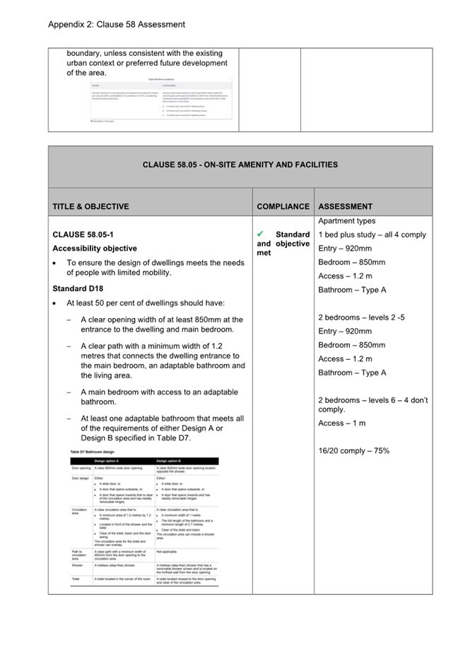
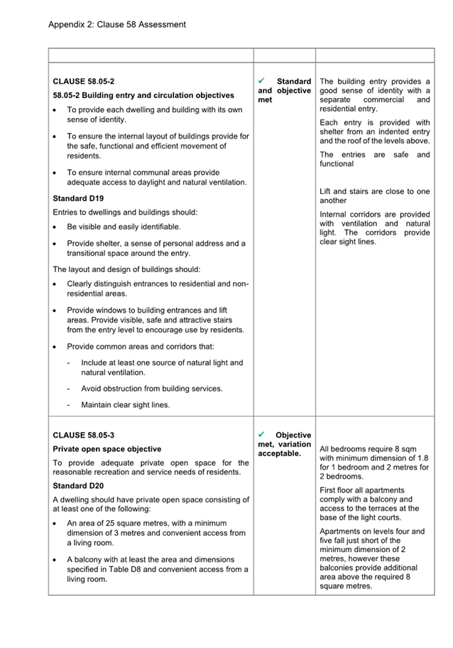
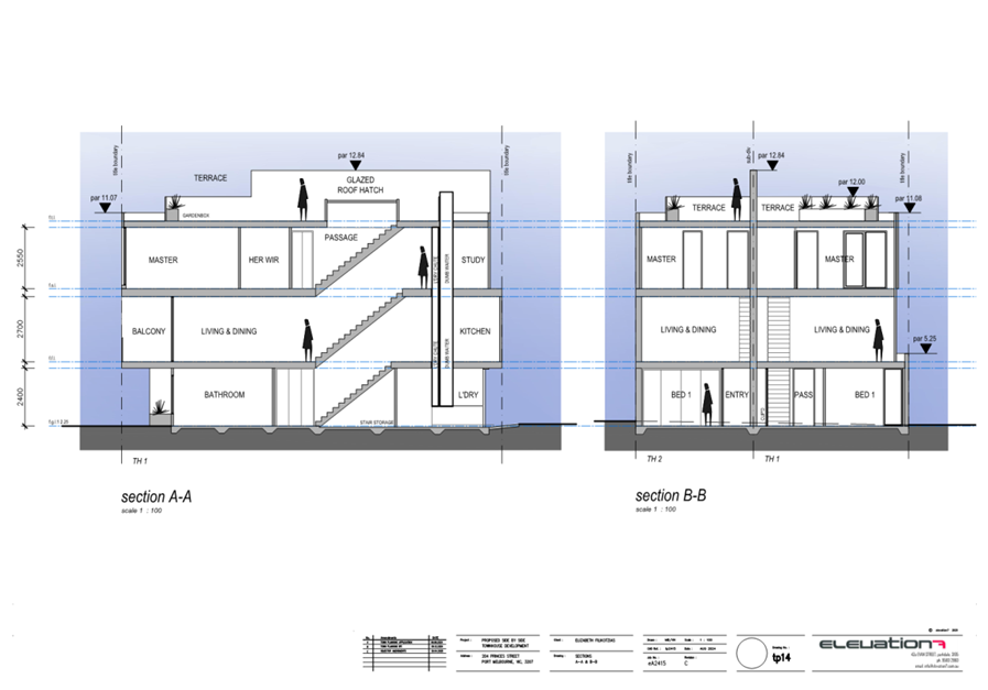
5.1 The application proposes the full demolition of the existing dwelling and associated outbuildings and fences on the site. A two-story replacement dwelling is proposed, consisting of the following:
· A basement level containing a foyer, multi-purpose room, store, and cellar.
· At ground floor an open plan entry/study, master bedroom with ensuite, open plan kitchen/dining/living, store, powder room, laundry, mudroom, alfresco area, and double garage. A pool is proposed within the private open space area to the north-east of the dwelling, however this itself does not require planning permission as it would not be visible from Wright Street or any other street or public park.
· At first floor closest to Wright Stret, two bedrooms, a retreat, nook and bathroom. At first floor closest the rear of the site, a bedroom with ensuite and a balcony.
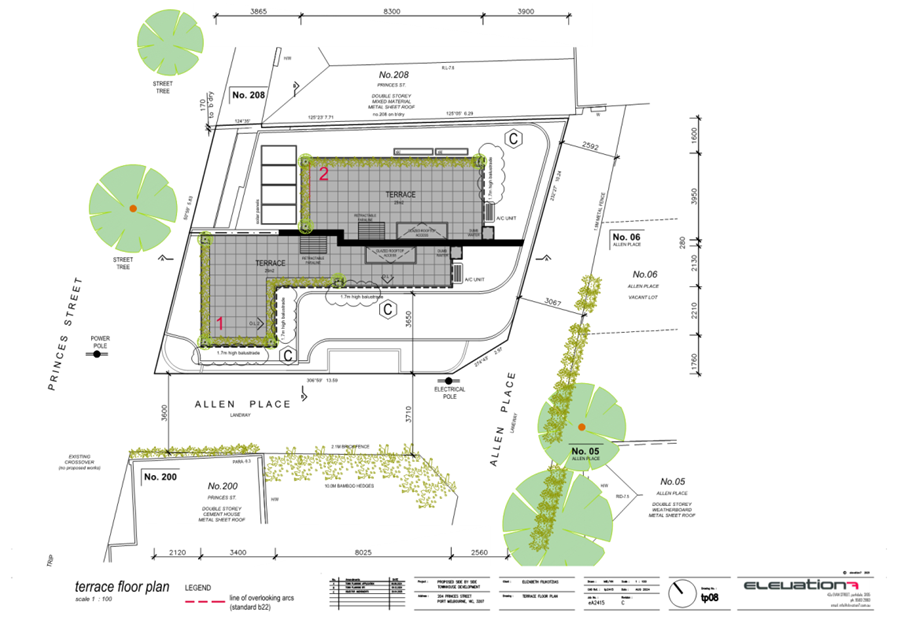
· An uncovered roof terrace immediately above the first-floor retreat.
· A double garage at the rear of the site, with vehicle access to the rear laneway.
· The maximum building height is 7.26 metres. Two boundary walls are proposed to the south-western boundary, and one boundary wall to the north-eastern boundary.
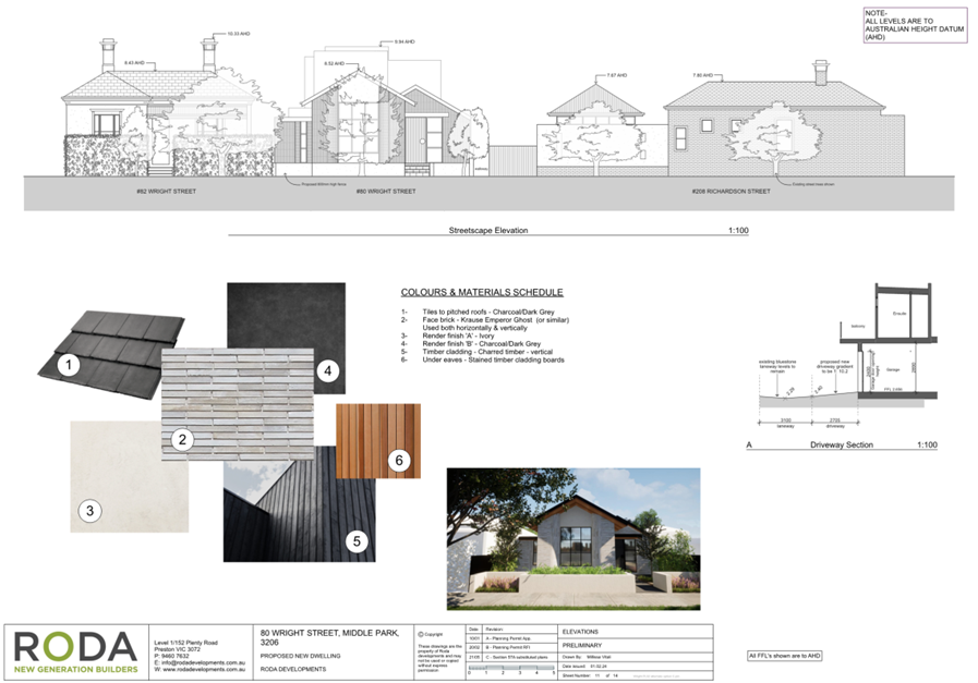
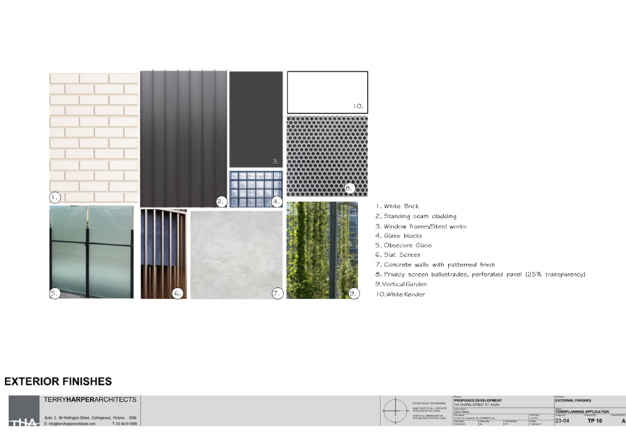
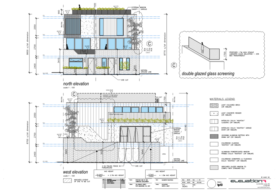
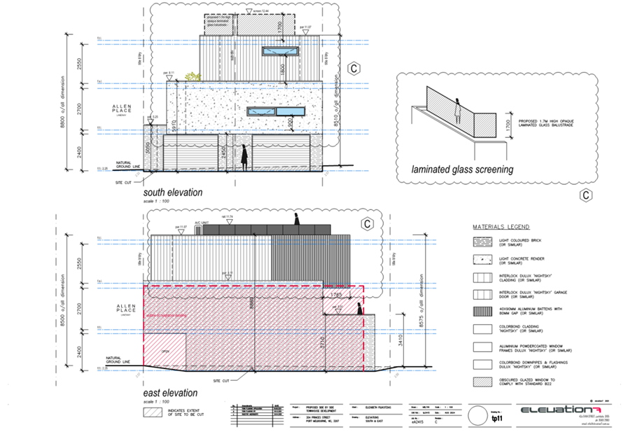
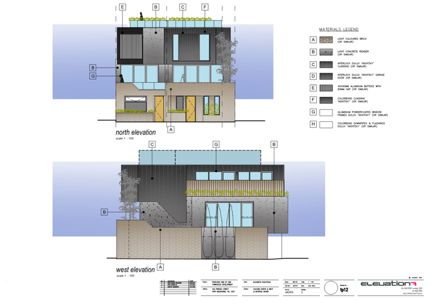
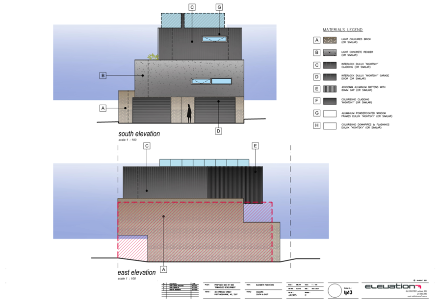
· External materiality is a mix of light-coloured face brick, charred timber cladding, ivory and charcoal/dark grey render, and stained timber cladding. The roof is proposed to be charcoal/dark grey tiling.
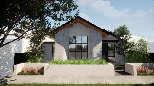
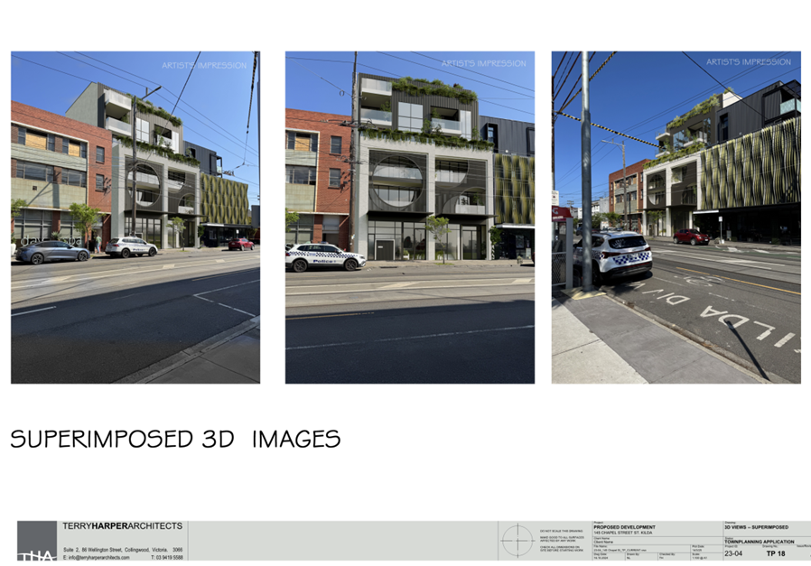
Figure 1 - Artist's rendering of proposal as viewed from Wright Street
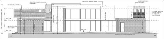
Figure 2 - Excerpt from proposed north-east elevation
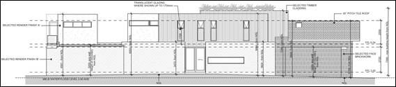
Figure 3 - Excerpt from proposed south-west elevation
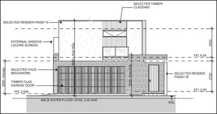
Figure 4 - Excerpt from proposed north-west elevation
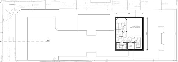
Figure 5 - Excerpt from basement floor plan
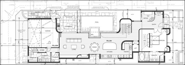
Figure 6 - Excerpt from ground floor plan
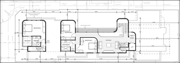
Figure 7 - Excerpt from first floor plan
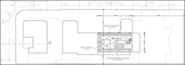
Figure 8 - Excerpt from roof terrace floor plan
6. SUBJECT SITE AND SURROUNDS
The subject site
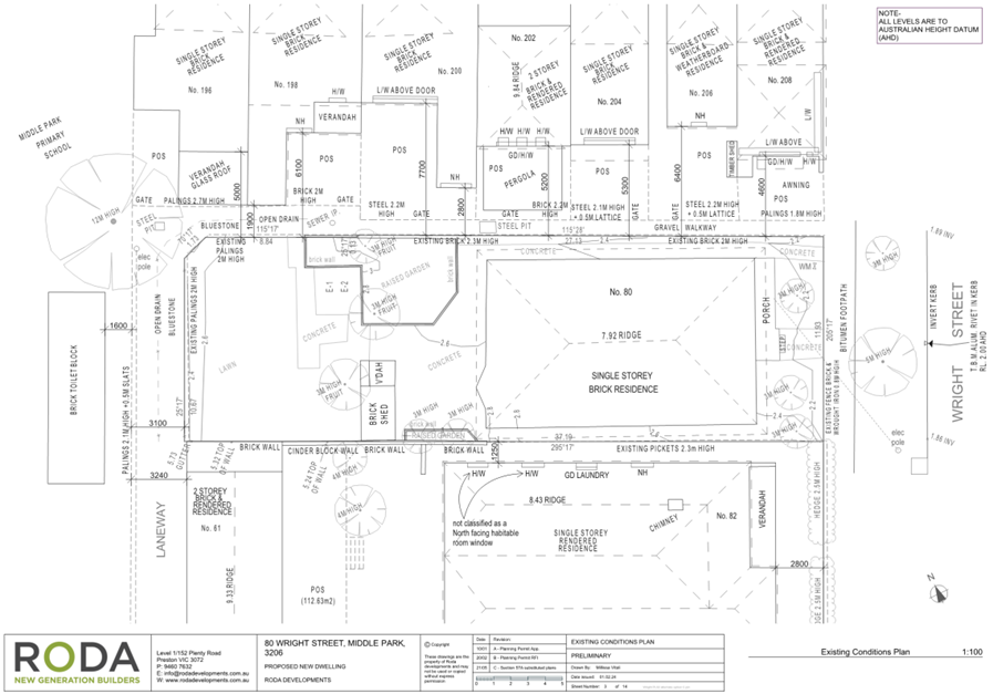
6.1 The subject site is a generally rectangular shaped allotment with a small splay at the north-western corner, is approximately 445 square metres in area, and has a slight rise at the western end of the site. The site fronts Wright Street to the south-east for a width of 11.93 metres, and is 37.19 metres long at its deepest point. The site is bounded partly by a walkway and partly by a laneway along the northern-eastern boundary, by a laneway along the north-western boundary, and by 82 Wright Street along the southern boundary.
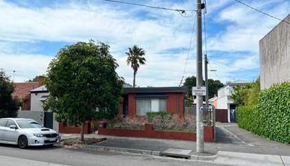
6.2 The site is developed with a single-storey post-war era dwelling, constructed predominately of brick. There is a small brick outbuilding to the rear of the dwelling, together with raised garden beds and concreted areas. There is a 0.8 metre high, brick and wrought iron fence front fence along the street alignment.
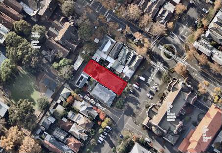
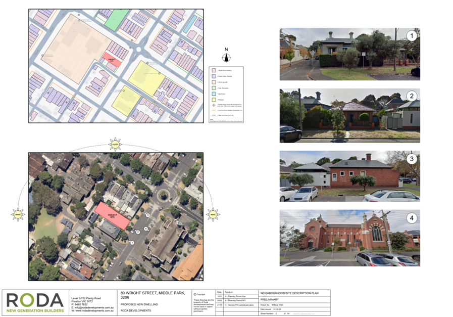
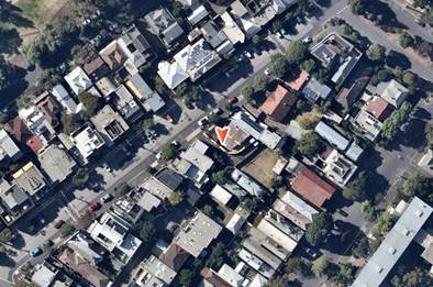
Figure 9 - Aerial image of subject site and surrounding area (NearMap - 26 May 2025)
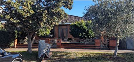
Figure 10 - Photo of subject site frontage (Officer inspection - 4 July 2025)
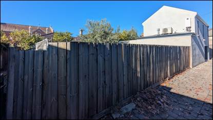
Figure 11 - Photo of rear of subject site, interface with laneway (Officer inspection - 4 July 2025)
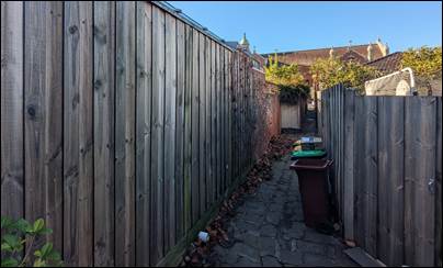
Figure 12 - Photo of subject site north-eastern interface (Officer inspection - 4 July 2025)
The surrounding area
6.3 The surrounding area is predominately zoned Neighbourhood Residential Zone (NRZ), excepting for Middle Park Primary School adjacent to the north-west which is zoned Public Use Zone 2 (PUZ2).
6.4 All immediately adjoining land is within a Heritage Overlay, with surrounding residential areas within the ‘Middle Park and St Kilda West Precinct’ under HO444, Middle Park Primary School individually listed under HO239, and Our Lady of Mt Carmel Catholic Church individually listed under HO238.
6.5 Wright Street road reserve, directly adjoining to the south-east, is a Council-owned road.
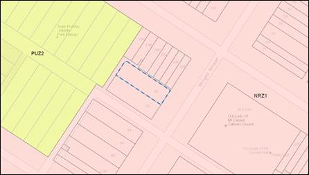
Figure 13 - Map showing zoning of site and surrounding area (VicPlan - 3 July 2025)
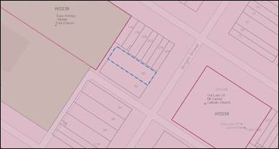
Figure 14 - Map showing extent of Heritage Overlay affecting the surrounding area (VicPlan - 3 July 2025)
6.6 Adjoining and adjacent land is developed as follows:
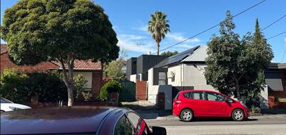
82 Wright Street (adjoining to south-west)
Single-storey, double-fronted Federation-era dwelling, constructed of rendered masonry, with a slate tile double-hipped roof, and a contemporary detached rear two-storey addition. This dwelling has a significant heritage grading.
194 Richardson Street (adjacent to north-west, across laneway)
Middle Park Primary School, which consists of several larger buildings, outbuildings, and open space playground areas. The site has a significant heritage grading.
196 Richardson Street (adjacent to north-east, across laneway)
Single storey Victorian-era dwelling, with a contemporary ground floor extension to the rear. The site has a contributory heritage grading.
196, 198, 200, 202, 204, 206, and 208 Richardson Street (adjacent to north-east, across laneway/pedestrian footpath)
These lots are each developed with single storey Victorian-era dwellings. Each appear to have contemporary ground floor extensions to the rear with 202 Richardson Street subject to a two-storey rear extension. These dwellings all have a significant heritage grading.
210-218 Richardson Street (opposite to south-east, across Wright Street road reserve)
Our Lady of Mt Carmel Catholic Church, which is a large church building constructed of red brick, with high tiled roof form and turrets. This building has a significant grading.
6.7 The broader surrounding area is typified by generally single storey dwellings, however some examples of two and three storey infill development is present (including 39 Harold Street and 92 Hambleton Street), as well as two-storey rear extensions (including 82 Wright Street, 84 Wright Street, 90 Wright Street, 202 Richardson Street, 232 Richardson Street, 234 Richardson Street, and 81 Neville Street).
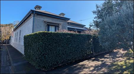
Figure 15 - Photo of 82 Wright Street frontage (Officer inspection - 4 July 2025)
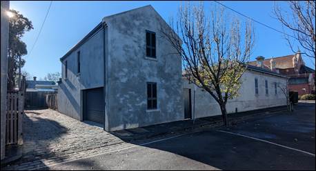
Figure 16 - Photo of 82 Wright Street interface with Neville Street (Officer inspection - 4 July 2025)
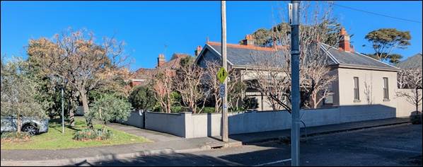
Figure 17 - Photo looking south-east toward 84, 86, and 88 Wright Street (Officer inspection 4 July 2025)
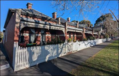
Figure 18 - Photo of 198 (background) to 208 (foreground) Richardson Street frontages (Officer inspection - 4 July 2025)
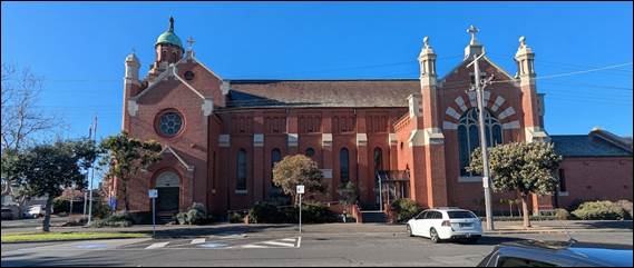
Figure 19 - Photo of Our Lady of Mt Carmel Catholic Church frontage to Wright Street (Officer inspection - 4 July 2025)
7. Permit Triggers
7.1 The following zones, overlays, and particular provisions apply to the site and are relevant to assessment of the proposal. Planning permission is required as described below:
|
Planning control |
Why is a permit required? |
|
Clause 32.09 Neighbourhood Residential Zone, Schedule 1 (NRZ1) |
Use A permit is not required to use the land for the purpose of a dwelling. Buildings and works A permit is not required to construct or extend one dwelling on a lot greater than 300 square metres in area. Minimum garden area requirement Clause 32.09-4 of the NRZ requires 30% of a lot between 500-650 square metres be set aside as garden area. The application meets this requirement, setting aside approximately 34% (152.68 square metres). |
|
Clause 43.01 Heritage Overlay (‘Middle Park and St Kilda West Precinct’ – HO444) |
Buildings and works A permit is required to demolish or remove a building. A permit is required to construct a building or construct or carry out works. |
|
Clause 52.06 Car Parking |
Clause 52.06 does not apply to the construction and use of one dwelling on a lot in the Neighbourhood Residential Zone, unless the zone or a schedule to the zone specifies that a permit is required to construct one dwelling on a lot. |
|
Clause 53.03 Residential Reticulated Gas Service Connection |
Clause 53.03 applies to an application for a permit for the construction of a new dwelling. The mandatory condition at Clause 53.03-2 prohibiting any new dwelling allowed by a planning permit must be included on any permit issued for the proposal. |
8. PLANNING SCHEME PROVISIONS
8.1 The following policies, controls, and provisions are relevant to assessment of this application:
Municipal Planning Strategy (MPS) and Planning Policy Framework (PPF)
· Clause 02 – Municipal Planning Strategy
o Clause 02.01 – Context
o Clause 02.02 – Vision
o Clause 02.03 – Strategic Directions
· Clause 15 – Built Environment and Heritage
o Clause 15.03 – Heritage
§ Clause 15.03-1S – Heritage conservation
§ Clause 15.03-1L – Heritage policy
· Clause 19 - Infrastructure
o Clause 19.03 – Development Infrastructure
§ Clause 19.03-3L Stormwater management (water sensitive urban design)
Zone and Overlay Controls
· Clause 43.01 – Heritage Overlay
Particular, General, and Operational Provisions
· Clause 53.03 – Residential Reticulated Gas Service Connection
· Clause 65 – Decision Guidelines
· Clause 71.02-3 – Integrated decision making
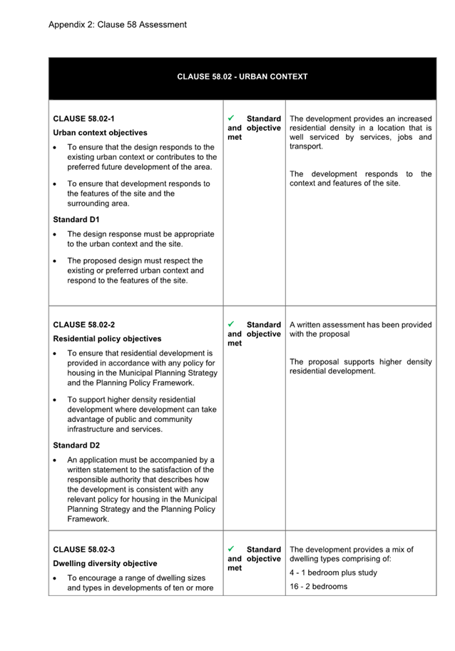
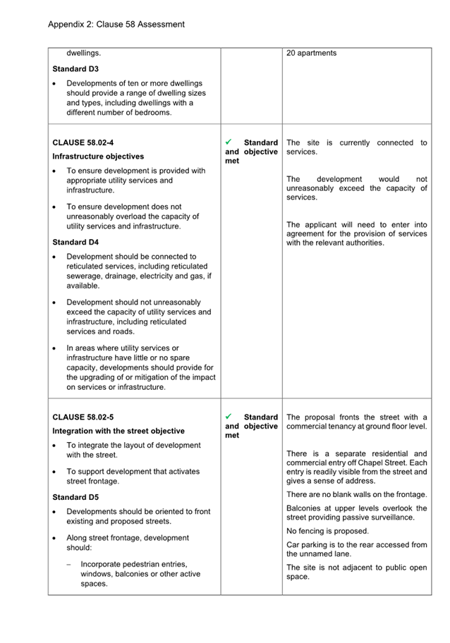
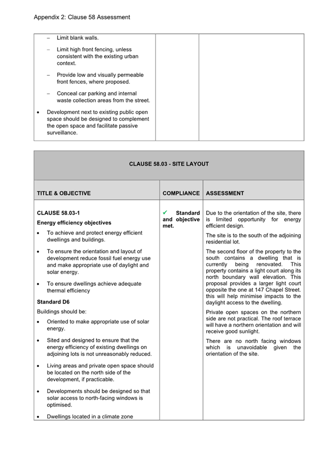
8.2 The subject site is within the Middle Park and St Kilda West Precinct (HO444) of the Heritage Overlay. The statement of significance for the precinct is summarised below:
What is significant?
The Middle Park/St Kilda West Precinct comprises a large wedged-shaped area bounded by the major thoroughfares of Canterbury Road, Fitzroy Street, Beaconsfield Parade(one of Melbourne’s premier beachside boulevards) and Kerferd Road. Owing to the swampy land, residential development was delayed – commencing at the south-eastern (St Kilda West end) in the early 1870s, spreading along the north-western fringe (Kerferd Road, Canterbury Road and the top ends of intersecting side streets) from the late 1870s to the 1890s and then finally infilling during the early 1900s and 1910s. Today, the precinct remains strongly characterised by a broad range of late Victorian and Edwardian housing stock, with contemporaneous commercial and community-oriented buildings (corner shops, churches, schools and hotels).
Why is it significant?
Historically, the precinct is significant as a notable and highly atypical expanse of late nineteenth and early twentieth century inner-suburban residential development, conspicuously sandwiched between the much older settlements of Port Melbourne (Sandridge), South Melbourne (Emerald Hill) and St Kilda. With the contemporaneous development of Middle Park and St Kilda West hampered by a notorious expanse of swampland and a foreshore military reserve, it was not until the late 1870s and early 1880s – when the swamp was reclaimed, military presence was withdrawn and the new Middle Park Railway Station was opened (1882) – that residential expansion could begin in earnest.
……
Aesthetically, the precinct is significant for its fine and largely intact streetscapes of Victorian and Edwardian housing.
……
Irrespective of their style and era, the pre-war buildings within the precinct exhibit notable cohesion through their broadly consistent scale (mostly one and two storey) and materials, their closely grained siting and relatively narrow setbacks. Many of the streetscapes are enhanced by their settings, which includes original bluestone kerbs, gutters and pitching to laneways and crossovers (particularly along Kerferd Road), landscaped median strips (again in Kerferd Road, and the far end of Danks Street) as well as some outstanding rows of mature deciduous street trees (most notably on Mary Street and Richardson Street, as well as Park Street, Page Street, York Street).
9. REFERRALS
Internal referrals
9.1 The application was referred to the following areas of Council for comment. Below is a summary of those comments and requirements, and a response to each where further assessment or a condition to address and issue is required.
|
Internal department |
Referral comments |
|
Heritage officer |
No objection · The setbacks of the proposed dwelling are the same or similar to the house at no.82: the main front wall of the new dwelling is approximately in line with the front wall of the house at no.82. The projecting window bay is approximately in line with the projecting bay of no.82. This is appropriate in the context. · The setback of the two-storey section (9.6m to the frontage and approx. 5-6m from the façade) will ensure that while visible it will be a recessive element. · The front and side setbacks are sufficient and will not impact upon oblique views to 82 Wright Street. The biggest impact upon views to no.82 is the high solid fence that sits in front of it. · The roof terrace is set back 11.3m from the frontage. It is also relatively narrow. This will ensure that it is of limited visibility within the streetscape and will not result in any heritage impacts. · The low solid front fence is OK as a contemporary interpretation and in the context of high solid front fence next door. · Materials should respect and complement but not simply copy original materials on surrounding houses. The proposed cement-coloured masonry brick (similar in colour to the traditional render found on heritage dwellings in the area including no.82), dark tiled gabled roof (similar to traditional slate), and multi-pane windows set within a projecting bay (like the traditional windows in projecting bays of Victorian and Edwardian houses in the street) are all appropriate and respectful of the surrounding heritage buildings. |
|
Sustainable Design officer |
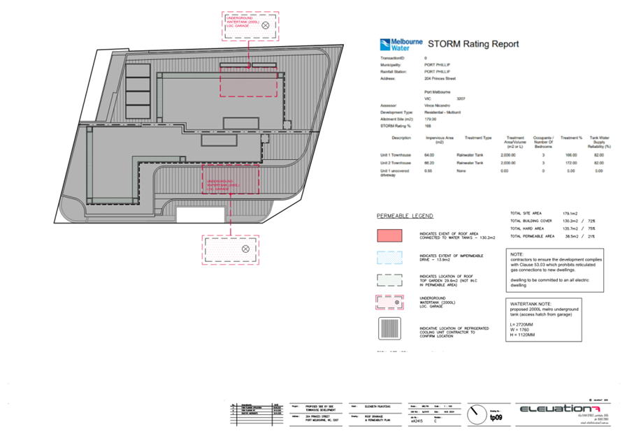
No objection, conditions required · The Water Sensitive Urban Design (WSUD) report contains acceptable stormwater management systems. · ‘Typical Rainwater tank system diagram’ showing an above ground RWT to be replaced with one that reflects the proposed underground RWT · Location, volume, and connection details for rainwater tank connections should be included on the WSUD catchment drawing · Location and dimensions of the raingarden should be included on the WSUD catchment drawing · The WSUD catchment drawing to include all impervious surfaces around the pool area that will drain to stormwater · Standard conditions requiring implementation of WSUD measures are required Planner’s comments The above issues have been addressed by a revised WSUD report. A rainwater tank system design diagram for an underground rainwater tank has not been provided, however it is not considered necessary, noting that sufficiently detailed implementation and management requirements are contained within the WSUD report. Those requirements will need to be met by the development by inclusion of standard implementation and management conditions recommended for the permit combined with endorsement of the WSUD Report. |
External referrals
9.2 The application was not required to be referred to any authorities pursuant to Clause 66 of the planning scheme, or Section 55 of the Planning and Environment Act 1987.
10. PUBLIC NOTIFICATION/OBJECTIONS
Public notification
10.1 Public notice of the application was given in mid-June to early-July 2025, including by the mailing of 35 notices to the owners and occupiers of directly adjoining and nearby properties, including objectors to the previous single dwelling application on the subject site, and display of a notice on the land.
Objections received
10.2 The application has received 18 objections. These contain grounds of objection which include the following themes:
· Poor response to heritage context
· Impact on streetscape and heritage significance
· Inappropriate bulk, form, and appearance
· Inadequate front and side setbacks
· Visibility of upper-level elements
· Inappropriate external materiality and colour selection
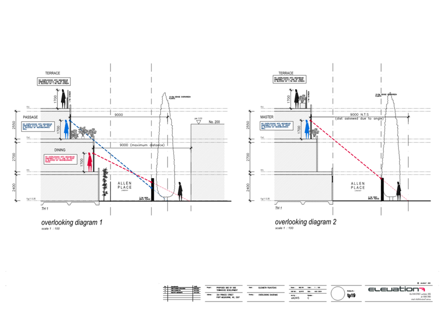
· Overlooking concerns
· Excessive site coverage
· Noise impacts from use of roof terrace, and siting of air-conditioning and pool equipment
· Approval would set inappropriate precedent
Consultation meeting
10.3 A consultation meeting was held on 14 April 2025 during assessment of the previous application for the site (PDPL/00009/2025). The meeting resulted in changes to the proposal to alter and reduce the first-floor built form. These changes have been incorporated into the plans submitted with the current application.
11. OFFICER’S ASSESSMENT
11.1 The planning controls relevant to the application contain a purpose and decision guidelines, and the following assessment will respond to the relevant requirements, along with other matters required to be considered under the planning scheme and the Planning and Environment Act 1987.
11.2 As a planning permit is only required under the provisions of the Heritage Overlay, assessment of the proposal is confined to heritage matters.
11.3 The purpose of the Heritage Overlay is to conserve and enhance places of natural or cultural significance, to conserve those elements which contribute to the significance of the place, and to ensure that development does not adversely affect the significance of heritage places. The decision guidelines of the Heritage Overlay also require consideration to be given to the applicable statement of significance and heritage study for the precinct.
11.4 Considerations under the Heritage Overlay are consistent with the broader heritage conservation policy of the Planning Policy Framework at Clause 15.03-1S (Heritage conservation). Clause 15.03-1L (Heritage policy) provides the principal policy guidance in assessing an application within the heritage overlay for the local context.
11.5 Assessment of the acceptability of the proposal with respect to relevant heritage matters will be undertaken by responding to the following questions:
· Is full demolition of the existing dwelling appropriate?
· Is the proposed replacement dwelling acceptable in the heritage context?
· Does the proposal result in amenity impacts based on the relevant planning controls?
· Are there any other matters that require consideration, including outstanding objector concerns?
Is full demolition of the existing dwelling appropriate?
11.6 Local heritage policy at Clause 15.03-1L (Heritage policy) provides only policies and strategies which relate to conservation and demolition which are relevant to heritage places which are significant or contributory.
11.7 Whilst the subject site is within a Heritage Overlay, and consequently the application is subject to a planning control which requires permission for demolition works, the existing dwelling on the site is not graded as either significant or contributory within the heritage precinct. It is not of any heritage significance.
11.8 It is acknowledged that the rear portion of the site is mapped as contributory, however this relates to an area of land which was associated with a dwelling which formerly occupied part of the site (formerly known as 61 Neville Street). This dwelling was demolished in September-October 2021 in accordance with planning permit 642/2016.
11.9 Mapping under City of Port Phillip Planning Scheme has not yet been updated following the demolition of the dwelling and the re-subdivision of the land, which incorporated the rear part of 61 Neville Street into the rear part of 80 Wright Street.
11.10 The extent of demolition proposed within the area mapped as contributory is for removal of a small shed along the southern boundary, and an area of concrete paving and raised garden beds. None of these elements are themselves of heritage significance and are acceptable to be demolished.
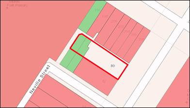
Figure 20 - Map showing contributory (green) and significant (red) places in the surrounding area
Is the proposed replacement dwelling acceptable in the heritage context?
11.11 Local heritage policy at Clause 15.03-1L (Heritage policy) provides the following strategies relevant to assessment of the proposed replacement dwelling:
General
Conservation of heritage places and new development are guided by the statement of significance, the urban context and any relevant documentary or physical evidence.
Encourage high quality, contemporary design responses for new development that respects and complements the heritage place by using a contextual approach that:
· Responds to and reinforces the contributory features of the heritage place, including:
- Building height, scale, massing and form.
- Roof form and materials.
- Siting, orientation and setbacks.
- Fenestration and proportion of solid and void features.
- Details, colours, materials and finishes.
· Conserves and enhances the setting and views of heritage places.
Avoid development that would result in the incremental or complete loss of significance of a heritage place by:
· Altering, concealing or removing a feature, detail, material or finish that contributes to the significance of the heritage place.
· Distorting or obscuring the significance of the heritage place by using historic styles and detail where these previously did not exist.
New buildings
Support new buildings that respect and complement Significant and Contributory buildings in relation to form, scale, massing, siting, details and materiality.
Roof terraces and roof decks
Encourage roof terrace and roof decks to be sited so that they are concealed when viewed from the street and, when on a corner, from the side street (excluding a laneway).
11.12 It is important to note that the sightline and concealment zone requirements of local heritage policy, which ordinarily apply to additions to existing dwellings within a Heritage Overlay do not apply to an application for a new dwelling.
11.13 The application supports the outcomes sought by local heritage policy and the objectives and decision guidelines of the Heritage Overlay by proposing a replacement dwelling which is respectful of the heritage precinct through incorporating the following:
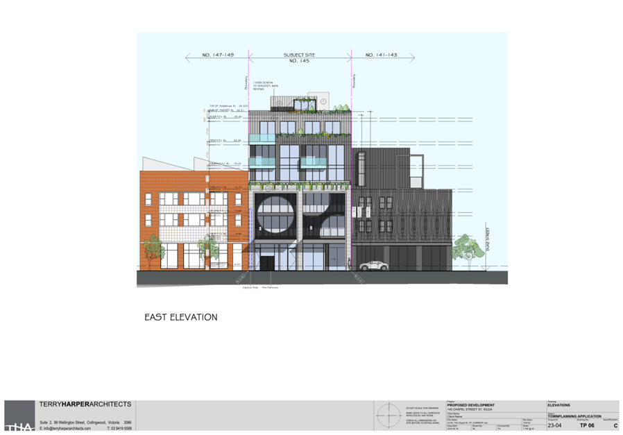
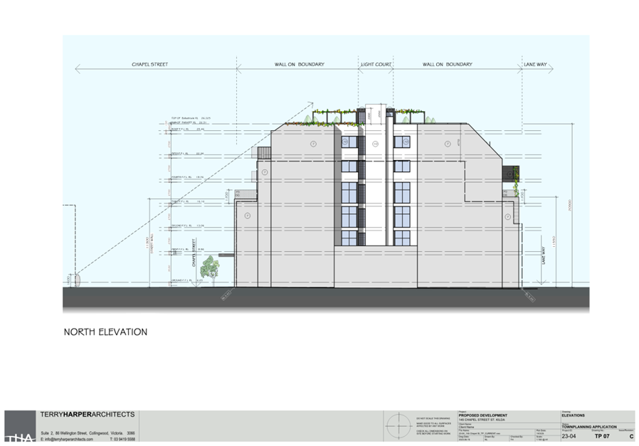
· A maximum height of 7.26 metres above natural ground level (or 9.94 AHD) which is only 0.1 metres higher than the maximum height of the two-storey addition to 202 Richardson Street, and 0.61 metres higher than the two-storey detached extension to the rear of 82 Wright Street, the two nearest examples of contemporary development to the subject site.
· A pitched roof form with a gabled end for the street-facing ground floor part of the dwelling. The roof will incorporate a dark coloured tile, taking cues from similar dark coloured slate roof materials which are a traditional materiality in this heritage context.
· Cement-coloured masonry materiality, similar in colour to the traditional render found throughout the heritage precinct, including at 82 Wright Street.
· Multi-pane windows set within a modern interpretation of a street-facing projecting window bay, taking cues from windows bays found in Victorian and Edwardian heritage dwellings.
· Asymmetrical massing and form at both ground and first floor, particularly for built form which will be sighted from Wright Street.
· A minimum street setback of 2.8 metres to the front wall which responds appropriately to the street setback of the adjoining significant-graded dwelling at 82 Wright Street, which likewise has a minimum street setback of 2.8 metres. It is acknowledged that the roof form projects forward of this to have a street setback of approximately 2 metres, however being an open-style gable end, and to a maximum height of 6.148 metres, the 2 metres setbacks is not seen to impact on the heritage streetscape.
· A first-floor minimum street setback of 9.695 metres (6.89 metres behind the ground floor street setback), which is sufficient to ensure that the first-floor built form, whilst visible from the street, will be an appropriately recessive part of the development. It is important to note that the first-floor is setback from the street further than the chimney of 82 Wright Street, ensuring sightlines to that important heritage feature are not inappropriately impacted.
· Sufficient side setbacks such that oblique views to 82 Wright Street from the streetscape will not be inappropriately impacted. It is acknowledged that a wall-on-boundary is proposed adjacent to 82 Wright Street along the south-western boundary. However, the height of boundary wall is a maximum of 3.275 metres above natural ground level (or approximately 5.72 AHD). This is approximately 1.18 metres lesser in height than the height of the wall opposite at 82 Wright Street. It is important to further note that the 82 Wright Street already has views to its frontage from the streetscape compromised by the height of its own front fencing and hedging.
· A minimum street setback to the roof terrace of 11.3 metres, ensuring there will be limited sightlines to the roof terrace from the streetscape.
11.14 Local heritage policy at Clause 15.03-1L provides the following strategies relevant to assessment of the new vehicle access:
Vehicle access
Encourage vehicle access to be:
· From a rear laneway.
Avoid onsite car parking in locations that would be visible from a street (other than a lane).
11.15 The proposed new vehicle access aligns with this policy, noting is it will provide vehicle access to the site from the rear laneway, with limited sightlines from the Neville Street streetscape.
11.16 Local heritage policy at Clause 15.03-1L provides the following strategies relevant to assessment of proposed new front fencing:
Fencing
Encourage conservation of fences or gates that contribute to the significance of a heritage place.
Ensure the height, materials, detailing and colours of front fences are appropriate to the architectural style of the heritage place.
Encourage new fences or gates for Non-contributory places to be in a simple contemporary style that complements the fences historically found in the heritage precinct.
11.17 The proposed front fencing is acceptable, noting that it will have a maximum height of 0.8 metres, and will be rendered masonry in construction. It will present as a contemporary interpretation of heritage front fencing, utilising a common materiality found throughout the heritage precinct.
Does the proposal result in amenity impacts based on the relevant planning controls?
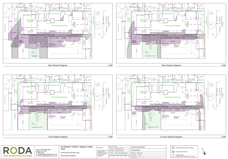
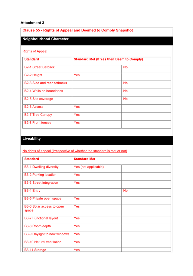
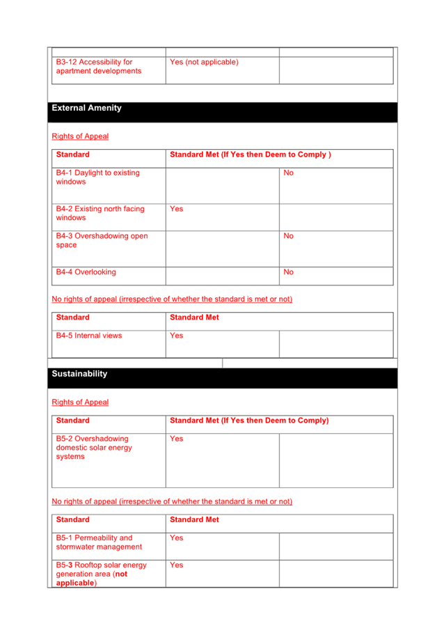
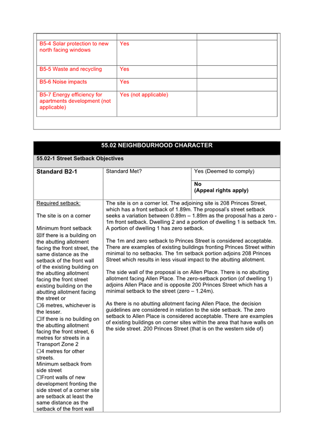
11.18 As the site is larger than 300 square metres in area, meaning the siting requirements of Clause 54 are not required to be assessed as part of this application, there is no scope to consider amenity impacts resulting from setbacks, boundary walls, daylight to existing windows, overshadowing, overlooking, or site coverage. Assessment of these requirements, and consideration of any amenity impacts resulting from them, will be considered at the building permit stage.
Are there any other matters that require consideration, including outstanding objector concerns?
Objector concerns
11.19 Noise emanating from siting of air conditioners, pool equipment, or any other domestic equipment is not contemplated by the assessment required by the planning scheme. Such noise is controlled by the requirements of the Environment Protection Act 2017.
11.20 Noise resulting from use of the roof terrace is also not contemplated by the assessment required by the planning scheme, noting that use of the land for a dwelling does not require a planning permit in this planning context.
12. COVENANTS
12.1 The title documentation submitted with the application indicates that the land is not encumbered by any registered restrictive covenants.
13. OFFICER material OR general INTEREST
13.1 No officers involved in the preparation of this report have declared a material or general interest in the matter.
14. CONCLUSION
14.1 Clause 71.02 of the planning scheme requires the decision-maker to integrate the range of policies relevant to the issues to be determined and balance the positive and negative environmental, social and economic impacts of the proposal in favour of net community benefit and sustainable development. When considering net community benefit, fair and orderly planning is key; the interests of present and future Victorians must be balanced; and, the test is one of acceptability.
14.2 A balanced assessment finds that in meeting the recommended conditions for permit the proposed development is appropriately site and context responsive and has regard for the relevant planning provisions and objectives sought by the Heritage Overlay. On this basis, it is recommended that a Notice of Decision to Grant a Permit be issued.
|
ATTACHMENTS |
1. Assessed plans |
Planning Committee
23 July 2025
|
6.2 |
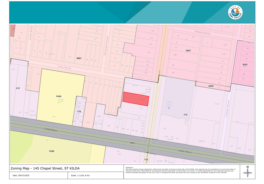
145 Chapel Street, St Kilda - PDPL/00195/2024 |
|
location/address: |
145 Chapel Street, St Kilda |
|
Executive Member: |
Brian Tee, General Manager, City Growth and Development |
|
Manager |
paul wood, manager city development |
|
PREPARED BY: |
Matthew Schreuder, Principal Planner |
1. PURPOSE
1.1 To consider and determine an application for the demolition of the existing building and construction of a mixed use, six storey building with basement car park and communal roof terrace, use of the land as dwellings and a reduction in the car parking requirements of Clause 52.06.
2. EXECUTIVE SUMMARY
|
Ward: |
Balaclava |
|
Trigger for
determination |
More than 16 objections. |
|
ApplicATION NO: |
PDPL/00195/2024 |
|
Applicant: |
Garfield Nominees Pty Ltd |
|
Existing use: |
Vacant |
|
Abutting uses: |
Commercial and residential |
|
Zoning: |
Commercial 1 Zone |
|
Overlays: |
Design and Development Overlay – Schedule 21 Carlisle Street Major Activity Centre (DDO21) Environmental Audit Overlay (EAO) Heritage Overlay - Schedule 7 St Kilda, Elwood, Balaclava, Ripponlea (HO7) Special Building Overlay – Schedule 1 Melbourne Water Main Drain (SBO1) |
2.1 This application proposes the construction of a six storey mixed use building comprising of a ground floor office with apartments above. The proposal includes 20 apartments comprising four 1-bedroom apartments with study and 16 two-bedroom apartments. A car stacker is accessed off the rear lane with 16 spaces. 22 bicycle spaces are provided.
2.2 23 car spaces are required to meet the statutory car parking rate at Clause 52.06 (Car Parking). As 16 spaces are provided, the application seeks a waiver of 7 spaces.
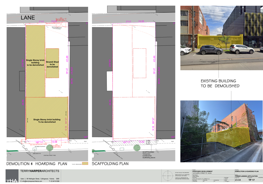
2.3 The proposal includes the demolition of the non-contributory heritage graded buildings on the site. The single storey commercial building has been vacant for a number of years.
2.4 The application was in advertised in January 2025. 18 objections have been received at the time of writing this report. Keys concerns raised include the following which are outlined in more detail within the report:
· Impact on heritage significance of 147 Chapel Street.
· Inappropriate heritage response.
· Non-compliance with the design objectives of the Design and Development Overlay.
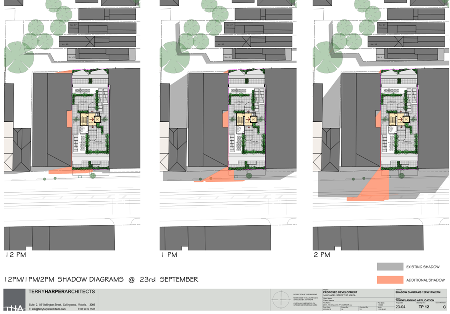
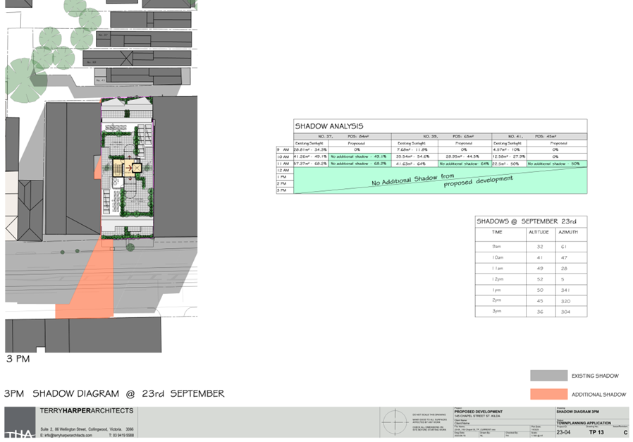
· Impact on the amenity of neighbouring properties including overlooking, overshadowing, loss of daylight and noise from roof terrace.
· Inadequate internal amenity.
· Traffic impacts related to use of the lane, car parking issues, traffic noise, pedestrian safety and access to the lane during construction.
· Inaccuracies on plans.
· Waste disposal.
· Impact on property value.
2.5 The proposal is acceptable for the following reasons:
· Strong strategic support for increased residential densities in the Carlisle Street Major Activity Centre with proximity to jobs, services and public transport.
· The proposal is an acceptable response to the DDO21. In particular, the development is well-designed and provides an active street edge, appropriate street wall and upper-level setbacks. The scale of the building is commensurate with other development within the Carlisle Street Major Activity Centre.
· The proposal provides an appropriate level of internal amenity for future residents.
· Off-site amenity impacts are acceptable.
· The provision of 16 residential car spaces is acceptable given proximity to public transport and the location within the Principal Public Transport Network (PPTN).
· The provision of 26 bicycle spaces exceeds the 6 spaces required by Clause 52.34 – Bicycle Facilities. This further supports the reduction to the car parking requirements.
· Melbourne Water supports the proposal subject to conditions.
2.6 The proposal is recommended for approval subject to the conditions.
|
3.1 That the Responsible Authority, having caused the application to be advertised and having received and noted the objections, issue a Notice of Decision to Grant a Permit for Application No. PDPL/00195/2024 at 145 Chapel Street, St Kilda. 3.2 That a Notice of Decision to Grant a Permit be issued subject to the following permissions:
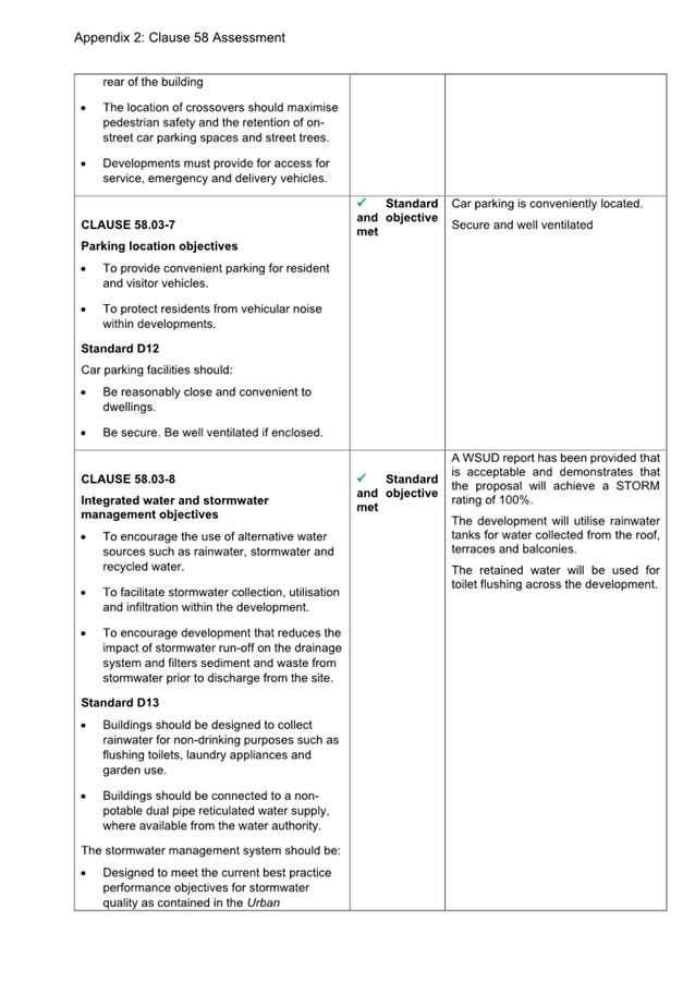
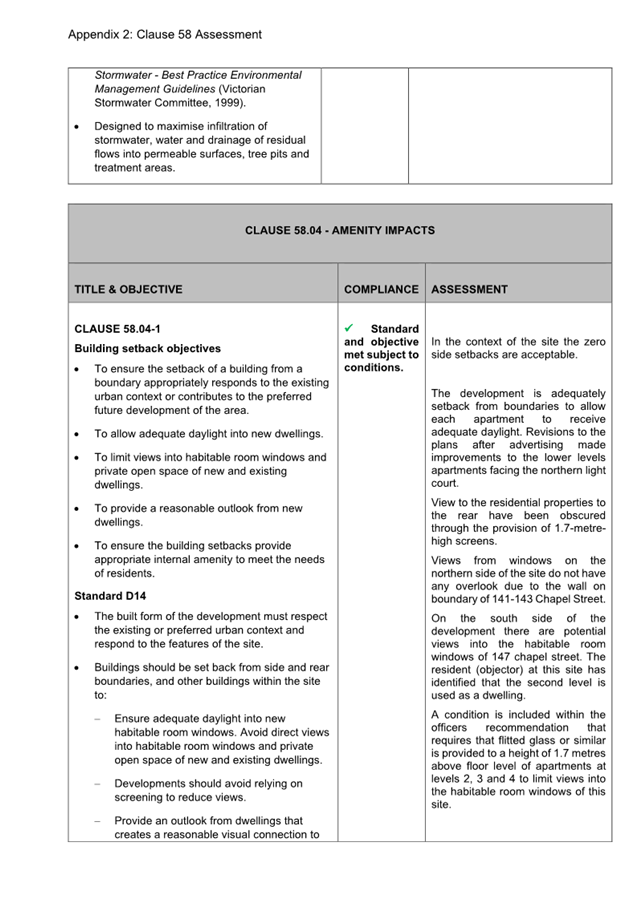
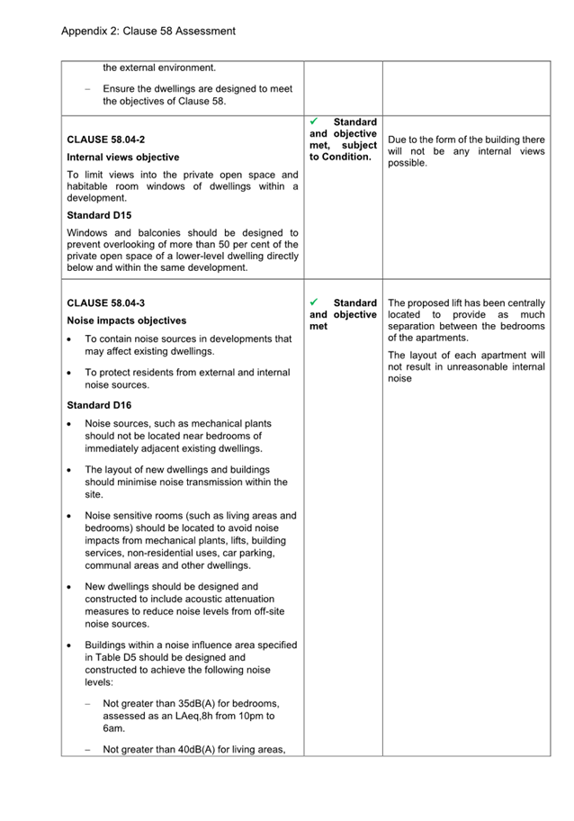
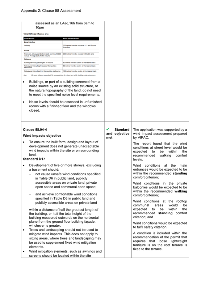
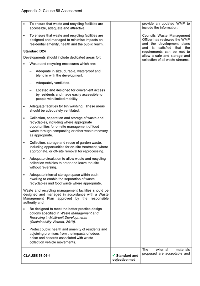
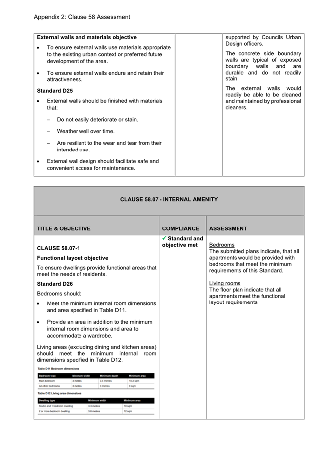
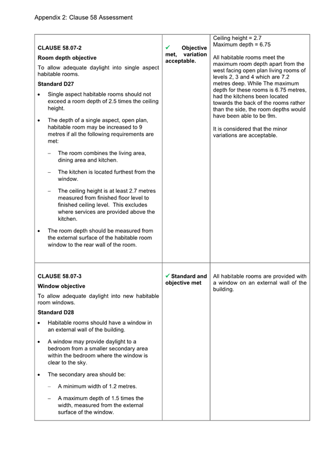
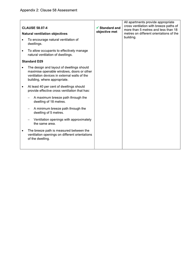
3.3 That the decision be issued subject to the following conditions: Amended Plans Required 1 Before the use and development starts, amended plans to the satisfaction of the Responsible Authority must be submitted to and approved by the Responsible Authority. When approved, the plans will be endorsed and will then form part of the permit. The plans must be drawn to scale with dimensions and must be generally in accordance with the plans identified as ‘Proposed development – 145 Chapel Street, TP01-TP-18’, prepared by Terry Harper Architects date stamped as received by Council on 25 March 2025 and additional revision C plans TP-03, TP-04 and TP-05 received on 22 April 2025), but modified to show: a) The changes shown on the revision C plans to be incorporated on the full suite of plans for endorsement (ie. any changes to also be reflected on the elevations, etc). b) The provision of obscure glass or similar to a height of 1.7 metres above finished floor level of the south facing bedrooms on levels 2, 3 and 4 to avoid direct views into the habitable room windows of the dwelling at level three at 147 Chapel Street. c) Deletion of the angled parapet along level six fronting Chapel Street. d) Provision of an access door to the area containing the solar panels and air conditioning units to the south of the front communal roof terrace space. e) External louvres to the west-facing kitchen/living area of level 5 shown on floor plans. f) Details of the garage ventilation to be in accordance with Standard D12 of Clause 58.03-7 (Parking location objectives). g) The dark ‘Monument’ colour on the upper levels modified with to be a lighter colour that remains distinguishable from the first three levels of the street wall. h) The fire services cupboard on the Chapel Street frontage to be designed as an integral part of the building architectural design, and where possible reduced in size to ensure a greater proportion of glazing to office. i) The verandah on Chapel Street frontage to extend the full length of the street frontage. j) Any changes as required by Condition 15 (Landscape Management Plan), Condition 18 (Waste Management Plan) and Conditions 22 to 27 (Melbourne Water Conditions). No Alterations 2 The layout of the development must not be altered from the layout on the approved and endorsed plans (unless the Port Phillip Planning Scheme specifies a permit is not required) without the written consent of the responsible authority. No change to external finishes 3 All external materials, finishes and colours as shown on the endorsed plans must not be altered without the written consent of the responsible authority No equipment or services 4 No plant, equipment or domestic services (including any associated screening devices) or architectural features, other than those shown on the endorsed plans, are permitted, except where they would not be visible from a street (other than a lane) or public park without the written consent of the responsible authority. Privacy Screening Must be installed 5 Before the development is occupied, all window screening must be installed in accordance with the endorsed plans and maintained to the satisfaction of the responsible authority. Walls on or Facing the Boundary 6 Before the development is occupied, all new or extended walls on or facing the boundaries of adjoining properties or a laneway must be cleaned and finished to the satisfaction of the responsible authority. Urban Art Plan 7 Before the development is occupied, an Urban Art Plan to the satisfaction of the responsible authority must be submitted to and approved by the responsible authority. When approved, the Urban Art Plan will be endorsed and will then form part of the permit. The Urban Art Plan must have regard to Clause 15.01-2L-03 of the Port Phillip Planning Scheme and detail the provision of an urban art contribution for the development that: a) Offers aesthetic appeal, functionality and utility. b) Takes on an artistic approach that either promotes integration (for example response, memory and facilitation for ‘placemaking’), and/or intervention (for example provocation, parody and challenge for ‘agenda-setting’). Urban art in accordance with the approved plan must be installed to the satisfaction of the responsible authority before the building is occupied. Updated Sustainability Management Plan 8 Concurrent with the endorsement of plans as required by condition 1 of this permit, an updated Sustainability Management Plan (SMP) must be submitted to and approved by the Responsible Authority. The updated SMP must be generally in accordance with the SMP submitted with the application titled ‘145 Chapel Street, St Kilda’ and dated 30 October 2024, prepared by AV – Low Impact Development Consulting, but modified to include reflect the decision plans referenced in Condition 1 of the permit and any changes required by Condition 1. Where alternative Environmentally Sustainable Design (ESD) initiatives are proposed, the responsible authority may vary the requirements of this condition at its discretion, subject to the development achieving equivalent (or greater) ESD outcomes. The provisions, recommendations and requirements of the endorsed SMP must be implemented and complied with to the satisfaction of the responsible authority and must not be varied except with the written consent of the responsible authority. As Built Report for Environmentally Sustainable Design measures. 9 Before the development is occupied, an As-Built report for Environmentally Sustainable Design (ESD) measures is to be provided from a suitably qualified person or company, must be submitted to and endorsed by the responsible authority. The Report must confirm and provide supporting evidence that all ESD initiatives in the endorsed Sustainability Management Plan and Water Sensitive Urban Design (WSUD) report have been implemented in accordance with the approved plans/documents to the satisfaction of the responsible authority. Car and Bicycle Parking Layout 10 Before the development is occupied, the areas set aside for the parking of vehicles and bicycles and access lanes as shown on the endorsed plans must be: a) Constructed. b) Properly formed to such levels that may be used in accordance with the plans. c) Surfaced with an all-weather seal coat (as appropriate). d) Drained. e) Provided with lighting that is designed, baffled and located to prevent adverse effects on adjoining land. All to the satisfaction of the responsible authority. At all times car spaces, access lanes and driveways must be kept available for these purposes. Once constructed, these areas must be maintained to the satisfaction of the responsible authority. Vehicle Crossings 11 Before the development is occupied, the vehicle crossing must be constructed in accordance with Council’s current Vehicle Crossing Guidelines and standard drawings to the satisfaction of the responsible authority. Car Parking Stacker Maintenance and Provision 12 Before the development is occupied, a Car Stacker System Management Plan (CSSMP) to the satisfaction of the Responsible Authority must be submitted to and approved by the Responsible Authority. When approved, the plan will be endorsed and will then form part of the permit. The CSSMP must show: a) Allocation of car spaces according to vehicle size and typ. b) Ongoing maintenance of the car stacker system. c) Instructions to owners and occupiers about the operation of the car stacker system. d) Communicating to prospective residents about the availability of car stacker spaces and sizes. The provisions, recommendations and requirements of the endorsed Car Stacker System Management Plan must be implemented and complied with to the satisfaction of the responsible authority and must not be varied except with the written consent of the responsible authority. 13 The mechanical car stackers must be maintained in a good working order and be permanently available for the parking of vehicles in accordance with their purpose, to the satisfaction of the responsible authority. Legal Point of Discharge 14 The development discharge to the legal point of discharge and otherwise must be drained to the satisfaction of the responsible authority. Landscape Plan 15 Before the development starts, a Landscape Plan to the satisfaction of the responsible authority must be submitted to and approved by the responsible authority. When approved the plan will be endorsed and will then form part of the permit. The landscape plan must be prepared by a person suitably qualified or experienced in landscape design and must be drawn to scale with dimensions. All species selected must be to the satisfaction of the responsible authority. The Landscape Plan must show: a) A planting schedule of all proposed vegetation including botanical names; common names; pot sizes; sizes at maturity; quantities of each plant and details of surface finishes of pathways and driveways. b) Landscaping and planting within all open space areas of the site. c) Water sensitive urban design. d) All dimensions of planters, including size depth and soil volumes. e) Seating and other communal facilities such as a BBQ to the roof terraces. f) Ongoing maintenance of landscaping including replacing any dead, diseased, dying or damaged plants. Completion of Landscaping 16 Before the development is occupied, the landscaping as shown on the endorsed Landscape Plan must be carried out and completed to the satisfaction of the responsible authority, or at such later date as is approved by the responsible authority. Construction Management Water Sensitive Design Measures 17 All construction (including demolition and excavation) must be carried out, so that: a) No water containing oil, foam, grease, scum or litter will be discharged to the stormwater drainage system from the site. b) All stored wastes are kept in designated areas or covered containers that prevent escape into the stormwater system. c) The amount of mud, dirt, sand, soil, clay or stones deposited by vehicles on the abutting roads is minimised when vehicles are leaving the site. d) No mud, dirt, sand, soil, clay or stones are washed into, or are allowed to enter the stormwater drainage system. e) The site is developed and managed to minimise the risks of stormwater pollution through the contamination of run-off by chemicals, sediments, animal wastes or gross pollutants in accordance with currently accepted best practice. Waste Management Plan 18 Concurrent with the endorsement of plans as required by condition 1 of this permit, an updated Waste Management Plan (WMP) must be submitted to and approved by the Responsible Authority. The WMP must be generally in accordance with the WMP prepared by Waste Space Solutions, titled ‘145 Chapel Street, St Kilda’ and dated 17 October 2024, but modified to address the following: a) Noise mitigation measures for the movement and collection of bins from within the site. b) Collections vehicles to not block Duke Street while the operator bin tugs the bins to street level. c) Bins presented to the Duke Street kerbside, or an alternative truck parking and bin collection area must be specified. d) A generic residential apartment and commercial tenancy floor plan showing waste, recycling and food waste disposal points. e) Accessibility specifications of the waste chutes. f) Scaled drawings of the bin room size and clearance. g) Disability access to the screened bin areas for Glass and FOGO. h) The hard waste area identified on the plans. i) Scaled waste management drawings to include: i. How bins in the waste storerooms will be collected. ii. Collection area location. iii. Movement diagrams of each material from disposal, storage, and collection points including any gradient/slope/lift. iv. Swept path diagrams illustrating sufficient access to collection points for all vehicles required to collect from the development. The provisions, recommendations and requirements of the endorsed Waste Management Plan must be implemented and complied with to the satisfaction of the responsible authority and must not be varied except with the written consent of the responsible authority. No Reticulated Gas 19 Any new dwelling allowed by this permit must not be connected to a reticulated gas service (within the meaning of clause 53.03 of the relevant planning scheme). This condition continues to have force and effect after the development authorised by this permit has been completed. Environmental Assessment 20 Before the development starts (other than for necessary demolition and investigation works forming part of the environmental site assessment process), a Preliminary Risk Screen Assessment Statement to the satisfaction of the Responsible Authority must be submitted to and approved by the Responsible Authority. The Preliminary Risk Screen Assessment Statement must be prepared by a suitably qualified environmental professional in accordance with the Potentially Contaminated Land General Practice Note (Department of Environment, Land, Water and Planning, July 2021). The report must include recommendations as to whether the condition of the land requires an Environmental Audit to be conducted taking into account the proposed uses. The permit holder must comply with the findings of the Preliminary Risk Screen Assessment Statement to the satisfaction of the Responsible Authority, including if required the preparation of an Environmental Audit. If an Environmental Audit is required, then before the development starts (other than for necessary excavation, demolition and investigation works) an Environmental Audit must be undertaken pursuant to section 208 of the Environment Protection Act 2017 and an Environmental Audit Statement prepared and provided to the Responsible Authority. 21 Where an Environmental Audit Statement is issued for the land in accordance with Condition 21: a) The buildings and works and the use(s) of the land that are the subject of this permit must comply with all directions and conditions contained within the Statement to the satisfaction of the Responsible Authority; b) Before the use or development starts (other than for necessary excavation, demolition and excavation works) and before the issue of an Occupancy Permit under the Building Act 1993, a letter prepared by an Environmental Auditor appointed under Division 1 of Part 8.3 of the Environment Protection Act 2017 must be submitted to the Responsible Authority to verify the directions and conditions contained in the Environmental Audit Statement are satisfied; and c) Where any condition of that Statement requires any maintenance or monitoring of an ongoing nature, the Owner must enter into an Agreement with Council under section 173 of the Planning and Environment Act 1987. Where a section 173 Agreement is required, the Agreement must be executed before the development starts (other than for necessary excavation, demolition and excavation works). All expenses involved in the drafting, negotiating, reviewing, lodging, registering and execution of the Agreement, including those incurred by the Responsible Authority, must be met by the Owner. Melbourne Water conditions 22 The Finished Floor Levels (FFLs) of all ground floor areas, including all lift and stair lobbies, must be set no lower than 6.03 metres to Australian Height Datum (AHD) (with the exception of service and transitional areas containing landings, steps or ramps to the satisfaction of Melbourne Water). 23 Any/all basement entry and exits points, including lift entries, stairwells, windows, openings and vents, that could allow entry of floodwaters to the basement level, must be set no lower than 6.03 metres to Australian Height Datum (AHD). 24 The ramp to proposed car stacker/ carparking system must incorporate a flood proof apex set no lower than 5.82 metres to Australian Height Datum (AHD) to prevent floodwaters entering the basement levels during a flood event. 25 Flood resistant materials must be used for the construction of floor levels and walls below the Nominal Flood Protection Level 6.03m AHD. 26 Any electrical installations within areas subject to flooding must meet the applicable standards of the relevant authority. 27 The layout of buildings and works at ground level as shown on the plans must not be altered without prior written consent from Melbourne Water. Permit expiry 28 This permit will expire if one of the following circumstances applies: a) The development is not started within 2 years of the issued date of this permit. b) The development is not completed within 4 years of the issued date of this permit. c) The use does not start within 2 years of completion of the development. In accordance with Section 69 of the Planning and Environment Act 1987, an application may be submitted to the responsible authority for an extension of the periods referred to in this condition. |
4. RELEVANT BACKGROUND
4.1 There is no relevant history or background for this application.
5. PROPOSAL
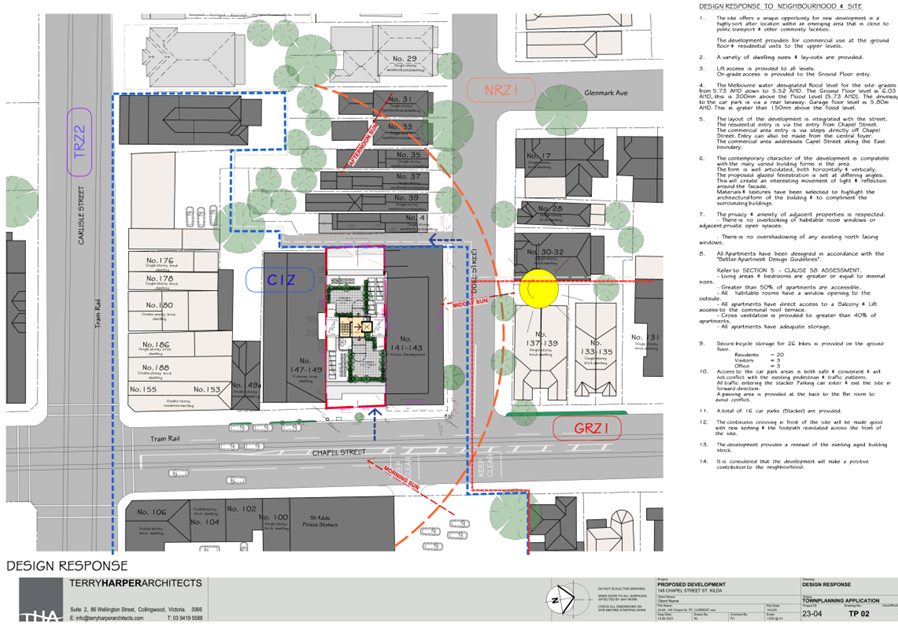
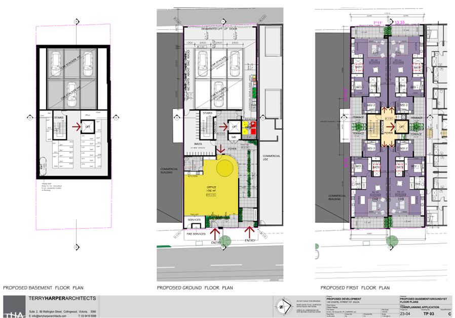
5.1 The application includes the demolition of the existing non-contributory buildings on the land and the construction of a six storey building containing the following elements:
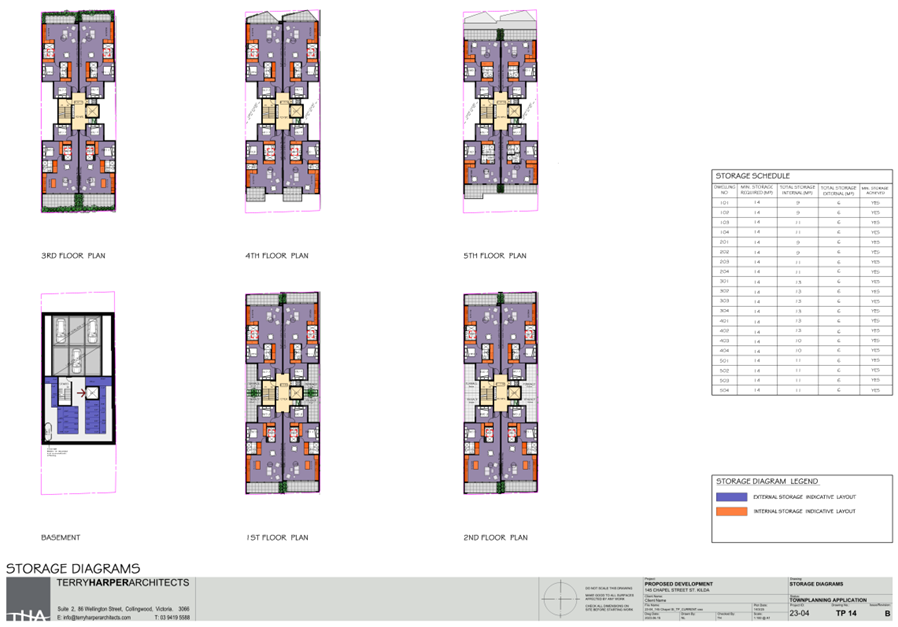
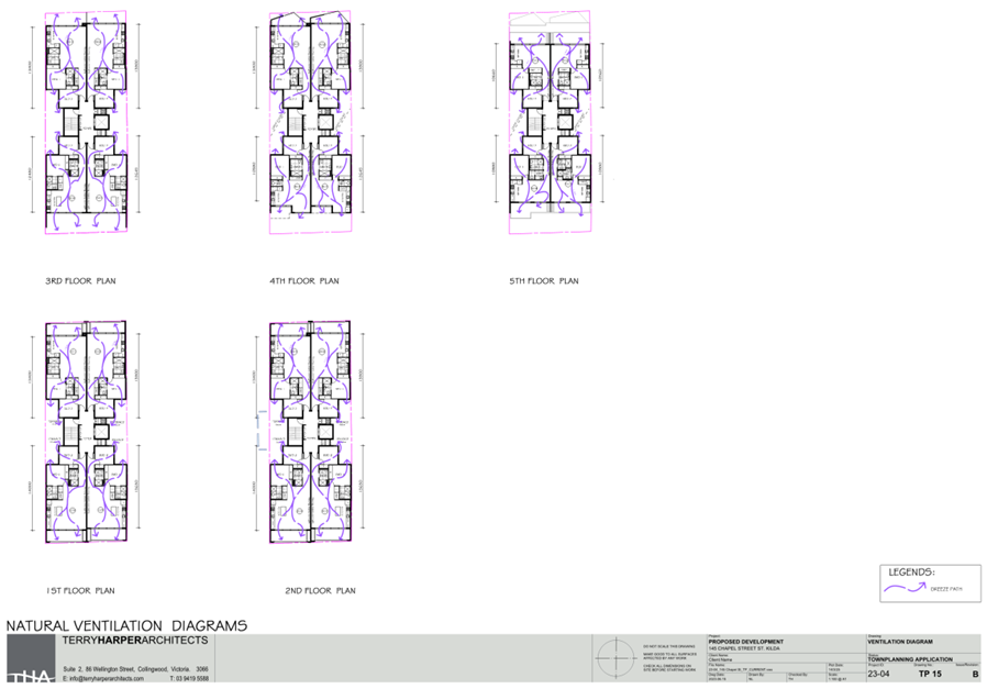
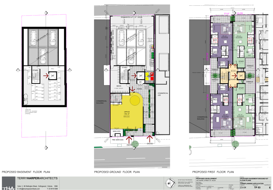
· Basement level with car stacker pit, stairs and lift access and apartment storage units.
· The ground floor consists of 106sqm of office space, the residential entry and foyer with access to stairs and lift, the bike store and bin rooms and a 16-space car stacker.
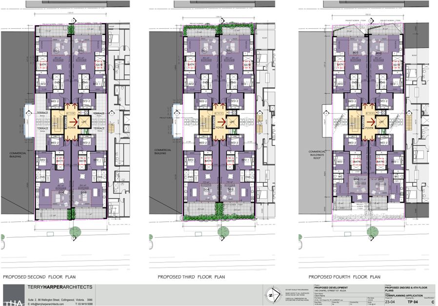
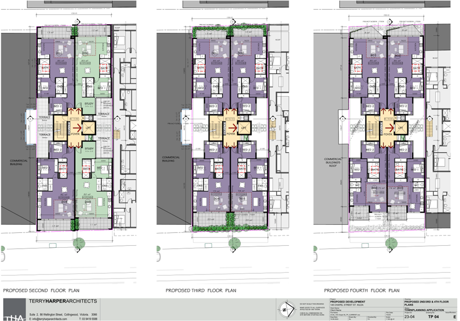
· The first floor comprises four apartments, two with two bedrooms and two with 1 bedroom and additional study. All apartments have access to a terrace within the light court and separate area of private open space on a balcony with direct access from a living room.
· The second floor has an identical layout to the first floor, consisting of four apartments, but without access to a light court terrace.
· The third, fourth and fifth floor comprise of 4 two-bedroom apartments with access to a balcony accessed off the living room.
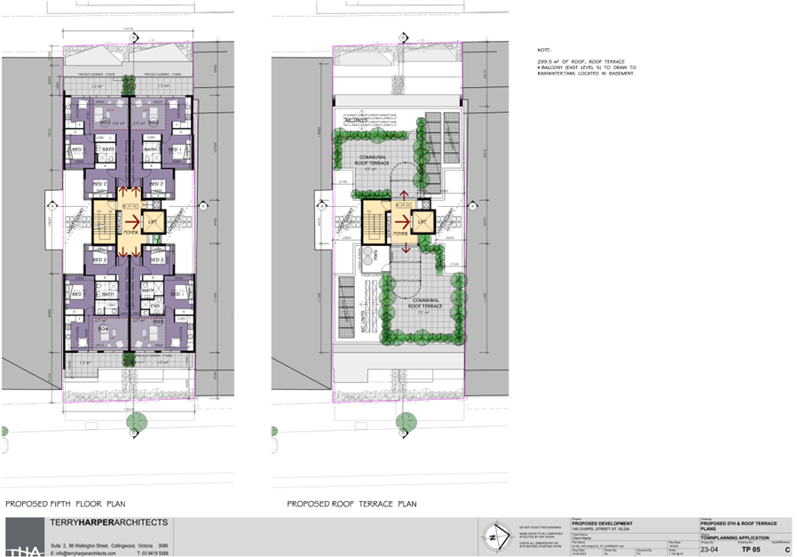
· The roof terrace comprises two separate areas of communal open space accessed via the lift and stairs. Perimeter planting and service areas including solar panels are located on the roof.
5.2 A full set of the plans are contained in the attachments to this report, however the following images show the layout of each floor:
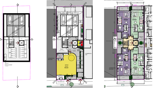
Figure 1 - proposed basement, ground and first floor.
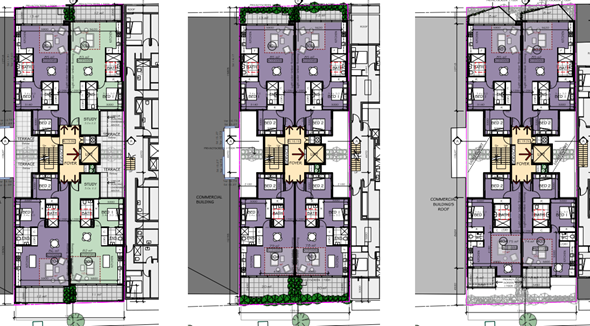
Figure 2 - Second, third, fourth floor plans.
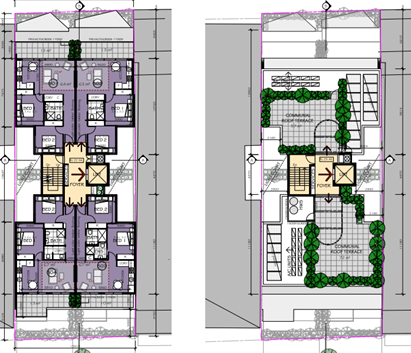
Figure 3 - Fifth floor and roof terrace plans.
5.3 The proposal also includes:
· Use of the land as dwellings in the Commercial 1 Zone, as the frontage of the dwellings at ground level exceeds 2 metres.
· A reduction of the number of car parking spaces.
6. SUBJECT SITE AND SURROUNDS
Subject site
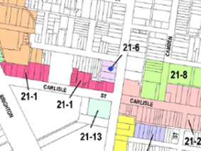
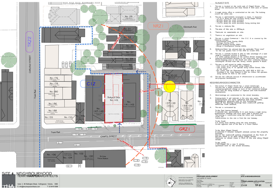
6.1 The subject site is located on the western side of Chapel Street, approximately 50 metres north of the intersection with Carlisle Street, St Kilda. The site is rectangular in shape and has a frontage to Chapel Street of approximately 13.5 metres and a depth of approximately 36.58 metres. The subject site has a total area of approximately 503 square metres.
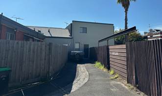
6.2 The site has a rear abuttal to an unnamed lane that provides access to the rear of shops fronting Carlisle Street and dwellings fronting Duke Street.
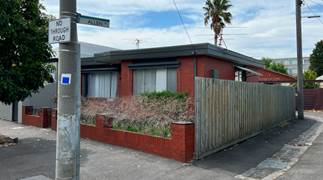
6.3 The site is currently occupied by a single storey commercial building that is vacant and has been closed off from the street with hording panels.
6.4 Car parking is accessible from the rear lane.
6.5 The subject site is located within the Chapel Street North Precinct of the Carlisle Street Major Activity Centre.
6.6 The following are images of the subject site:
|
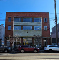
Figure 4 - subject site at 145 Chapel Street, St Kilda. Source: Council officer. July 2025 |
Figure 5 - Rear of subject site from lane and 147 Chapel Street to the south. Source: Council officer. July 2025 |
Surrounding land
6.7 To the south of the site there are various commercial buildings within the Commercial 1 Zone, to the rear of the site is land within the Neighbourhood Residential Zone – Schedule 1 and to the north of the site beyond Duke Street, along Chapel Street the area is residential within the General Residential Zone.
6.8 Directly abutting to the north is 141-143 Chapel Street which contains a 5 storey mixed use building with a restaurant at street level and four levels of apartments above constructed in approximately 2011. The site is a corner lot with secondary frontage to Duke Street. The residential access is from Duke Street as well as access to the car parking.
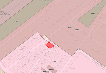
6.9 To the south of the site is 147 Chapel Street which contains a three-storey building constructed in 1942. The site is within the heritage overlay and has a significant grading.
6.10 The building has a commercial tenancy at street level, offices at the first floor and has a dwelling that is currently being renovated at the second level. The site has a rear abuttal to the lane off Duke Street.
6.11 The site is provided with a light court along the shared boundary with the subject site. A wall is constructed along the entire boundary at ground level.
6.12 To the east of the subject site, on the opposite side of Chapel Street is the St Kilda Police Station. The building is a three-storey significant graded heritage building with individual significance and a site-specific heritage citation.
6.13 To the west of the subject site is an unnamed laneway.
6.14 On the opposite side of the lane is a row of single storey attached Victorian cottages constructed of weatherboard with pitched iron roofs. The narrow lots have frontages of approximately 5 metres to Duke Street. Small areas of secluded private open space are located to the rear of the dwellings. Despite the small area of the lots at around 190-250 square metres, there is a variety of small canopy trees on each of the sites within the front setbacks and rear yards.
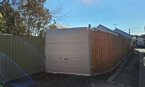
6.15 Nearest to the subject site is 41 Duke Street which has rear access to the laneway and provides off street car parking within the secluded private open space area. The lot has a timber paling fence along the lane of approximately 2.5 metres.
6.16 The site is located within the Principal Public Transport Network. It is well serviced by public transport with Balaclava Station within 300 metres and trams available along Chapel Street, Carlisle Street and St Kilda Road.
6.17 The site is within the Carlisle Street Major Activity Centre with various major supermarkets within proximity of the site as well as other essential services such as medical clinics.
6.18 The following are images of the surrounding area:
|
Figure 6 - 141-143 Chapel Street to the north of the subject site. Source: Council officer. July 2025 |
Figure 7 - 147 Chapel Street to the south of the subject site. Source: Council officer. July 2025 |
|
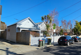
Figure 8 - Row of Victorian cottages to the west of the subject site and entrance to rear lane. Source: Council officer. July 2025 |
Figure 9 - Rear of 41 Duke Street with vehicular access to the rear private open space. Source: Council officer. July 2025 |
|
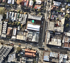
Figure 10 - Aerial Photograph of subject site (identified with green marker) and surrounds. Source: Nearmap 26 May 2025 |
Figure 11 - Carlisle Street Major Activity Centre with subject site identified by blue dot. |
7. Permit Triggers
7.1 The following zone and overlay controls apply to the site, with planning permission required as described.
|
Zone or Overlay |
Why is a permit required? |
|
Clause 34.01 Commercial 1 Zone (C1Z) |
Use Clause 34.01-1 ‘Table of Uses’ lists accommodation as a Section 1 – Permit not required subject to any frontage at ground floor not exceeding 2 metres. As the residential frontage, at 2.7m, is more than 2 metres, a permit is required for the use of the land for accommodation. Works Clause 32.08-7 states that a permit is required to: · Construct a building or construct or carry out works. A planning permit is required under the zone. |
|
Clause 43.01 Heritage Overlay (HO7) – St Kilda, Elwood, Balaclava, Ripponlea |
Clause 43.01-1 states that a permit is required to: · Demolish or remove a building. · Construct a building or construct or carry out works. A planning permit is required under the HO7. |
|
Clause 43.02 Design and Development Overlay Schedule 21 (DDO21) – Carlisle Street Major Activity Centre |
Clause 43.02-2 states that a permit is required to: · Construct a building or construct or carry out works. A planning permit is required under the DDO21. |
|
Clause 44.05 Special Building Overlay Schedule 1 (SBO1) – Melbourne Water Main Drain |
Clause 44.05-2 states that a permit is required to: · Construct a building or construct or carry out works. A planning permit is required under the SBO1. |
|
Clause 52.06 Car Parking |
Clause 52.06-3 states that a permit is required to: · Reduce the number of car parking spaces required under Clause 52.06-5. A planning permit is required under Clause 52.06. |
8. PLANNING SCHEME PROVISIONS
8.1 The following provisions of the Municipal Planning Strategy (MPS) are relevant to this application:
Clause 02 MPS
02.1 Context
02.02 Vision
02.03 Strategic Directions
02.04 Strategic Framework Plans
8.2 The flowing provisions of the Planning Policy Framework (PPF) are relevant to this application:
Clause 11 Settlement
11.01-1R Settlement – Metropolitan Melbourne
11.02 Managing Growth
11.03-1S Activity Centres
11.03-1L–03 Carlisle Street Major Activity Centre
Clause 15 Built Environment and Heritage
15.01 Urban Design
15.01-1L -02 Urban Design
15.01-2L-01 Building Design
15.01-2L-02 Environmentally Sustainable Development
15.01-2L-03 Urban Art
15.03 Heritage
15.03-1L Heritage Policy
Clause 16 Housing
16.01 Residential Development
16.01-1S Housing supply
16.01-1R Housing supply – Metropolitan Melbourne
16.01-1L-01 Housing diversity
16.01-1L-02 Location of residential development
Clause 18 Transport
18.01-1S Land use and transport integration
18.01-1L-01 Land use and transport integration
18.02-4L-01 Car parking
18.02-3L-02 Loading facilities
Clause 19 Infrastructure
19.03 Development infrastructure
19.03-3S Integrated Water Management
19.03-3L Stormwater management (water sensitive urban design)
19.03-5L Waste and Resource Recovery
8.3 The following Particular and General Provisions are relevant to this application:
Clause 52.06 Car Parking
Clause 58 Apartment developments
Clause 65 Decision Guidelines
8.4 The following operational provisions are relevant to this application:
Clause 71 Operation of this planning scheme
71.01 Operation of the Municipal Planning Strategy
71 .02 Operation of the planning policy Framework
71.03 Operation of Zones
71.04 Operation of Overlays
71.05 Operation of Particular provisions
8.5 There are no planning scheme amendments relevant to this application.
9. REFERRALS
9.1 Internal referrals
The application was referred to the following areas of Council for comment. A summary of referral comments is as follows:
Heritage Advisor
Councils Heritage advisor does not object to the demolition of the existing buildings on the subject site, nor to the proposed new building.
Urban Design
Councils Urban Design officers support the broad form of development in this location, however have identified the following areas that should be addressed:
· Limited diversity of apartment types across the proposal.
· Poor daylight access to some of the bedrooms.
· Potential overlooking into the dwelling at 147 Chapel Street.
· Poor outlook from some bedrooms facing the internal light courts.
· East and West facing balconies and windows of Level 5 and Level 4 exposure to heat gain.
· The angled parapet at the top of the front façade unnecessarily adds complex form.
· Lack of maintenance door access to the solar panel and AC units on the roof located to the south of the Communal Roof Terrace.
A condition is included within the recommendation to require an obscured glass to the bedrooms of levels three, four and five on the south elevation to limit views into the dwelling at 147 Chapel Street.
A condition is included that requires amended plans to show the removal of the angled parapet from the front elevation of level five forward of the roof terrace as well as the provision of a door to access the solar panels and AC units to the south of the front communal roof terrace area.
While the proposal only provides 1 and 2 bedroom apartments, it is considered that these apartment types provide sufficient diversity in accordance with the dwelling diversity objective of Clause 58.02-3.
Heat gain to some of the bedroom windows and balconies is inevitable. The ESD performance of the building is assessed in this report and is on balance an acceptable outcome.
An outlook for bedrooms into a light court is not unreasonable or uncommon. Daylight and outlook matters are discussed in the assessment section of this report
Sustainable Design
Councils ESD officer has made the following suggestions to improve the ESD performance of the building:
· The external louvres to west-facing kitchen/living area of level 5 are to also be shown on floor plans.
· Passive ventilation is to be provided to garage.
· External north and west walls appear to be clad in metal sheeting of a Monument-type colour. This is considered too dark and will result in heat gain. This must be a lighter colour with higher reflectivity and a low solar absorptance value of =0.45. A materials schedule is to be provided in support of this.
· E/V charging is to be provided to all car parking spaces.
Conditions contained in the recommendation address the dark colours proposed, external louvres to west-facing kitchen/living area of level 5 and passive ventilation to the garage. Subject to these conditions the proposal provides an acceptable ESD response.
As the car parking is provided within car stackers it is not currently practicable to provide charging points for the car spaces.
Traffic
Councils traffic engineers raised concerns with the following matters:
· Provision of car parking.
· Appropriate space provided within the building to accommodate the stacker system.
· Provision of an automated door for the stackers to minimise wait times.
· Pedestrian safety in the lane way.
A condition is included within the officer recommendation to provide an automated door to the stackers to minimise wait times when entering the site.
The proposed reduction in car spaces is acceptable in this location. The site is well serviced by public transport and other services. This is detailed in the body of the report.
The ground floor plans demonstrates that there is sufficient space to accommodate the stacker system. There is additional space around the stacker that would be able to allow minor variations in the dimensions of the stacker without impacting on circulation around the ground floor.
The laneway will have much lower usage than a typical road. Vehicles will be travelling at slower speeds given the width of the laneway. The setback of the car stacker also provides view lines from the laneway to existing vehicles. The pedestrian safety of the entry and laneway is considered acceptable.
The conditions included within the officer recommendation will ensure that wait times to enter the stacker and pedestrian safety is managed to an acceptable level<insert text>
Waste Management
Waste officers identified a few matters that require further clarification within the Waste Management Plan (WMP), or that need to be shown on the plans prior to the endorsement of the plans.
In this respect, an amended WMP forms part of the recommendation which resolves the matters raised. These matters include:
· Noise reduction measures.
· Prevention of litter entering stormwater.
· Bins must be presented kerbside on Duke Street.
· Collection vehicles must not block Duke Street.
· Floor plans of an apartment and the commercial tenancy showing waste, recycling and food waste disposal points.
· Scale drawings required for bin rooms and accessways for bin transportation.
· Disability access for the proposed screened bin area for Glass and FOGO.
· The hard waste storage.
Development engineers
No objection to the proposal but suggest that the site is drained to the legal point of discharge, and that the car parking areas include lighting.
9.2 External referrals
Melbourne Water
The application was referred to Melbourne Water in their capacity as a determining referral authority pursuant to Clause 66 of the Scheme. Melbourne Water has no objection to the proposal on the basis that conditions are included as part of any decision. These are included in the recommendation.
10. PUBLIC NOTIFICATION/OBJECTIONS
10.1 Notice of the application was given by ordinary mail to the owners and occupiers of surrounding properties (91 letters) and the display of two notices on the site for a 14 day period, in accordance with Section 52 of the Planning and Environment Act 1987. 18 objections have been received.
10.2 The key concerns raised are summarised below, noting that responses are either included below (italics) or otherwise discussed at Section 11):
|
Neighbourhood character and heritage impacts |
|
· Impact on the heritage significance of the building at 147-149 Chapel Street. |
|
· The proposed materials and finishes are not sympathetic to the heritage overlay, including the grey side elevation wall. |
|
· Does not provide an appropriate transition in scale down to 147-149 Chapel Street. The two additional storeys of height above 147 Chapel Street is acceptable. The upper levels are setback from by 3-5 metres above the street wall which makes these levels recessive. |
|
· Does not comply with the height controls of the Design and Development Overlay. |
|
Amenity impacts |
|
· Unreasonable overlooking. |
|
· Unreasonable overshadowing. |
|
· Unreasonable impact on daylight to adjoining properties. |
|
· The roof top terrace private open space will result in excessive noise. The proposal will not result in unreasonable noise in this context. The use of the land for apartments is only triggered as a result of the width of the entry at street level being more than two metres wide. This is design consideration relating to appropriate activation of the commercial streetscape. The use would otherwise be as of right. Residential noise typical of higher density development is to be expected and acceptable. Roof terraces are a common and supported provision of private open space for apartment developments and commercial land uses. |
|
Onsite amenity and services |
|
· The internal amenity is not acceptable. |
|
· The proposed balconies do not comply with elements of Clause 58. |
|
Traffic |
|
· The proposal will have an unreasonable impact on traffic in the laneway at the rear. |
|
· The reduction in the car parking provision will have an impact on parking in the area. |
|
· The proposal will result in unreasonable traffic noise in the rear lane. The proposal will not result in unreasonable traffic noise. The level of traffic movements in the lane will be approximately 6 movements an hour during peak times, according to the traffic impact assessment. Conditions are included in the officer recommendation for noise attenuation measures and testing of the noise generated by the car stacker. |
|
· The proposal will be a risk to pedestrian safety in the lane. The entrance to the car stackers at the rear of the site is only 20 metres from Duke Street. The short section of the lane is constructed and clear of any obstructions. Adequate manoeuvring space at the entrance to the stackers will ensure that cars will be able to check for pedestrians before reversing into the laneway. View lines are also provided by the setback of the car stackers. Pedestrian safety is considered acceptable. |
|
ESD |
|
· There is insufficient daylight access for north facing apartments. |
|
Other |
|
· There are various inaccuracies on the plans such as the current use of the adjoining building at 147-149 Chapel Street and the width of the rear lane. The plans, associated planning submission, site inspections and objector information provide sufficient detail for an assessment of the proposal. Where mistakes or omissions have been identified or clarification was required to ensure an appropriate assessment (i.e. dimensions of the lane, use of adjoining properties and location of relevant buildings and structures), a site visit has been undertaken, or objectors’ information has been used to clarify the correct information. |
|
· The proposal does not provide for appropriate waste disposal and collection. |
|
· Access to the rear lane will be impacted during construction. Matters related to the construction of the development are not a planning consideration and are dealt with through local laws and asset protection. |
|
· The development will impact on property values. The impact on property values as a result of this proposal are not a planning consideration and this has been confirmed for numerous development applications at the Victorian Civil Administrative Tribunal. |
|
· The proposal will block view of the skyline. The planning controls relevant to this proposal do not protect views of the skyline. |
|
· The proposal will set a precedent for future development. Every application is assessed on its own merits. Assessment of this application concludes that the proposal is acceptable. |
|
· A construction management plans is required for the development. The developer will be required to comply with Councils Local law in relation to any proposed road occupation or road closures and managing amenity on the building site including construction times and noise, dust, vibration or other thing is emitted from a building site as a result of the carrying out of building works |
|
· The ground floor commercial tenancy should be retail instead of office. The use of the site as an office is ‘as of right’ and does not require planning approval. |
11. OFFICER’S ASSESSMENT
11.1 The key matters raised in the assessment of this application along with the submitted grounds of objection are considered to be as follows:
· Is there strategic support for the proposal?
· Is the built form acceptable?
· Would the proposal result in unreasonable amenity impacts to the surrounding properties?
· Would the proposal provide an acceptable level of internal amenity for residents?
· Does the proposal appropriately respond to the Heritage Overlay?
· Does the proposal appropriately respond to the Special Building Overlay?
· Are the proposed car and bicycle parking provision and access arrangements acceptable?
· Are the waste management arrangements acceptable?
· How does the proposal address potentially contaminated land?
Is there strategic support for the proposal?
11.2 There is strong support in the Scheme for the redevelopment of the site to provide commercial activation at street level and increased residential development above.
11.3 The proposal is consistent with the Vision for Port Phillip outlined in Clause 02.02 which seeks to create a city that is easy to get around, with 10-minute neighbourhoods that give locals access to shops, community spaces and other services of the Major Activity Centre.
11.4 State based policies such as 16.01-1S (Housing Supply) seek sustainable development opportunities for intensification of existing urban areas that take full advantage of existing settlement patterns and investment in transport, utility, social, community and commercial infrastructure and services. Residential intensification of this site in an established area accords with this direction.
11.5 Policies such as Clause 16.01-1L-02 (Location of Residential Development) encourage housing growth in well-located areas, particularly within and around activity centres. The subject site is situated within the Carlisle Street Major Activity Centre (MAC), a vibrant and highly accessible urban precinct that offers excellent access to public transport, retail, community services, and employment opportunities. The sites location supports the Planning Scheme’s objectives to direct higher-density residential development to areas that can accommodate growth sustainably. These attributes make the site highly suitable for increased housing density and contribute to achieving broader urban consolidation goals within the City of Port Phillip.
11.6 The proposal adopts strategies of Clause 11.03-1L-01 (activity centres) through supporting development that positively contributes to the built form character of the centre. The street level commercial tenancy provides a continuous active frontage in accordance with this policy.
11.7 The proposal aligns with the strategies of the Carlisle Street Major Activity Centre as outlined at Clause 11.03-1L -03, which ‘encourage significant new residential and mixed-use development at increased densities within the activity centre to meet growth objectives, whilst ensuring that the heritage and neighbourhood character of established residential areas is retained’. Further discussion in relation to built form is contained below.
11.8 The proposal is consistent with the purpose of the Commercial Zone which includes:
· To create a vibrant mixed use commercial centres for retail, offices, business, entertainment and community uses.
· To provide for residential uses at densities complimentary to the role and scale of the commercial area.
11.9 The proposal provides for increased housing density. While the proposal exceeds the 5-storey recommended building height of the Design and Development Overlay for this area, there are numerous other buildings in the area that exceed 5 storeys. The benefits gained from redeveloping an unutilised commercial property with a new commercial use at street level and medium density residential development above assist in justifying a variation to the discretionary height control.
Is the built form acceptable?
11.10 The proposal provides an acceptable built form outcome in relation to its context and the Design and Development Overlay Schedule 21 Carlisle Street Major Activity Centre.
11.11 The site is covered by the DDO21 which provides a range of design objectives that seek to ensure that new development is well designed and contributes to the built form character of the various precincts within the activity centres. These land use and design outcomes are derived from the Carlisle Street Activity Centre Structure Plan (2009) and the Carlisle Street Urban Design Framework (2009).
11.12 The subject site is located within Area 6: Chapel Street North Precinct of the DDO21. The Preferred Character of Area 6 are:
· A more intensive built form that supports an increase in commercial and residential activity, with the continuation of commercial or retail uses at street level.
· Retention of heritage buildings and a high standard of design in new contemporary development appropriate to mark the entry point to the activity centre.
· Built form of a height and bulk that maintains a human scale and responds to the predominant scale of existing development.
· A vibrant, safe and attractive pedestrian environment with buildings actively fronting the street
· Built form that responds, and provides an appropriate transition, to the residential properties situated to the north and west
11.13 The relevant Design Objectives are:
· To promote design excellence in new development, appropriate to this high-profile location within the Carlisle Street Activity Centre.
· To ensure new development contributes to a more coherent edge to Chapel Street.
· To realise the development potential within the precinct, whilst respecting heritage buildings and the existing building scale along Carlisle Street.
· To enhance the pedestrian experience along Chapel Street as a principal walking route.
· To emphasise the corner site through built form and street level activity.
· To create a transition down in the intensity of built form to the adjoining low-rise ‘fine grain’ residential areas to the west and north, and Carlisle Street to the south.
11.14 The proposal is consistent with the preferred character in that the development provides ‘a more intensive built form’ that supports an increase in commercial and residential activity whilst providing a ‘commercial use at street level’. The commercial tenancy will ‘enhance the pedestrian experience’ and provide a safe pedestrian environment. The buildings on site that are proposed to be removed are non-contributory within the heritage overlay and the new building will provide a ‘high standard of design’. While the proposed building is 1 level higher than the mixed-use development to the north of the site, the additional level is acceptable and will sit comfortably in the streetscape.
11.15 The three-storey street wall ‘maintains a human scale and responds to the predominant scale of existing development’. The additional height will not impact on the transition down to the fine grain residential development to the north with the development at 141-143 Chapel Street which is the last commercially zoned lot heading north, creating an appropriate distinction between the commercial and residential areas.
11.16 The proposal will have limited impact on the amenity of the dwellings to the west within the Neighbourhood Residential Zone, with limited overshadowing only impacting these properties before 11 am. Further discussion related to amenity impacts is contained below.
11.17 The development responds to the design objectives through presenting an attractive street façade that will enhance this section of Chapel Street. The commercial tenancy provides continuity with the street level commercial uses on each of the adjoining properties. The modern built form is readily distinguishable from the heritage features of 147 Chapel Street. The street elevation provides a verandah that will provide shelter to pedestrians and align with the verandah of 141-143 Chapel Street. A recommended condition of the permit will require that the verandah run the entire length of the frontage in accordance with the ‘requirements’ section of Precinct 6 of the DDO21 that states ‘the street-wall on Chapel Street should have a veranda for the full width of the frontage…’
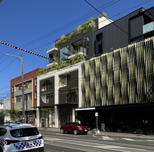
Figure 12 - Artist render showing the proposed development integrated with the existing development on the adjoining lots.
11.18 The proposal meets the requirements set out for the street wall that is no more that the mandatory 11 metres and matches the development at 141-143 Chapel Street.
11.19 The DDO21 provides a discretionary height of 16 metres or 5 storeys. It is considered that the additional storey resulting in a height of 20.9 metres to the top of the parapet is acceptable. While the two adjoining properties are lower than this development, there are a number of mixed-use developments with proximity of the site that have been developed up to 6 stories such as 126, 128 and 154 Chapel Street. While these properties are located within a different precinct of the DDO21, the 5 storey discretionary height controls are the same. The properties shown in figures 12 and 13 are located approximately125 metres south of the subject site. These sites also have an interface with fine grain residential properties to the rear.
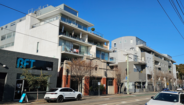
Figure 13 - 6 storey development to the south of the subject site on Chapel Street.
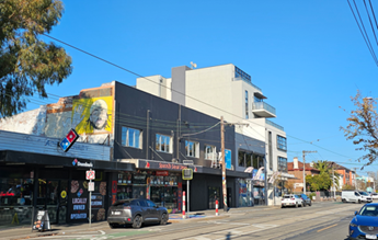
Figure 14 - Additional 6 storey development along Chapel Street.
11.20 Above the street wall, levels three and four have been setback by 3 metres. Level 5 is setback by between 4.7 and 5.1 metres due to the slightly angled front boundary. The design requirements allow a setback of 3 metres rather than 5 metres where the upper levels are distinctly different and visually recessive. The proposal achieves sufficient distinction through the use of varied materials on the upper three levels. While the darker cladding on the upper levels will be required to be lighter for ESD reasons, the upper levels will still present as recessive to the lower levels. The feature screening to the street wall façade with circular openings contrasts to the square liner design of the upper levels. Landscaping in planter boxes along the top of the street wall also provides a visual break between the street wall and upper levels.
11.21 The ground floor façade provides good activation of the street with a commercial tenancy occupying 10 metres of the 13.5 metre frontage. The majority of the façade comprises clear glazing providing direct views to the street and into the building from the street. The remaining 3.5 metres of the front of the site includes the residential entrance with clear views into the lobby towards the stairs and lift. A small section of the frontage contains the fire services cupboard which cannot be located elsewhere on the site. A condition is included within the officer recommendation that requires that the fire cupboard be reduced in size unless the fire authority demonstrates that this is not possible.
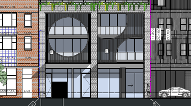
Figure 15 - Street elevation demonstrating glazed facade providing street activation.
Would the proposal result in unreasonable amenity impacts to the surrounding properties?
11.22 The proposal will not result in unreasonable off site amenity impacts. The key amenity impacts relate to daylight access, overshadowing, overlooking and visual bulk. These are discussed below.
Overshadowing
11.23 The proposal will reduce the amount of sunlight to the dwellings at 37, 39 and 41 Duke Street to the west of the subject site. However, the extent of overshadowing will not be unreasonable in the context of the area and the relevant planning controls.
11.24 The decision guidelines of the Commercial 1 Zone state that the responsible authority must consider the overlooking and overshadowing as a result of building or works affecting adjoining land in a General Residential Zone, Housing Choice and Transport Zone, Neighbourhood Residential Zone, Residential Growth Zone or Township Zone
11.25 Clause 58 is silent on overshadowing. This is because development of an apartment buildings in areas capable of accommodating such development should not be unreasonably constrained by shadow impacts on private open space. In Mirvac BTR Developments v Moreland CC [2022] VCAT 300 (22 March 2022) the Tribunal noted:
In relation to shadow impacts it is significant that Clause 58, … do not contain standards relating to overshadowing of adjacent properties. This reflects a recognition that the development of apartment buildings in precincts designated for such development should not be unduly prejudiced by the consideration of overshadowing impacts. The planning scheme contemplates a contextual analysis of a proposal’s amenity impacts to determine whether those impacts are acceptable.
11.26 The most impacted property would be 41 Duke Street. The rear section of this lot is used for dual car parking and secluded private open space (SPOS). The SPOS will be overshadowed between 9 and 10 am on 23 September. By 11 am there are no additional shadows cast on the property. While the proposal does add to the overshadowing, a significant amount of shadow is cast by the tall boundary fence of 41 Duke Street along the lane at the rear of the subject site. The fence which is more than 2.5 metres high casts shadows across the narrow lot. The area of secluded private open space at the rear of this site tappers down to a very narrow width due to the vehicle access provided to the area and the orientation of the lane.
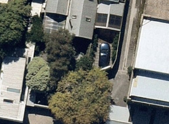
Figure 16 - rear private open space of Duke Street properties with 41 Duke with a car parked in the rear private open space.
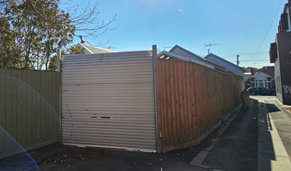
Figure 17 - Taller rear fence and vehicular access of lane to 41 Duke Street.
11.27 37 and 39 Duke Street also have their areas of SPOS overshadowed with 37 Duke Street receiving additional shadow before 10 am and 39 Duke Street receiving shadows between 9 am and just after 10 am. Overall it is considered that the extent of additional shadows is not unreasonable for properties that are adjacent to a major activity centre.
11.28 Additional shadows will also be cast onto the building at 147 Chapel Street. While there is a dwelling being renovated at the third floor of that building the shadows will not be cast on an area of private open space. While the proposal will impact sunlight access to windows at 147 Chapel Street, the Planning Scheme purposely does not seek protect sunlight to habitable room windows on adjoining sites in activity centres. To do so would result in constraints that would prevent achievement of higher density sought in major activity centres.
Daylight access to 147 Chapel Street
11.29 Standard D14 (Building Setback objectives) of Clause 58 relates to ensuring setbacks provide adequate daylight for new dwellings, not existing dwellings. The standard is about buildings designed to ensure daylight is provided from within their own site, and not rely on daylight access from adjoining private land.
11.30 While a proposed on-boundary three storey high wall could be acceptable to the boundary with 147 Chapel Street, the development provides daylight access via light courts provided on both side elevations. On the south side of the building a light court is provided alongside the light court of 147 Chapel Street. The light court is larger than 147 Chapel Street. The combined light courts benefit 147 Chapel Street occupants along with the future occupants of the proposed development.
Overlooking
11.31 The development will not result in unreasonable overlooking subject to conditions.
11.32 The proposal has potential to allow overlooking to the residential properties to the west. These properties which front Duke Street have areas of SPOS that are adjacent to the rear of the proposed development. To mitigate this matter that development has incorporated privacy screening to a height of 1.7 metres above the finished floor levels of each of the balconies. These screens are appropriate and ensure that there will not be any overlooking to the properties.
11.33 On the south side of the development there are potential views into the habitable room windows of 147 Chapel Street. The resident (objector) at this site has identified that the second level is used as a dwelling.
11.34 A condition is included within the officer recommendation that requires the provision of obscure glass or similar to a height of 1.7 metres above finished floor level of the south facing bedrooms on levels 2, 3 and 4 to avoid direct views into the habitable room windows of the dwelling at level three at 147 Chapel Street. The use of obscure glass will ensure that the daylight to these apartments is not impacted unreasonably. Overlooking measures is not required for the first floor as it sits below the level of the dwelling.
Would the proposal provide an acceptable level of internal amenity for residents?
11.35 An application for the construction of an apartment building within the Commercial 1 Zone is required to be assessed against the objectives, standards and decision guidelines of Clause 58.
11.36 A Clause 58 assessment is included as an attachment to this report. The proposal provides an acceptable level of compliance with the internal amenity objectives of Clause 58, particularly functional layout of bedrooms and living rooms, daylight to habitable rooms, natural ventilation and private open space.
Accessibility Objective – Clause 58.05-1
11.37 The development meets the standards and objective of this clause which is to ensure the design of dwellings meets the needs of people with limited mobility.
11.38 16 of the 20 (75%) apartments meet the accessibility standards in relation to door openings, clear access paths and bathroom access and design. The standard requires that 50% achieve compliance.
Private Open Space objective – Clause 58.05-3
11.39 The development meets the objective of this clause which is to provide adequate private open space for the reasonable recreation and service needs of residents.
11.40 All apartments are provided with an appropriate area of private open space. The private open space is provided as balconies with direct access from a living room. While a 5 of the balconies are between 100- 300mm short of the required minimum dimension of 2 metres, these balconies make up for the short fall by providing an area of greater than 8 square metres as required by the standard.
11.41 The development also provides a communal roof terrace with an area of 129 sqm which is accessible to all residents of the building. The communal space exceeds the area required under Clause 58.03-2 Communal open space objective which requires 80 square metres. The space incorporates perimeter landscaping. A condition is included in the officer recommendation that required the plans to include seating and other facilities for users such as a BBQ.
Functional layout objective – Clause 58.07-1
11.42 The developments meet the standards and objective of the above clause for both bedrooms and living rooms which is to ensure dwellings provide functional areas that meet the needs of residents.
11.43 All bedrooms and living rooms are provided with the minimum dimensions required by this standard.
Windows objective – Clause 58.07-3
11.44 The development meets the standards and objective of the above clause which is to allow adequate daylight into new habitable room windows.
11.45 All living rooms have a window in an external wall of the building. Bedrooms of the apartments have a window to one of the light courts on the north or south elevation.
11.46 The bedrooms facing the light courts at the lower levels will not receive as much daylight as the upper levels.
11.47 Plans submitted after the application was advertised provided an increased area of light court of the northern facing bedrooms opposite the existing wall on boundary. Large windows are also provided to all bedrooms to maximise light penetration.
11.48 The proposal was reviewed by Councils ESD officers who supported the proposal and the amount of light to bedrooms.
Natural Ventilation objective – Clause 58.07-4
11.49 The development meets the standards and objective of this clause which is to encourage natural ventilation of dwellings and to allow occupants to effectively manage natural ventilation of dwellings.
11.50 All of the apartments provide appropriate cross ventilation with breeze paths of more than 5 metres and less than 18 metres on different orientations of the building.
Does the proposal appropriately respond to the Heritage Overlay?
11.51 The proposed development is an appropriate response to the heritage significance of the subject site and neighbouring properties.
11.52 The subject site is located within the heritage overlay – schedule 07 ‘St Kilda, Elwood, Balaclava, Ripponlea’. The site is ungraded within the precinct. The construction of proposed development requires the demolition of all buildings on the site. The site currently contains a single storey commercial building with an area of car parking at the rear. The building is constructed to the frontage of the site with a narrow eave along verandah along the frontage. The building has not been in use for a number of years and tall hoarding boards have been erected along the front of the site to Chapel Street.
Demolition
11.53 The removal of the existing buildings at the site is acceptable as they are ungraded and do not provide any contribution to the heritage precinct. Councils’ heritage advisor supports the demolition of the buildings. The proposal is not inconsistent with Clause 15.03-1L Heritage Policy which only seeks to discourage the complete demolition significant or contributory buildings.
New works
11.54 The proposed development provides and appropriate response to the heritage policy. Clause 15.03-1 supports new buildings that respect and complement significant and Contributory buildings in relation to form, scale, massing, siting, details and materiality.
11.55 The development will not have an unreasonable impact on the significance of the heritage building at 147 Chapel Street. Views of the front of the building will not be obscured by the proposed development. While the proposed building is two storeys taller than 147 Chapel Street the recessing of the levels above the street wall will ensure that the development will not dominate the streetscape. The proposed street wall is consistent with the DDO21 and is similar in height to the front facade of 147 Chapel Street.
11.56 The side wall on boundary of the proposed development is to be concrete. This is typical of boundary wall on multistorey developments. The natural grey concrete finish is a subtle and neutral colour that will not detract from the red brick finish of 147 Chapel Street.
11.57 Council heritage advisor was satisfied that the proposed building would not have a negative impact on the adjoining building.
Does the proposal appropriately respond to the Special Building Overlay?
11.58 The subject site is located within an area affected by The Special Building Overlay – Schedule 1. This schedule relates to the Melbourne Water Main Drain.
11.59 The purpose of the SBO1 is
· To identify land in urban areas liable to inundation by overland flows from the urban drainage system as determined by, or in consultation with, the floodplain management authority.
· To ensure that development maintains the free passage and temporary storage of floodwaters, minimises flood damage, is compatible with the flood hazard and local drainage conditions and will not cause any significant rise in flood level or flow velocity.
· To protect water quality and waterways as natural resources by managing urban stormwater, protecting water supply catchment areas, and managing saline discharges to minimise the risks to the environmental quality of water and groundwater.
11.60 An application under this overlay is required to be referred to the relevant floodplain management authority (Melbourne Water). Melbourne Water did not object to the proposal subject to a range of condition that have been included in the officer recommendation.
11.61 The conditions provided require changes to the plans to ensure that any potential flood impacts to the site can be appropriately mitigated. These changes encompass matters such as:
· raising finished floor levels of ground floor areas to a level that is above the applicable flood level of the site.
· Provision of flood resistant materials for any wall below the flood level, and
· Ensuring electrical installations within the areas subject to flooding are in accordance with the relevant authority’s standards.
11.62 The changes required by Melbourne Water will readily be able to be incorporated into the development without significant change to the proposal. It is considered that subject to the conditions required by Melbourne Water that the proposal appropriately responds to the potential floor risk at the site.
Are the proposed car and bicycle parking provision and access arrangements acceptable?
11.63 The development provides an appropriate number of car parking spaces. The 7-car space reduction to the statutory car parking rate is acceptable
11.64 The table below outlines the spaces provided, the statutory rate of Clause 52.06 and the short fall.
|
Proposal |
Rate |
Statutory rate |
Total required |
Spaces provided |
Reduction sought |
|
20 two bedroom apartments |
1 spaces per one or two bedroom apartment |
20 |
23 |
16 residential spaces |
7 spaces (4 residential, 3 office) |
|
106 sqm office space |
3 spaces to each 100sqm of leasable floor area |
3 |
11.65 No visitor spaces are required as the site is located within the Principal Public Transport Network.
11.66 A permit is required to reduce the number of car parking spaces. Clause 52.06-7 sets out the matters Council must consider before granting a such a permit. These matters include;
· A car parking demand assessment that assesses the car parking demand likely to be generated by the proposal based on matters including the availability of public transport nearby; the convenience of pedestrian and cyclist access to the land.
· The provision of bicycle parking for cyclists and the anticipated car ownership rates of occupants of the land.
· Relevant planning policy; and
· Access to alternative transport modes to and from the land.
11.67 To the support this, Clause 18.02-4L-01 – Car parking provision contemplates it is appropriate to “support support a reduction in the required number of car parking spaces where the following are met”:
· The site is located within a short walking distance to high frequency public transport; or the site is located within Activity Centres or areas immediately adjacent to Activity Centres.
· The provision of sustainable transport infrastructure / initiatives, including higher quantities of bicycle parking can reduce the demand for parking through increased use of alternative modes of transport: walking, cycling, and public transport.
· The development or use is unlikely to result in unreasonable adverse impacts on existing on-street parking.
11.68 A reduction in car parking is acceptable because the site has excellent access to public transport with the following routes within walking distance of the site:
· Tram routes 3, 3a, 16, along Carlisle Street, 78 along Chapel Street and Bus route 623 along St Kilda Road
· Balaclava Railway station is located just over 300 metres to the east of the site on Carlisle Street.
11.69 The site is within 200 metres of two major supermarkets and is centrally located within the Chapel Street and Carlisle Street shopping strip that makes up the Carlisle Street Major Activity Centre. This proximity allows future residents to meet all their shopping and service needs without relying on a car.
11.70 Although the Scheme requires the provision of 6 bicycle spaces, a total of 26 spaces are provided. The provision for bicycle parking combined with the various bicycle routes nearby, including on-road bicycle lanes, make the use of bicycles a viable alternative to a car in this location.
11.71 A reduced car parking provision combined with generous bicycle parking and proximity to public transport is supported by policy that seeks development that promotes alternative modes of transport and reduces reliance on private car travel.
11.72 ABS census data of car ownership rates in St Kilda in the Traffic Impact Assessment (TIA) provided by the applicant shows that approximately 20% of residents in two-bedroom apartments do not own a car. Applying this rate to the 20 apartments would result in a demand of 16 spaces which is what is provided.
11.73 Reduced provision for resident car parking can result in lower rates of private vehicle ownership. This has benefits including reduced traffic congestion and the environmental and health benefits associated with increased use of walking, cycling and public transport. These outcomes are supported in local policy.
11.74 Car parking is restricted within the surrounding streets to 1 hour between 8am and 6pm and permit zones. While short term parking is available, residents will not have access to long term parking or parking permits. Residents without an allocated car space will be unlikely to own cars given that car parking will not be available. The restricted car parking in the area will reduce the impact of the car parking reduction on existing residents in the area.
Traffic impacts
11.75 The proposal will not have an unreasonable impact on the traffic in local area.
11.76 The site is located on Chapel Street and is close to the intersection of Carlisle Street. St Kilda Road is located approximately 300 metres to the west. Traffic generated by the proposal will be able to readily access these roads and will not result in unacceptable traffic congestion.
11.77 The Traffic Impact assessment provided in support of the application calculated that there would be approximately 6 traffic movements generated by the proposal during peak times. As the car stacker entrance is only 20 metres from Duke Street this will not result in an unreasonable impact on the current users of the lane.
11.78 While there may occasionally be multiple cars using the laneway at the rear of the site, the lane is short and waiting times for cars entering or exiting the lane from Duke Street or from any of the sites serviced by the lane would be minimal.
11.79 The rear lane is already used by many properties as a thoroughfare from the rear of properties with an abuttal to Duke Street and Chapel Street. The lane is short and has acceptable clearance for pedestrian sightlines.
Design of car and bicycle parking and vehicle access
11.80 Car parking is provided at the rear of the building in a 16-car space stacker system. Access to the stacker is off the rear lane. While the lane is only single car width, the entry to the stacker is setback 7 metres from the neighbouring property boundary fence on the west side of the lane. This setback provides adequate space for cars to be able to enter and exit the stacker system in a safe and efficient manner.
11.81 While Councils traffic engineer expressed some concern with the available space to accommodate the stacker system, the development plans show that the stacker readily fits within the space.
11.82 All vehicles will be able to enter the car stacker in a forwards direction and reverse out so that they can exit the lane onto Duke Street in a forwards direction.
11.83 Bicycle parking spaces have been provided in a mix of horizontal and vertical wall mounted rails. Access to the bike storage areas is via 1.5 metres wide passages.
Are the waste management arrangements acceptable?
11.84 The proposed development will be able to effectively manage the collection, storage and disposal of waste generated at the site.
11.85 A waste management plan (WMP) was submitted with the application. The WMP provided details of waste volumes generated by the users of the building as well as the storage of the waste additional information was required by Councils Waste management team. Conditions are included within the officer recommendation that will provide the detail on the plans that is missing.
11.86 The bins are stored at the rear of the site and will be moved to the Duke Street roadside for collection by a private contractor. The contractor will be responsible for moving the bins to the street and will ensure that the laneway is not blocked by the waste collection truck.
11.87 The waste collection will be undertaken in a manner that is similar to the mixed use building at 141-143 Chapel Street next door.
11.88 Councils Waste Management Officer is satisfied that the matters requiring clarification can be resolved through conditions.
How does the proposal address potentially contaminated land?
11.89 The subject site is located within an area covered by the Environmental Audit Overlay. The purpose of this overlay is to ensure that potentially contaminated land is suitable for a use which could be significantly adversely affected by any contamination.
11.90 The overlay requires that before a sensitive use (residential use) commences or before the construction or carrying out of buildings and works in association with these uses commences:
· A preliminary risk screen assessment statement in accordance with the Environment Protection Act 2017 must be issued stating that an environmental audit is not required for the use or the proposed use; or
· An environmental audit statement under Part 8.3 of the Environment Protection Act 2017 must be issued stating that the land is suitable for the use or proposed use; or
· A certificate of environmental audit must be issued for the land in accordance with Part IXD of the Environment Protection Act 1970; or
· A statement of environmental audit must be issued for the land in accordance with Part IXD of the Environment Protection Act 1970 stating that the environmental conditions of the land are suitable for the use or proposed use.
11.91 Conditions are included within the officer recommendation requiring that the above actions are undertaken, as appropriate, prior to the commencement of the development.
12. OFFICER material OR general INTEREST
12.1 No officers involved in the preparation of this report has declared a material or general interest in the matter.
13. CONCLUSION
13.1 Clause 71.02-3 of the planning scheme requires the decision maker to integrate the range of policies relevant to the issues to be determined and balance the positive and negative environmental, social, and economic impacts of the proposal in favour of net community benefit and sustainable development. When considering net community benefit, fair and orderly planning is key; the interests of present and future Victorians must be balanced; and the test is one of acceptability.
13.2 The proposal:
· Is consistent with the strategic direction of the Port Phillip Planning Scheme.
· Will result in an increase is residential density in an area that is well serviced by jobs, services and public transport.
· Provides an acceptable response to context and a commercial street activation that will contribute to the public realm.
· Provides an appropriate response to the design objectives and requirements of the Design and Development Overlay.
· Provides an acceptable response to the Heritage Overlay and Special Building Overlay.
· Provides an acceptable standard of internal amenity for future residents.
· Provides car parking at an acceptable rate given the sites location and planning policy aimed at reducing reliance on private car ownership.
· Will be able to provide for waste collection facilities that are acceptable subject to conditions.
13.3 On balance, is considered the proposal is acceptable subject to conditions of the officer recommendation to address the issues of concern raised in this report and will result in a net community benefit.
13.4 It is recommended that Council issues a Notice of Decision to Grant a Planning Permit.
|
ATTACHMENTS |
1. Decision plans. 2. Revision C Decision Plans 3. Clause 58 Assessment 4. Zoning Map |
Planning Committee
23 July 2025
|
6.3 |
204 Princes Street, Port Melbourne - PDPL/00535/2024 |
|
location/address: |
204 PRINCES STREET PORT MELBOURNE |
|
Executive Member: |
Brian Tee, General Manager, City Growth and Development |
|
Manager |
Paul wood, manager city development |
|
PREPARED BY: |
Vivian Liu, Senior Urban Planner |
1. PURPOSE
1.1 To consider and determine Planning Application PDPL/00535/2024 for the construction of two three-storey dwellings in a General Residential Zone and the reduction of car parking requirements of Clause 52.06.
2. EXECUTIVE SUMMARY
|
Ward: |
Montague |
|
Trigger for
determination |
Councillor call in |
|
ApplicATION NO: |
PDPL/00535/2024 |
|
Applicant: |
ASK Planning Services Pty Ltd |
|
Existing use: |
Residential |
|
Abutting uses: |
Residential |
|
Zoning: |
General Residential Zone – Schedule 1 |
|
Overlays: |
No Overlays |
|
Statutory time
remaining for |
Expired |
2.1 Planning permit application PDPL/00535/2024 was received by Council on 19 September 2024 and seeks approval for construction of two three-storey dwellings and a car parking reduction at 204 Princes Street, Port Melbourne. The application proposes to demolish the existing one storey dwelling on the site. The proposed dwellings each include 3 bedrooms, a roof terrace, and 1 car park in the ground level garages to the rear, accessed from Allen Place.
2.2 The proposal requires the provision of 4 car parking spaces to satisfy Clause 52.06 (Car Parking). Two spaces are provided, 1 to each dwelling. Therefore, the application seeks a waiver of 2 spaces.
2.3 The proposal includes the demolition of the existing dwelling that currently occupies the site. No planning permit is required for demolition.
2.4 The subject site has a front boundary of 11.65m to Princes Street and a depth of 14m on its north-east side, the site has a splayed south-west boundary to Allen Place. The site has an area of 179sqm and currently contains a single storey dwelling fronting Princes Street.
2.5 The land is within a General Residential Zone – Schedule 1 (GRZ1). There are no overlays on the site.
2.6 The planning permit triggers for the application are:
· To construct two or more dwellings on a lot pursuant to Clause 32.08-7 of the General Residential Zone.
· To reduce the number of car parking spaces required under Clause 52.06-5 (Car Parking)
2.7 The application was advertised in February 2025 and received 13 objections. Key concerns raised include neighbourhood character, lack of landscaping and open space, amenity impacts, traffic concerns, lighting and safety, and construction impacts.
2.8 A consultation meeting was held on 15 April 2025. The meeting was attended by 3 Councillors, the applicant, objectors and planning officers.
2.9 Following the consultation meeting the permit applicant lodged amended plans pursuant to Section 57A of the Planning and Environment Act 1987 on 9 May 2025.
2.10 The amended plans include the following changes:
· The front setback of the second floor of Dwelling 2 has been increased from 1.6m to 1.9m to match the setback of 208 Princes Street.
· A 482mm offset from the rear boundary at second floor (from 0m) has been introduced.
· The first and second floor walls associated with the living room and master bedroom of Dwelling 1 have been setback from the laneway (south-west boundary) by 410mm (from 0m).
· 1.7m high screens material on the roof terrace have been replaced with opaque laminated glass from aluminium screening to limit overlooking and acoustic impacts.
· The material applied to the upper floor north-east facing wall adjacent to 208 Princes has been changed to a metal cladding as opposed to light coloured brick.
· A 1.8m dimension has been added to the top level highlight window on the south elevation.
· Air conditioner condenser units on the roof top have been reduced in size to represent their true size and have been further recessed to reduce visibility and noise.
· The “rounding” of Bed 2 corner has been increased to have a radius of 1200mm.
2.11 The amended plans were informally advertised to all objectors. No objections were withdrawn.
2.12 Because the amended plans were lodged after 6 March 2025 the application needs to be assessed under the revised Clause 55 assessment introduced under Planning Scheme Amendment VC267. Planning Scheme amendment VC267 has introduced a streamlined assessment of low-rise residential development where it is limited to the objectives, standards, and decision guidelines of Clause 55. The new code introduces a deemed to comply assessment pathway to support faster decisions and greater certainty for townhouses and apartment buildings up to three storeys at clause 55 of all planning schemes.
2.13 The proposal is acceptable for the following reasons:
· The proposed reduction in car parking aligns with the strategic direction in Clause 18.02-4L-01 which supports car parking reduction where a site is located within a short walking distance to high frequency public transport or immediately adjacent to activity centres. The subject site measures favourably against both these criteria, being located approximately 215m from the Bay Street Major Activity Centre and 200m from the light railway line.
· The proposal satisfies the neighbourhood character and amenity objectives of Clause 55 where it satisfies most of the deem to comply standards. Variations are sought to side and rear setbacks, walls on boundaries, site coverage, overshadowing, and overlooking but these are considered acceptable given the site's corner location, laneway interfaces, and surrounding built form. Overshadowing affects only a small area during morning hours, and overlooking is mitigated through proposed screening, with conditions recommended to ensure compliance. Overall, the design responds appropriately to its urban context while maintaining residential amenity.
· The proposal offers strong internal amenity and sustainability, with spacious living areas, over 34sqm of private open space per dwelling, and only a negligible variation to entry cover. It meets all sustainability standards, including stormwater management with two 2,000-litre rainwater tanks and a high STORM rating of 168%, ensuring a comfortable and environmentally responsible design.
· The provision of 2 car spaces (1 for each dwelling) is acceptable given proximity to numerous modes of public transport and location within the Principal Public Transport Network (PPTN). Each dwelling is also provided with space within the garage for bicycle storage. The small site size makes achieving on-site parking difficult. Furthermore, planning policy supports reducing reliance on private car ownership.
2.14 The concerns raised by the objectors are acknowledged and discussed within this report.
2.15 The proposal is recommended for approval, subject to the conditions below.
|
3.1 That the Responsible Authority, having caused the application to be advertised and having received and noted the objections, issue a Notice of Decision to Grant a Permit 3.2 That a Notice of Decision to Grant a Permit be issued subject to the following permissions:
3.3 That the decision be issued as follows: 1 Before the development starts, amended plans to the satisfaction of the Responsible Authority must be submitted to and approved by the Responsible Authority. When approved, the plans will be endorsed and will then form part of the permit. The plans must be drawn to scale with dimensions and an electronic copy must be provided. The plans must be generally in accordance with the plans submitted with the application (identified as TP00 – TP23 Revision B, job number eA2415, dated Aug 2024, received by Council on 08/01/2024, prepared by Elevation7) but modified to show: a) External lighting of the areas set aside for car parking and driveways must be designed, baffled and located to the satisfaction of the Responsible Authority to prevent any adverse effect on adjoining land b) A minimum 2m x 2.5m corner splay provided at the south-west corner. Any structures or vegetation within the splay must not exceed 0.9m in height c) Dwelling 1’s first floor dining room windows as obscure glazed d) Details of the 1.7m high timber screening on the second floor terrace to demonstrate compliance with Clause 55.04-4 Standard B4-4 Overlooking e) A section diagram demonstrating Dwelling 2’s terrace is in compliance with Clause 55.04-4 Standard B4-4 Overlooking as it relates to overlooking to the northeast f) The driveway gradients to the garages in compliance with Clause 52.06 Design Standard 3: Gradients g) Water Efficient Landscaping – An updated landscape plan is required with appropriate plantings in support of this h) ‘Retractable paraline’ on terrace floor plan to include the word ‘clothesline’ for clarity i) External Lighting – Motion detector controlled j) Internal Lighting - illumination density of 4W/sqm or less k) Double Glazing marked on plans for Unit 2, and triple-glazed for Unit 1 l) External Shading to north, east and west elevations m) FOGO bins on plans (with volume as per any accompanying and approved waste report) n) Tap and waste on each dwelling’s courtyard/terrace o) The upper most level to be a light colour p) Both kitchen windows of Dwelling 2 to be openable in to demonstrate compliance with Clause 55.03-10 Standard B3-10 Natural Ventilation q) The external material colour of the second floor addition as a lighter colour such as cream or similar.
No Alterations 2 The layout of the site and the size, levels, design and location of buildings and works shown on the endorsed plans must not be modified for any reason without the prior written consent of the Responsible Authority. Satisfactory Continuation and Completion 3 Once the development has started it must be continued and completed to the satisfaction of the Responsible Authority. Privacy Screening Must Be Installed 4 Prior to the issue of any Certificate of Occupancy or Certificate of Final Inspection for the development approved by this permit the installation of privacy screens must be undertaken in accordance with the endorsed plans. The privacy screens must be maintained thereafter to the satisfaction of the Responsible Authority. Walls on or Facing the Boundary 5 Prior to the issue of any Certificate of Occupancy or Certificate of Final Inspection for the development approved by this permit all new or extended walls on or facing the boundary of adjoining properties and/or a laneway must be cleaned and finished to a uniform standard to the satisfaction of the Responsible Authority. Unpainted or unrendered masonry walls must have all excess mortar removed from the joints and face and all joints must be tooled or pointed also to the satisfaction of the Responsible Authority. Painted or rendered or bagged walls must be finished to a uniform standard to the satisfaction of the Responsible Authority. No Equipment or Services 6 Any plant, equipment or domestic services visible from the primary street (other than a lane) or public park must be located and visually screened to the satisfaction of the Responsible Authority. Driveway to be Kept Clear 7 Once the development has been completed, the driveways must be kept clear of any obstruction to always maintain free vehicular passage to both dwellings. Vehicle Crossing 8 Prior to the issue of any Certificate of Occupancy or Certificate of Final Inspection for the development approved by this permit, vehicle all crossings must be constructed in accordance with Council’s current Vehicle Crossing Guidelines and standard drawings to the satisfaction of the Responsible Authority. All redundant crossings must be removed and the footpath, naturestrip, kerb and road reinstated as necessary at the cost of the applicant/owner and to the satisfaction of the Responsible Authority. Water Sensitive Urban Design 9 Prior to the endorsement of plans under Condition 1 of this permit, a Water Sensitive Urban Design (Stormwater Management) Report must be submitted to the Responsible Authority in electronic format. When approved, the Water Sensitive Urban Design Report will be endorsed and will then form part of this permit. The report must: a) Demonstrate how the development meets the water quality performance objectives as set out in the Urban Stormwater – Best Practice Environmental Management Guidelines (CSIRO, 1999) or its updated equivalent. This must include: i. An updated and accurate STORM report including all impervious areas, treated and untreated. ii. The Site Layout Plan updated to include access hatches shown to both RWT’s, along with connection details for stormwater re-use. Updated Sustainable Design Assessment 10 Prior to plans being endorsed under condition 1 of this permit, an updated Sustainable Design Assessment (SDA) must be submitted to and approved by the Responsible Authority. The updated SDA must be generally in accordance with the SDA submitted with the application titled Sustainable Design Assessment, dated 25 November 2024, authored by Elevation7, but modified to address the following; a) The BESS updated to include solar P/V as per the roof plan shows. b) The BESS improved in the category of Water to an acceptable score. c) Statements made in the SDA that include recycling of construction wastes, use of recycled materials with FSC/PEFC accreditation, sustainably sourced timber where possible and cement to be supplemented with Supplementary Cementing Materials (SCM) concretes, to be formalised by being noted on the plans. Upon addressing/finalising matters raised below, the report to be ‘published’ to formalise. Where alternative ESD initiatives are proposed to those specified in this condition, the Responsible Authority may vary the requirements of this condition at its discretion, subject to the development achieving equivalent (or greater) ESD outcomes. When approved, the updated SDA will be endorsed and will then form part of this permit. The ESD initiatives in the endorsed SDA must be fully implemented and must be maintained throughout the operational life of the development to the satisfaction of the Responsible Authority. Incorporation of Water Sensitive Urban Design Measures 11 Prior to the issue of any Certificate of Occupancy or Certificate of Final Inspection for the development approved by this permit, the provisions, recommendations and requirements of the endorsed Water Sensitive Urban Design Report must be implemented and complied with to the satisfaction of the Responsible Authority. Construction Management Water Sensitive Urban Design 12 The developer must ensure that throughout the construction of the building(s) and construction and carrying out of works allowed by this permit: a) No water containing oil, foam, grease, scum or litter will be discharged to the stormwater drainage system from the site. b) All stored wastes are kept in designated areas or covered containers that prevent escape into the stormwater system. c) The amount of mud, dirt, sand, soil, clay or stones deposited by vehicles on the abutting roads is minimised when vehicles are leaving the site. d) No mud, dirt, sand, soil, clay or stones are washed into, or are allowed to enter the stormwater drainage system. e) The site is developed and managed to minimise the risks of stormwater pollution through the contamination of run-off by chemicals, sediments, animal wastes or gross pollutants in accordance with currently accepted best practice. No Reticulated Gas 13 Any new dwelling allowed by this permit must not be connected to a reticulated gas service (within the meaning of Clause 53.03 of the Port Phillip Planning Scheme). This condition continues to have force and effect after the development authorised by this permit has been completed. Time for Starting and Completion 14 This permit will expire if one of the following circumstances applies: a) The development is not started within two years of the date of the permit. b) The development is not completed within four years of the date of the permit. The Responsible Authority may extend the periods referred to if a request is made in writing: · Before or within 6 months after the permit expiry date, where the development allowed by this permit has not yet started; and · Within 12 months after the permit expiry date, where the development allowed by the permit has lawfully started before the permit expires. |
||||||||
4. RELEVANT BACKGROUND
There is no relevant history or background for this application.
5. PROPOSAL
5.1 The plans which are the subject of this report are the 57A amended plans received by Council on 9 May 2025, dated 29.04.2025, prepared by Elevation and numbered TP00, TP01, TP02, TP03, TP04, TP05, TP06, TP07, TP08, TP09, TP10, TP11, TP12 TP13, TP14, TP15, TP16, TP17, TP18 TP19, TP20, TP21 and TP23 all revision C.
5.2 The application is for the construction of two three-storey dwellings with roof terraces and carparking off Allen Place. The dwellings will each comprise of 3 bedrooms, and a single garage. Garages at the rear of the site, located off Allen Place with primary frontage to Princes Street.
![]()
Figure 1. Artist render of the
proposed development
5.3 Dwelling 1 includes two ground-level bedrooms, one bathroom, and a garage. The southwest boundary adjoins Allen Place. The first floor comprises open-plan kitchen, dining, and living areas with a balcony on the front boundary. The second floor includes a main bedroom, a kitchenette, and a terrace with roof garden along the southwest side. A 26m² roof terrace with planters, and services are proposed on the roof. The roof terrace is screened to 1.7m on the west and south elevations.
5.4 Dwelling 2 includes one ground-level bedrooms, one bathroom, and a garage. The northeast boundary adjoins 208 Princes Street. The first floor comprises open-plan kitchen, dining, and living areas with a balcony facing Princes Street. The second floor includes a main bedroom and a second bedroom. A 25m² roof terrace with planters, and services are proposed on the roof. The roof terrace is screened to 1.7m on the south elevations.
5.5 The dwellings are designed to integrate with the surrounding urban context, featuring contemporary architectural elements. The proposal is 3 storeys and reaches a maximum height of 8.8 metres, with 94% site coverage and 21% of the site available for stormwater absorption. The façade materials are contemporary and include light brick, concrete render, interlock cladding, and aluminium battens.
5.6 Further particulars of the proposal are outlined below.
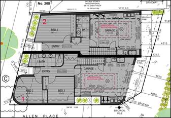
Figure 2. Ground floor plan
![]()
Figure 3. First floor plan
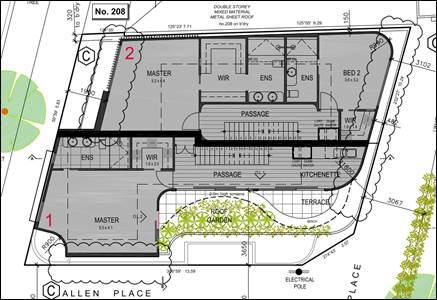
Figure 4. Second floor plan
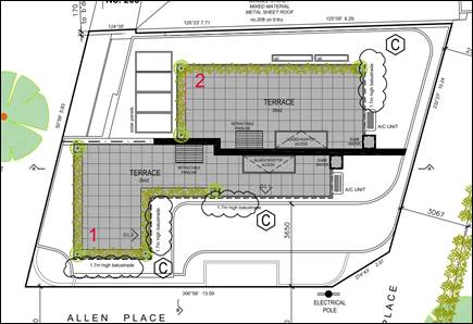
Figure 5. Roof floor plan
5.7 A full set of the development plans is at Attachment 1.
6. SUBJECT SITE AND SURROUNDS
|
|
Description of Site and Surrounds |
|
Site Area |
179 sqm |
|
Existing building & site conditions |
The site is on a corner lot – fronting Princes Street. It also has a southern (side) and eastern (rear) interface to Allen Place. A single storey infill brick dwelling with a flat roof occupies the site. It has a low brick and steel front fence. The site has access from Princes Street and Allen Place. There is no car parking within the site. The site is irregular in shape with a 11.65m front to Princes Street, and a depth of 15.8m to Allen Place. The irregularity of the lot relates to the splay along the southern corner of the site in relation to the junction of laneways of Allen Place.
Figure 6. Subject site. Source: Council Officer, 22 October 2024
Figure 7. Rear of subject site, Allen Place. Source: Council Officer, 9 April 2025 |
|
Surrounds/neighbourhood character |
The character of Princes Street is diverse in nature comprising a mixture of single storey Victorian cottages through to two and three storey contemporary development. This is reflective of the two different residential zones and the Heritage Overlay which covers the north-east section of Princes Street, as detailed within the below Council mapping.
Figure 8. Intramaps: Zone and Overlay, subject site identified in red.
Figure 9. Southwest of the subject site (L-R 187, 189, 191, 193, 197 Princes Street). Source: Council Officer, 9 April 2025
Figure 10. Southwest of the subject site (L-R 176, 172, 170 Princes Street). Source: Council Officer, 9 April 2025
Figure 11. Northeast of the subject site (230 Princes Street). Source: Council Officer, 9 April 2025
Figure 12. Northeast of the subject site (237, 239, 239A Princes Street). Source: Council Officer, 9 April 2025 The southwestern end of Princes Street, including the subject site and adjoining site of 208 Princes Street, is within the General Residential Zone. The northeastern end of Princes Street is within the Neighbourhood Residential Zone and is covered by the Heritage Overlay. The area is characterised by residential dwellings with small or no front setbacks. Some first floor levels are located on the front boundary, with third levels generally recessed, however still visible from the street. Many of the sites have no or limited side setbacks, including at upper levels. There are several dwellings with balconies facing Princes Street, and roof terraces.
Figure 13. Subject site and adjoining sites (208 Princes St on Left, 200 Princes Street on Right). Source: Council Officer, 22 October 2024
The site has the following interfaces: To the southwest of the site is a small laneway known as Allen Place. Beyond the laneway is 200 Princes Street which is developed with a double storey dwelling that fronts Princes Street with minimal setbacks. The front setback includes car access. It has a double storey wall on boundary for a portion of Allen Place. The rear portion of the interface with Allen Place has a ground floor SPOS.
Figure 14. Southwest of the subject site (L-R 200 Princes St, 198 Princes Street). Source: Council Officer, 9 April 2025
To the northeast of the site is 208 Princes Street. It is developed with a dwelling that is single storey at the front, and graduates to double storey at the rear of the site. It shares a wall on the boundary with the subject site for the entire length of the subject site. It has a 1.89m front setback to Princes Street.
Figure 15. Northeast of the subject site (L-R 216 Princes St, 208 Princes Street). Source: Council Officer, 9 April 2025
To the rear of the site is the rear part of the Allen Place laneway. Beyond the Laneway is 6 Allen Place which is vacant block of land. There is a current planning permit application (PDPL/00252/2024) which proposes the construction of two dwellings on a lot and reduction of the car parking requirement. One of the dwellings would be three storeys with a maximum height of 10.7m, both dwellings front Allen Place. No determination has been made for the application at the date of this report. |
|
Aerial photo |
Figure 16. Aerial photograph of subject site (red marker) and surrounds. Source: Nearmap April 2025 |
7. Permit Triggers
The following zone and controls apply to the site, with planning permission required as described. A Zoning Map is contained at Attachment 2.
|
Zone or Overlay |
Why is a permit required? |
|
Clause 32.08-7 General Residential Zone Schedule 1 (GRZ1) |
General Residential Zone states a permit is required to: · Construct two or more dwellings on a lot in a General Residential Zone A permit is required to construct or extend a front fence within 3 metres of a street if: · The fence is associated with 2 or more dwellings on a lot or a residential building, and · The fence exceeds the maximum height specified in Clause 55.02-8. The front fence/planter box to Dwelling No. 2 is 900m in height, no permit is required for the fence. A development must meet the requirements of Clause 55. This does not apply to a development of four or more storeys, excluding a basement. |
|
Clause 52.06-3 Car Parking |
The Car Parking Provisions states a permit is required to: · Reduce (including reduce to zero) the number of car parking spaces required under Clause 52.06-5 |
8. PLANNING SCHEME PROVISIONS
8.1 State Planning Policy Frameworks (SPPF)
The following State Planning Policies are relevant to this application:
Clause 18.02-4L-01 Car parking
8.2 Other relevant provisions
Clause 52.06 Car Parking
Clause 53.03 Residential Reticulated Gas Service Connection
Clause 53.18 Stormwater Management in Urban Development
Clause 55 Two or More Dwellings on a Lot and Residential Buildings
Clause 62 General Exemptions
Clause 65 Decision Guidelines
Clause 71 Operation of this Planning Scheme
8.3 Relevant Planning Scheme Amendment/s
Planning Scheme Amendment VC267
Planning Scheme Amendment VC267 (Gazetted 6 March 2025) introduced updated planning assessment provisions for residential development across Victoria, focusing on the “Townhouse and Low-rise Code” (Clause 55) and “4 Storey Apartment Standards” (Clause 57). The reforms aim to simplify and expedite planning for developments up to three storeys (Clause 55) and four-storey apartments (Clause 57).
For developments of two or more dwellings up to three storeys, Clause 55 now offers a deemed-to-comply assessment pathway: if all applicable standards are met, the proposal is considered compliant and cannot be refused on those grounds. In such cases, third-party appeal rights (objector appeals) do not apply.
Another significant update is that the responsible authority is no longer required to consider the Municipal Planning Strategy, Planning Policy Framework, zone purposes, Clause 65, or other decision guidelines—unless a relevant Clause 55 guideline specifies otherwise.
Assessment under Clause 55 is now aligned with four thematic pillars, Neighbourhood Character, Liveability, External Amenity and Sustainability. Each theme includes updated objectives (desired outcomes) and standards (methods to meet them). If a standard is met it is deemed to comply. If a standard isn’t met, decision guidelines help determine whether the objective is still satisfied.
A section 57A application was received to amend the application on 9 May 2025. This amended application is taken to have been received by the council on the day the request for amendment was received by the council. As the amendment was lodged after 6 March 2025, the new clause 55 introduced by Amendment VC267 will apply to the application.
9. REFERRALS
9.1 Internal referrals
The application was referred to the following areas of Council for comment. The comments are discussed below.
|
Internal department
|
Referral comments (summarised) |
|
Urban Design |
The proposal is supported from an urban design perspective given the diverse context of the area. The first-floor balconies facing Princes Street will provide the development with depth. The top floor could be a lighter colour so that it appears less heavy. Officer Comment The proposal is supported from an urban design perspective. However, it is suggested that a lighter colour for the top floor would result in the addition appearing less heavy. A condition has been recommended in relation to this (condition 1q). |
|
Transport Engineer |
Clause 52.06 requires two car spaces for three-bedroom dwellings, and each unit should be supplied with two spaces which could be achieved through car stackers within the garages. Access and Layout The swept paths in the applicant’s traffic report have been reviewed. B85 vehicles are required to undertake specific tight manoeuvres during entry and exit to/from garages. Concerns are raised with reversing manoeuvres when exiting both garages. No. 3–5 have their primary pedestrian access via the laneway (see nearmap aerial photos), and vehicular reversing during exit impacts pedestrian movements (most critically, vulnerable pedestrians). The driveway gradients to the garages are unclear and need to comply with the planning scheme and AS2890.1. When constructing, the driveways must be built without altering the existing levels or existing surface of the laneway. The relevant areas of the driveways must be made trafficable matching with the swept paths. Pedestrian Sightlines and Splays A minimum 2m x 2.5m corner splay should be provided at the south-west corner of the property to meet pedestrian sight triangle requirements as outlined in the planning scheme and/or AS2890.1. Any structures or vegetation within the splay must not exceed 0.9m in height. The existing splay at the southeast corner of the site (near the light pole) must be retained with no changes. Officer Comment: Due to the proposed parking being located at the rear of the site, the access is constrained by Allen Place which is a T shape laneway. It is acknowledged that vehicles exiting would need to reverse past No. 5 Allen Place to turn and exit the lane. Whilst the proposal meets the requirements for the Australian Standards in regard to corrective movements, there is potential for conflict between vehicles and pedestrians. However, the arrangement is considered acceptable as: · The arrangement would be for two dwellings with one car space each. The number of movements during the day would be limited. · This is a common arrangement in the inner city suburbs of Melbourne where laneways are often shared by vehicles and pedestrians. · The residents of these dwellings would become familiar with the required movements to access the spaces. The swept paths show both vehicles utilising a small area of each others driveway for access. This application does not include subdivision however this area should be kept clear of fencing and obstructions. A note should be included if a permit is issued to explain that a carriageway easement will be required. A condition has been recommended to ensure driveways are kept clear of any obstruction to maintain free vehicular passage to both dwellings. The driveway gradients to the garages have been recommended to be shown via conditions. A minimum 2m x 2.5m corner splay provided at the front south-west corner has been recommended as a condition. Pedestrian doors opening outward from the garages has not been included as there is ample space for the doors as proposed. The proposed works do not include altering the existing levels or existing surface of the laneway, or removing the light pole in Allen Place and the splay at the rear south-west corner would be retained. |
|
Sustainable Design |
The application generally demonstrates an acceptable outcome for ESD, pending resolution of the following. · WSUD report to include statement as to connection details of both RWT’s to include ideally toilets (additional to irrigation as per BESS). · STORM report score at 168% has not included the correct untreated driveway areas of both dwellings (approx 19sqm as opposed 0.55sqm noted). The STORM report is to be re-done including all impervious areas, treated or not. · Site Layout Plan to include access hatches shown to both RWT’s, along with connection details for stormwater re-use. · RWT inspection requirements and maintenance procedures are acceptable. BESS The BESS score at 70% brings the proposal almost into the ‘excellence’ category, however, the mandatory pass category of Water has only achieved 16%, and which is not acceptable. There is also no reason why solar P/V cannot be provided to the roof area, particularly as E/V charging is proposed. Statements made in the SDA that include recycling of construction wastes, use of recycled materials with FSC/PEFC accreditation, sustainably sourced timber where possible and cement to be supplemented with Supplementary Cementing Materials (SCM) concretes, need to be formalised by being noted on the plans. Upon addressing/finalising matters raised below, the report to be ‘published’ (currently DRAFT status) to formalise. The DRAFT status is also obscuring many areas of text, and which are often unreadable. Plans Additional information is suggested to be included on the plans in relation to water efficient landscaping, the retractable paraline, external lighting, internal lighting, double and triple glazing, external shading to north, east and west elevations, operational waste, irrigation for balconies, cross flow ventilation. Other No Solar P/V is proposed, yet the 25sqm roof terrace areas provides space to locate even a modest P/V system, particularly considering provision of E/V charging Smart building automation – This is not considered ‘innovation’ per se. To claim, details as to the system need to be provided in full, incl. functionality and the benefits as per described by the manufacturer. Notation as to the specific system will also need to be included upon the plans, to ensure inclusion in endorsed docs. Water efficient management – WSUD, water efficient fixtures and ‘smart irrigation’ systems are not considered ‘innovation’ per se. Such irrigation functionality would be considered in the above building automation. This claimed credit to be removed. Officer comment: As per the new clause 55 provisions introduced by VC267, the responsible authority is exempt from and is not required to consider the Planning Policy Framework. Therefore, the local ESD policy is no longer applicable. Sustainability provisions are limited to Clause 55.05 Sustainability. Nevertheless, the below matters refer to requirements in the revised Clause 55 and as such are recommended to be included as conditions should a permit be issued. The WSUD report does indicate the rainwater tanks are to be connected to all toilets. Solar P/V has not been added to the BESS report, however, are proposed on the roof plan. A condition has been recommended to update the BESS report to accurately depict the plans. An updated SDA has been recommended as a condition as per the above comments. Recommended changes to the plans have been included where relevant.
|
9.2 External referralsThe application was not required to be externally referred.
10. PUBLIC NOTIFICATION/OBJECTIONS
10.1 It was determined that the proposal may result in material detriment therefore Council gave notice of the proposal by ordinary mail to the owners and occupiers of surrounding properties (6 letters) and directed that the applicant give notice of the proposal by posting 2 notices on the site for a 14 day period, in accordance with Section 52 of the Planning and Environment Act 1987.
10.2 The application has received 13 objections. The key concerns raised are summarised below (officer comment will follow in italics where the concern will not be addressed in Section 11):
§ Neighbourhood character
§ Visual bulk
§ Sheer walls with no setback on boundaries
§ Building height is overwhelming
§ Lack of articulation
§ Adverse impact on the character of the area
§ Non-compliance with Clause 15.05-L Neighbourhood Character Policy
Neighbourhood character is assessed in Section 11 of the report.
§ Lack of landscaping and open space
§ Minimal garden space and vegetation is proposed
§ Impact on street trees
Landscaping is assessed within Clause 55 Attachment 3 of the report.
§ Amenity impacts
§ Noise and amenity concerns from the roof terraces
§ Overlooking from the upper levels and terraces
§ Non-compliance with Side and Rear Setbacks standard
§ Placement of air conditioning units being visually and audibly disruptive
Amenity impacts are assessed in Section 11 of the report and within Clause 55 Attachment 3 of the report.
§ Traffic
§ Lack of car parking
§ Concerns with the proposed garage access
The proposed access and parking are assessed in Section 11 of the report.
§ Lighting and safety
§ Lack of lighting in Allen Place
§ Pedestrian safety in Allen Place
The existing light pole in Allen Place is not proposed to be removed and will continue to provide light to Allen Place.
§ Construction impacts
§ Concerns of rainwater drainage as downpipes have not been shown
§ Requests for dilapidation report
These matters are non-planning issues and will be dealt with at the Building Permit stage.
10.3 Notice of the application was also given to Melbourne Water as the site is site is affected by flooding from Sea Level Rise in the year 2100. The proposed dwelling developments has a finished ground-floor level of 2.25m (AHD). The garage would be 2.2m AHD. In a response, Melbourne Water advised they do not object to the proposal. However, provided the following:
Advice
The site has been identified as subject to flooding as a result of storm surge/tidal inundation associated with Sea Level Rise (SLR) from Port Phillip Bay. The predicted year 2100 1% Annual Exceedance Probability (AEP) flood level for tidal storm surge is 2.4 metres (m) to Australian Height Datum (AHD).
Development recommendations:
· It is recommended that the finished floor levels for any new dwellings is set no lower than 3m AHD, which is 600mm above the applicable flood level of 2.4 metres to AHD.
· It is recommended that the finished floor levels for garages is set no lower than the applicable flood level of 2.4 metres to AHD.
10.4 This response was shared with the applicant, who did not wish to amend their design. Therefore, the Melbourne Water response is considered as an objection. As Melbourne Water is not a Determining Referral Authority, their recommendations will not be included on any permit that may issue. If planning approval is provided for this application, the development may need to increase the finished floor levels at the building stage, and a subsequent Section 72 Amendment may be required to the planning approval.
10.5 A consultation meeting was held on 15 April 2025. The meeting was attended by a Ward Councillor, applicants, objectors and Planning Officers.
10.6 After the consultation meeting, section 57A amended plans were submitted. Council gave informal notice of the amended proposal to objectors to the original proposal.
10.7 The application received 13 objections; no objections have been withdrawn. No new grounds of objection have been raised in the second period of informal notice.
10.8 It is considered that the objectors do not raise any matters of significant social effect under Section 60 (1B) of the Planning and Environment Act 1987.
11. OFFICER’S ASSESSMENT
11.1 Planning Scheme Amendment VC267, has introduced a streamlined assessment of low-rise residential development where it is limited to the objectives, standards, and decision guidelines of Clause 55. The below assessment will therefore be predominately focused on consideration of the application against Clause 55 but also include assessment of the proposed car parking reduction. This assessment will address these matters by considering the following:
· Does the proposal align with the Municipal Planning Strategy and Planning Policy Framework?
· Does the proposal meet mandatory building height and garden area requirements of the General Residential Zone?
· Does the proposal appropriately respond to neighbourhood character in accordance with the Townhouse and Low-rise Code (Clause 55)?
· Would it result in unreasonable amenity impacts on surrounding properties?
· Does it provide adequate internal amenity for future occupants?
· Is the sustainable design response consistent with Clause 55 standards?
· Is the proposed car parking provision acceptable?
Does the proposal align with the Municipal Planning Strategy and Planning Policy Framework?
11.2 With the submission of the amended plans the application is now subject to assessment under the new “Townhouse and Low-rise Code" (Clause 55). As set out in the redrafted Clause 55, the responsible authority is not required to consider the Municipal Planning Strategy the Planning Policy Framework or the purpose or decision guidelines of the relevant zone. Consideration of the proposed new building is limited to the objectives, standards, and decision guidelines of Clause 55.
11.3 For this application, it is therefore only the proposed reduction in car parking that needs to be assessed against the Municipal Planning Strategy and the Planning Policy Framework. The proposed reduction of the 1 space for each dwelling aligns with the strategic direction in Clause 18.02-4L-01 which supports car parking reduction where a site is located within a short walking distance to high frequency public transport or immediately adjacent to activity centres. The subject site measures favourably against both these criteria, being located approximately 215m from the Bay Street Major Activity Centre and 200m from the light railway line.
Does the proposal meet mandatory building height and garden area requirements of the General Residential Zone?
11.4 Under the General Residential Zone, a building used as a dwelling, small second dwelling or a residential building must not exceed a height of 11 metres and 3 storeys. The building would be three storeys and 8.8 metres in height, which is compliant.
11.5 The General Residential Zone include a provision for a minimum garden area to be provided. However, the garden area requirements do not apply to this application as the lot is less than 400 square metres.
Does the proposal appropriately respond to neighbourhood character in accordance with the Townhouse and Low-rise Code (Clause 55)?
11.6 For Neighbourhood character, Clause 55 includes eight objectives, street setback, building height, side and rear setbacks, wall on boundaries, site coverage, access, tree canopy and front fences.
11.7 The proposal satisfies the deem to comply standards for building height, access, tree canopy and front fence.
11.8 Variations are sought for the street setback, side and rear setbacks and walls on boundaries, and site coverage standards. The variations to these standards are considered acceptable for the following reasons:
Street setback
11.9 The subject site is located on a corner lot adjoining 208 Princes Street, which has a front setback of 1.89 metres.
11.10 The proposal seeks a street setback variation of 0–1 metre, which includes a 1 metre setback for Dwelling 2 and part of Dwelling 1, with the remainder of Dwelling 1 presenting a zero setback. This variation is considered acceptable given the presence of existing buildings along Princes Street with similarly minimal setbacks. The 1 metre setback adjoining 208 Princes Street is also considered appropriate, as it reduces visual impact on the neighbouring allotment.
11.11 The side wall along Allen Place includes a zero setback for Dwelling 1. As there are no abutting allotments facing Allen Place, the side setback variation is acceptable. This condition is consistent with other corner properties in the area, including 200 Princes Street directly opposite, which presents minimal setbacks to Allen Place.
Side and rear setbacks
11.12 Variations to the side and rear setbacks are proposed across ground, first, and second floors. These are considered acceptable due to the site's rear interface with Allen Place, a 2.59–3.71-metre-wide laneway that does not present sensitive amenity concerns. The ground floor rear setback provides 4.32–5.15 metres separation from 6 Allen Place, which is currently vacant and suitable for future development.
11.13 Minor variations at the first floor include 0.19m (dining/kitchen) and 1.19m (living), while the second floor seeks 0.24m (passage/kitchenette) and 3.48m (main bedroom) reductions. Despite these, generous separations ranging from 4.01m to 7.36m are maintained between the proposal and 200 Princes Street, ensuring no unreasonable impact to its private open space.
Walls on boundaries
11.14 The proposal includes walls on boundaries that seek variations in height and length, all of which are considered acceptable within the context of the site and its surrounds.
11.15 A three-storey wall is proposed along the northeast boundary, with variations of up to 0.73m in length, 4.87m in maximum height, and 3.43m in average height. This wall generally aligns with the existing wall at 208 Princes Street, extending 1 metre beyond at the front only. Despite the adjoining wall being single storey, the proposed wall does not affect internal amenity, as no windows or light courts face this boundary. Upper-level wall lengths remain within the extent of the neighbour’s existing wall.
11.16 To the rear, a first-floor cantilevered wall seeks height variations of 2.1m (maximum) and 1.92m (average). Given its interface with Allen Place - a non-sensitive laneway, and the vacant site opposite at 6 Allen Place, the impact is deemed minimal.
11.17 Lastly, the ground floor wall along the southwest boundary fully complies with planning standards and does not require a variation.
Site Coverage
11.18 The proposed site coverage of 94%, while notably higher than the standard, is considered acceptable in this case due to several contextual factors. The site itself is small, only 179 square metres, which naturally limits development potential. The surrounding area features a fine-grain character that supports higher density, and neighbouring properties also exhibit similarly high site coverage—some reaching around 91.8%. In addition, the pattern of development commonly includes buildings constructed to the boundaries, further reinforcing the suitability of the proposal in its local setting.
Would it result in unreasonable amenity impacts on surrounding properties?
11.19 Clause 55 includes several objectives to protect the amenity of surrounding property under the theme of External Amenity. The objectives include daylight to existing windows, existing north facing windows, overshadowing secluded open space, overlooking and internal views.
11.20 The proposal satisfies the standards for daylight to existing windows, existing north facing windows and internal views. Given the orientation of the sites and its interfaces to adjacent property there are not any windows within close proximity to the subject site and thus all the standards relating to impact on adjacent windows are satisfied.
11.21 The two objectives where the deem to comply standards are not met are overshadowing open space and overlooking. The variations to these standards are considered acceptable for the following reasons:
Overshadowing secluded open space
11.22 Due to the orientation of the lot, the only property impacted by overshadowing is 200 Princes Street, located to the south across the laneway.
11.23 According to the submitted shadow diagrams, the proposed development would overshadow the private open space of 200 Princes Street at 9am and 11am. Since the existing sunlight levels in this secluded outdoor area already fall short of the requirements under Standard B4-3, any further reduction in sunlight is not supported. Therefore, the proposal does not comply with Standard B4-3.
11.24 However, the variation to this standard is considered acceptable for the following reasons:
· The additional overshadowing is minimal, occurring only at 9am and 11am during the equinox, and affecting a small area of 2.85 sqm.
· There is no impact to the sunlight received by the space from 12pm onward.
Overlooking
11.25 The proposed development includes habitable room windows, balconies, and terraces that are located within 9 metres of adjacent habitable room windows or areas of private open space. These include:
· A first-floor dining room window on the western elevation of Dwelling 1
· A second-floor terrace on the western side of Dwelling 1
· Roof terraces associated with both Dwellings 1 and 2
11.26 The submitted plans indicate that screening will be provided for all these windows and terraces. However, further details are required to confirm that the screening materials will comply with the relevant standards.
11.27 In particular, the second-floor terrace is proposed to have a 1.7-metre-high opaque laminated glass balustrade. As no specific details have been provided, it is recommended that a condition be imposed to ensure compliance with the standard (Recommended condition 1d).
11.28 Similarly, roof terraces are shown to include 1.7-metre-high opaque laminated glass balustrade screening on the south-east and south-west elevations. To address potential overlooking toward the northeast, a condition is recommended to confirm that both terraces satisfy the required screening standards (Recommended condition 1e).
Does it provide adequate internal amenity for future occupants?
11.29 For internal amenity, Clause 55 includes eleven objectives under the theme of Liveability with corresponding standards for all objectives. The objectives are dwelling diversity, parking location, street integration, entry, private open space, solar access to open space, functional layout, room depth, daylight to new windows, natural ventilation, storage and accessibility for apartment development (not relevant to this application).
11.30 The proposal satisfies all of the standards for all objectives except for a minor variation sought to the covered area of the dwelling entries. The variations are imperceivable (0.2 to 0.3sqm) where they would be of no consequence and not impact the safety or amenity of future residents.
11.31 Beyond the compliance with the Clause 55 standards, the two proposed dwellings would be designed with large open plan living area, and two separate areas of private open space (first and roof top terraces) that combined would provide private open space greater than 34sqm. This would ensure the development provides practical and comfortable living arrangements for future residents.
Is the sustainable design response consistent with Clause 55 standards?
11.32 As outlined earlier, sustainability considerations are now confined to those specified within Clause 55. The recent planning scheme amendment VC267, which seeks to streamline the assessment process for townhouse and low-rise developments, has removed the requirement to consider local planning policy. Consequently, previous sustainable design policies in local clauses are no longer applicable to the assessment of such applications.
11.33 Clause 55 outlines seven key sustainability objectives, each supported by corresponding standards. These objectives cover permeability and stormwater management, overshadowing of domestic solar energy systems, rooftop solar energy generation areas, solar protection for new north-facing windows, waste and recycling facilities, noise impacts, energy efficiency in apartment developments.
11.34 The proposed development meets all standards for sustainability. It delivers appropriate permeability and incorporates effective stormwater management and storage solutions, while ensuring there is no adverse impact on neighbouring solar installations or north-facing windows.
11.35 In terms of stormwater management, the project achieves a STORM rating of 168%, facilitated by the installation of two 2,000-litre rainwater tanks—one for each dwelling
Is the proposed car parking provision acceptable?
11.36 Pursuant to Clause 52.06-3, the proposal generates a requirement of 4 spaces, being 2 to each three or more-bedroom dwelling. The application proposes 1 space to be provided for each dwelling at the rear to be accessed from Allen Place. The application therefore seeks a reduction of two car parking spaces.
11.37 The reduction of two car parking spaces is considered acceptable given the site's close proximity to the Bay Street Major Activity Centre and the light rail line, both of which support alternative transport options and reduce reliance on private vehicles. This location encourages walkability and sustainable travel, aligns with local planning policies promoting transit-oriented development, and benefits from nearby public and shared parking facilities. The proposal would likely have minimal impact on residential amenity, local traffic, and economic activity.
11.38 The layout of the car parking and accessways meets the applicable design standards of Clause 52.06-9. As outlined under the comments from Council’s Transport and Parking Department the minor outstanding matters with the car parking design are recommended to be addressed via condition. These include matter relating to keeping driveways clear, driveway gradients, and minimum splays (Recommended condition 1b, 1f, and 7).
12. COVENANTS
12.1 The applicant has completed a restrictive covenant declaration form declaring that there is no restrictive covenant on the titles for the subject site known as Lot 3 of Title Plan 944248J [Volume 11220 Folio 380].
13. OFFICER material OR general INTEREST
13.1 No officers involved in the preparation of this report has declared a material or general interest in the matter.
14. CONCLUSION
14.1 Clause 71.02 of the planning scheme requires the decision maker to integrate the range of policies relevant to the issues to be determined and balance the positive and negative environmental, social, and economic impacts of the proposal in favour of net community benefit and sustainable development. When considering net community benefit, fair and orderly planning is key; the interests of present and future Victorians must be balanced; and the test is one of acceptability.
14.2 The planning application is supported as it aligns with strategic transport policies by reducing car parking near high-frequency public transport and a major activity centre. The design respects neighbourhood character and amenity objectives, with acceptable variations due to the site's corner location and urban context. It delivers high internal amenity and sustainability, including generous private open space and excellent stormwater management. With two car spaces and bicycle storage, the proposal balances transport accessibility and site constraints, making it a well-considered and contextually appropriate development.
14.3 On balance, is considered the proposal is acceptable subject to conditions.
14.4 It is recommended that Council issues a Notice of Decision to Grant a Planning Permit.
|
ATTACHMENTS |
1. Zoning Map 2. Development Plans 3. Clause 55 Assessment Table |
Planning Committee
23 July 2025
7. Urgent Business
8. Confidential Matters